Tag: signal tracking

  • Javad GNSS tracks new BeiDou AltBoC signals

    Javad GNSS tracks new BeiDou AltBoC signals

    Recently launched satellites of BeiDou Phase 3 program have started broadcasting new signals. Javad GNSS announced successful tracking of these signals and provided the adjacent figures.

    Interface control documents (ICDs) for B1C and B2A signals are available, while an ICD for the other signal, called B2B, has not yet been published. The company tracked the signal on the 1207.14 Mhz frequency on BeiDou’s satellites 32, 33 and 34, and subsequently saw that this signal is available on all recently launched BeiDou Phase 3 satellites, and tracked it successfully.

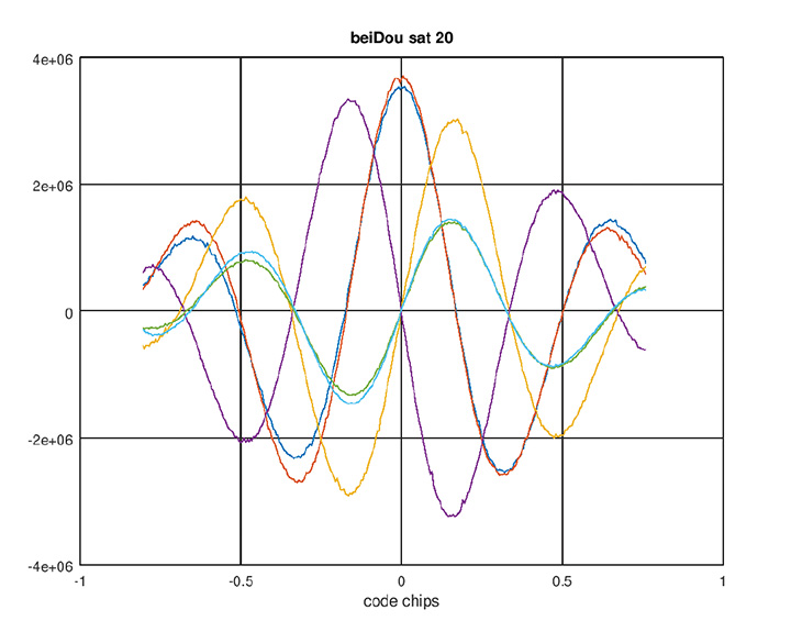
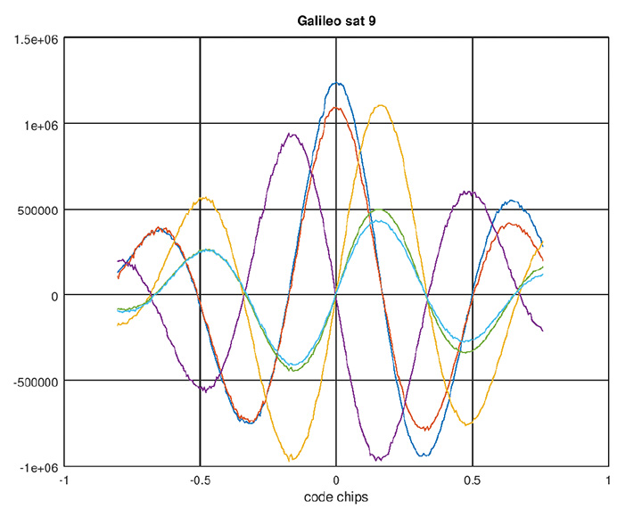
    This B2B signal plus B2A signal together form an AltBOC(10,15) signal on 1191.795 MHz — JAVAD GNSS calls it BaltBOC. Assuming that BOC parameters of this signal are similar to Galileo’s, the company tracked this. Figures 1 and 2 show BeiDou andGalileo (BaltBOC and altBOC) discriminator curves; they appear identical.

    Figure 1. BeiDou AltBoC signal. Red and blue: I of B2A(E5A) and B2B(E5b) sub-signals; purple and yellow: Q of B2A(E5A) and B2B(E5b) sub-signals (their sum is zero); green and aqua: I (early-minus-late) of B2A(E5A) and B2B(E5b) sub-signals.
    Figure 1. BeiDou AltBoC signal. Red and blue: I of B2A(E5A) and B2B(E5b) sub-signals; purple and yellow: Q of B2A(E5A) and B2B(E5b) sub-signals (their sum is zero); green and aqua: I (early-minus-late) of B2A(E5A) and B2B(E5b) sub-signals. (Chart: Javad GNSS)
    Figure 2. Galileo AltBoC signal. Colors same as Figure 1.
    Figure 2. Galileo AltBoC signal. Colors same as Figure 1. (Chart: Javad GNSS)

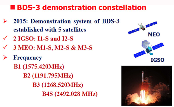
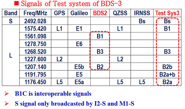
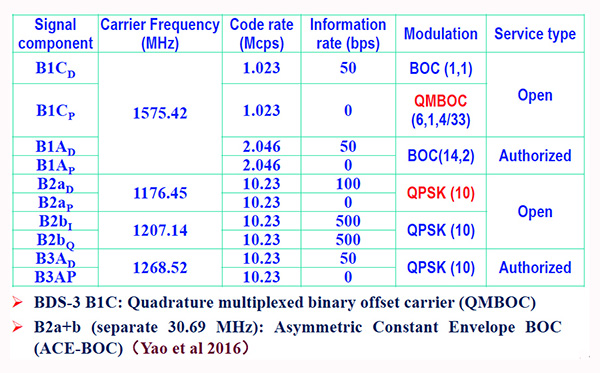
    According to another source, the signals are mentioned in some publications (Figure 3, 4 and 5 from an official Chinese government presentation at the International GNSS Service Workshop, Oct. 2018) and intended to be open signals, but an ICD is presently missing. However there appears to be some clarity now, that the modulation of B2a+b is an “ACE-BOC” modulation, which is similar to but formally different from “AltBOC.”

    Figure 3. BDS-3 demonstration constellation.
    Figure 3. BDS-3 demonstration constellation. (Chart: Javad GNSS)
    Figure 4. Signals of test system BDS-3.
    Figure 4. Signals of test system BDS-3. (Chart: Javad GNSS)
    Figure 5. BDS-3 signal modulations.
    Figure 5. BDS-3 signal modulations. (Chart: Javad GNSS)
  • ComNav Technology tracks third-generation Beidou signals

    Following the successful launch of the third-generation BeiDou satellites, ComNav Technology has been tracking and decoding the BD-3 satellite signals to provide better high-precision positioning services in the near future.

    As the world’s fourth navigation satellite system, the construction of BeiDou satellite navigation network consists of three steps: experimental period from 2000 to 2003, regional coverage by 2012, and global reach by 2020.

    On Nov. 5, 2017, the launch of two third-generation BeiDou satellites indicates that China has begun to upgrade its BeiDou Navigation Satellite System with global-coverage capabilities, according to the China Satellite Navigation Office.

    The new-generation BeiDou satellites feature better accuracy, stability and signal clarity, thanks to improvements in laser communication devices, intersatellite links and atomic clocks.

    Moreover, 18 third-generation BeiDou satellites will be launched by the end of 2018 to cover all nations involved in the Belt and Road Initiative. By the end of 2020, worldwide high-precision GNSS users are able to benefit from global reach of the third-generation Beidou system.

    ComNav Technology has tracked and decoded the latest format BD-3 satellite signals: B1C and B2a from satellites Beidou-19 and Beidou-20.

    The following figure shows the BD-3 No. 20 signal tracked with the SinoGNSS K708 GNSS OEM board.

    Chart: ComNav
    Chart: ComNav

    According to ComNav, with its strong R&D capability in high-precision GNSS, ComNav Technology plans to grow with the third-generation BeiDou navigation system to bring better positioning services all the time.