Telematics company SkyBitz has announced a strategic technology partnership with fleet logistics solutions provider Coretex. The partnership combines Coretex sensor-based refrigeration solution and cloud-based software platform with SkyBitz trailer tracking technology to create a complete solution for businesses needing both powered and non-powered asset tracking.
With the partnership, food, pharmaceutical and retail customers can have total visibility into the status of loads during transportation, resulting in improved food safety and quality assurance.
The SkyBitz and Coretex partnership allow customers to access and manage both reefer device data and trailer tracking data via one seamless solution, enabling greater insight, a more transparent view of their entire cold chain operation, and better decision making. Customers can now automate Food Safety Modernization Act (FSMA) compliance, allowing them to keep assets on the road for longer, monitoring them with advanced temperature tracking capabilities.
“Our customers look to us for innovative, value-driven solutions that help improve profits across their entire operation,” states Henry Popplewell, DVP and president of SkyBitz. “As leaders in the supply chain and logistics arena, we are excited to capitalize on this partnership to continue to grow our cold chain customer base and align ourselves with the foodservice industry through this technology partnership. The Coretex pedigree in last-mile food and beverage distribution is the perfect complement to our asset management technology.”
With this new offering, customers of Coretex and SkyBitz will benefit from the following:
More than 50 features of remote cold chain monitoring capabilities, including two-way reefer control, monitoring of up to six doors, and advanced power management to preserve reefer and telematics unit battery life.
Single point of access to critical and timely best-in-class trailer utilization and reefer information on one seamlessly connected platform, greatly expanding productivity and streamlining operations.
Communication between the trailer and other connected sensors with options to expand to additional Coretex products such as assurance solution CoreTemp.
An unmatched compilation of integrated driver safety, compliance, and asset management tools including the Coretex integration with trailer braking solutions and automatic tire inflation systems.
“Combining SkyBitz leading trailer and asset management technology with Coretex cloud-based software platform, two-way reefer solutions, and deep compliance capabilities create a powerful solution for both companies,” said Coretex CEO Selwyn Pellett. “At Coretex, reefer solutions have been a core part of our business for 16 years, and we’re excited to share our experience with SkyBitz. The trailer expertise of SkyBitz complements our offering, perfectly creating a solution that can help businesses increase the productivity of their assets. With the growing importance of food safety assurance for both food producers and distributors, we think both companies’ customers will find our combined fully-featured solution the best on the market.”
A roundup of recent products in the GNSS and inertial positioning industry from the December 2019 issue of GPS World magazine.
OEM
GNSS simulator
Testing for signals and sensors
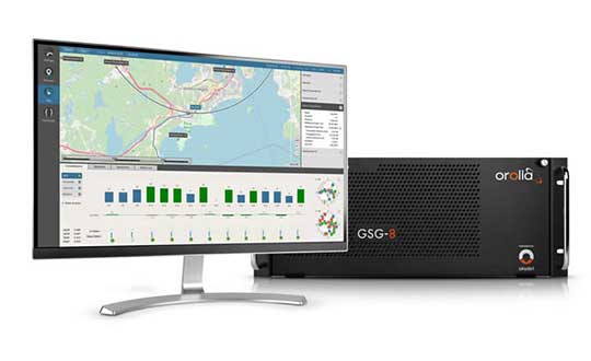
Photo: Orolia
The GSG-8 is an advanced software-defined simulator that offers ultra-high performance and flexibility in an easy-to-use format. It was developed to deliver the highest standard of GNSS signal testing and sensor simulation performance in an upgradable, scalable platform. The GSG-8 uses the robust 1000-Hz Skydel software engine. It is designed for customers who require complex capabilities to validate product and program performance in harsh, high-risk environments where failure is not an option, such as government agencies, space programs and specialized commercial programs.
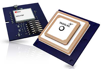
The Edge Locate GNSS L1/L2/E5 module combines antenna, RF electronics and receiver technology to deliver reliable centimeter-level positioning for the internet of things (IoT). It provides 1- to 3-centimeter-level accuracy using multi-band GNSS technology. With Edge Locate, manufacturers can quickly and effectively build devices with centimeter-level positioning technology. Its multi-band GNSS positioning can be used in conjunction with real-time kinematic (RTK) positioning capability. It uses a common connector for integration into any electronics device. It also connects directly to the Taoglas Edge board for immediate connectivity options.
The VSP600L VeroStar precision antenna supports the full GNSS spectrum, as well as L-band correction services, and provides low-elevation satellite tracking with a high-efficiency radiating element. It is suitable for real-time kinematic (RTK) and precise point positioning (PPP) applications, and features a light, compact and robust design. It also has a low axial ratio through all elevation angles, providing strong multipath rejection. The VSP600L VeroStar provides high receive gain over the full GNSS spectrum: low GNSS band (1164 MHz to 1300 MHz), L-band correction services (1539 MHz to 1559 MHz) and high GNSS band (1559 MHz to 1610 MHz).
Tallysman, www.tallysman.com
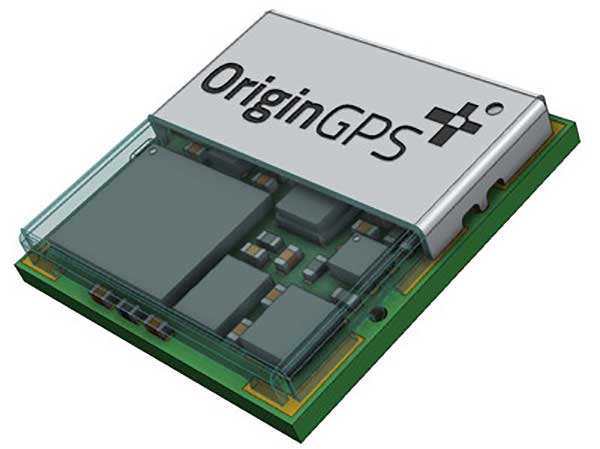
L1 + L5 chip
Suitable for IoT and auto OBD
Photo: OriginGPS
The ORG4600-B01, OriginGPS’ first dual-frequency GNSS module, is supported by the BCM47758 chip, enabling ultra-accurate GNSS positioning. It was developed for solutions requiring super-precision GNSS and a dual-frequency combination. The module enables customers to build solutions with sub-1-meter accuracy without implementing external components. Measuring 10 x 10 millimeters, the ORG4600-B01 supports L1 + L5 GNSS reception with one RF port, enabling use of a low-cost, dual-band antenna delivering sub-1-meter accuracy performance in real-world conditions. An alternate build option allows for separate L1/L5 RF outputs when dual antennas are required. The module is suitable for solutions requiring ultra-accurate positioning, such as telematics, the internet of things (IoT) and auto OBD applications.
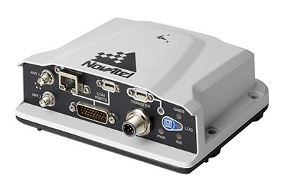
The PwrPak7-E2 contains an advanced Epson G370N MEMS inertial measurement unit (IMU) to deliver NovAtel SPAN technology in an integrated, single-box solution. It has a powerful OEM7 GNSS engine, built-in Wi-Fi, onboard NTRIP client and server support, and 16 GB of internal storage with higher performance and INS data rate. Connection options include serial, USB, CAN and Ethernet. Features include a 555-channel, all-constellation, multi-frequency positioning solution and multi-channel L-band that supports TerraStar correction services. It can be paired with an external receiver to support ALIGN GNSS azimuth aiding for low dynamic applications.
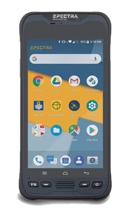
The MobileMapper 60 is a durable, efficient and accurate handheld device for geographic information system (GIS) and professional data-collection applications. The all-in-one GNSS receiver and smartphone offers 2-4 meter positioning accuracy in an all-weather design with a hand strap. It operates in extreme temperatures and rugged field conditions. It features a 6-inch high-resolution screen, large capacity all-day battery, Android 8.0 operating system and 2.2-GHz processor. Its 4 GB of memory and 64 GB of storage can manage large data sets with ease and speed. Bluetooth 4.1, 4G LTE and Wi-Fi capable, the MobileMapper 60 is suitable for cadastral, survey, topography and forestry.
Spectra Geospatial, spectrageospatial.com
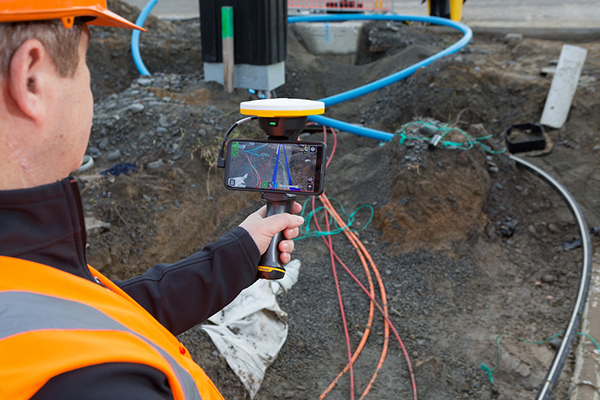
Outdoor AR
Enables visualization of 3D data
Photo: Trimble
The SiteVision outdoor augmented reality (AR) system enables users to visualize 2D and 3D data with cellular or internet connectivity for planning, collaboration and reporting. Combining hardware and software in an integrated, lightweight handheld or pole-mounted solution, users can view 3D models and assets in a real-world environment at a 1:1 scale, from any angle or position. SiteVision integrates a Trimble Catalyst DA1 antenna, electronic distance measurement (EDM) rangefinder and power management into a lightweight, handheld device that connects to a user-supplied Android mobile phone. The SiteVision subscription is available monthly or yearly, and combines Trimble’s high-accuracy positioning services and cloud-based processing technology to create a centimeter-accurate AR system. Users can visualize digital models from a wide range of data collection, design and constructible modeling tools in open industry-standard formats, including IFC and LandXML. For civil projects, SiteVision accurately visualizes data from Trimble’s Quantm, Business Center and Novapoint; design data from Civil 3D and Bentley OpenRoads; and GIS data from Esri ArcGIS software.
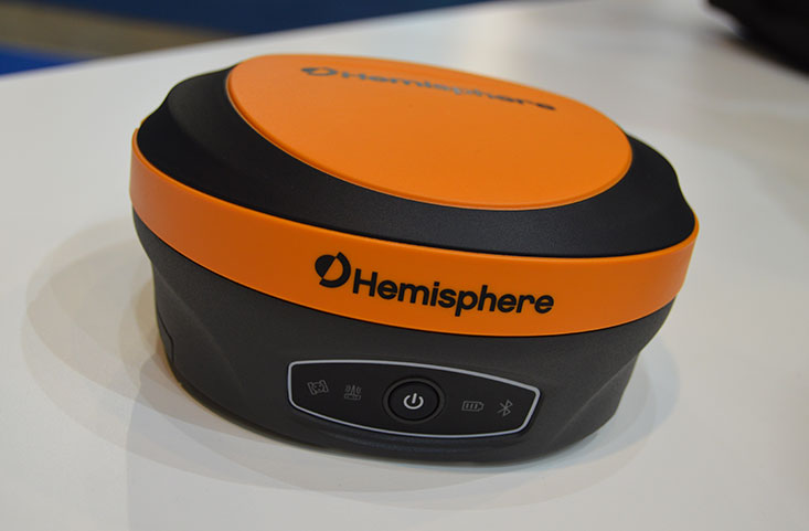
The S621, powered by the Phantom 40 GNSS OEM board, is a redesign of Hemisphere’s previous S321+. It processes and supports more than 800 channels with flexible and scalable simultaneous tracking of every modern and planned GNSS constellation and signal including GPS, GLONASS, BeiDou (including Phase 3), Galileo, QZSS, IRNSS, SBAS and Atlas L-band. The S621 combines Hemisphere’s Athena GNSS engine and Atlas L-band correction technologies with a new web user interface. It meets IP67 requirements and is immune to magnetic interference. It is designed for use in land or marine survey, GIS, mapping, construction or other applications requiring high-performance precision and positioning.
Records and transfers raw data for post processing
Photo: Geneq
The SXblue ToolBox is now available for iOS-compatible devices. The application was developed with special interest paid to raw data recording and NTRIP service connection. The Android application debuted in 2018. With the new iOS application, iPhone and iPad users can analyze the position data provided by the SXblue receiver, as well as location metadata. The application can record, save and transfer raw data from the GNSS receiver, thereby allowing post-processing activities. The application also acts as an NTRIP client, capable of connecting to an NTRIP server for real-time kinematic (RTK) corrections, and thus allows the receiver to issue very accurate location information. Receiver configuration is easy through the application, with the ability to set up and save user-defined commands for subsequent use. The settings include constellation to be used, differential source, NTRIP login credentials list and more.
TRANSPORTATION
Telematics for Ford
Simplifies mixed-fleet management
Photo: Ford
The Geotab Integrated Solution for Ford Vehicles integrates Ford vehicle data into the MyGeotab platform to give fleet managers a dedicated portal to process data. Ford Data Services securely transfers data from Ford vehicles with a factory installed or plug-in modem to Geotab’s cloud environment. It provides access to the Geotab Marketplace, a portfolio of mobile apps, hardware add-ons and software add-ins.
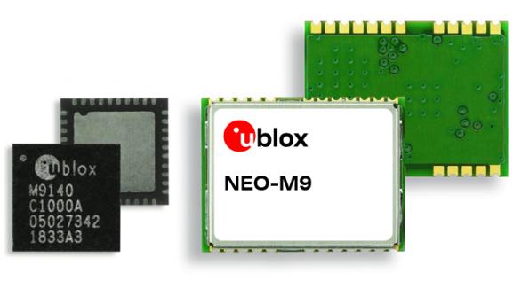
The M9 platform is designed for demanding automotive, telematics and UAV applications. With the u-blox UBX-M9140 GNSS chip, the M9 technology platform and the NEO-M9N (the first module based on the platform) can receive signals from GPS, GLONASS, BeiDou and Galileo concurrently. It can achieve high positional accuracy in difficult conditions such as deep urban canyons. The M9 offers a position update rate of up to 25 Hz, enabling dynamic applications to receive position information with low latency and has special filtering against RF interference, jamming and spoofing. U-blox also provides Explorer Kit M9 (XPLR-M9) for developers.
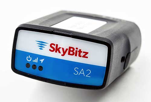
The SA2012 GPS tracker is equipped with the latest 4G LTE with 3G fallback. It is designed for customers looking for a scalable vehicle telematics solution. The hardware can be installed using the SkyBitz Ops Center mobile device, either directly plugging it into the vehicle diagnostic port or covertly installing it behind the dashboard. Once installed, the device feeds into the Ops Center platform, where users can manage the new device and others via a single interface. Coverage is across North America.
SA2012 offers customers configurable GPS tracking device on the latest 4G network
Photo: SkyBitz
SkyBitz has launched the SA2012, equipped with the latest 4G LTE with 3G fallback, positioned for the light- to medium-duty vehicle tracking market.
With the option to purchase a range of price packages with configurable feature sets, the SA2012 is designed for customers looking for a scalable vehicle telematics solution they can use to increase profit margins and satisfy customer demand.
The hardware can be installed using the Ops Center mobile device, either directly plugging it into the vehicle diagnostic port or covertly installing it behind the dashboard, depending on customer preference.
Once installed, the device feeds into the SkyBitz Ops Center platform, where users can manage the new device alongside all others via a single interface. Customers will have coverage across North America, including Mexico and Canada.
The basic package includes GPS location data and estimated odometer and engine hours. With several options leading up to the Pro package, SkyBitz offers a variety of location, engine, and safety data that can be selected based on the customers’ operational goals and budget.
Customers can configure their solution with minimal training, adding features such as advanced alarms and notification schedules and over-the-air upgrades when future features are released.
“SkyBitz strives to bring the latest technology to market that meets industry demand but also exceeds our customers’ expectations. This is one more device added to the SkyBitz product line that is now delivered on the latest network, and integrated into the SkyBitz Ops Center platform so customers can easily see vehicle and asset data on one dashboard,” said Debbie Sackman, senior product manager with SkyBitz. “This device targets small and medium businesses and offers a flexible package choice where customers can add additional features with OTA upgrades as their business grows.”