Tag: Skyhook

  • DOT holds first GPS backup technology demonstration

    DOT holds first GPS backup technology demonstration

    Notes from DoT GPS Backup Demos – Part I

    Government officials, advisors and congressional staff gathered at NASA’s Langley Research Center on March 13. They were there to discuss the Department of Transportation’s (DoT’s) GPS Backup Technology Demonstration program and view the offerings of six different companies.

    A second event to view and discuss technologies offered by the other five companies in the program is scheduled (as of this writing) for Friday, March 20, at Joint Base Cape Cod, Massachusetts.

    View from Washington, D.C.

    The day began with remarks by Karen Van Dyke from the U.S. Department of Transportation, as well as remarks prepared by Colonel Joseph Frankino, deputy director of the National Coordination Office, a multi-agency staff that supports the National Space-Based Positioning, Navigation, and Timing (PNT) Executive Committee, whose members were unable to attend.

    Van Dyke provided an overview of the program and pointed out the increasing importance of resilient PNT. As just one example, improvements in autonomy and self-driving cars are entirely dependent upon consumers having confidence in the entire system, much of which is underpinned by PNT.

    Col. Frankino’s remarks reflected the Defense Department’s commitment to and support of DoT’s resilient PNT efforts. He pointed out that the nation’s military depends upon the defense industrial base, which depends upon uninterrupted PNT.

    Volpe Transportation Systems Center

    The technology demonstration effort is being coordinated by Andrew Hansen from DoT’s Volpe Center. Dr. Hansen pointed out that the ongoing effort, the analysis and assessment of which is expected to be concluded in May, is a series of demonstrations vice tests. This means that the companies involved were showing what their systems could do, vice being measured against set criteria.

    He also mentioned that the maturity of all the systems involved seems to have improved significantly over the last year. All are at Technical Readiness Level 6 or better. Also, that things so far had gone very smoothly with no need for any “re-dos.”

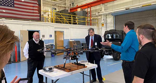
    GPS and a cesium clock were being used as reference standards for the demos. Two of the systems, NextNav and Skyhook, were also demonstrated on a drone at Langley’s 150 acre open air site.

    Report and Transparency

    Data from the demos is not proprietary and belongs to the government which intends to make “as much of it available as possible.” DoT representatives mentioned several times their desire for maximum transparency.

    Admiral (ret.) Thad Allen (left), chair of the National PNT Advisory Board, was among the attendees learning about DoT’s GPS Backup Technology Demonstration project at NASA’s Langley Research Center. (Photo: RNT Foundation)
    Admiral (ret.) Thad Allen (left), chair of the National PNT Advisory Board, was among the attendees learning about DoT’s GPS Backup Technology Demonstration project at NASA’s Langley Research Center. (Photo: RNT Foundation)

    Attendee Observations

    After a day of viewing and discussing the six different technologies with their vendors, the group reconvened to offer feedback. All agreed the day was very worthwhile and complemented DoT and NASA on the event.

    Kicking off the discussion, the DoT hosts remarked that the department is fully committed to GPS and its modernization. That said, there is broad recognition of the importance of other PNT systems. This is evidenced by the recent White House Executive Order on PNT.

    Also, that there is no single solution that will fill the PNT needs of everyone. In fact, GPS does not serve the PNT needs of everyone. The need across sectors for a wide variety of sources to “backup” GPS is why the demonstration project includes some systems that only provide time, or only positioning.

    Feedback from attendees included:

    • The reason for this project is that we have a 20th-century GPS and 21st-century threats. New technologies need to be examined for vulnerabilities. Security must be “baked in” from the beginning. Moderators commented that the DHS Conformance Framework was one of the tools that would help with this.
    • Rural and other underserved areas (such as wilderness, remote transportation networks, maritime) need PNT and should be a part of the government calculus.
    • Many systems depend upon infrastructure provided by others versus being self-sufficient.
    • In the view of many in Congress, it is good to see the demos going well. Overall, though, things are about two years late. Members and staff are very interested in when there will be an RFP and schedule for implementing the timing system mandated by the National Timing Resilience and Security Act of 2018.
    Monty Johnson of OPNT demonstrates precise time transfer through 100 kilometers of spooled fiber-optic cable. (Photo: RNT Foundation)
    Monty Johnson of the company OPNT demonstrates precise time transfer through 100 kilometers of spooled fiber-optic cable. (Photo: RNT Foundation)

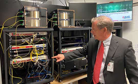
    Systems Demonstrated at NASA Langley

    During the course of the day, attendees had the opportunity to interact with representatives from the following companies and their systems.

    Vendor Service Technology
    TRX Positioning Inertial Measurement Units
    NextNav Positioning & Timing Metropolitan Beacons
    Skyhook Positioning WiFi, cell ranging, very large proprietary database of site locations
    Echo Ridge Positioning & Timing Uses Global Star LEO constellation of 24
    OPNT Timing Timing Fiber & White Rabbit protocol
    Seven Solutions Timing Timing Fiber & White Rabbit protocol


  • Skyhook to provide location service protections to Rivetz network

    Skyhook to provide location service protections to Rivetz network

    Image: iStock/hanibaram
    Image: iStock/hanibaram

    Skyhook is partnering with Rivetz to integrate Skyhook’s global mobile location services to enhance the Rivetz platform.

    Skyhook is the operator of a worldwide independent location services platform. The company’s technology provides the foundation for mobile location services in the global market for connected devices.

    Skyhook’s hybrid positioning system locates devices using observed radio signals — including GNSS, Wi-Fi and cellular — ensuring that all devices can be located in all environments.

    Rivetz offers decentralized, embedded cybersecurity tools.

    By enabling Skyhook’s advanced location capabilities on the Rivetz Network of cybersecurity tools, Rivetz users can take advantage of location service protection in any signal environment, regardless of GPS availability.

    Accurate and accessible device location services are a critical component of all end-to-end security solutions, particularly in regulated environments or other markets where trusted and verifiable location is a requirement.

    “We are pleased to partner and collaborate with Rivetz, a trusted leader in decentralized mobile security,” said Kipp Jones, Chief Technology Evangelist of Skyhook. “We share the values that our products must be built on the pillars of trust and respect for individual privacy. We look forward to providing Skyhook’s industry-leading location services to the Rivetz Network.”

    “We are proud to join forces with Skyhook to enable powerful location services to the Rivetz Network,” said Steven Sprague, co-founder and CEO of Rivetz. “A simple and safe security model is our greatest priority, and precise device location is a cornerstone of protecting our cybersecurity solutions.”

    Rivetz’s security solutions hinge upon access to the Trusted Execution Environment (TEE), which is an isolated, measured computer environment separate from the operating system. By provisioning all digital transactions through the TEE, Rivetz assures that users’ private keys cannot be altered or stolen if the operating system were tampered with or infected by malware.

  • Location-Based Advertising Getting Higher Visibility

    Location-Based Advertising Getting Higher Visibility

    Airpush-MWC
    Airpush

    When one talks about the worldwide location industry, mobile resource management — fleets and trucks, for instance — aren’t sexy at all, but they make money. What is supposed to be sexy is location-based advertising.  According to many analysts, location-based advertising has been hampered by a few things: education for both consumers and mobile advertisers, privacy issues, and relevant proximity information so folks can use it to make purchases. Another concern could be the expense of rolling out indoor beacons.

    BARCELONA—Major consumer privacy concerns aside, companies are starting to see growth in location-based advertising, with new markets emerging in Europe. While the numbers of mobile advertising companies has decreased at the Mobile World Congress, held here in February, from just two years ago, the remaining players are seeing a more mature market.

    Mobile advertisers are beginning to realize that location is the Holy Grail for growth, said Cameron Peeples, Airpush vice president of marketing. “People going into New York from Newark during rush hour can receive a different call to action because of a created geo-fence. Advertisers can determine whether the traveler is there on business or looking for a hotel and other travel deals,” he said.

    Before Mobile World Congress, Los Angeles-based Airpush partnered with AirX, a large mobile ad exchange company. The majority of the AirX inventory, about 120,000 Android applications, includes highly-sought-after GPS location data, the company said.

    There are large differences between the North American and European markets for mobile advertising, Peeples said. “The mobile advertising market [in Europe] is definitely evolving. The European market is key for us, dramatically higher than other markets,” he said. “[The European] market seems to have people connected to a lot of things — they are more mobile, use public transportation more, and always have a phone that is more centric to who they are.”

    Making location-based advertising relevant to the consumer is still a major challenge. “Our focus next year is on native advertising. Native advertising combines not only the right message, but the right delivery vehicle,” Peeples said. “No one bicycling enthusiast wants ads tailored for someone who wants flowers.”

    Peeples said the privacy issues are a big deal, but his company’s services are opt-in. “A lot of it is loyalty advertising. It’s all opt-in,” he said.

    xAd Partners with Waze, Sees UK Growth

    Another mobile advertising company, New York-based xAd, is also making inroads in Europe. “We are in the UK right now, which is really WiFi-focused. A lot of our early [location-based] advertising efforts are in education — to educate consumers and the advertising agencies about the power of location and mobile,” said Monica Ho, xAd vice president of marketing. “Not all location is created equal. The real value of [location-based advertising] is the proximity target to market to.”

    Right before Mobile World Congress, Waze selected xAd as its third-party provider of search and display mobile ads in the United States. Waze, which was bought by Google in a deal worth more than $1 billion, is a top three map and navigation app in the iTunes store — a ranking that was probably helped by the Apple Maps debacle in 2012.

    The companies say the deal will place xAd’s mobile ad targeting technologies into Waze’s location-based advertising platform.

    Ho said there are still two areas of concern for location-based advertising: relevancy to the consumer and privacy issues. “There was privacy backlash from Nordstrom collecting consumer information from their Wi-Fi system,” she said, referring to the controversy last year when the retailer was accused of capturing consumer information during an indoor positioning test.

    Apple to Roll out Upgraded Maps on iPhone 6

    Speaking about Apple Maps, many industry analysts says the company has come a long way since the very public embarrassment nearly two years ago over map inaccuracies and flaws. The company recently released iOS 7.1, but is expected to rollout iOS 8 when the iPhone 6 debuts later this year.

    With the debut of the iPhone 6, an updated version of Apple Maps will also be released, according to published reports.

    Last year, Apple bought two companies, HopStop and Locationary, to allow the company to entrench itself once more in the location business. How firmly those roots prove to be, and how well they serve the company against archrival Google, remain to be seen.

    Apple has been stockpiling companies and mapping software since its introduction of Apple Maps on iOS devices, which had a rough start. GPS World’s LBS Insider reported extensively on the problems Apple encountered with its mapping software. Some of these problems included sending drivers to a wrong location and direction.

    After the mapping software problems were made public, Apple CEO Tim Cook apologized for the mapping software’s problems and even suggested that users go to such competitors as Waze, MapQuest, and Microsoft’s Bing.

    In other location news:

    • A Wall Street Journal reporter basically said there was nothing much new at Mobile World Congress — and that the excitement and action was at the outlying conferences at Fira Montjuic. One of these more interesting conferences, Four Years From Now, or 4YFN, featured start-up companies making pitches and displaying their new products, some of which included location capability.
    • The Mobile World Congress final stats. Organizers said MWC had more than 85,000 attendees from 200 countries — an increase of 13,000 from the previous year. It’s now being touted as the biggest and best wireless show.
    • In February, GPS World reported that TruePosition had purchased Skyhook for an undisclosed price. Skyhook provided location services to a number of companies including Apple and Samsung. The interesting issue is Skyhook’s lawsuit with Google, which alleged that the Internet giant influenced smartphone manufacturers to abandon the Boston-based company. According to published reports, the legal action still is going forward.
    • AT&T Mobility is shuttering its location-based Alerts marketing program. The company said it would release an updated version later this year. AT&T Mobility launched Alerts in late 2012. It featured free opt-in, location-based text message alert service. Participating retailers included Stapes, Gap, Zales, Neiman Marcus, and others.
    • I didn’t go to South by Southwest. Is my cool-guy card revoked? One of the reasons I didn’t is because, outside of meetings that were not part of the conference, there was not one location industry announcement made there. Maybe something will change my mind next year, but call me an old fogey — I just didn’t see the need to go to Austin this year.


  • Comodo Integrates Skyhook Wireless Location Tech into Android Anti-Theft App

    Skyhook Wireless, a provider of location positioning, announced a partnership to integrate Skyhook’s hybrid location platform into Comodo’s Anti-Theft app for Android devices.

    Comodo’s Anti-Theft for Android is a new service that enables customers to remotely locate, lock and recover a lost or stolen Android smartphone or tablet. The app can remotely capture and upload photos of whoever is operating the missing device to aid authorities in their recovery efforts and also in identifying the thief.  The product is designed to address the security, monitoring, and management needs of users with limited time and IT support.

    “Comodo selected Skyhook’s leading hybrid location service because of its precision, speed, and power efficiency, all of which are critical to Comodo in our mission to locate, track, and recover lost or stolen devices,” said Melih Abdulhayoglu of Comodo.

    Comodo Anti-Theft for Android is free and available at the Android Play Store. Skyhook provides an SDK for developers across most platforms.


  • Skyhook, Philips Lifeline Develop Location Platform for Emergency Response

    Skyhook and Philips Lifeline have announced a collaboration to incorporate Skyhook’s hybrid location positioning platform into Philips’ Lifeline GoSafe mobile personal response services. Skyhook’s hybrid location service will be part of a suite of locating technologies used with the new GoSafe system and designed to help provide the call center with the location information needed to support locating of users in the event of an emergency.

    “Accurate location information is of critical value to ensuring the quick dispatch, arrival and delivery of what is often life-saving assistance,” noted Rob Goudswaard of Philips Home Monitoring. “After reviewing the market, we concluded that Skyhook’s location network and technology capabilities were consistent with our requirements for enabling timely and accurate response.”

    “If an individual experiences a fall or other emergency, quickly getting help to the right location is of vital importance,” said Michael Shean of Skyhook. “Skyhook is proud to partner with Lifeline, the leading medical alert service, in order to enhance the safety and care that Lifeline provides to all of its customers.”

  • Two New Kindle Fire Apps Leverage Skyhook Technology

    Skyhook, a location information, context and intelligence company, has announced that two new Kindle Fire apps have integrated Skyhook to provide location services on this device. The applications include Happy Hour Finder and Scope. They join a list of other apps using Skyhook for location services on the Kindle Fire, including MapQuest, KAYAK, deCarta, and TweetCaster.

    Happy Hour Finder is a local search app that shows the nearest bars and restaurants with discount happy hours. Scope is an aggregated social media app that organizes all of a person’s social networks in one place.

    “"Location check-ins are a valuable piece of the complete social picture Scope provides of your friends' activity,"” said Anit Kumar, CEO of Scope. “"We knew we couldn'’t launch the app on Kindle Fire without location, and wanted to ensure all of our Android versions were the same, so Skyhook was necessary.”"

    "Developers are increasingly concerned with Android fragmentation,"” said Maggie Taylor, marketing manager of Skyhook. "“Our system provides consistent location functionality and protects developers from this problem, so apps are built once and will work across the board.”"

    Happy Hour Finder and Scope are both free and available today in the Amazon App store for download. Skyhook provides an SDK for developers across most platforms.

  • Location Industry Hits Speed Bump

    Location privacy issues have the power to put the skids on our industry. When I stepped into the Where 2.0 show, little did I know I was about to see Apple publicly open its kimono, reveal its location collection practices, and further fuel public and government outrage on location privacy.  Apple doesn’t stand alone as Google also stores similar data on Android devices. And in a smaller breach, TomTom’s user location data was sold to the Netherland’s government, helping  to optimize the placement of speed traps. Congress responded by hauling Apple and Google into a Congressional subcommittee meeting. Senator Patrick Leahy captured the hearing’s mood when he said, “American consumers and businesses face threats to privacy like no time before.” He went on to say that he was “deeply concerned” about the reports that iPhones and Android devices were “collecting, storing, and tracking user location data without the user’s consent.”

    Apple’s recent revelation was that its iOS operating system stores user location data in a hidden file. The location was being provided to iTunes during back-ups, giving Apple a log of a user’s movements and activities, for up to a year. A new iOS version reduces the log to a week of data and ends the back up to iTunes. The cache can be eliminated by disabling the device’s location feature.

    Leak from Google Skyhook skirmish. Larry Page, now-CEO of Google, sent an e-mail last year to top executives with the news that Motorola had chosen to use Skyhook, and not Google, location services. According to e-mails leaked to the San Jose Mercury News, Google executives responded by emphasizing the importance of collecting location data from smartphones, and the value of the data.

    “I cannot stress enough how important Google’s Wi-Fi location database is to our Android and mobile product strategy,” Google location service product manager Steve Lee wrote. “We absolutely do care about this (decision by Motorola) because we need Wi-Fi data collection in order to maintain and improve our Wi-Fi location service.”

    At the beginning of 2010, because of public concerns, Google had stopped collecting Wi-Fi data from vehicles used to capture street images for Google Maps’ Street View feature. When the vehicles also scanned an area for Google’s location database, Google admitted that in doing so, it inadvertently collected personal data from unsecured wireless networks. Google had turned to collecting location data via Android phones and the Skyhook move was seen as a major threat.  Motorola later decided to resume using Google’s location services, and Skyhook Wireless sued Google for patent infringement and interfering in its business relationship with Motorola.

    Who’s there? Location veteran Duncan McCall unveiled PlaceIQ at Where 2.0. The company provides meaning to hyper locations, categorizing the types of people, places, social, and digital activity that occurs within a city block or 100 square meters. PlaceIQ doesn’t use personal information but tries to infer information about people situated at a location. For instance, a location might be a trail head at a popular hiking destination or a tourist spot like Fisherman’s Wharf in San Francisco. Place IQ can identify locations in which an advertiser’s target audience has a likelihood to be present.

    Let’s make a deal. Groupon purchased location-enabled social networking company Pelago (Whrrl).  Look for Groupon to take on foursquare, which has led in social networks and local check-in market.  Groupon will move beyond being a new customer acquisition tool to adding a social platform on which a location-enhanced social community will exchange recommendations and insights on deals. A loyalty program will be added to reward check-ins and usage.  Groupon will expand beyond its current local small businesses focus to include national brands and large retailers.

    Keep your hand on your pocket. eBay wants to be your mobile wallet. The company just purchased location-based services provider Where.  Previously called uLocate, Boston-based Where develops mobile advertising, search, recommendation and daily deals services. Where will be housed in eBay’s PayPal division and used to strengthen the company’s position in mobile and hyper local shopping and deals. This fits with eBay’s earlier acquisitions of local shopping start-up Milo, barcode scanning developer RedLaser, and online retailer GSI Commerce.

    Got mail. Last month’s column highlighted indoor location and generated unprecedented mail to my inbox. I mentioned a few companies providing apps that involve indoor mapping or locations, but as many pointed out, there are more. Others include Eakahau, Ehud, Fast Mall, Geodelic, Les Quatre Temps, Point Inside, and Spotlight Mobile. I’d like to clarify that Aisle411 maps offer routing and some interactive capabilities. Choices for indoor positioning include both handset and network solutions like Wi-Fi, GPS, Bluetooth, U-TDOA, Wi-Fi,  radio frequency pattern-matching, and geo-location sensors.

    Mapping for good. Ushahidi, a non-profit organization, developed open software and interactive mapping for “crowd voicing” to increase transparency and allow people to document their condition. After the Kenyan disputed election, 45,000 users contributed information about violence and peace activities throughout the country. The platform was also used after the Haiti earthquake. Ushahidi utilizes an elite team of volunteers for coding and other important jobs. Get involved.