Tag: Slingshot Aerospace

  • Slingshot Aerospace advances GPS jamming detection for military intelligence and security

    Slingshot Aerospace advances GPS jamming detection for military intelligence and security

    The U.S. Space Force’s Space Systems Command (SSC) has awarded a $1.9 million contract to Slingshot Aerospace to enhance its GPS jamming and spoofing detection capabilities. This contract, Positioning, Navigation and Timing – Secure Electronic Navigation Threat Intelligence and Location (PNT-SENTINEL), aims to improve the company’s existing technology by incorporating advanced artificial intelligence and predictive analytics.

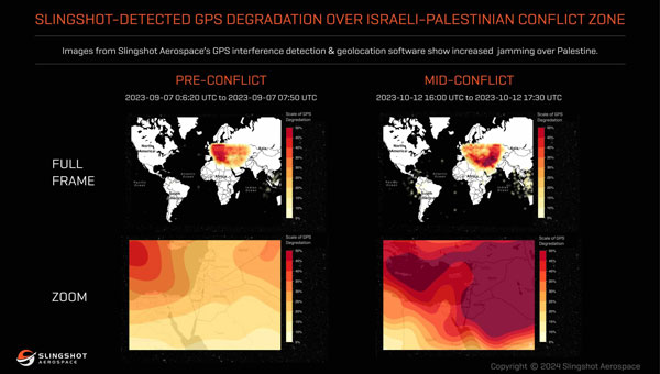
    The PNT-SENTINEL program builds upon Slingshot’s previous work under the Data Exploitation and Enhanced Processing (DEEP) contract, awarded in October 2021. The technology developed through DEEP currently assists the U.S. Space Force in detecting GPS jamming and ground-based interference sources related to ongoing conflicts, potential future conflict zones and counterterrorism efforts.

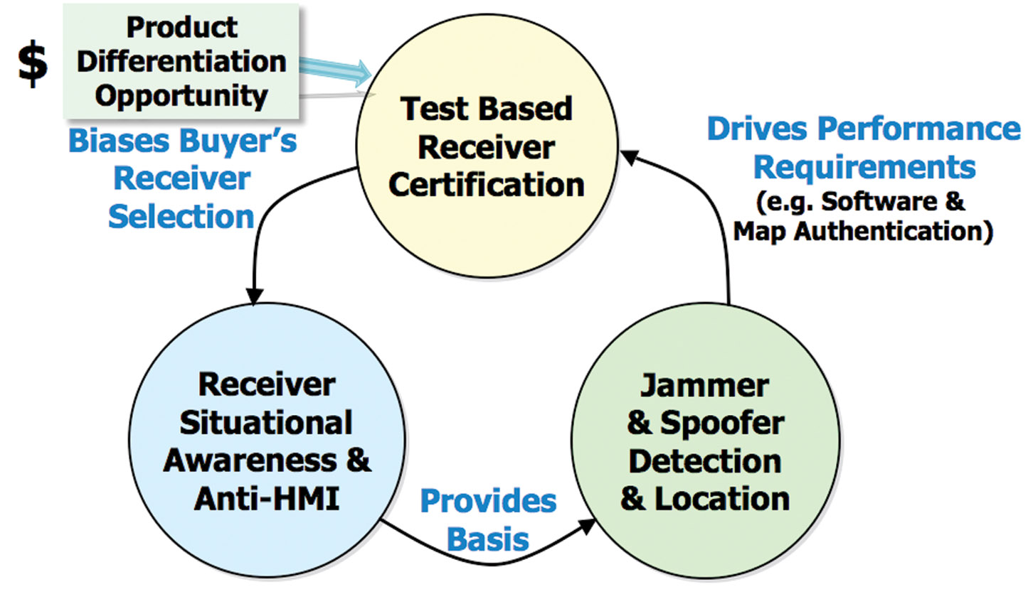
    GPS spoofing and jamming pose significant threats to both military operations and civilian infrastructure. Such interference can impact a wide range of operations, including satellite systems, ground and air operations and critical services such as commercial airline operations and vehicle navigation. The global reliance on GNSS has increased the importance of protecting these signals from interference.

    Slingshot’s technology utilizes a mesh network of thousands of satellites to create a near-real-time picture of GPS jamming occurrences worldwide. This space-based approach offers a more comprehensive view of global jamming conditions compared to traditional ground-based detection systems.

    As part of the contract, Slingshot will integrate its AI model, Agatha, into the PNT-SENTINEL system. This integration aims to enhance the technology’s ability to detect and differentiate between unintentional interference and deliberate jamming or spoofing attempts. The improved system will also implement pattern recognition algorithms to identify active jamming events and predict how situations may evolve.

    The contract also includes provisions for expanding the system’s capabilities to monitor interference across multiple GNSS sources, not just GPS. This multi-GNSS processing will allow for a more complete, real-time view of jamming activities by incorporating data from allied nations’ spacecraft.

    The PNT-SENTINEL system is designed to be interoperable with existing military systems, enabling near-real-time information dissemination to support rapid decision-making in national security operations. These enhancements aim to provide warfighters with a strategic advantage in GPS-contested environments.

  • Spire constellation helps detect GPS jamming in space

    Spire constellation helps detect GPS jamming in space

    Image: Spire Global
    Image: Spire Global

    Spire Global Inc., a provider of space-based data, analytics and space services, is using its constellation of about 40 geolocation satellites to detect GPS jamming. Spire is collecting data for use by the U.S. Space Force, a particularly important task in light of Russia’s invasion of Ukraine.

    “All of our fellow space companies… everyone is playing a vital role for humanity in this battle for freedom and democracy,” Spire CEO Peter Platzer told analysts March 9 in an earnings call, according to Space News.

    In September 2021, Spire won a contract to supply Slingshot Aerospace with GPS telemetry data. Slingshot’s pLEO Data Exploitation and Enhanced Processing (DEEP) prototype will automate manual data exploitation techniques to deliver intuitive, easily digestible data products at low latencies for military operations.

    The DEEP prototype contract is funded through the the Commercially Augmented Space Inter-Networked Operations (CASINO) program of the Space Systems Command (SSC), which develops and demonstrates the military utility of proliferated LEO satellite architectures.

    Identifying and mitigating ground-based radio-frequency (RF) and GPS interferences is a critical component of national security and U.S. Space Force operations. RF signals intercepted in open airspace are liabilities that directly threaten on-orbit space assets and military missions.

    Even in the absence of enemy interference and intentional jamming, RF signals from radio stations, cell phones, and various electronics cause interruptions and interferences — a problem exacerbated by the growth of modern communications technology.

    The DEEP prototype is an effort by the U.S. military to take advantage of existing commercial satellite telemetry data to readily identify these sources of interference and correct any potential problems before they become a threat.

    Spire’s cubesats use GPS radio occultation, a remote sensing technique that measures properties of the Earth’s atmosphere from space.

  • Mapping tool helps LA County residents find food resources

    Mapping tool helps LA County residents find food resources

    Screenshot: FoodFinder
    Screenshot: FoodFinder

    The non-profit 211 LA County and Slingshot Aerospace have unveiled an online mapping tool that allows users to quickly identify and locate more than 2,000 food resources within the county during and after the COVID-19 pandemic.

    211 LA County is a non-profit organization providing the official information and referral source for health and human services in LA County. Slingshot Aerospace is a situational intelligence platform company,

    The customized tool, called 211 LA FoodFinder, is powered by Slingshot Earth and is the biggest and only food map that allows LA residents to search for resources by location and view services specific to seniors, children and others, enabling individuals to find aid near them faster. Resources within the FoodFinder are free, with the exception of those with suggested donations or delivery service fees.

    LA County residents will be able to identify different types of available food resources, such as child nutrition, meal services, groceries/food pantries, senior food needs and government food benefits programs.

    The platform also provides location details, hours of operation and contact information for each of the services. 211 LA County is currently experiencing a tenfold increase in website traffic related to food resources compared to pre-COVID timeframes.

    The organization anticipates the robust application to service nearly 30,000 LA County constituents over the next quarter, many of which may not have prior experience with food assistance.

    “Food resources are the biggest need people are contacting us about since the COVID-19 pandemic hit LA County,” said Maribel Marin, executive director, 211 LA County. “With so many people out of work, the need for food is going to get progressively more intense, but people shouldn’t worry because there are lots of resources and ways to access them. Our custom Slingshot Earth food locator provides our community with a one-stop-shop for food resource information, helping to provide peace of mind to those who need food assistance during this unprecedented time.”

    211 LA County’s customized Slingshot Earth mapping tool aggregates food resources and service data from multiple public and private sources so that individuals have the right information, at the right time, all in one place. The data is verified and updated regularly to ensure that Los Angeles County residents have the most up to date information as guidelines and offerings continue to evolve.

    “This work to help 211 LA County provide critical food service information in our community is so meaningful to us because we are driven by a vision to create a safer, more sustainable world,” said Mel Stricklan, Co-Founder and Chief Strategy Officer, Slingshot Aerospace. “Our business was founded on the idea that information is power, especially in complex situations. The COVID-19 pandemic is uncharted territory for all of us, and we are happy to do our small part in navigating these tough times by providing essential information to those who need it most.”