Streaming 3D geospatial technology company Cesium will support the Smithsonian Institution by streaming 3D models of massive objects in its collection, such as the Space Shuttle Discovery. The models will be streamed over the internet in high resolution for the first time.
The collaboration is part of the Smithsonian’s Open Access Initiative. Through the initiative, the Smithsonian will release about 2.8 million 2D and 3D images, public collections metadata, and institutional research data sets as Creative Commons (CCo) for any purpose, such as education, research, commercial endeavors, creative reuse, computational analysis, and innovative explorations.
“The Smithsonian Open Access Initiative aligns perfectly with Cesium’s vision to make the world’s collection of data more useful and accessible,” said Cesium CEO Patrick Cozzi. “We are proud that our technology will give researchers, educators, and the public the ability to study 3D models in the Smithsonian’s collection in the highest resolution detail from anywhere in the world.”
Cesium Stories enable 3D storytelling
Cesium Stories enable creation and sharing of 3D geospatial presentations on the web, without requiring any writing of code. An intuitive interface enables story creation using Cesium’s 3D world terrain basemap, the user’s own 3D data, or a combination of multiple datasets, fused into interactive scenes. Learn more here.
Making massive high-resolution 3D models shareable begins at the intersection of Cesium’s core competencies of computer graphics, 3D data and open standards. With Cesium, glTF models are converted to 3D Tiles, an open specification developed by the company and adopted by the Open Geospatial Consortium (“OGC”) to make sharing massive amounts of 3D data as simple as sending a link.
Cesium develops, supports, and promotes open standards with organizations like the OGC and The Khronos Group to advance technology, encourage collaboration and fuel cross-disciplinary innovation.
The Space Shuttle Discovery — on display at the James S. McDonnell Space Hangar at the National Air and Space Museum’s Steven F. Udvar-Hazy Center in Chantilly, Virginia — is one of the largest objects in the Smithsonian’s collection. It is more than 122 feet long and weighs more than 4.5 million pounds.
Now, a shareable, high-resolution 3D rendering will enable anyone to rotate, zoom in, and study its details from anywhere in the world.
Topcon Positioning Group’s technology and assistance will be used to create a large-scale landscape portrait planned for the National Mall.
Artist Jorge Rodríguez-Gerada has been commissioned by the Smithsonian’s National Portrait Gallery to create a six-acre portrait that will be a composite of several different faces. The project, titled “Out of Many, One,” will use high-precision GPS survey technology from Topcon to create the “facescape” between the World War II and Lincoln memorials along the south side of the Reflecting Pool. The portrait will be viewable from atop the Washington Monument.
The facescape will be built along the Reflecting Pool on the National Mall.
Topcon is providing equipment and personnel to help create the portrait. “Topcon GPS technology is my paintbrush,” Rodríguez-Gerada said. “This facescape would not be possible without the highly precise GPS and hybrid positioning equipment, as well as the technological expertise contributed by Topcon.”
“In a sense it is reverse surveying,” said Mark Contino, Topcon vice president of global marketing. “Surveyors normally measure the real world and scale it down to readable maps. In this case, the project starts in the artist’s mind and each contour of his drawing will be redrawn in the field using stakes guided by Topcon GPS technology and MAGNET Field software.”
The GPS positioning portion of the project will begin the week of September 15, and the final portrait is expected to be completed for unveiling in October.
WASHINGTON, D.C. — The first GPS-enabled cell phone, developed by Navsys Corporation, is now on display at the Smithsonian National Air and Space Museum’s Time and Navigtion exhibition, which opened today. This device marks an important step in GPS history that paved the way for positioning to become the integral component of communications technology that exists today, Navsys said.
Navsys assisted in the development of the Colorado Department of Transportation’s Emergency Vehicle Location System Mayday platform in 1995. To address the need for faster notification and responsiveness during emergencies, Navsys was contracted to integrate GPS positioning into a cell phone so that location information could be sent to a communications center for mobile 911 calls.
One of the enabling technologies Navsys developed for this system was LocaterNET. When activated by a user’s in-vehicle unit (IVU), LocaterNET collects a snapshot of raw GPS information. That information is then sent to a remote processing system to determine the user’s location. This technique allowed for low power consumption and processing requirements for the IVU, which is vital for small form factor personal navigation and communication devices.
“We are honored to be a part of this exhibition and for the awareness it creates for how GPS technology has advanced many other technologies we use today,” said Alison Brown, president and CEO of Navsys.
The Smithsonian exhibition covers a multitude of navigation and timing innovations and opens on April 12. A detailed description of the LocaterNET Mayday platform can be found here.
A major exhibition opening April 12, “Time and Navigation: the untold story of getting from here to there,” explores how revolutions in timekeeping over three centuries have influenced how people find their way. This project is a unique collaboration between two of the Smithsonian’s largest and most popular museums: the National Air and Space Museum and the National Museum of American History.
“Time and Navigation is an ambitious exhibit because it traces the development of very complicated technologies and makes us think about a subject we now take for granted,” said Gen. J.R. “Jack” Dailey, director of the museum. “Today, the technology needed to accurately navigate is integrated into mobile computers and phones: hundreds of years of technological heritage tell your handheld device where you are in a seamless manner. This opens up new possibilities and challenging questions for the next generation of scientists and explorers who visit this exhibit to start thinking about.”
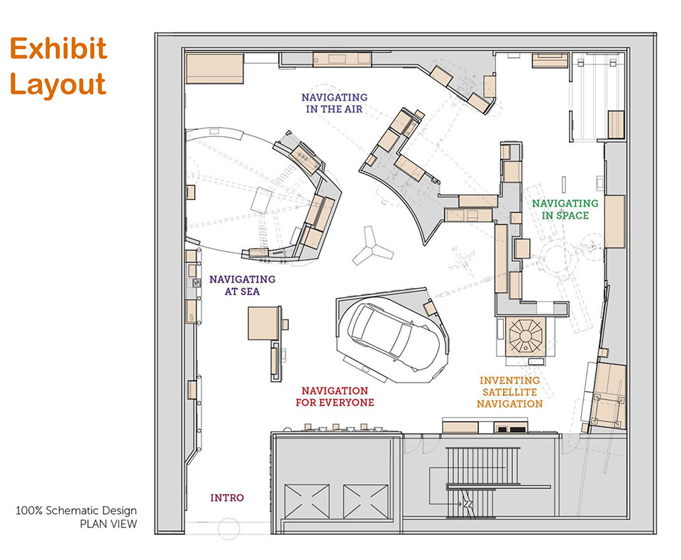
The gallery is organized into five sections and spans three centuries of efforts to travel on Earth and through the solar system. In each section the visitor will learn about pioneer navigators facing myriad issues, but one challenge always stands out: the need to know accurate time.
Sections
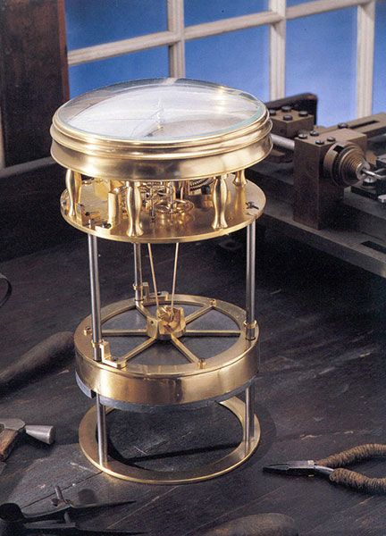
This timekeeper was the first American-made marine timekeeper taken to sea. William Cranch Bond, a 23-year-old Boston clockmaker, crafted it during the War of 1812.
Navigating at Sea is an immersive environment that suggests a walk through a 19th-century sailing vessel. Visitors will learn how centuries ago navigators at sea relied on chronometers and measurements of celestial objects to determine location. This section includes a mariner’s astrolabe, dating from 1602; a Ramsden sextant and dividing engine; several chronometers; a model of Galileo’s pendulum clock; and the earliest sea-going marine chronometer made in the United States, produced by Bostonian William Cranch Bond during the War of 1812. It also features an interactive display that allows visitors to use a sextant to navigate with the stars.
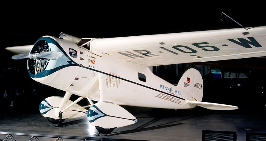
Navigating in the Air relates how air navigators struggled with greater speeds, worse weather and more cramped conditions than their sea-going predecessors. It tells the story of the innovations that overcame these challenges, as represented the gallery’s largest artifact, the Lockheed Vega “Winnie Mae,” flown by Wiley Post and Harold Gatty, shattering the around-the-world record in 1931. Visitors will learn that Charles Lindbergh required navigational tutoring after he flew to Paris and how he paved the way for a new system of navigation in the process. A personal account by a WWII navigator highlights wartime innovations. This section ends with an explanation of how clocks with tiny quartz crystals opened an entirely new era of navigation in the form of LORAN (LOng RAnge Navigation).
Wiley Post’s Winnie Mae circled the globe two times, shattering previous records. The first time was in 1931 with Weems associate Harold Gatty as lead navigator. The second was a solo flight in 1933 assisted by “Mechanical Mike,” one of the world’s first practical autopilots.
Navigating in Space traces how teams of talented engineers invented the new science of space navigation using star sightings, precise timing and radio communications. This section includes an Apollo sextant, a space shuttle star tracker, timing equipment used at a ground tracking station and a flight spare (duplicate spacecraft) of Mariner 10, the first spacecraft to reach Mercury.
Inventing Satellite Navigation describes how traveling in space inspired plans to navigate from space. Innovators found that time from precise clocks on satellites, transmitted by radio signals, could be used to determine location. The U.S. military combined several breakthroughs to create the Global Positioning System. Some of the artifacts in this section are the NIST-7 atomic clock that served as the U.S. time standard in the 1990s, the navigation system from the nuclear submarine U.S.S.Alabama, a satellite from the Transit system used for global navigation before GPS and a test satellite global navigation built at the Naval Research Laboratory.
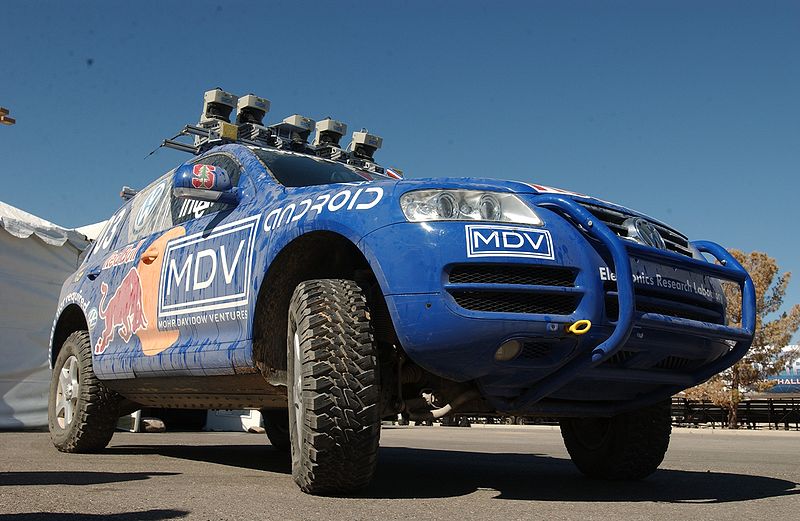
An official DARPA photograph of Stanley at the 2005 DARPA Grand Challenge. Stanley, created by the Stanford University Racing Team, won the race.
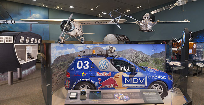
Navigation for Everyone tells the stories of real people — a fireman, a farmer and a student — who use modern navigation technology in their everyday lives. It also addresses what might come next: the story is not over yet and many new technologies are being developed. This section includes a disassembled mobile phone with a diagram showing all its parts and depicts how hundreds of years of navigation technology are now in the palm of a user’s hand. It also features “Stanley,” the robot car that won the 2005 Grand Challenge, a robot race sponsored by the Defense Advanced Research Projects Agency.
The exhibition is made possible through the support of Northrop Grumman Corporation; Exelis Inc.; Honeywell; National Geospatial-Intelligence Agency; U.S. Department of Transportation; Magellan GPS; National Coordination Office for Space-Based Positioning, Navigation and Timing; Rockwell Collins; and the Institute of Navigation.
The National Air and Space Museum building on the National Mall in Washington, D.C., is located at Sixth Street and Independence Avenue S.W. The museum’s Steven F. Udvar-Hazy Center is located in Chantilly, Va., near Washington Dulles International Airport. The National Museum of American History collects, preserves and displays American heritage in the areas of social, political, cultural, scientific and military history.
Bradford W. Parkinson, professor of Aeronautics and Astronautics Emeritus at Stanford University, discussed “GPS for Humanity — The Stealth Utility” at a special Smithsonian event Thursday, March 21. If you missed his talk, you can view it now on UStream.
According to the Smithsonian, for centuries, nations have invested enormous resources to determine time and place for geopolitical reasons, and their research has changed people’s view of the world. Advanced technology that was once available only to the military has become commonplace in car dashboards, cell phones and a growing number of other portable devices of daily life. The Time and Navigation exhibit explores how revolutions in timekeeping over three centuries have influenced how people find their way. It is organized into five sections: Navigating at Sea; Navigating in the Air; Navigating in Space; Inventing Satellite Navigation; and Navigation for Everyone.
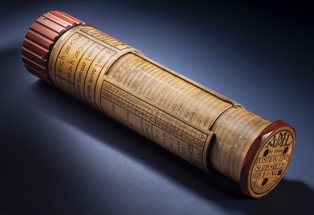
Bygrave Position-Line Slide Rule.
Andrew Johnston (geographer, Center for Earth and Planetary Studies, National Air and Space Museum) gave a presentation about the exhibit at ION GNSS in Nashville, Tennessee.
In the 1970s, Parkinson was the chief architect and original program director for GPS. In his lecture, he will present the history, applications, and future of GPS and the GNSS. Central to operation of GPS is the relationship between time and navigation, and GPS will be explored in the Time and Navigation exhibit.
Dr. Bradford W. Parkinson, professor of Aeronautics and Astronautics Emeritus at Stanford University will discuss “GPS for Humanity — The Stealth Utility” at a special Smithsonian event Thursday, March 21.
In the 1970s, Parkinson was the chief architect and original program director for GPS. In his lecture, he will present the history, applications, and future of GPS and the GNSS. Central to operation of GPS is the relationship between time and navigation, and GPS will be explored in the Time and Navigation exhibit.
Google announced on its official blog that it has released more than twenty popular U.S. museums to its collection of over 10,000 indoor maps that they launched in November: the de Young Museum in San Francisco, the Philadelphia Museum of Art, Cincinnati Museum Center, the Indianapolis Museum of Art, the American Museum of Natural History and 17 Smithsonian museums and a zoo.
American Museum of Natural History, New York City
National Air and Space Museum—Smithsonian Institution, Washington, D.C.
Google reports that to access the floor plans, simply open Google Maps on your Android phone or tablet and zoom in on the museum of interest. To find the museum, either search for it by name using the magnifying glass icon or, if you’re already there, use the “My location” feature to orient yourself. With the “My location” feature enabled you can even get indoor walking directions.
According to the announcement, more museums are adding their floor plans to Google Maps for Android soon, including the SFMOMA, The Phillips Collection, the Nelson-Atkins Museum of Art and the National WWII Museum in New Orleans. If you’re interested in getting your museum’s floor plan included in Google Maps, visit the Google Maps Floor Plans tool.