Tag: solar storm

  • How the strong solar storm could impact GNSS

    How the strong solar storm could impact GNSS

    NASA’s Solar Dynamics Observatory captured this image of solar flares on May 11, 2024. The NOAA says there have been measurable effects and impacts from the geomagnetic storm. (Photo: Solar Dynamics Observatory)
    NASA’s Solar Dynamics Observatory captured this image of solar flares on May 11, 2024. The NOAA says there have been measurable effects and impacts from the geomagnetic storm. (Photo: Solar Dynamics Observatory)

    Earth is experiencing a severe solar storm causing concern for those responsible for power grids, communication systems and satellites.

    The National Oceanic and Atmospheric Administration (NOAA) has reported measurable effects and impacts from the geomagnetic storm that has been visible as aurora across vast swathes of the Northern Hemisphere. As of May 12, 2024, NOAA had seen no reports of major damage.

    There has been some degradation and loss to communication systems that rely on high-frequency radio waves, NOAA told NPR, as well as some preliminary indications of irregularities in power systems.

    “Simply put, the power grid operators have been busy since yesterday working to keep proper, regulated current flowing without disruption,” said Shawn Dahl, service coordinator for the Space Weather Prediction Center at NOAA.

    “Satellite operators are also busy monitoring spacecraft health due to the S1-S2 storm taking place along with the severe-extreme geomagnetic storm that continues even now,” Dahl added, saying some GPS receivers have struggled to lock locations and offered incorrect positions.

    As NOAA warned, the Earth has been experiencing a G5, or “extreme,” geomagnetic storm. It is the first G5 storm to hit the planet since 2003, when a similar event temporarily knocked out power in part of Sweden and damaged electrical transformers in South Africa.

    As of May 13, NOAA’s Space Weather Prediction Center said that a G3, or “strong,” geomagnetic storm warning was in effect until 2 a.m. ET. While stronger storms are no longer likely and conditions are expected to “gradually wane” throughout the day, the center said in its forecast that moderate to strong geomagnetic storms are “likely” on May 13, as are minor storms on May 14.

    The center also said that “solar activity is expected to be at high levels” with a possibility of more solar flares, or bursts of electromagnetic radiation from the sun.

    The update came as another X-class solar flare was recorded. X-class flares are the strongest class of these solar bursts, and the latest was recorded as “moderate.”

    Flares of this magnitude are not frequent,” the center said. “…Users of high frequency (HF) radio signals may experience temporary degradation or complete loss of signal on much of the sunlit side of Earth.”

    Northern lights in unusual places

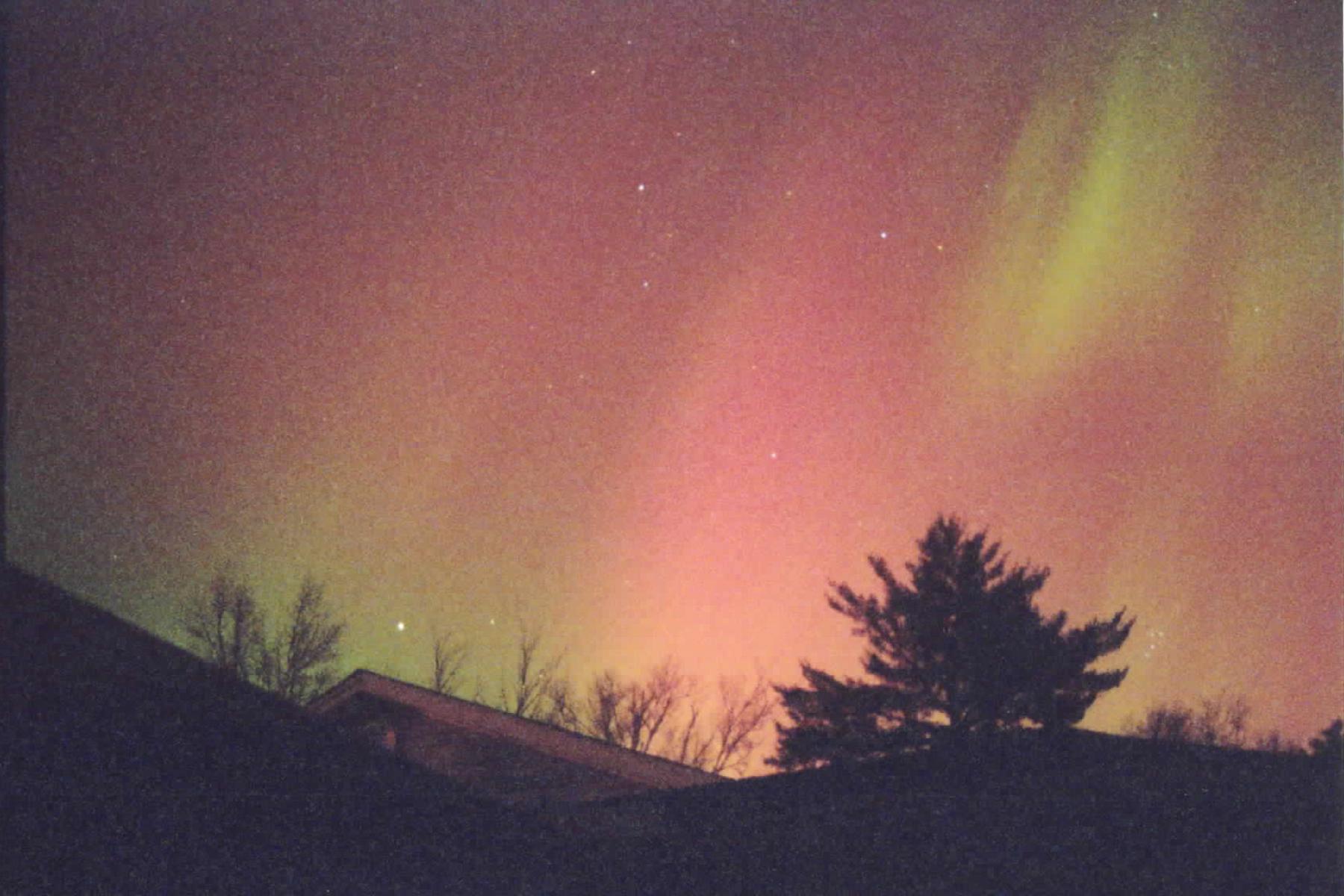
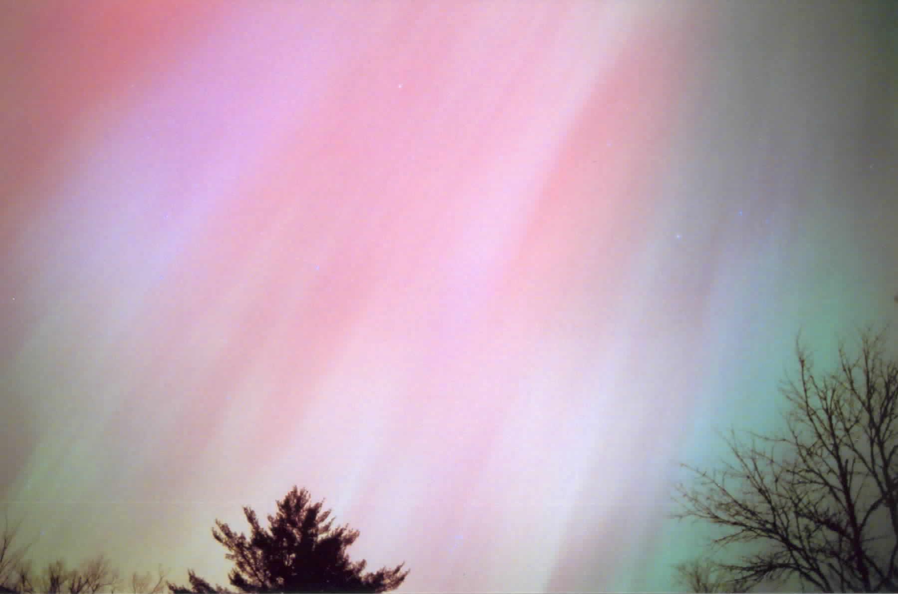
    On May 12, people from all around the world shared photos of a dazzling display of the Northern Lights, which were visible in Russia, Scandinavia, the United Kingdom, continental Europe and some even reported seeing the aura as far south as Mallorca, Spain.

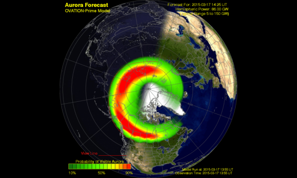
    In the United States, the NOAA center shared that the storm-induced auroras were visible as far south as Northern California and Alabama.

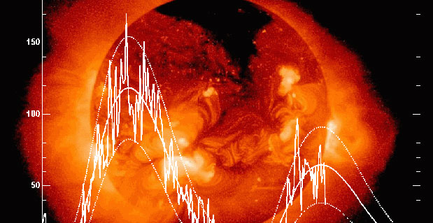
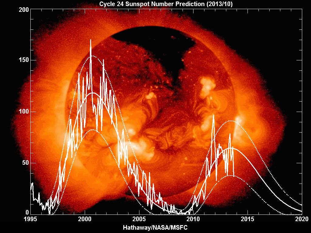
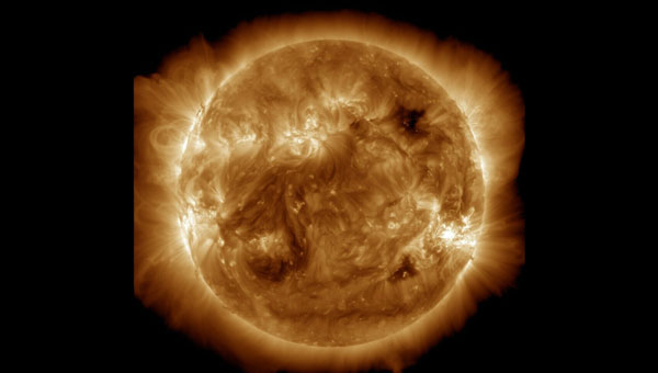
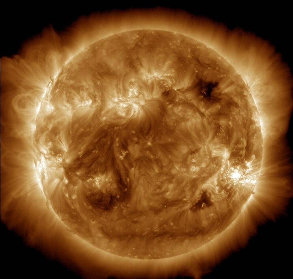
    The source of the solar storm is a cluster of sunspots on the sun’s surface that is 17 times the diameter of Earth. The spots are filled with tangled magnetic fields that can act as slingshots, throwing huge quantities of charged particles toward our planet. These events, known as coronal mass ejections, become more common during the peak of the Sun’s 11-year solar cycle.

    While the storm has proven to be large, predicting the effects of such incidents can be difficult, Dahl said.

    The world has grown more reliant on electronics and electrical systems. Depending on the orientation of the storm’s magnetic field, it could induce unexpected electrical currents in long-distance power lines. Those currents could cause safety systems to flip and trigger temporary power outages in some areas.

    The storm caused some navigational systems in tractors and other farming equipment to break down, suppliers and farmers told the New York Times.

    Farmers have become dependent on equipment that utilizes GNSS and other navigation technology to help them plant more effectively — a practice known as precision agriculture. However, some of these operations in the Midwest, as well as in other parts of the United States and Canada, came to a temporary halt.

    How it affects the ionosphere

    The storm will also likely disrupt the ionosphere, a section of Earth’s atmosphere filled with charged particles. Some long-distance radio transmissions use the ionosphere to “bounce” signals around the globe, and those signals can be disrupted.

    The particles may also refract and otherwise scramble GNSS signals, according to Rob Steenburgh, a space scientist with NOAA. Those effects can linger for a few days after the storm.

    The storms can bring on ionospheric scintillation, which refers to rapid fluctuations in GNSS signal strength and phase due to localized irregularities in the electron density of the ionosphere resulting from solar activity. Scintillation adversely affects GNSS positioning, particularly around the geomagnetic equator after local sunset.

    Similarly to Dahl, Steenburgh said that it is unclear just how bad the disruptions will be. While we still depend on GNSS, there are also more satellites in orbit. Moreover, the anomalies from the storm are constantly shifting through the ionosphere like ripples in a pool. “Outages, with any luck, should not be prolonged,” Steenburgh said.

  • GPS data release to boost space-weather science

    GPS data release to boost space-weather science

    Today, more than 16 years of space-weather data is publicly available for the first time in history. The data comes from space-weather sensors on board the nation’s GPS satellites.

    The newly available data gives researchers a treasure trove of measurements they can use to better understand how space weather works and how best to protect critical infrastructure, such as the nation’s satellites, aircraft, communications networks, navigation systems and electric power grid.

    A feature article providing an overview of the data that have been released was published today in Space Weather, a journal of the American Geophysical Union.

    “Space-weather monitoring instruments developed at Los Alamos have been fielded on GPS satellites for decades,” said Marc Kippen, program manager at Los Alamos National Laboratory in New Mexico, which developed the space weather sensors. “Today, 23 of the nation’s more than 30 on-orbit GPS satellites carry these instruments. When you multiply the number of satellites collecting data with the number of years they’ve been doing it, it totals more than 167 satellite years. It’s really an unprecedented amount of information.”

    An image illustrating the six orbital planes in which GPS satellites (“navigational satellites,” or ns) fly around Earth. This configuration shows the orbits just before the start of this solar cycle’s biggest geomagnetic storm, which occurred on March 17, 2015. The darkest orbital lines indicate the position of the satellites in that moment; the lightest lines indicate where they were 12 hours prior. (Credit: Los Alamos National Laboratory)
    An image illustrating the six orbital planes in which GPS satellites (“navigational satellites,” or ns) fly around Earth. This configuration shows the orbits just before the start of this solar cycle’s biggest geomagnetic storm, which occurred on March 17, 2015. The darkest orbital lines indicate the position of the satellites in that moment; the lightest lines indicate where they were 12 hours prior.
    (Credit: Los Alamos National Laboratory)

    Extreme space-weather events have the potential to significantly threaten safety and property on Earth, in the air, and in space.

    For example, the hazard of increased radiation exposure from charged particles released during a large solar flare could require that flights be diverted away from a polar route.

    Similarly, sudden bursts of plasma and magnetic field structures (coronal mass ejections, or CMEs) from the sun’s atmosphere and high-speed solar wind could significantly disable large portions of the electric power grid. The resulting cascading failures could disturb air traffic control, disrupt the water supply, and interfere with life-saving medical devices.

    In space, the charged particles measured by the Los Alamos-GPS sensors are the primary limit on how long a satellite can operate in space before succumbing to the damaging effects of radiation.

    In extreme events those particles can cause malfunction of satellites or even catastrophic failure of entire satellite systems.

    For example, in April 2010, a large magnetic disturbance resulted in a communications failure, causing a satellite to uncontrollably drift in space and presenting a hazard to nearby satellites.

    Currently, scientists are unable to predict when these extreme events will occur, how strong they will be, or how severe the effects will be. The release of Los Alamos-GPS data enables new studies that will help answer these questions.

    The Los Alamos-GPS sensors continuously measure the energy and intensity of charged particles, mainly electrons and protons, energized and trapped in Earth’s magnetic field. These trapped particles form the Van Allen radiation belts, which are highly dynamic—varying on time scales from minutes to decades. From GPS orbit (roughly 12,600 miles above Earth), satellite-borne sensors probe the largest radiation belt—consisting mainly of energetic electrons.

    Each of the 23 sensors in the current GPS constellation makes detailed measurements of the belts every six hours. Together the sensors provide 92 complete measurements of the belts every day. The newly released measurements constitute a nearly continuous global record of the variability in this radiation belt for the past 16 years, including how it responds to solar storms. The data provides an invaluable record for understanding radiation-belt variability that is key to developing effective space-weather forecasting models.

    Los Alamos has been anticipating greater awareness of the nation’s vulnerability to space weather since the 1990s, when it began aligning its space-weather research activities with its critical-infrastructure program. “This led to an awareness that we could expand the utility of our space-weather data to programs beyond the specific requirements they were designed for,” said Kippen, a co-author of the feature article.

    The public release of GPS energetic-particle data was conducted under the terms of an October 2016 White House Executive Order. It culminates years of work between the Office of Science and Technology Policy and the National Security Council to coordinate interagency efforts aimed at improved understanding, prediction and preparedness for potentially devastating space-weather events. The specific goal of releasing space-weather data from national-security assets such as GPS satellites is to enable broad scientific community engagement in enhancing space-weather model validation and improvements in space-weather forecasting and situational awareness.

    “The US DoD, the Office of Science Technology Policy, and the broader space weather enterprise deserve our support and thanks for this data release,” Delores Knipp, editor-in-chief of Space Weather, wrote in a blog post accompanying the feature article. “This cache of data will likely drive fundamental new developments in geospace research. The data release should be emulated by other nations as they invest in space-based global and regional navigation satellite systems.”

    The Los Alamos-GPS sensor data is hosted by the National Oceanic and Atmospheric Administration (NOAA) at https://www.ngdc.noaa.gov/stp/space-weather/satellite-data/satellite-systems/, or by searching for “GPS Energetic Particles” at https://data.gov. The sensors are supported by the Department of Energy’s National Nuclear Security Administration.

  • Bill Supports eLoran as GPS Backup

    A bi-partisan group of legislators led by Congressman John Garamendi (D-Calif.) has introduced a bill that would require the U.S. Secretary of Defense to establish a backup for GPS within three years using eLoran.

    The National Positioning, Navigation, and Timing Resilience and Security Act of 2015H.R. 1678, was co-sponsored by Congressmen Duncan Hunter (R-Calif.), Peter DeFazio (D-Ore.), and Frank LoBiondo (R-N.J). Garamendi is the ranking member of the House Transportation and uInfrastructure Subcommittee on the Coast Guard and Maritime Transportation.

    H.R. 1678 would require the secretary of defense, in coordination with the commandant of the Coast Guard and the secretary of transportation, to establish and sustain a reliable, land-based positioning and navigation system that will complement and backup America’s GPS for military and civilian uses by using eLoran.

    eLoran is the government’s existing and underused long-range navigation system infrastructure. The backup system would step in when GPS signals are corrupted, degraded, unreliable, or otherwise unavailable. A terrestrial-based system, eLoran wouldn’t be affected by atmospheric interruptions such as solar storms, or jamming or spoofing aimed at GPS.

    The bill directs the secretary of defense to incorporate the expertise and contributions of the private sector to quickly establish  system architecture, as well as build and operate the system.

    “GPS is much more than a LCD screen on your dashboard. It’s a technology used for much of our nation’s critical infrastructure and by almost every major industry in America, as well as the military, law enforcement, and first responders,” Garamendi said in a press release. “We are increasingly reliant on the precision, navigation, and timing services that GPS provides. From land navigation on cell phones to a timing source for our national infrastructure, we need a reliable backup system to GPS.”

    Garamendi said the bill would make the nation’s geopositioning infrastructure more resilient to “threats both natural and nefarious.” “A backup system could also reach places that GPS currently cannot, such as inside many buildings. This would help first responders and law enforcement more effectively protect the public,” he added.

    Other members of Congress are expected to sign on as co-sponsors after Congress returns from its spring recess, according to Dana A. Goward, president and executive director, Resilient Navigation and Timing Foundation.

    The eLoran PNT system would use enhanced long-range signals (eLoran) from 19 towers around the country, each with approximately a 1,000-mile range providing overlapping fields from which a device can derive its location. The back-up system would use the remaining Loran infrastructure and provide a secure and reliable cybersecurity insurance policy, said the press release.

    The U.S. atomic clock, accurate to one second in 300 million years, also serves as the base timing source for this backup GPS capability. This exceeds the timing needs of modern cell phones, creating an infrastructure backbone that is prepared to handle the evolution of consumer and industry electronic communications in the years ahead, the press release said.

    The bill sets out numerous requirements for the system, saying that it shall:

    • Be wireless, terrestrial, and wide area
    • Provide a precise, high-power 100 kilohertz signal
    • Be resilient and extremely difficult to disrupt or degrade
    • Be able to penetrate underground and inside buildings
    • Take full advantage of existing, unused Loran infrastructure
    • Work in concert with and complement any other similar positioning, navigation and timing systems, including eLoran.

    Since 2004, the federal government has recognized that the absence of a reliable backup system for GPS is a glaring economic and security threat to the United States, and has reaffirmed its interest in developing an eLoran as a reliable, land-based backup for GPS signals, the press release said.

    In January, the United States Army began soliciting information for eLoran receivers for the warfighter, either stand-alone or integrated with GPS, for use in Army and other Department of Defense maritime, aviation, or vehicular platforms, and for position and timing.

    The United Kingdom began using eLoran in October 2014 to protect its shipping lanes, which carry 95 percent of UK trade, in case of GPS signal loss.

  • Solar Storm Hits Earth’s Magnetic Field

    Solar Storm Hits Earth’s Magnetic Field

    A G4 (Severe) geomagnetic storm was observed today at 07/1358 UTC (09:58 am EDT). This is the response to a pair of CMEs observed leaving the Sun on 15 March. Shown here is a model depiction of where the aurora is likely visible. Storm conditions are forecast to persist for the next several hours before beginning to wane down towards the end of the UT day. (Courtesy of NOAA)
    A G4 (Severe) geomagnetic storm was observed today at 07/1358 UTC (09:58 a.m. EDT). This is the response to a pair of CMEs observed leaving the Sun on March 15. Shown here is a model depiction of where the aurora is likely visible. Storm conditions are forecast to persist for the next several hours before beginning to wane down towards the end of the UT day. (Courtesy of NOAA)

    A G4 (severe) geomagnetic storm is now taking place, the most powerful solar storm of the current solar cycle, reports Discovery.com.

    Initially triggered by the impact of a coronal mass ejection (CME) hitting our planet’s magnetosphere, a relatively mild geomagnetic storm erupted at around 04:30 UT (12:30 a.m. EDT), but it has since become a severe G4-class geomagnetic storm. Bright auroras were sighted over several northern-tier U.S. states including Minnesota, Wisconsin, Montana, the Dakotas and Washington. The storm could continue for many hours as Earth passes through the turbulent wake of the CME.

    Storm conditions are forecast to persist for the next several hours before beginning to wane down towards the end of the UT day.

    Not all types of solar activity (sun spots, solar flares, solar burst, and solar radiation) affect GPS receiver operations. Geomagnetic storms, however, can cause problems for GPS receivers if the storms are powerful enough.

    The solar cycle is about 11 years long, during which the sun waxes and wanes in magnetic activity.

    Below are ionospheric charts from Missouri, Washington State and New England.

    Missouri ionosphere chart during the March 17 geomagnetic storm.
    Missouri ionosphere chart during the March 17 geomagnetic storm.
    Washington ionosphere chart
    Washington ionosphere chart during the March 17 geomagnetic storm.
    New England ionosphere chart during the March 17 geomagnetic storm.
    New England ionosphere chart during the March 17 geomagnetic storm.
  • The Halloween Storms: When Solar Events Spooked the Skies

    The Halloween Storms: When Solar Events Spooked the Skies

    Photo: Hathaway/NASA/MSFC
    Photo: Hathaway/NASA/MSFC

    Ten years ago, scientists watching the skies experienced a Halloween fright of cosmic proportions, when space weather degraded GPS signals, affecting land and ocean surveys, and commercial and military aircraft navigation.

    The most extreme of what became known as the Halloween Storms hit on October 30, 2003 — ten years ago today. According to the National Oceanic and Atmospheric Agency, the Earth could experience a repeat performance this Halloween, with a 35 percent chance of a major storm at high latitudes.

    The U.S. Geological Survey describes the cause of the 2003 storms:

    In mid-October 2003, a bundle of concentrated magnetic energy emerged from the Sun’s interior, forming a large sunspot, a site of seething activity. Enormous solar flares soon followed.

    Then, on October 28, the sunspot abruptly ejected a concentrated mass of electrically conducting solar wind, flinging it out into interplanetary space toward the Earth. Less than a day later, on October 29, a geomagnetic storm was initiated as the solar wind disrupted the Earth’s protective magnetosphere.

    Over the next three days, the “Halloween magnetic storm” would evolve and grow to become one of the largest such storms in half a century. Magnetic storms are global phenomena, and their effects can be easily seen around the world. During the Halloween storm, for example, magnetic direction in Alaska quickly changed by more than 20 degrees. In other words, the storm was so large that it could be measured with a simple compass. The Halloween magnetic storm also produced spectacular aurora, with green phantom “northern lights” seen as far south as Texas and Florida.

    “The aurora was exciting,” said Richard Langley, GPS World’s Innovation editor. “I’ve never seen a better one since.”

    This full-sky aurora was observed near Fredericton, New Brunswick, Canada (46 degrees north latitude) on October 31, 2003. (Photo courtesy of Richard Langley.)
    This full-sky aurora was observed near Fredericton, New Brunswick, Canada (46 degrees north latitude) on October 30, 2003. (Photo courtesy of Richard Langley.)

    Langley explained the effect of the phenomenon in his introduction to the October 2004 Innovation article, “Combating the Perfect Storm: Improving Marine Differential GPS Accuracy with a Wide-Area Network.”

    It was previously thought that the mid-latitude North American ionosphere was reasonably benign, with minimal storm effects of relevance for marine DGPS users. However, during ionospheric storms in May and October, 2003, [single-frequency] marine DGPS horizontal position accuracies were degraded by factors of 10–30.These degraded accuracies persisted for hours and were well beyond system tolerances specified for marine DGPS users. Such ionospheric activity is not unusual during the years following solar maximum, and is expected to persist for several years.

    Langley provides background on what scientists learned from the Halloween Storms in his February 2011 Innovation column, “GNSS and the Ionosphere: What’s in Store for the Next Solar Maximum?”:

    The current solar cycle is referred to as cycle 24. During the last solar cycle, cycle 23, the GNSS community was alert and aware of what could happen, and therefore many events were observed and analyzed. Among the most well-known events is a sequence of storms during October and November 2003, commonly referred to as the Halloween Storms.

    The most extreme was the storm on October 30, 2003, which resulted from a CME on October 29 at 20:49 UTC, which subsequently impacted Earth’s magnetic field at 16:20 UTC on October 30 and produced a great geomagnetic storm, which lasted for many hours.

    Effects on GPS positioning of this storm have been documented by the GNSS research group of the Royal Observatory of Belgium, where kinematic analyses of data from 36 GNSS stations in Europe showed position errors of more than 10 centimeters in the horizontal and up to 26 centimeters in the vertical between 21:00 and 22:00 UTC on October 30. The position errors were largest for locations in northern Europe including Sweden and Norway. The data analysis was carried out using high-quality carrier-phase data, and the processing was based on using an ionosphere-free linear combination of observations from the L1 and L2 frequencies, whereby the first-order effect of the ionosphere is removed from the results. The position errors are thus caused by mainly higher order ionospheric effects.

    For navigation-grade GPS positioning, a U.S. National Atmospheric and Oceanic Administration technical memorandum reported that the Wide Area Augmentation System (WAAS) vertical error limit of 50 meters was exceeded for a period of about 11 hours on October 30, 2003. This means that, in practice, WAAS was not available for precision aircraft approaches during that time. The European Geostationary Navigation Overlay Service (EGNOS) was not transmitting during the storm, but simulations carried out later by ESA showed that the boundary regions of the EGNOS coverage area would have been especially affected by a reduction in service availability of about 20–60 percent during that day.

    The simulations also showed, however, that in the center of the EGNOS coverage area (in the vicinity of northern Italy), the effect would have been much smaller with a reduction in service availability of only 5–6 percent over the day.

    Such large storms are also often accompanied by displays of aurora (aurora borealis and aurora australis) at lower latitudes than normal.

    15.trimmed
    Another shot of the Halloween 2003 aurora, as seen near Fredericton, New Brunswick. (Photo courtesy of Richard Langley)

    Other Innovation columns assessing the ionosphere’s effect on GPS include:

  • Last Week’s Solar Storm and the Final LightSquared Push

    You may not have noticed it, but last Friday we experienced the first serious geomagnetic storm in this solar cycle (Solar Cycle 24), which began in 2009. Not all types of solar activity (sun spots, solar flares, solar burst, and solar radiation) affect GPS receiver operations. Geomagnetic storms are the ones that can cause problems for GPS receivers if those storms are powerful enough.

    Last Thursday, I received e-mail from Joe Kunches at NOAA (National Oceanic and Atmospheric Administration).

    “The Sun has been erupting and looks like a storm — say G3 level — could be on for Friday, August 5.”

    Joe was right, it hit about a day later, on Friday, August 5, as he predicted.

    The good news is that Joe says we generally have at least a 24-hour warning before a geomagnetic storm starts disturbing the ionosphere.

    That’s what it comes down to, the ionosphere.

    GPS signals being delayed as they pass through the ionosphere end up being the largest source of error in GPS positioning. The signals must pass through the ionosphere, which is full of free electrons. The density of these electrons in the ionosphere affects the speed at which GPS signals travel. If the density of the electrons in the ionosphere was consistent, then it would be straight-forward to create a model and largely mitigate its effects. However, that’s not always the case. The ionosphere has been relatively benign since the last solar cycle, and that’s one of the reasons that GPS accuracy has been so good, especially GPS L1 SBAS systems like WAAS/EGNOS/MSAS, which rely on modeling the ionosphere.

    The problem is geomagnetic storms. They wreak havoc on the free electrons in the ionosphere, making it difficult to accurately determine how much the GPS signals have been delayed.

    The NOAA Space Weather Prediction Center (SWPC) is one of the foremost agencies that monitors the Total Electron Count (TEC) in the ionosphere. With Joe’s help, I was able to obtain dynamic plots of the TEC from last Friday so I could illustrate to you what happened. I was also able to obtain plots from Gavin Schrock at the Washington State Reference Network (WSRN) showing how it impacted the WSRN. I compiled the plots, added some text, and produced the following Youtube video.


    As I wrote in the Youtube video, to get the most updated solar activity information that’s related to high-precision GPS users, you should follow me on Twitter at GPSGIS_Eric.

    If you’re looking for a good backgrounder on how the ionosphere affects GPS, you might want to read this April 1991 GPS World column. Although it’s dated in some respects, the fundamental concepts are solid.

    Last Push on LightSquared

    There’s been some confusion on the FCC comment period regarding the LightSquared/GPS interference issue. The comment period was not extended. The public comment period was July 1 to July 30, 2011. The reply comment period is from August 1 to August 15, 2011. However, it appears the FCC is still logging new comments even after the July 30 cut-off date. Either way, do not hesitate to submit your comments before August 15; just mark it (dropdown menu) as a reply to comments.

    This is your last chance to speak out and let your government know how important GPS is to your orgnization.

    To date, there have been more than 2,900 individual comments electronically filed as well as more than 15,000 submitted in writing to the FCC (15,000 alone from the Boat Owners Association of the United States). The vast majority of the comments support GPS.

    Some good news. On Tuesday, August 9, the FCC held an invitation-only press conference. Click here to read PC World’s summary.

    To read the 2,900+ comments submitted to date, click here; type in proceeding # 11-109 and search.

    Thanks, and see you next time.

    Follow me on Twitter at http://twitter.com/GPSGIS_Eric


  • LightSquared Saga, and Recent Solar Activity

    This week I’m following up on my article from a couple of weeks ago about the potential effects of LightSquared’s plans. As a user of high-precision GPS receivers (particularly GPS L1 sub-meter, but also dual-frequency), you should be particularly concerned about this issue. I’ll tell you why. Also, I have a note on recent the solar activity.

    LightSquared

    The reasons you should be concerned about LightSquared’s plans are two-fold:

    1. Consumer GPS receivers and professional-grade GPS receivers designed for higher performance (mapping, surveying, etc.) aren’t necessarily designed the same way. High-performance GPS receivers use a wider bandwidth radio design.

    For example, the GPS L1 frequency is 1575.42 MHz. Many high-performance GPS receivers use a wide bandwidth radio that scans +/- 20 MHz from 1575.42 MHz. That equates to a range of 1555 MHz to 1595 MHz. LightSquared’s frequency spectrum is 1525 MHz to 1559 MHz. Clearly, there’s overlap, which is another word for interference. On top of that, LightSquared plans on a broadcast strength of 1,500 watts from a tower located down the street. The GPS broadcast signal strength is about 30 watts from a satellite located some 19,000 kilometers away in outer space. Who’s going to win that battle?

    I’m not an aerospace engineer or an RF (radiofrequency) engineer, but I don’t think it takes one to see the potential impact of LightSquared’s service on high-performance GPS receivers. At the very least, it warrants an in-depth technical study.


    2. Neither the policymakers nor LightSquared know about or understand the user community of high-performance GPS receivers comprised of hundreds of thousands of high-end GPS receivers. They think the GPS user community is comprised of auto navigation and mobile-phone users. They don’t understand that we are the infrastructure people. We use GPS in a way that they don’t understand, but is so critical to our infrastructure. It’s not their fault, but you can’t assume they know, so it’s up to us to inform them. You have to speak up.

    Here’s a perfect example. Click on the following link to view a report presented by LightSquared last week in Taipei, Taiwan, at a 3GPP conference.

    “Final Report on Overload Characteristics of GPS Receivers in Proximity to LightSquared’s L-band Terrestrial Base Stations (BTS) and User Equipment (UE)”

    The best part about this report is the following statement from the Executive Summary:

    “Although results have been provided to date of a limited number of devices (6), LightSquared proposes to close the study at this stage as a more comprehensive study, covering a wider variety of GPS receivers than those involved in cellular applications, has now been initiated under the auspices of the FCC [2].  This study will be conducted by a cross-industry group led by LightSquared and USGPSIC, the reports of the study having complete public visibility.”


    Granted, I understand the Taipei conference was focused on the impact of LightSquared’s plan on mobile phones using GPS, but if this is the extent of their testing, it’s alarming. Furthermore, it’s relatively easy to acquire and operate an inexpensive consumer GPS receiver. Can you picture LightSquared attempting to test a sub-meter GPS L1 receiver or a RTK setup? GPS, GLONASS, SBAS, DGPS, real-time, post-processing, and the myriad of receivers on the market need to be tested. Although it’s likely not possible to test all equipment on the market, it’s not prudent to leave anything to chance. If, one year from now, you wake up and find out your $10,000 RTK receiver doesn’t work like it used to, it will be too late to do much about it. It takes very little time to voice your concern now to your elected officials so the appropriate attention is given to high-precision users.

    The good news is that Trimble Navigation is involved, along with the Federal Aviation Administration, with the U.S. GPS Industry Council and will be working closely with LightSquared in a Technical Working Group to better understand the impact that LightSquared’s system would have on GPS. Trimble and the FAA aren’t the only parties involved in the working group, but they are the parties that understand the needs of the high-precision user.

    The Technical Working Group’s first report is due March 15, 2011. Time is short, so don’t delay.

    Use these guidelines to take action. It is a call to action from Dr. Joe Paiva, veteran of surveying since the 1980s with whom many of you are familiar.


    Solar Activity

    As you’ve probably heard, we’re entering the next solar cycle, which is due to peak in May 2013.
    I want to periodically touch on this subject as the solar activity is going to increase over the next few years, and if the solar activity (geomagnetic storms, not sunspots) is severe enough, it will have an effect on GPS accuracy and tracking. Regardless of what you’ve heard in the mainstream media in recent months, the last event serious enough to affect GPS operations was in December 2006. That’s not to say that things aren’t heating up.
    But the recent activity does highlight the fact that “the Sun has become, somewhat suddenly, more eruptive,” according to Joe Kunches, of NOAA’s Space Weather Prediction Center. “We’ve been fortunate so far, in that the terrestrial effects — and impacts to GPS — have been very minimal. The most obvious sign of this has been the brilliant auroras up north.”
    “The video shows a large prominence eruption — billions of tons of plasma being strewn off the Sun. Some of it is drawn by gravity and rains back to the surface — the rest of it escapes. It’s the blown-away plasma that forms the coronal mass ejections that, when properly pointed, go by the Earth and cause problems for GPS,” said Kunches.
    Click on the following image to view a 15-second video of a solar flare that occured on February 24, 2011.
    Credit: NASA/GSFC/SDO

    From NASA:

    When a rather large-sized (M 3.6 class) flare occurred near the edge of the Sun, it blew out a gorgeous, waving mass of erupting plasma that swirled and twisted over a 90-minute period (Feb. 24, 2011). This event was captured in extreme ultraviolet light by NASA’s Solar Dynamics Observatory spacecraft . Some of the material blew out into space and other portions fell back to the surface. Because SDO images are super-HD, we can zoom in on the action and still see exquisite details. And using a cadence of a frame taken every 24 seconds, the sense of motion is, by all appearances, seamless. Sit back and enjoy the jaw-droppi
    ng solar show.


    March 17, 2011 Webinar: A Closer Look at L5: The Future of High-Precision GNSS

    Last year, the first GPS IIF satellite was launched. It became the first GPS satellite to broadcast the new L5 civilian signal/frequency. At 1176 MHz, it is further separated from L1 and L2 and located in the protected Aeronautical Radionavigation Services band, so there is no possibility of commercial interference like we see today with the LightSquared controversy. The availability of GPS L5 will usher in a new era of inexpensive, accurate GNSS receivers and will be the future of high-precision GNSS receivers, and quite possibly single-frequency receivers. I will also discuss the international support of L5 from other GNSS in development such as Galileo, Compass, QZSS, as well as SBAS (WAAS/EGNOS/MSAS).

    I’ll be presenting some interesting new material in the webinar such as graphics illustrating how many satellites (GPS and others) are projected to be broadcasting L1 and L5 just four years from now. It will be well worth 60 minutes of your time.


    Thanks, and see you next time.

    Follow me on Twitter at http://twitter.com/GPSGIS_Eric


  • Solar Activity and Powerpoint Presentations

    You might have heard reports this week about a solar storm this week. This is part of the new solar cycle (Solar Cycle 24) that I’ve written about several times. I want to periodically touch on this subject as the solar activity is going to increase over the next few years, and if the solar activity (geomagnetic storms, not sunspots) is severe enough, it will have an effect on GPS accuracy and tracking. Here’s the scoop on this week’s solar activity.

    First of all, I’ll let you in on a secret. I’m working on a new solar activity notification system specifically designed for GPS users. The problem is that people see reports in the mainstream media about solar activity and they automatically assume that it’s going to affect their GPS. Not all solar storms affect GPS; in fact only very specific ones (geomagnetic storms) of sufficient strength will affect GPS operations. I’m working on a notification system that will be tailored to both GPS L1 and GPS L1/L2 users (they are affected differently) so GPS users can have a reliable and specific source of information on solar activity without having to wade through the mainstream media noise.

    Stay tuned for details this fall in this newsletter to learn more about my notification system and how to and access it. If you’ve ever used some of the GPS hardware/software products I helped design, you know my top priority is to make it easy to use and understandable.

    This week’s event was probably the strongest geomagnetic storm of this solar cycle and of recent years (edit: actually, the storm in early April 2010 was a little stronger), maybe since late 2006. It will create some beautiful “northern lights,” but as strong as that may seem, it still wasn’t strong enough to elicit even a “cautionary” warning to GPS users (neither GPS L1 nor GPS L1/L2).


    NASA video of sun’s activity on August 2, 2010


    The last geomagnetic storm that adversely affected GPS users was in December 2006. It affected some GPS users for 10-15 minutes. For such a short time, most users would not notice or they might attribute it to a local system malfunction. By the time they investigate and reset the system, the event has passed and the user is back in operation. It was barely noticeable, if at all.

    On the other hand, a severe geomagnetic storm such as the one that occurred in October 2003 can last for days and wreak havoc on precision GPS receivers. During extreme geomagnetic storms like that one, GPS accuracy suffers a lot, especially with GPS L1 users. During that event, simulations from the University of Calgary showed that WAAS maximum horizontal error (95th percentile) reached 25 meters while single baseline DGPS maximum horizontal error (95th percentile) reached 18 meters.

    Dual-frequency users aren’t affected as much by extreme events but aren’t immune. Extreme events such as October 2003 can cause a loss of phase lock, especially with L2 on receivers that utilizing codeless and semicodeless techniques, which are virtually all of the dual-frequency GPS receivers on the market as of today.

    For GPS users, nothing can be done to mitigate the effects of a strong geomagnetic storm. The next best step is to try to predict when they will occur so GPS users know what to expect. Fortunately, these storms are not common and scientists can reasonably predict when an event will occur.

    There are some good websites to reference when checking up on solar activity. A great place for Europeans to do this is at the Royal Meteorological Institute of Belgium’s website. The U.S. National Weather Service also operates the Space Weather Prediction Center. The Australian Space Weather Agency operates a Space Weather Prediction Center, too. Also, note that for those users along the equator and at higher latitudes, your area is more susceptible to stronger geomagnetic storm activity.

    The websites listed above are chock full of information and predictive systems on space weather. In fact, I believe it’s too much information for most GPS users to efficiently interpret. The goal with my new initiative is to provide GPS users with a quick summary so they are able to make informed decisions in a few seconds. Again, stay tuned this fall for the rollout.


    Conference/Webinar Presentations

    Between webinars and conferences, I’ve put together a fair number of Powerpoint presentations. I’m in the process of uploading many of them, some dating back years, to our website. Currently, I’ve uploaded ones that date back to April 2010. I hope you enjoy them.

    The following presentations have all been converted to PDF format and are copyrighted. Feel free to incorporate them (or parts of them) into your documents if you like, just please remember to attribute each page you use to my name, Eric Gakstatter, and GPS World/Geospatial Solutions.


    2010 (July San Diego, California) ESRI Surveying and Engineering GIS Summit luncheon keynote presentation: Get It Surveyed (GIS).


    2010 (June, Seattle, Washington) Asia-Pacific Economic Cooperation meeting: Mapping and Surveying with SBAS+GPS.


    2010 (June, Portland, Oregon) Webinar: GIS Mapping for Forestry, Agriculture, and Other Natural Resource Professionals.

    Note that for the following webinar, you can also download an audio portion of the webinar free of charge by clicking here.


    2010 (April, Portland, Oregon) Webinar: GPS, GLONASS, and SBAS Constellation Updates.

    Note that for the following webinar, you can also download an audio portion of the webinar free of charge by clicking here.


    2010 (April, Phoenix, Arizona) ACSM Annual Conference: GNSS Technology Update.


    2010 (April, Phoenix, Arizona) GITA Annual Conference: How the Evolution of GPS is Transforming Surveying and Mapping (along with Pamela Fromhertz of NGS).

    Part 1 – GNSS Mapping/Surveying Technology Update


    2010 (April, Phoenix, Arizona) GITA Annual Conference: How the Evolution of GPS is Transforming Surveying and Mapping (along with Pamela Fromhertz of NGS).

    Part 2 – Machine Control Using GNSS


    2010 (April, Phoenix, Arizona) GITA Annual Conference: How the Evolution of GPS is Transforming Surveying and Mapping (along with Pamela Fromhertz of NGS).

    Part 3 – Sub-Meter Mapping Using GPS


    2010 (April, Phoenix, Arizona) GITA Annual Conference: How the Evolution of GPS is Transforming Surveying and Mapping (along with Pamela Fromhertz of NGS).

    Part 4 – Low-Cost GPS Receivers for GIS Mapping

    Thanks, and see you next time.

    Follow me on Twitter at http://twitter.com/GPSGIS_Eric

  • Solar Activity and RFID Technology

    Updated: Friday, April 9 11:00am US Pacific. I added more specific information regarding signing up for Space Weather Prediction Center email alerts. See below.


    It’s time to touch on the solar activity subject again, as there was an event earlier this week and rumors began to fly. The mainstream press jumped on a story back in January when the first solar flare of Solar Cycle 24 occurred. Of course, journalists were writing about worst-case scenarios in the event of extreme solar events that could cause power grids to fail, GPS to stop working, etc.

    While that is true, it’s a real stretch and the typical “sky is falling” reporting. In reality, the solar flare back in January had no effect on GPS operations. In fact, it would take an event 10-20 times stronger than last January’s to begin to notice any effect on GPS operations. Earlier this week (Monday 0800 GMT), the first geomagnetic storm of Solar Cycle 24 occurred.

    Geomagnetic storms are the ones that will give GPS users problems, although this one didn’t because it was relatively minor. The last geomagnetic storm strong enough to noticeably affect GPS users occurred in December 2006. During such an event, it might interrupt your GPS receiver for 10-15 minutes. Most users would not notice or they might attribute it to a local system malfunction. By the time they investigate and reset the system, the event would have passed and the user is back in operation. It would be barely noticeable, if at all.

    According to Joe Kunches of the NOAA Space Weather Prediction Center, a geomagnetic storm is a global event (as opposed to a regional event) that is caused by a highly energized solar wind that is fast and embedded with a strong magnetic field. In the following chart, you can see how this week’s event illustrates this.

    Source: NOAA Space Weather Prediction Center

    In the above chart, the top panel illustrates how the magnetic field becomes much more turbulent starting at 0700 GMT. The fourth panel on the chart denotes the solar wind speed, which ramped up to approximately 2,000,000 mph (3,218,688 kph) at its peak.


    Extreme geomagnetic storms = Dynamic TEC = GPS interruptions

    There needs to be very turbulent solar wind that disturbs the Earth’s geomagnetic field in order for GPS operations to be affected. For those of you who are familiar with the Total Electron Count (TEC), a dynamic TEC density in the ionosphere is what really messes up GPS operations. If the TEC is stable, the ionospheric models work fine and we get really good GPS performance like we’ve seen in the past few years in between solar cycles.

    GPS L1 users are affected most by a dynamic TEC density in the ionosphere. These are users of WAAS, DGPS, and commercial L1 correction services like OmniSTAR VBS (not their XP or HP service). During the extreme geomagnetic event in October 2003, published simulations (Yousuf, Skone, Coster, University of Calgary, ION NTM 2005) that illustrated the WAAS maximum horizontal error (95th percentile) blew out to 25 meters while single baseline DGPS maximum horizontal error (95th percentile) blew out to 18 meters. This extreme event lasted for several days.

    This doesn’t mean you’re going to have major problems in the future if you are using WAAS (or another SBAS) or DGPS, but just that high-performance GPS L1 receivers are the most susceptible to extreme solar events. In the case of the December 2006 event, SBAS and DGPS users might have experienced 10-15 minutes of unusual behavior depending on their locations. According to Kunches, high latitude geographic regions (60+ degrees latitude) and the region within 10 degrees of the geomagnetic equator (as opposed to the geographic equator) are affected the most by geomagnetic storms.

    GPS L1/L2 receivers are less susceptible to extreme solar events because they can actively model the affects of the ionosphere, but they are not immune. Extreme events such as in October 2003 can cause a loss of phase lock, especially on L2 with GPS receivers that utilize codeless/semicodeless techniques, which are virtually all of the dual-frequency GPS receivers on the market today. The L2 signal-to-noise (SNR) ratio on L2 is quite a bit lower due to the codeless/semicodeless technique so it is more susceptible.

    GPS L1/L2 receivers using L2C will be less affected (assuming a sufficient number of GPS satellites are broadcasting L2C) due to a stronger SNR.


    Not the time to panic

    The reason I wrote this article is to share what I’ve learned about the effects of solar storms on GPS operations from speaking with a number of different scientists. This isn’t meant to be a warning of impending doom for GPS users or anything or that sort. Extreme events typically occur near the solar peak and then again during the decline of the cycle. The peak is estimated to occur around May 2013, so the typical extreme events affecting GPS would likely occur in 2013, 2014, and 2015. It’s too early to start worrying much about it now.

    However, as Solar Cycle 24 ramps up, we’ll see more and more geomagnetic storm activity. If you’re a high-performance GPS user (meter or sub-meter level GPS L1 and GPS L1/L2), I think it’s a good idea to monitor space weather now. Fortunately, the NOAA Space Weather Prediction Center (where Kunches works) provides a service that will notify you of unusual space weather by e-mail. You can sign up to receive e-mail alerts at http://www.swpc.noaa.gov

    Following are detailed instructions for signing up for alerts:

    -Goto the Space Weather Prediction Center website.

    -Click on Email products (under the Support Services menu on the left)

    -Create an account if you don’t have one already (it’s free).

    -Click on Subscribe

    You don’t want to subscribe to everything. Here are the ones specific for GPS operations:

    -Advisories/Space Weather Bulletin

    -Geomagnetic Storm Products/(sign up for both Alerts and Warnings for K6, K7, K8, K9 events.

    -For high latitude (55 degrees and higher) users, also sign up for Alerts and Warnings for K4 and K5 events.


    Following are some good reference links regarding the Solar Cycle and TEC:

    GPS World article in January 2010 (scroll to end of article)

    GPS World article in October 2009 (follow-up to other October 2009 article)

    GPS World article in October 2009

    GPS World article in May 2003

    Latest NOAA prediction on Solar Cycle 24

    Solar Cycle 24 page

    Real-time TEC plot from the Jet Propulsion Lab

    Wikipedia description of the Ionosphere

    Wikipedia description of the Total Electron Content (TEC)


    RF ID (Radio frequency Identification) in Survey Monuments

    If you haven’t been followi
    ng my Geospatial Solutions Weekly newsletter (sign up here for free), you might want to sign up and read the article I wrote on how RF ID is going to be a technology very much used by surveyors in the future. You can read the article by clicking here.


    Webinar later this month (April 22, 10 a.m. Pacific time, 6 p.m. GMT): GPS, GLONASS, and SBAS Constellation Updates

    There’s been a lot of infrastructure changes with GPS, GLONASS, and SBAS in the past six months. We’ve already got several hundred people registered for this webinar. It’s going to be a good one. Here are some of the questions I’ve received already and will be addressing:

    1. When and where will the new FAA WAAS GPS Satellite cover?
    2. Will the accuracy of hand-held units be increased with these latest changes?
    3. What developments will make GPS & GLONASS work better together? In terms of RTK accuracy.

    There have been some questions as to whether you can receive continuing education credit (PDH, CEUs, etc.) by attending the webinar. Please e-mail me directly with these requests and I will do my best to accomodate.


    See you next time.

    Follow me on Twitter at http://twitter.com/GPSGIS_Eric