Tag: solar

  • Percepto launches drone with advanced AI analytics

    Percepto launches drone with advanced AI analytics

    Percepto Air Mobile drone with base. (Photo: Percepto)
    Percepto Air Mobile drone with base. (Photo: Percepto)

    Percepto, an Israel-based company specializing in autonomous inspection with industrial robotics, has launched its 2022 Autonomous Inspection & Monitoring (AIM) platform and Air Mobile drone.

    Recently listed in TIME magazine’s 100 Best Inventions of 2021, Percepto offers an end-to-end solution powered by artificial intelligence (AI) to collate and streamline all visual data for accurate actionable insights.

    Percepto AIM 2022 has a new Insight Manager to deliver AI-powered packaged solutions for sector-specific use cases, such as solar, mining, energy, oil and gas and other industries. The company drew on tens of thousands of hours collected by autonomous robot missions at industrial facilities to create it.

    Percepto’s AI change-detection framework offers unified visual data and critical business insights for each of the sector-specific solutions. AIM 2022 can be integrated with autonomous drones and robots as well as other visual data collectors, now including DJI drones, and fixed cameras.

    Reports and insights are automatically generated based on the combined visual data. Disseminated to relevant stakeholders on any mobile device, issues and faults are geotagged and displayed on a map, enabling effective action before escalating into more serious problems.

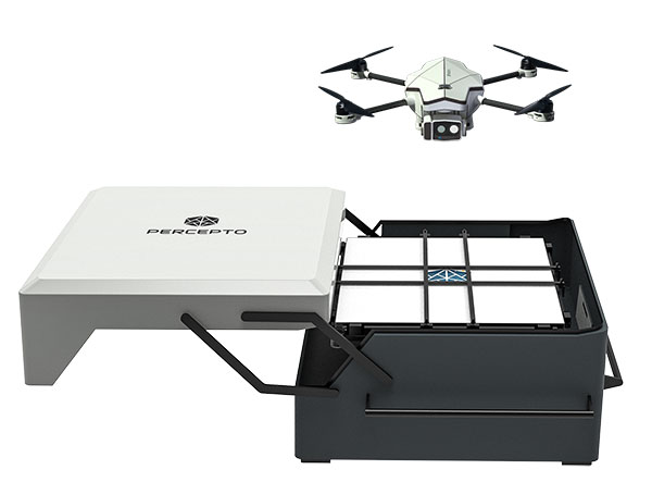
    Percepto also introduced its new Percepto Air portfolio to support the enhanced platform, which will address the diverse needs and increasing demands of various markets.

    Percepto Air Max. The next generation of Percepto Sparrow, the Percepto Air Max is a field-proven solution that operates in the largest mining, oil and gas, and energy companies on six continents. It has a top-grade, versatile payload for specific use cases. Designed to inspect and map complex industrial environments where the highest accuracy and durability are critical, Air Max also has an optical gas imaging (OGI) camera.

    Percepto Air Mobile. This option is a more compact and lighter weight model for smaller sites or organizations taking their first steps with a drone-in-the-box program, or larger sites that need greater deployment flexibility. It is designed for linear inspections, such as pipelines and power lines, and can monitor short-term projects across multiple sites, such as construction sites.

    Percepto Air Max and Air Mobile drones are stored permanently onsite within their respective Percepto Bases. The Air Mobile’s base is light and easy to relocate while maintaining high levels of durability. These encasements are designed for infrequent maintenance and protection against extreme environmental phenomena, such as hurricanes. Percepto’s drones are safe and regulation ready, and ensure all operational aspects meet corporate standards.

    “Percepto AIM 2022 and the new Percepto Air line of drones, together with the most advanced change detection solution, alert and prevent failures and downtime within diverse use cases across many industries,” said Percepto CEO Dor Abuhasira. “Percepto AIM provides the most advanced and comprehensive enterprise inspection software that offers a complete data workflow — from capture to insight. With Percepto Air Max and Percepto Air Mobile, companies have a range of options to choose from depending on the size of their facilities and the flexibility needed to deploy drones.”

    “The real power of Percepto’s system is how data collection and analytics are integrated for a holistic view from both a technical and management perspective,” said Tim Shanfelt, director of Operations Transformation, Koch Ag & Energy. “Our workers are connected to high-level information that helps them make the right decisions while keeping them safe and free to pursue higher value activities. Our goal is to eliminate hazardous, wasteful, and mundane tasks from our operators’ day. For example, instead of an employee climbing an icy ladder in the winter, a robot or drone can perform the same task while still obtaining accurate measurements. We see Percepto playing a significant role in helping make our facilities more safe, secure, efficient, and profitable.”

  • Nearmap acquires Pushpin tech for roof geometry

    Nearmap acquires Pushpin tech for roof geometry

    Figure 2: Rapid growth requires frequent imagery. Above is a new Durham neighborhood under construction. (Photo: Nearmap)
    Photo: Nearmap

    Aerial imagery company Nearmap has acquired technology and assets from Pushpin, a deep learning and analytics technology company that extracts data from 3D models to provide roof geometry insights to a variety of sectors including roofing, solar and government.

    The technology acquisition allows Nearmap to rapidly extract and disseminate roof geometry from its wide-scale 3D models and offer a new form of location content to its customers.

    ‘‘By acquiring Pushpin’s 3D geometry extraction technology and pairing it with our rich data, we bring the best of both worlds together at unprecedented scale’’ said Rob Newman, Nearmap CEO. “Over the past couple of years, we’ve evolved our offering from 2D imagery to a multi-product portfolio, and this acquisition is an important milestone in our approach to continue adding new content types for our customers. This addition aides our company mission by providing 3D geometry data at unmatched speed, thereby changing the way our customers perform their work.”

    With this new technology, Nearmap can provide a semi-automated calculation and extracted representation of any roof geometry within an hour, significantly reducing turnaround time. The combination of Nearmap’s 3D content and Pushpin’s geometry extraction technology opens up a diverse range of use cases, enabling businesses to fast-track job estimation, determine solar irradiance, plan drone delivery routes and model 5G propagation.

    “The addition of Pushpin’s 3D geometry extraction technology into our large-scale 3D reality models will enable us to further evolve our offering and produce at scale roofing geometry,” said Tom Celinski, Executive Vice President, Technology and Engineering at Nearmap. “With the added ability to provide roof geometry data, we will be able to provide even deeper insights on what’s happening on the ground, and help businesses and government organizations transform the way they work and do their job more efficiently.”

    The roofing and solar industries are poised for significant growth. Currently, 1% of the United States population has solar panels on their homes. According to the Solar Energy Industry Association (SEIA), total U.S. solar capacity will more than double over the next 5 years.

    Additionally, a significant number of U.S. residential homes have their roofs replaced every year due to roof damaging storms and changes in roofing trends and material. This new product offering from Nearmap is poised to significantly impact these markets, as companies are expanding their use of technology to assist with tasks such as roof material and project quoting through reports, project management through roofing specific software, and customized sales and marketing tools for the roofing industry.

  • Nearmap introduces roof pitch and area tools for solar and roofing

    Nearmap introduces roof pitch and area tools for solar and roofing

    Nearmap high-resolution aerial image showcasing new toolset in MapBrowser, captured Sept. 15, 2018. (Image: Nearmap)
    Nearmap high-resolution aerial image showcasing new toolset in MapBrowser, captured Sept. 15, 2018. (Image: Nearmap)

    Nearmap has introduced a complete measurement toolset in MapBrowser for the solar, roofing and other rooftop industries.

    The new tools allow users to measure roof-pitch, height, width and area, enabling roofers and solar installers to confidently measure rooftops and structures from high-resolution oblique aerial images, the company said.

    The new MapBrowser helps customers significantly reduce onsite visits during the quoting and planning stages of projects and complements their remote roof/site inspection workflows, giving many small businesses the power of expensive systems that only large companies use.

    “Gone are the days of climbing on roofs to take measurements,” said Tony Agresta, executive vice president of product at Nearmap. “Delivered to the cloud within days of capture, our aerial imagery allows roofers, solar companies and other small businesses to carry out assessments from the comfort of their office. Once the domain of large companies, the new features provide businesses of all shapes and sizes with the tools they need to save time, plan and estimate more accurately at a fraction of the price.”

    Using Nearmap’s new tools, roofers and solar companies will be able to:

    • Prospect more efficiently by viewing and expanding opportunities through aerial maps instead of other, more traditional ways.
    • Process leads more quickly by qualifying prospects prior to visiting a potential job.
      Reduce costs associated with the qualification and proposal stages.
    • Create better proposals using up-to-date, high-resolution photos, giving companies a better chance at winning a client’s business.
    • Close more sales with the most accurate and competitive quotes.
      Increase revenue without adding systems or headcount.

    Businesses in construction, home building, painting, insurance and other industries can also benefit from these new tools to accurately measure areas on properties in three dimensions. Nearmap’s aerial imagery can help users to show context for work being done, and the imagery can be annotated with notes, drawings and measurements that provide details of the plan.

    Nearmap Oblique imagery can be accessed through a standard web browser using Nearmap’s intuitive MapBrowser application. In addition, Nearmap Oblique photos are published at sub-7.5cm ground sampling distance (GSD) — better than satellite imagery — which allows users to see great detail, Nearmap said.