The South African National Space Agency (SANSA) launched the South Africa Space Weather Center at Hermanus in November to provide real-time space weather forecasts. The space weather center detects space weather conditions such as strong solar flares that could disturb Earth’s magnetic field and severely affect ground-based electrical and electronic systems.
The space weather center collects data in real-time from solar satellites and a ground-based instrumentation network which consists of three kinds of sensors: GNSS receivers, magnetometers and an ionosonde system. Space weather conditions are then broadcast to South Africa and the rest of the continent to provide critical 24/7 space weather alerts for airlines, air traffic control agencies, telecommunications companies and satellite operators.
The International Civil Aviation Organization now recognizes the space weather center, as the launch filled the void in global space weather monitoring and 24/7 forecasting coverage.
SANSA received approval for the space weather center in 2019 and overcame many challenges during its development, such as limited funding for research, personnel, and equipment, as well as the COVID-19 pandemic.
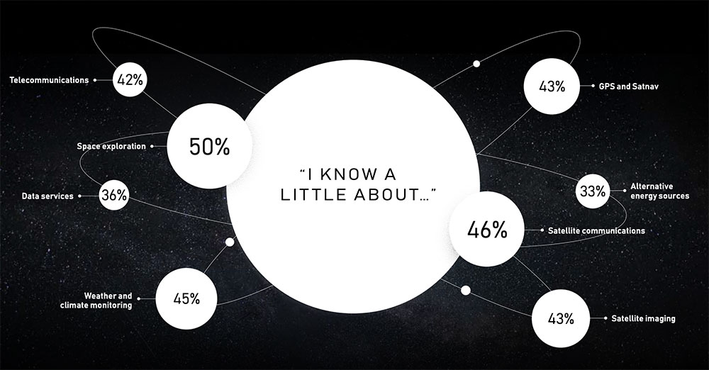
The satellite company spoke to 20,000 people in 11 countries across the globe to uncover their perceptions of space, what happens “up there” and how they think it impacts life here on Earth.
The survey found that most people have no idea about the benefits of space. Only one third are excited about space, with 47% concerned about space junk and just 8% associating space with communications and connectivity.
Just 8% of respondents associate space with communications and connectivity.
“From connecting rural communities to helping solve climate change, we know the enormous potential space holds to improve life on Earth, and what it has already brought us,” Inmarsat said in a statement. “Now, both the magnificent possibilities and the potential risks of space, which Inmarsat is working hard to address, need to be showcased to the world.”
The report also features contributions from renowned figures in the sector including Scott Kelly, former astronaut and commander of the International Space Station, and Josef Aschbacher, director general of the European Space Agency.
“The research findings mark a real wake-up call for the space industry,” Inmarsat said. “It’s clear that people have a low understanding of the breadth and richness of the work being done in space today. Perhaps because the technology deployed is essentially invisible, people do not appear to understand the role space is already playing in their everyday lives, nor its potential to deliver a brighter future for our planet.”
EUSPA’s mission is to link space to user needs. Over the past year, EUSPA has increased access to EU space data and services around the world, launched new Galileo satellites, and put in place additional satellite navigation services.
EUSPA operates Europe’s satellite navigation systems Galileo and EGNOS. It is also the gatekeeper to a secure EU Space Programme, providing end users with the confidence of knowing that the space-derived data they depend on is safe and secure.
The agency plays a central role in the market uptake of the data and services offered by the EU Space Programme components. EUSPA also manages the development of GOVSATCOM hubs, which will provide secure, cost-efficient communication capabilities to security and safety-critical governmental missions, operations and infrastructure.
the entry into service of a new Galileo satellite for additional accuracy to end-users
publishing the EO and GNSS Market Report, a comprehensive market intelligence study providing trends for the entrepreneurs and investors.
3.1 billion Galileo-enabled smartphones sold globally since 2016.
“I am more than proud of what EUSPA has achieved in a year. I am also proud to be at the helm of an organization staffed with dedicated professionals, with a service-oriented mindset who work to make EU Space accessible to citizens,’’ said Rodrigo da Costa, EUSPA executive director. “EUSPA remains committed to helping the union and its citizens maximize the socio-economic benefits of space.”
Emcore Corporation has entered into a definitive agreement to acquire the assets and liabilities of the L3Harris Space and Navigation business for approximately $5 million in an all-cash transaction.
“L3Harris Space and Navigation designs and builds some of the most accurate navigation products in the world,” said Jeff Rittichier, president and CEO of Emcore. “This acquisition expands our fiber-optic gyroscope (FOG) product portfolio into the strategic grade and space-qualified markets. We will also gain a technical team with a sterling track record of development and production of high-performance FOGs, ring laser gyros (RLGs) and reaction wheels.
“This acquisition further solidifies Emcore’s position as one of the largest independent inertial navigation providers in the industry. This is an excellent fit strategically for Emcore, bringing space and navigation’s strong brand, inertial technology and important program wins. It also expands Emcore’s market reach into launch vehicle and space satellite markets, both of which are seeing significant growth,” Rittichier added.
“The L3Harris Space and Navigation team will provide Emcore with the capability to accelerate expansion into a true navigation-grade FOG business with superior performance and accuracy compared to competitors,” said Albert Lu, senior vice president and general manager, Aerospace and Defense for Emcore. “Combining this business into Emcore will allow us to provide customers with an expanded product suite that serves a broader range of requirements across both the tactical and navigation grade segments of the market.”
Highlights of the transaction are as follows:
Expands Emcore’s inertial navigation product portfolio and addressable market, accelerating growth and contributing additional revenue.
Includes master supply agreements (MSAs) for the BoRG (Booster Rate Gyro) and TAIMU (Tri-Axial Inertial Measurement Unit) launch vehicle programs and creates partnership opportunities with L3Harris to expand mutual business.
Adds Emcore as a preferred supplier to L3Harris divisions for future business opportunities.
Adds a complete set of capabilities to design and test for space applications:
shock, vibration and thermal-shock measurement equipment
x-ray capability and vacuum chambers.
Includes a large number of rate tables that can serve multiple product applications.
Is expected to create material operating synergies in engineering, manufacturing and sales.
Is expected to be non-GAAP EPS accretive.
Through the transaction, Emcore will acquire all the intellectual property and outstanding assets and liabilities of the L3Harris Space and Navigation business, including the 110,000-square-foot leased production facility in Budd Lake, New Jersey.
The consummation of the transaction is subject to customary closing conditions and is currently expected to close in the quarter ending June 30, 2022.
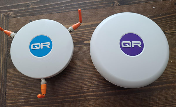
The QR100 and QR201 anti-jamming devices. (Photo: Quantum Reversal)
Quantum Reversal has added several new models to its flagship anti-jamming line. The company introduced in February the QR100 L1/L2 GPS anti-jamming unit and the QR101 L1/L2 GPS anti-jamming antenna.
The current solution consists now of five products designed for the commercial market to solve the issue of unintentional RF interference or jamming:
QR100 – GPS dual frequency L1/L2 anti-jamming unit
QR200 – GPS dual frequency L1/L2 anti-jamming antenna
QR101 – GNSS multi frequency bands anti-jamming unit
QR201 – GNSS multi frequency bands anti-jamming antenna
QR202 – GNSS multi frequency band anti-jamming antenna with additional L-band reception
(1520-1560 MHz)
All models provide robust GPS or GNSS navigation solution, blocking intentional jamming and unintentional RF interference for services such as timing or 3D positioning.
All the products are lightweight (230 grams for QR1xx series and 500 grams for QR2xx series) with low power consumption (1-1.5 Watt typically, depending on the configuration), and can be mounted on any platform (cars, poles, drones, etc.).
Quantum Reversal operates in the information and wireless technology sector, developing innovative wireless and antenna technologies for various commercial markets. The QR team has experience designing products for applications in space, underwater, robotics and unmanned aerial vehicles (UAVs) for the commercial and user end. Each application requires a specific solution to deal with specific environmental (pressure, temperature, vibration, etc.) and operational conditions.
The company sells stand alone products as well as OEM products that can be integrated within the customer products.
Sensonor has launched two new navigation devices. The high-accuracy tactical-grade STIM277H gyro module and STIM377H inertial measurement unit (IMU) are based on experiences and requirements from serving customers in the space segment during the past decade.
The modules have a hermetic aluminum enclosure with a glass-to-metal sealed electrical micro-d connector and a laser-welded lid to secure long-term hermetic operation.
All parts are tested for fine and gross leak to conform to MIL-STD-883J, Class H. The hermetic enclosure protects the system from the external environment and ensures long-term reliability to meet requirements within the space segment and other applications needing exceptional long-term reliability.
The design is tested for a 20+ years’ operating life through high-temperature operating life (HTOL) testing. STIM277H and STIM377H are electrically and mechanically backward-compatible with Sensonor’s other IMU and gyro modules, and provide users with an easy implementation into an existing design.
The components come in dust-free clean-room packaging and have SurTec650 as the only surface treatment. The components are International Traffic in Arms Regulations (ITAR)-free, and have a range of features that can be configured by the customer.
While the new part is still a commercial off-the-shelf (COTS) product and not space-qualified, Sensonor has carried out extensive radiation characterizations to understand the capability of the parts. This data is available on request from Sensonor or can be downloaded.
The parts are a good fit for satellite attitude and orbit control systems (AOCS), launchers, portable target acquisition systems, UAV payloads, land navigation systems, turret stabilization, missile stability and GNSS-supported navigation systems.
To explore new investment support for the European space-based economy, the EIB and GSA are bringing together their expertise and experience. The common objective is to create high-skill jobs in the EU and improve the day-to-day lives of Europeans by supporting innovative companies and accelerating the development of new applications that use European global navigation satellite systems and earth observation data. These applications could be used to ensure smooth navigation, such as in search-and-rescue operations to save lives, for observing crops, and in precision farming to reduce the need for fertilizers and pesticides.
“Space is the final frontier, and there is a new worldwide ambition in reaching it. The EU’s global competitors and new private actors are investing heavily in the space sector. At the same time, new disruptive technologies and business models are emerging and changing the playing field,” said EIB Vice-President Ambroise Fayolle, who is responsible for innovation. “We need to make sure that Europe stays in the game. That is why we are particularly enthusiastic about this agreement with GSA. It is an important step to develop further support for European space entrepreneurs and businesses to eventually give them and the EU a competitive edge in this new space race.”
“Our expertise in market intelligence for satellite navigation and in supporting new business opportunities — thanks to EGNOS and Galileo — is the basis of our agreement with the EIB,” said Carlo des Dorides, GSA Executive Director. “We are confident that our cooperation will bring the extra added value required by entrepreneurs to transform their application businesses into globally successful companies.”
A changing space sector
The global space economy has been evolving rapidly in recent years. On average it has grown by 6.7% per year over the last 10 years, which is almost twice the 3.5% average yearly growth of the global economy. This growth has been partially driven by the US, China and other countries that have developed new ambitious space missions.
The main driver, however, has been the “New Space” phenomenon: a number of technological and business model innovations that have introduced new products and services and reduced the cost of accessing and using space.
The transformation of the space economy has seen new space companies investing over EUR 14.8 billion since 2000, with a fast accelerating trend: total investment in space companies grew by a factor of 3.5 in 2012–2017 compared with the previous six-year period. Moreover, US-based investors dominate the field accounting for around two thirds of the 400+ worldwide investors in space companies.
Historically, Europe has always been at the forefront of publicly-funded space exploration, investing massively in space infrastructures such as the Copernicus and Galileo satellite programmes. Europe still boasts academic and scientific excellence but risks missing the next wave of space innovation unless it seizes the opportunity to stimulate more private investment in the new space sector.
According to a recent EIB and European Commission study on the future of the European space sector, European space entrepreneurs feel there is a lack of private financing sources, particularly for late-stage investments. They therefore tend to keep an eye on private capital outside the EU, especially in the US.
In this context, European public innovation instruments play an essential role in unlocking private capital for the space sector. 40% of the European companies surveyed seek public funding, which serves as a seal of approval in the market, as a precondition for further private investment.
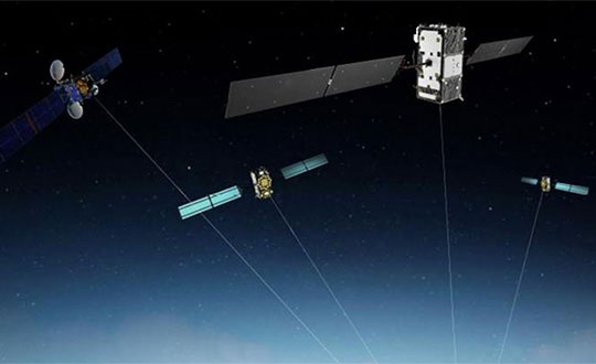
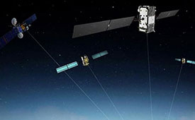
The European Space Agency (ESA) and the U.S. National Aeronautics and Space Administration (NASA) are conducting a joint GPS/Galileo space receiver experiment onboard the International Space Station (ISS). This will be the first time that a combined GPS/Galileo receiver will operate in space.
The project aims to demonstrate the robustness of a combined GPS/Galileo waveform uploaded to NfASA hardware already operating in the challenging space environment: the Space Communications and Navigation (SCaN) software-defined radio testbed.
Testing activities include analysis of the GPS/Galileo signal and onboard position/velocity/time (PVT) performance; processing of code- and carrier-phase GPS/Galileo raw data for precise orbit determination (POD); and validating the added value of a space-borne dual-GNSS receiver compared to a single-system receiver under the same conditions.
This collaboration was initiated in 2014 and a Technical Understanding was signed in 2016.
Many new space applications may not be possible if constrained to using the limited signal availability associated with any single constellation of GNSS satellites.
This research therefore seeks to demonstrate the enhanced capabilities brought by the use of satellites from two or more GNSS constellations in the space domain. The net result will be more resilient space operations, greater mission flexibility, and enhanced PVT performance.
The project is currently in the testing and verification phase, and it is expected that the final implementation of the combined GPS/Galileo waveform on NASA’s SCaN Testbed on-board the ISS will be completed in September/October 2017, so that the initial operations of the first combined GPS/Galileo receiver in space can start in the October/November 2017 timeframe.
The researchers plan to present preliminary results at the UN International Committee on GNSS (ICG)-12 in Kyoto, Japan in December.
From ESA’s side, ESOC’s Navigation Support Office (NavSO) and ESTEC Experts for Radio Navigation Systems and Techniques (TEC-ESN) are involved in this project.
The overall project management from ESA’s side and POD aspects are covered by NavSO, and ESTEC’s Technical Directorate is in charge of the Galileo waveform development and implementation of the SW on the FPGA in cooperation with NASA. This activity is done with technical support from industry participants such as Qascom. Industry participation is a vital component as new markets for multi-GNSS receivers and complex space applications continue to emerge.
From NASA’s side, the project is sponsored by the Space Communications and Navigation (SCaN) Program within the Human Exploration and Operations Mission Directorate (HEOMD) at NASA Headquarters in Washington D.C. Integration and experimentation activities are being performed by the NASA Glenn Research Center.
NASA has initiated an international effort within the ICG to develop a fully interoperable multi-GNSS Space Service Volume (SSV), where a combination of constellation services will be available well above low-Earth orbit (LEO) to support newly emerging geostationary Earth orbit (GEO) and high-Earth orbit (HEO) missions — ranging from more precise station keeping to extend GEO belt capacity and maneuver recovery to enabling formation flyers and satellite servicing operations.
WERNER ENDERLE is head of Navigation Office, Ground Systems Engineering Department at the European Space Operations Centre of the European Space Agency.
JAMES J. MILLER is deputy director, Policy & Strategic Communications – Space Communications and Navigation in the Human Exploration and Operations Mission Directorate at NASA headquarters.
Anomalous GPS Signals from SVN49
By Fabio Dovis, Nicola Linty, Mattia Berardo, Calogero Cristodaro, Alex Minetto, Lam Nguyen Hong, Marco Pini, Gianluca Falco, Emanuela Falletti, Davide Margaria, Gianluca Marucco, Beatrice Motella, Mario Nicola and Micaela Troglia Gamba
Researchers at the Navigation Signal Analysis and Simulation (NavSAS) Group of the Politecnico di Torino detected in mid-May the presence of anomalous spikes in the L1 signal spectrum. The origin of the spikes was identified to be transmission of a non-standard code from a non-operational GPS satellite (GPS IIF-9, SVN49). Here we report on signal observations and address possible impacts on GNSS signal processing.
On May 17, 2017, during outdoor data collection, NavSAS researchers detected two spikes in the L1 spectrum, with sufficient power to be clearly visible on a display processing raw digital samples at the receiver’s intermediate frequency.
An initial check looked for a possible interfering source in the experimental set-up, since it was quite complex with multiple pieces of electronic equipment. The likelihood of this source was soon dispelled as the same kind of spectrum was visible on a spectrum analyzer (SA) connected to an active survey-grade GNSS antenna on the lab roof; results shown in FIGURE 1.
The spectrum is centered at 1575.42 MHz, with the SA set to a frequency span of 5 MHz. Connecting the SA to different survey-grade antennas on the roof, we found no remarkable differences. The spikes continued to appear on subsequent days, becoming clearly visible around 13:00 UTC and disappearing around 19:00 UTC.
Figure 1. L1 Spectrum of the received signal at 16:51 (Central European Summer Time; 14:51 UTC) on May 19, 2017, at the NavSAS Lab, Torino (located at 45°03’54.98767″ N, 7°39’32.28920″ E, 311.9667 meters).
Exclusion of Terrestrial Sources. The 24-hour repetition period of the phenomenon, along with the shape of the spectrum, could indicate the presence of a signal anomaly from a GNSS satellite. In a battery of tests, we probed the L1 spectrum in a wider area using assorted equipment.
For various reasons, we ended up focusing on a non-operational satellite: SVN49, launched March 24, 2009. We concluded that transmission of a non-standard code (NSC) from this satellite was the origin of the problem in the L1 spectrum.
Transmission of NSCs for testing purposes is foreseen in the GPS Interface Specification, IS-GPS-200. GPS satellites can switch off regular broadcasts of C/A code and P/Y code and transmit a non-standard C/A code and non-standard Y code.
Such operation is intended to protect users from receiving and utilizing erroneous satellite signals in case of unhealthy conditions on the spacecraft. Strictly speaking, this case cannot be formally considered as an “anomaly,” because the transmission of non-standard codes is documented in the IS-GPS-200.
Therefore, the transmission of an NSC can be considered a normal operation in itself, though it may reflect a problem with the transmitting satellite.
In this case the choice of the spreading sequence, which is likely a square wave, allowed the total power of the signal to be concentrated in just a few spectral components, thus originating continuous-wave-like in-band signals.
The distribution of the harmonics, the main components of which are at ±500 kHz, and the presence of the odd harmonics only, matches an earlier case in 2006 of a transmission of an NSC modulated as a binary-phase-shift-keying (BPSK) sequence with alternating logical 0s and 1s, transmitted at the C/A code chipping rate (Rc=1.023 megachips per second). The hypothesis of the BPSK with Rc=1.023 megachips per second spreading signal has been verified by simulation.
However, the NSC is designed to have negligible effect on tracking other healthy GPS satellite signals. Nonetheless, an NSC transmission can have a non-negligible impact in performance of user equipment.
When a GPS satellite is switched to NSC mode, a receiver immediately loses its capability to track that satellite signal. This is not the case with SVN49, as it is currently declared non-operational. However, due to the modified code sequence, a further effect is possible: the NSC introduces irregular components at a sustained level in the GPS signal spectrum.
According to Notice Advisory to Navstar Users (NANU) 2017001, SVN49 was broadcasting standard signals as PRN04 (though set unhealthy) since the beginning of the year; NANU 2017042 announced that PRN04 was to be re-allocated to SVN38 on May 18.
This switch matches the dates when we started to see the spikes, since, probably, SVN49 started that day to use the “square wave” for the spreading.
Implementing the square wave local code, it has been possible to successfully acquire and track the NSC.
The real-time software receiver N-Gene has been forced to acquire and track in real time the signal coming from SVN49. The receiver decoded the navigation message transmitted by SVN49, which exhibits a regular format, even if marked with an unhealthy flag.
Impact on Receiver Processing. Interference with harmonic components such as those generated by the use of a square wave could strongly impact a GNSS receiver in the acquisition and tracking blocks, because the interference power is dispersed over the whole search space by the correlation with the local code, compromising the acquisition accuracy and impacting other functional blocks.
The impact of interference spectral lines depends on their location within the frequency band. This is due to the almost periodic nature of the GNSS signals. The spectrum of a GNSS signal has components spaced at multiples of the inverse of the code period (for example, 1 kHz for GPS C/A code) with different power allocated to each component depending on the shape of the code spectrum.
The effect is larger in the case of matching of the interference spectral components with the ones of the GNSS signal. Furthermore, in this case, the strongest harmonics are close to the L1 carrier frequency and are not mitigated by the front-end filter since they fall within its narrow bandwidth.
The overall GNSS scenario has changed a lot recently. Galileo and BeiDou are also present, and Galileo signals, due to the different structure and code periods, have spectral lines spaced at 0.25 kHz. The frequency modulation of the interfering signal due to the variable Doppler shift is thus even more likely to hit some of the spectral components of these signals.
We are investigating further to assess the impact of the interfering signal from SVN49 on Galileo-based high accuracy applications.
U.S. Air Force Response
The 2nd Space Operations Squadron is performing maintenance on a presently non-operational satellite. SVN49 is broadcasting non-standard C/A and non-standard Y codes as described in IS-GPS-200. Space professionals continue to conduct safe and responsible command and control of the constellation to continue to provide accuracy that exceeds established system requirements.
As always, GPS users who experience issues should address them through the appropriate channels: military users should contact DSN 560-2541, commercial 719-567-2541 while civilian users should contact the U.S. Coast Guard Navigation Center at 703-313-5900.
Very Respectfully,
Nicholas J. Mercurio, Capt., USAF Director, 14th Air Force/JFCC SPACE Public Affairs
Space Debris: Artist’s impression based on density data, shown at an exaggerated size to make objects visible. Image: ESA
In April, the European Space Agency (ESA) hosted the 7th European Conference on Space Debris at ESA’s Satellite Control Centre in Darmstadt, Germany. There, international experts discussed ways to head off the threat of space junk.
ESA estimates there are roughly 5,000 objects larger than 1 meter, 20,000 objects over 10 centimeters and 750,000 “flying bullets” of around one centimeter.
Risks of a collision are statistically remote, but “The growth in the number of fragments has deviated from the linear trend in the past and has entered into the more feared exponential trend,” warns Holger Krag, in charge of ESA’s space debris office.
Many of the objects are traveling at enormous speed, up to 56,000 kilometers per hour, giving them the potential explosive force of a hand grenade on impact, said ESA experts.
In the U.S., more than 16,000 objects are tracked and cataloged daily by crews in the Joint Space Operations Center at Vandenberg Air Force Base. Only 1,100 of the tracked items are functional spacecraft, including GPS satellites.
Dealing with existing debris will call for innovative solutions — the purpose of the four-day summit, held every four years since 1993.
“It’s clear to us that the issue of space debris is serious,” Jan Woerner, ESA chief, told the conference. “No country can stand or act alone.”
A spaceborne laser zaps a GPS satellite, disabling it.
A “kamikaze” satellite hits and destroys other nations’ critical satellites.
Another satellite moves beside an Intelsat bird — and listens in.
A new CNN special considers all of these possibilities in an exploration of an arms race in space, showcasing the devastation that would be caused by space warfare and how the U.S. military is preparing.
“War in Space: The Next Battlefield” premiered Nov. 29 on CNN. It provides the general public with an understanding of the critical nature of GPS, ranging from mundane activities such as daily commutes and withdrawing money from a bank, to the reliance on GPS for soldiers and intelligence agencies defending the U.S.
The documentary explores the belief by many in the military and civilian experts that war in space is inevitable, with particular attention to methods China and Russia might use to interfere with or disable GPS.
CNN goes inside Lockheed Martin’s facility, where it is building the next-generation GPS III satellite, as well as U.S. Space Command at Peterson Air Force Base, and visits the 2SOPS team at Schriever Air Force Base.
CNN national security correspondent Jim Sciutto interviews the chain of command for space warfare, including Gen. William L. Shelton and Gen. John Hyten, both former commanders of Air Force Space Command. (Gen. Hyten is now commander of U.S. Strategic Command).
Also interviewed are Adm. Cecil Haney (Ret.), former commander of U.S. Strategic Command; Lt. Gen. David Buck, commander of the Joint Functional Component Command for Space; and Defensive Duty Officer 1st Lt. Andrew Engle, a newly created position to monitor threats in space.
If you haven’t seen this documentary, you can still watch it through on demand on cable and via the CNNgo app.
Sensonor AS of Norway has partnered with the U.S. National Aeronautics and Space Administration (NASA) to supply current and future low- and near-Earth orbit space missions with inertial and gyroscope modules.
The Norway-based company first began supplying its standard inertial measurement unit (IMU) and gyroscope modules for low Earth orbit (LEO) space applications in 2012, Sensonor’s STIM300 and STIM210 inertial products now fly aboard several NASA spacecraft. Current projects using STIM inertial systems include the Raven technology demonstration and Near Earth Asteroid (NEA) Scout.
Raven, which launched to the International Space Station in September, will test key elements of an autonomous relative navigation system. Its technologies may one day help future robotic spacecraft autonomously and seamlessly rendezvous with other objects in motion, such as a satellite in need of fuel or a tumbling asteroid.
The NEA Scout is a robotic reconnaissance mission that will be deployed to fly by and return data from an asteroid representative of NEAs.
The STIM gyroscope modules are often used in combination with GPS or a Star Tracker and Kalman Filter to orient and stabilize the satellite, as well as to provide feedback on satellite motion induced by its reaction wheels. In some applications, the gyroscopes are used to stabilize satellite-to-satellite communications.
Thorsten Rudolph, Application Center GmbH Oberpfaffenhofen (left), and Rolf Densing, DLR (right), award the Airbus team of Jan Wendel and Wolfgang Kogler the EUR 20,000 grand prize. Photo: ESNC
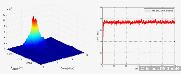
The winner of the European Satellite Navigation Competition (ESNC) 2014 is Airbus Defence & Space, which won over the jury of experts from around the world with its ground-breaking and cost-effective receiver for the Galileo Public Regulated Service (PRS).
The award winners were announced October 23 at an awards ceremony held at the Berlin headquarters of Deutsche Telekom. The awards recognize innovations in the commercial use of satellite navigation technology.
“Award winners Wolfgang Kogler and Jan Wendel from Airbus Defence & Space have taken a cutting-edge approach to designing a low-cost receiver that enables police departments, fire brigades, emergency medical services, and other public entities to make use of the Galileo PRS system,” The ESNC said. “Its core innovation involves the development of a special network architecture that combines the receiver with an assistance server. The concept accounts for all the required security aspects and significantly reduces costs and the complexity of user receivers, thus facilitating broader use of PRS in the realm of public security.”
In addition to the EUR 20,000 grand prize, the design took home Bavaria’s regional prize and the ESNC’s special PRS prize, which was awarded by Germany’s Federal Ministry of Transport and Digital Infrastructure (BMVI) and Federal Ministry for Economic Affairs and Energy (BMWi).
“This special prize reflects our effort to further examine possibilities for the use of PRS applications,” said Tobias Miethaner, Head of the BMVI’s Digital Society, in his opening address at the awards ceremony. “I am delighted to see that the ESNC is already providing an important impetus to the promotion and development of innovative applications of the future Galileo PRS in its first year.”
Over the past decade, the ESNC has brought forth numerous new applications in the field of satellite navigation. The 2014 edition was shaped in particular by the imminent launch of the first Galileo services, with more than 40% of the 434 submissions received from more than 40 countries seeking to employ Galileo/EGNOS in their own products and services.
“Thanks to our international network, we’re in an excellent position to take advantage of Galileo’s operational launch,” said Thorsten Rudolph, managing director of Anwendungszentrum GmbH Oberpfaffenhofen, which initiated and continues to organize the ESNC. “We believe that the ESNC’s function as a leading innovation framework in its field will grant it an equally important role in Europe’s new satellite navigation system.”
Along with the overall winner, 240 experts in the ESNC’s renowned network selected more than 30 other winners in the competition’s regional and special-prize challenges. Under the patronage of Germany’s Federal Minister of Transport, prizes worth a total of EUR 1 million were presented at the awards ceremony. The winners illustrated the fundamental importance of robust, reliable, and secure time and positioning signals for Europe’s digital society through innovations in areas such as transport, health, and the environment.
2014 Special Prize Winners
In addition to selecting its overall winner, the 11th European Satellite Navigation Competition (ESNC) has awarded prizes in six different special categories and to 25 regional winners.
GSA: The most promising application idea for European GNSS
The Galileo for ARA module will use a key feature of Galileo – its E5 broadband signal – to create new possibilities in the development of smartphone applications that require high accuracy. The team thus plans to integrate E5 Galileo receiver modules for enhanced accuracy and develop an antenna interface module to provide better performance. This will offer improved positioning precision with centimetre-level accuracy and a multipath-resistant solution designed for pedestrians and urban environments.
ESA Innovation Prize & Flanders/Belgium — Overall Ranking: 3rd Place
stickNtrack is a disruptive innovation that opens up an abundance of new business opportunities in tracking trailers, containers, machinery, tools, bikes, and more. It functions for up to 10 years without the hassle of charging batteries, managing SIM cards, or any intrusive installations while consuming up to 40 times less power. StickNtrack also lowers life-cycle costs by 50% compared to current compact GPRS/GPS products.
This artificial ground-based solution will significantly boost the coverage of satellite-based augmentation systems (SBAS, such as EGNOS) to ensure safe landings on all airport runways. SBAS assistance can be limited due to a lack of signal coverage in the far north, in the mountains, or in highly urbanised areas. By receiving and retransmitting GPS corrections, the proposed system will enable the use of systems like EGNOS in such difficult environments. Thanks to its competitive cost and reliability, this system will be a strong alternative to conventional instrument landing systems (ILS).
Hail Navigator is a novel system designed to reduce damage caused by hail. The formation of hail can be suppressed by injecting silver iodide into clouds. Hail Navigator combines navigation with a precipitation reporting system that can guide pilots to the optimal locations for their hail suppression missions. The system is complemented by weather observations (including precise times and locations) reported by the local population via a smartphone app as a means of validating weather prediction models. These models constitute an important factor in deciding whether a hail suppression flight is necessary.
trakkies has built the world’s first REAL platform for the Internet of Things (IOT). It enables users to keep better track of belongings, events, tasks, appointments, and more. The start-up has developed IOT nodes with ambient intelligence, a smartphone app, and a back-end cloud system for providing helpful, intuitive services and interacting with people, places, and things. Furthermore, trakkies has designed a novel small-data mechanism that identifies individual people, places, and objects and uses EGNOS signals to create smart location references.