WASHINGTON – On Friday, Oct. 16, the GPS Innovation Alliance (GPSIA) submitted two filings regarding federal spectrum policy. Comments were filed in response to a public notice in the U.S. Department of Transportation’s (DOT) GPS Adjacent Band Compatibility assessment, and testimony was submitted for the record to a U.S. House Energy and Commerce subcommittee in response to its recent hearing, “Improving Federal Spectrum Systems.” Both filings stressed that the “1 dB standard” is the appropriate criterion for testing the compatibility of terrestrial broadband and GPS operations.
The GPS Innovation Alliance has consistently supported the more complete use of underused spectrum where technically feasible. In both filings, GPSIA expressed support for each government entity’s ongoing efforts and stressed the importance of protecting GPS, one of the country’s most important and ubiquitous national utilities.
Regarding the DOT effort, GPSIA offered suggestions relating to certain aspects of the proceeding and voiced support for the “1 dB standard” in testing — which would determine Adjacent Band Masks based on a measurement of received interference test signal power levels that cause a 1 decibel (dB) degradation in the receiver’s Carrier-to-Noise Density Ratio. As outlined in GPSIA’s comments, the organization’s support for the 1 dB standard is based on its long and well-established history in international and domestic regulatory proceedings and difficulties associated with other standards.
GPSIA wrote: “While DOT has proposed recording other performance metrics, such as loss of signal lock or degradation of pseudo-range or position accuracy, GPSIA believes these are inappropriate metrics for interference assessment since their inherent basis is an interference level that seriously degrades the RNSS spectrum environment and causes significant disruption to GPS receivers.”
Degradation of accuracy or otherwise attempting to determine effects on the “user experience” are not practicable interference metrics, and DOT should rely upon the 1 dB protection criteria in derivation of the Adjacent Band Masks. GPS receivers are used in a tremendous range of end user applications beyond simple navigation. It is unclear how it would be possible to determine whether there has been “material degradation” in the functioning of this wide range of GPS applications, much less what constitutes degradation that is “material.”
GPSIA also submitted testimony for the record in response to an Oct. 7 hearing by the House Subcommittee on Commerce and Technology, where the potential for repurposing spectrum currently reserved for use by satellite applications for terrestrial broadband was discussed, but without addressing the difficult technical challenges associated with repurposing satellite spectrum.
A key theme raised in the GPSIA testimony is support for allocating similar uses for spectrum in close proximity to each other. Doing so is an approach that is preferable to adopting receiver standards. GPSIA also explained the unique technical differences between communications and navigation spectrum use.
“A straightforward approach is to minimize the number of dissimilar spectrum applications in close spectral proximity to each other,” GPSIA said. “Put another way, similar spectrum uses should be grouped together to the greatest extent possible to minimize the number of band edges or ‘border areas’ where dissimilar uses in close proximity create serious interference challenges. This approach minimizes the need for the FCC to engage in extensive rule making to balance the interests of dissimilar spectrum uses in every spectrum ‘border’ area.”
GPSIA then noted that “attempts to attribute Global Navigation Satellite System (GNSS) interference issues mainly to poor receiver design are misguided. The FCC has long understood that receivers designed to receive one set of frequencies can be ‘overloaded’ by transmissions in adjacent frequencies.”
In fact, overload interference is not unique to GPS, whose receivers are typically designed to withstand adjacent band transmissions hundreds of millions of times stronger than GPS signals and compare favorably to other common types of mass market receivers.
GPSIA again voiced support for the 1 dB standard for testing, explaining that communications systems operate above the noise floor spectrum while GPS signals are below the thermal noise floor when they are received.
“Because GNSS operates below the noise floor, the most appropriate means by which to assess the potential of new adjacent band systems is whether the new service causes a 1 dB degradation in a receiver’s Carrier-to-Noise Ratio.” Other interference metrics, the GPSIA explained, “are based on interference levels that seriously degrade the GNSS spectrum environment and will cause devastating disruption to GPS receivers.”
“Use of a 1 dB standard is vastly superior to an approach that attempts to assess whether there is ‘actual’ harm to an incumbent service, which wrongly assumes that you can accurately predict the impact of a new service across a heterogeneous series of devices in adjacent spectrum. Defining harmful interference by reference to a level of degradation to a particular key performance indicator among a limited universe of devices and applications fails to account for and support future innovation, including known and currently unknown applications which could take advantage of ever increasing accuracy of the position, navigation and timing functions of GPS. Use of a defined change in the noise floor (1 dB) provides a readily identifiable and predictable metric that all interested parties can take into account now and in the future.”
GPSIA’s testimony concluded by urging policy makers to engage in “rational, long term spectrum planning,” noting that a focus solely on regulation of receiver characteristics is likely to have limited usefulness and may be inefficient and harmful to continued innovation in affected spectrum uses.
The GPS Innovation Alliance recognizes the ever increasing importance of Global Positioning System (GPS) and other Global Navigation Satellite System (GNSS) technologies to the global economy and infrastructure and is firmly committed to furthering GPS innovation, creativity and entrepreneurship. The GPS Innovation Alliance seeks to protect, promote and enhance the use of GPS. For more information, visit www.gpsalliance.org.
Here it comes right at ya, down the cable into your living room, over the radio waves into the coffee shop or airport and your car: the Internet of Everything (IOE).
The term connotes adding connectivity and intelligence to just about every tech device in use at home, office, or out on the street, to enable special functions, reporting, and command/control. From kitchen appliances to cars, it’s anything with “smart” in front of its name, tied to the Internet and interconnected to tech-ecosystems of software, services, data warehouses, and yet other smart devices, starting but certainly not ending with your phone, watch, tablet or PC.
Most semiconductor companies have fielded new processors aimed at IOE. Broadcom’s new chip, reported in this issue, folds GNSS into the digital cake mix. Market research predicts 220 billion connected devices in use by 2020, and market size in the trillions. Trillions.
The bandwidth to run this new ecosystem is truly staggering. Available spectrum just won’t do it, not in the way we’re using it. Far more precise timing of data packets shot through the cloud will be necessary.
Thus our cover story. GNSS — well, GPS so far — is tightly woven into the fabric of financial and security infrastructure because it furnishes micro- and nanosecond synchronization. Nanos ain’t where it’s at in another eyeblink more. Picoseconds will be the new standard.
GNSS as currently constituted cannot do picoseconds. Another technology or technologies will be required.
This is true on nearly every front, every sector in which GNSS has enabled so much that previously was inconceivable or just plain unconceived. We’re headed further in all those directions, and GNSS can’t get us there alone. Aided and abetted by other positioning, navigation, and timing (PNT) technologies, it can.
The magazine has long covered other PNT technologies, but starting in November you’ll see a whole lot more of this. Every PNT technology, in every issue, in some way. That’s my IOU. Because, after all, it’s a World of Everything.
Pink for a Cure
Our cover logo this month signals that North Coast Media (NCM) is doing something to helpmake a difference. Because October is our company’s largest revenue month each year, our leadership team hascommitted to donate a portion of the company’s October revenues to cancer research. In 2014, NCM donated $8,000to this very worthy cause. The disease has touched the lives of nearly everyone on the NCM team; we’re very excited to be able todo something that matters.
LAS VEGAS — About 30,000 attendees sweltered in Las Vegas for CTIA’s Super Mobility show this past week. Attendance was flat from last year, but the exhibit floor and meeting rooms bustled. The energy of the show focused on M2M and Internet of Things (IoT). In past years, the connected vehicle was a highlight, but not so this year. Wearable technology was scant. Those looking for the big product introductions of the past were disappointed. However, CTIA’s keynote speakers added focus and vision into the show, reminding us of the drive and vigor that built the industry.
In the past, the network operators (we once called them carriers) and device manufacturers owned the CTIA show, where they made their biggest product reveals. This year, AT&T had a flurry of announcements, including a partnership with car manufacturer Jaguar Land Rover North America. AT&T will supply connectivity to the cars for features such as Wi-Fi hotspots, connected navigation and a suite of apps. Customers will be able to share wireless data between phones, tablets and vehicles on its Mobile Share Value plan for an additional 10 dollars per month access fee. AT&T previously signed agreements with Audi, BMW, GM, Ford, Tesla, Nissan, Volvo and Subaru.
AT&T and Telogis announced a collaboration to offer solutions for companies with mobile workforces, a combination of AT&T’s network and Telogis’ telematics, compliance and navigation fleet solutions. AT&T was showing off ZTE Mobley, AT&T’s first plug-in vehicle Wi-Fi hotspot, which has just appeared in stores. Smaller announcements from AT&T included the formation of a dedicated smart city organization and a personal security app that provides live, OnStar-type professional monitoring (video and audio).
Verizon unveiled Go90, a streaming-video, social media service that works across carriers. Go90 is a free, ad-based service accessed only on a mobile phone and focused on short clips, viral videos and a social element, with crowdsourced recommendations and the ability to join groups. Go90 is targeted at Millennials, people younger than 30 years old. Although this seems like a minor announcement, obtaining the loyalty of Millennials and Generation Z (those still in their teens) is critical. With two-thirds of Millennials considering smartphones as their most important device for video, the strategy behind Go90 makes sense.
New Sprint CEO Marcelo Claure is never boring and used his time at the podium to continue trash- talking the competition. With cocky confidence, he pronounced that under his leadership, Sprint will enjoy “one of the biggest turnarounds in telecom history.” In July, Claure used Twitter to declare T-Mobile’s aggressive “uncarrrier” promotion to be “bullshit and a fake show.” He continued his rant at CTIA. “We spent the first year cutting AT&T or Verizon’s bills in half, which was fun. We’ve moved on today to offering all the DirecTV customers the choice to not be stuck with AT&T.”
One of the most pressing industry issues is spectrum. With wireless data forecast to grow ten-fold by the end of 2020, the industry is concerned that the 2016 spectrum auction will not be sufficient. Keynotes appealed for more spectrum to enable the U.S. to lead in 5G, just as it led in 4G. U.S. company-run operating systems are currently on nine out of ten smartphones, worldwide. FCC Chief Tom Wheeler was at CTIA to give assurances that the spectrum auction slated for March 2016 will be successful and occur as scheduled. He countered CTIA’s CEO Meredith Baker’s assertion that the FCC has no added plans beyond this auction for freeing up spectrum.
Freetel mobile products of Japan was one of several international companies participating in CTIA this year.
Location Players, M2M, IoT
TeleCommunication Systems (TCS), a stalwart of location-based services, beefed up its indoor location capabilities with the purchase of Loctronix. The platform, Sensorvision, aggregates and integrates location-positioning technologies, like Bluetooth, beacons and Wi-Fi, as well as content, such as mapping. Sensorvision is currently in beta testing and is aimed at wireless operators. With more stringent rules for 911, including indoor location requirements, TCS is positioned for both public safety and commercial needs. What’s next? In five years, Michael Mathews of TCS predicts, “We’ll be talking about the huge amount of information available from the road and the great impact on apps, including vehicles that are informing other cars of their actions, such as when they initiate traction control or start windshield wipers.”
u-blox, the maker of wireless and positioning modules and chips, announced a portfolio of new LTE low data rate cellular modules for IoT and M2M applications in the industrial and automotive markets. The portfolio consists of multi mode, multi carrier and of LTE only modules specific for large North American carriers. u-blox expects LTE Cat. 1 technology to become the future norm for M2M applications. And when asked about long-term success, Sven Etzold of u-box says, “The challenge for our industry is picking the right partners and being part of successful consortia. We need to partner with the right network operators and play with sensors’ companies.”
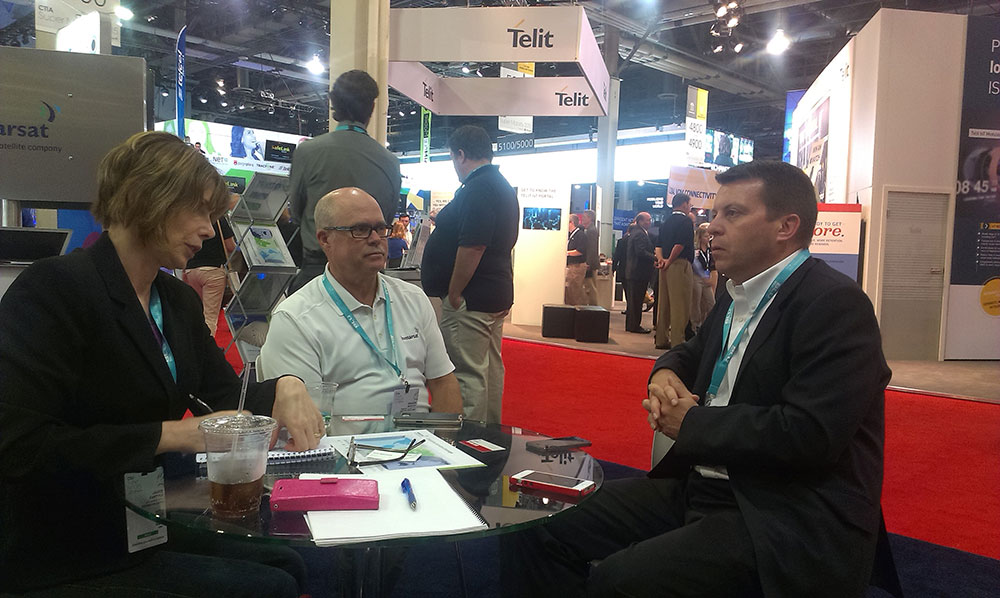
Janice visits with Chuck Moseley (center) and Don Wigglesworth (right) of Inmarsat.
Inmarsat unveiled its new machine-to-machine (M2M) and its IoT strategy, the “Internet of Everywhere.” The company is increasing use of VARs and OEMs to enable solutions that will provide more visibility and control of mobile assets throughout the world. “We are empowering existing and prospective VAR partners to offer unparalleled worldwide connectivity to their M2M and IoT customers through a single network and a single SIM,” said David Wigglesworth of Inmarsat. The company’s dedicated M2M services are IsatData Pro, a low-data-rate messaging service, and BGAN M2M, a two-way IP data service for monitoring and control of assets that require higher bandwidth capabilities.
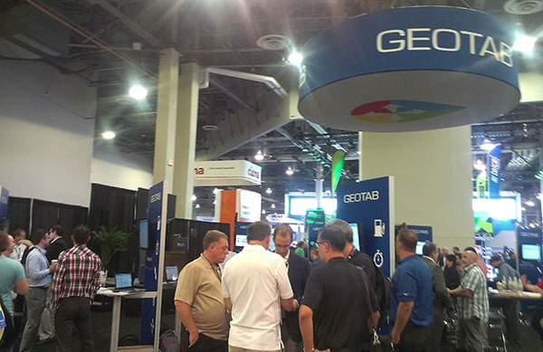
Geotab, with one of the exhibit floor’s most crowded booths, showcased the development platform of a small form-factor GPS tracking device. The Geotab GO7 device plugs directly into a vehicle’s OBDII port. Developers create applications that are available on the Geotab Marketplace. The booth was crammed with developers who offer M2M and IoT solutions.
Geotab’s booth was crowded with developers interested in the Geotab Marketplace for M2M and IoT solutions.
Microsoft’s Start-Up Alley contained interesting ventures from the Microsoft Accelerator. One young company, Parknav, offered an app for finding parking spaces based on predictive modeling, and not sensors. Users are guided to street blocks with the highest probability of available parking spaces. The app uses a number of sources, including number of parking spaces, traffic flow and undisclosed data. Parknav enables searches for free, paid and permit parking in 30 cities in Germany and a few cities in the U.S.
On a charitable note, Jimmy Whales of Wikipedia fame was at CTIA to promote his phone business, a Sprint-based MVNO cellular service. Like Wikipedia, The People’s Operator (TPO) is not a profit driven enterprise. Ten percent of a subscriber’s monthly bill goes to a charity of her choosing, and 25 percent of the company’s profits are donated to non-profits. In talking about Wikipedia, Whales cited China’s current ban of the website. Wikipedia has recently made changes to its website that make it impossible for censors to ban specific Wikipedia pages, although the entire site can be blocked, as it currently is in China.
I have parting advice for the organizers of CTIA. This year’s show was disrupted by competing events that included the iPhone 6 announcement in Cupertino. Shame on Apple, who is a member of the CTIA board. Also, CTIA had organized a virtual co-conferencing with Internationale Funkausstellung Berlin (IFA), one of the largest trade shows for consumer electronics and home appliances. The IFA event was held in Berlin the prior week and stole attention from CTIA. It isn’t all about location. Timing matters.
Wheeler Also Discusses Spectrum Incentive Auction on CTIA Stage
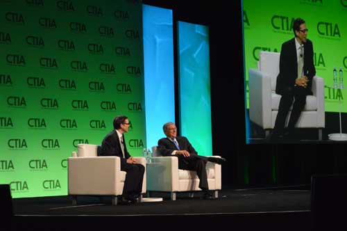
LA Times writer Jon Healey interviews the FCC’s Tom Wheeler in a fireside chat at CTIA.
As one of Super Mobility 2015’s first speakers, Federal Communications Commission (FCC) Chairman Tom Wheeler reaffirmed his support for the net neutrality rules that CTIA-The Wireless Association, the event’s host, has been fighting in court.
Wheeler harkened back to his speech to this same audience last year where he received a “less than thunderous response” to his suggestion that broadband should be classified as a public utility. Previously, the FCC had treated broadband as an information service separate from the telephone network.
“If you have that kind of a role in delivery of Internet, then you ought to be governed under a similar set of rules that apply to everyone and not have a wireless exception,” Wheeler said.
Net neutrality rules enacted by the FCC early this year prohibit mobile broadband providers from throttling Internet content and utilizing paid prioritization. CTIA filed a brief with the U.S. Court of Appeals in Washington, D.C., this summer in conjunction with other industry associations, opposing the regulation saying it could have “devastating impact on Americans and the U.S. economy.”
“Imposing Title II on wireless would be a gross overreaction that would interrupt the world’s best wireless industry and interfere with the significant innovations and competition consumers enjoy today.”
Wheeler disagreed on stage during a fireside chat with Los Angeles Times editorial writer Jon Healey. He pointed out the “tens of billions of dollars” the wireless industry has invested.
“I’m very bullish on the continued growth of this industry and the continued protection of consumers and how they use the net,” he said.
Wheeler said he was also “supremely confident” that the incentive auction for 600MHz of broadcast TV spectrum, scheduled to start March 29, 2016, would go off without a hitch and that broadcasters would be there and would agree to sell their spectrum rights. Don’t believe him? Take it from James Murdoch, new CEO of News Corp., he said.
“I told him I was going to be talking to you today, and I said, ‘Can I tell him you’re going to show up?’ and he said, ‘Yup,’” Wheeler explained to Healey. “We had a fascinating discussion about how the broadcast business has changed. The most interesting part of my conversation with…Murdoch was talking about innovation and need to be continually innovative. The broadcast auction offers incredible opportunities for broadcasters to get a pot of money to innovate with without losing the business model they’ve been successful with.”
In May 2011, Dinesh Manandhar and Hideyuki Torimoto of GNSS Technologies, Inc., Japan, penned a very interesting article in GPS World titled – Opening Up Indoors: Japan’s Indoor Messaging System, IMES. The opening paragraph of their lengthy article seemingly describes the Holy Grail for the indoor positioning lobby:
“An indoor messaging system (IMES) has been developed to meet the challenges of indoor and deep indoor positioning, as a system that can be implemented in any device that has a GPS/GNSS receiver without hardware modification. IMES can provide reliable 3D position data with a single transmitter device without performing range calculation[s].”
They go on to describe the IMES concept thusly:
“The main concept of IMES is to transmit position and floor ID of the transmitter with the same RF signal as GPS. IMES transmits latitude, longitude, height, and floor ID by replacing the ephemeris and clock data in the navigation message of GPS. A single unit of IMES is enough to get the position data, since the position itself is directly transmitted.”
Now, you don’t have to be a rocket scientist to start thinking about interference and spoofing issues or risks, especially when you read that the navigation message ephemeris and clock data are being replaced by data broadcast by IMES. To be fair, the authors address these issues briefly:
“Since IMES shares the same frequency as [the] GPS L1 band (1575.42 MHz), there is an interference level that IMES may have on GPS signals. This interference has been studied in detail by conducting experiments and simulations. Based on these studies and analysis, various methods have been considered to avoid harmful interference to GPS signal. To avoid such interference, IMES center frequency is shifted by +/– 8.2 KHz from GPS L1 band. This will have the least impact on the GPS L1 band signal. For example, if the IMES signal is –110 dBm (very strong) and the GPS signal is –142 dBm (very weak), the loss of GPS signal (C/N0) due to IMES is less than 2 db. If the IMES signal is –120 dBm and the GPS signal is –142 dBm, there is no loss of GPS signal (C/N0). Based on this analysis, the IMES transmitter power must be controlled such that the maximum power to the receiver does not exceed –110 dBm at a distance of 3 meters from the transmitter. [There are] guideline[s] specified in the QZSS IS document for setting the transmitter effective isotropic radiated power (EIRP) based on location.”
Let’s put these concerns in perspective. I thoroughly enjoyed the article and firmly believe that we desperately need to solve the indoor positioning and navigation problems, especially for our warfighters and first responders. While many of today’s excellent commercial receivers work well indoors near windows and doors, they are absolutely abysmal underground and deep inside large buildings with lots of metal, or in the middle of dense urban canyons such as Tokyo, Japan. Without a doubt, there is a dire need for a system like IMES — or maybe exactly like IMES — but there must be some caveats and stipulations as to how the IMES system is implemented.
Not Alone
Fortunately, I am far from being a lone wolf in voicing my concerns and my position, for once again the conspiracy theorists as well as renowned scientist and policy makers are concerned about IMES and the operating systems they supposedly desire to replace or augment. Chief among them is the Father of GPS, Dr. Bradford Parkinson, who has frequently described improperly operated in-band pseudolites as “…just another name for a legal jammer or spoofer.” Having known Brad for almost 40 years, I am convinced few GPS experts in the world today have as much experience with pseudolites as Dr. Parkinson. Consequently, the very reason that an indoor navigation system such as IMES is needed may well be a portent for why it may well fail, unless it is implemented properly.
It would be easy but extremely tedious to write about the numerous issues facing IMES in a complicated and technical manner. Certainly previous articles have become bogged down in minutia, and I want to avoid that. It is actually very simple. The issues are fairly straightforward and should be faced head on and not hidden in the midst of tech-speak lingo, legal jargon, policy minutia or politics. So lets dive straight in, shall w,e and make sure these issues see the light of day?
Interference
There can be no doubt that IMES has the potential to significantly interfere with GPS and QZSS signals. The authors of the IMES article are quite clear concerning the potential for interference, and in their own way attempt to mitigate it with signal power restrictions. Their example of a small three- to four-story building with IMES transmitters may indeed be adequate for signal power mitigations, but what happens in Tokyo where tall buildings — skyscrapers if you will — abound? When the Tokyo Skytree skyscraper opened to the public in 2012, it was then listed as the world’s tallest tower and Japan’s biggest new landmark. At over 2,080 feet tall, this is definitely the type of building where one would need an IMES system. With an average of 20 IMES transmitters per floor and weighing in with over 200 floors, we can quickly see that there would be over 4,000 IMES transmitters in this one building alone, all broadcasting simultaneously on or near the center frequency for GPS. Absent stringent regulations and infinite care (the IMES article authors propose that the pseudolite network operator will have the responsibility to continuously monitor each pseudolite and the pseudolite network to prevent interference), and perhaps even with those caveats in place, the GPS L-band noise floor would be such that GPS signals would be incapable of being received.
Now, put 20 such buildings in a ten-block area and the noise floor would be almost incalculable and certainly not predictable. Dr. Parkinson’s fears are realized; your legalized IMES system becomes a distributed network of jammers and/or spoofers. However, technically IMES is currently far from being a legal jammer or spoofer as currently IMES transmitters are not legal to operate in the GPS band at 1559-1610 MHz under the International Telecommunications Union (ITU) Treaty per the International Table of Frequency Allocations of the ITU Radio Regulations. The ITU further states that IMES currently operates on an interfering basis with the co-primary allocations (ARNS/RNSS) in this band, and therefore are in violation of the ITU Treaty. However, Japan’s frequency regulatory agency can develop and implement regulations that allow IMES operations. When this occurs, if not operated within stringent guidelines, IMES could then be considered a legalized jammer or spoofer.
Even the Joint Research Centre of the European Commission, the JRC, states in its Executive Summary on pseudolites that in-band pseudolites pose a significant jamming risk to GNSS receivers. Specifically they state:
Pseudolites or pseudo-satellites are an emerging technology with the potential of enabling satellite navigation indoors. This technology found several applications that are not limited to indoor navigation. Precise landing, emergency services in difficult environments and precise positioning and machine control are few examples where pseudolite technology can be employed.
Despite the great potential of this technology, severe interference problems with existing GNSS services can arise. The problem can be particularly severe when considering non-participating receivers — legacy devices not designed for pseudolite signals. The design of pseudolite signals is thus a complex problem that has to account for market requirements (modifications of existing receivers for enabling the use of pseudolite signals, measurement accuracy, target application), regulatory aspects (frequency bands to be allocated for pseudolite services) and interference problems.
JRC investigates the main aspects to be considered for the design of a pseudolite signal standard minimizing the interference problem without compromising the location capabilities of the system. The focus is on the signal characteristics and topics relevant for the signal design.
Pseudolite or Communications System
The second technical portion of the interference issue revolves around how exactly you define IMES, for when you are dealing with radio regulation agencies semantics matter. Think back to the first paragraph of this article where the IMES authors defined IMES as a messaging system. That certainly sounds like a communications system to me, and others agree. Consequently, the question has been raised and rightfully so: Is IMES a navigation and positioning system, a pseudolite or a communications system? Honestly, to me it sounds like a bit of all three, but if you define it as a communications system, then Japan is seeking to authorize the integration of a communications system with known significant interference issues with GPS signals right in the middle — indeed, potentially on the center frequency of the protected navigation band using terrestrial PRN codes assigned by the U.S. government. If IMES is deemed an indoor pseudolite, then the interference issues are still there. But it is defined as a bonafide PNT system using authorized terrestrial PRN codes. Talk about a bucket of worms!
The issues here are numerous, and they need to be fully addressed to ensure that all those who are potentially affected clearly understand what is being proposed and the risk for the public at large, including who owns responsibility if something goes wrong. I could go on for several pages on this issue alone, but suffice it to say, we do not want to authorize a communications system that is a known and acknowledged GPS interferer right in the middle of the band — or anywhere in the band for that matter. Remember all the issues GPS had in the past several years with a communications system in adjacent bands. So, do we really want a known communications system — or communications system masquerading as a pseudolite, for that matter — with known GPS signal interference issues in the restricted GPS frequency spectrum? The blaringly obvious answer is absolutely not! Yet this is exactly what the IMES authors are proposing not only for Japan, but eventually, if they receive authorization, for other countries around the globe as well. Japan has twice petitioned the U.S. government to make the assigned IMES terrestrial PRN code allocations global in nature. Fortunately, to date those request have been denied.
Dichotomy
Certainly, other countries and companies have noticed this apparent frequency authorization dichotomy and are following suit. For instance the Conference of European Postal and Telecommunications agencies, or CEPT, which is Europe’s regional representative to the World Radiocommunication Conference (WRC), has proposed adding several troubling IMES-related agenda items for the quadrennial WRCs coming up in 2015 and 2019. Even more importantly, these critical issues could be aired in the next three weeks, as the agenda for the 2015 WRC will be largely set at a plenipotentiary conference happening October 20 through November 8 in Busan, South Korea.
There are what I consider to be dangerous proposals under consideration by the ITU (International Telecommunication Union), which should concern GNSS users worldwide. The ITU is the United Nations’ specialized agency for information and communication technologies — ICTs. This is the ITU, where every member state (currently 193) gets one vote, whether they fully understand the technical issues or not and regardless of whether they are a space-faring nation or have a dog in the fight, so to speak. This means that the vote of tiny Saint Lucia counts the same as the United States or Canada or Australia. The ITU charter is to “…allocate global radio spectrum and satellite orbits, develop the technical standards that ensure networks and technologies seamlessly interconnect, and strive to improve access to ICTs to underserved communities worldwide.” Fortunately, the ITU regulations, unlike the CEPT or IMES proposals, wisely require new transmitters proposing to operate in the radio navigation spectrum to operate without causing interference to primary users. Meanwhile, there are member states, countries and companies that want to capitalize on this seeming dichotomy within the global safety-of-life, historically protected, radio bands. Those nefarious efforts, for the future of GPS and GNSS worldwide, need to be stopped in their tracks.
Spectrum is a limited and valuable resource, to say the least, and here fortunately the ITU regulations have it right and do not risk human life, by intruding and potentially interfering with the frequencies used globally by airliners to control, route and land aircraft. I am convinced there are solutions available to us through cooperative efforts with the ITU and other national organizations that will produce pseudolites without causing interference in the protected safety-of-life frequency bands.
When Is a PRN Code Not a PRN Code?
Some of you who are a bit more savvy or have been following this fiasco for some time may now be thinking, what’s the problem, the IMES authors are merely using and proposing further use of U.S. government-authorized terrestrial PRN codes for IMES. This indeed touches on the third thorny issue, which is not only technical but political as well — the use of and authorization to use PRN codes for what is ostensibly a communications system, if you believe the authors of the IMES article, who go to great lengths to differentiate IMES from pseudolites. They continually make the argument that IMES is not a pseudolite, but as we shall soon see, when the U.S. government authorized these specific PRN codes (173-182) for Japan, they were to be used solely for a low-power terrestrial pseudolite program, not an in-band communications system.
Technically, these specific PRN codes assigned to the Japanese for IMES expire in 2017. The authorization of these PRN codes come with numerous restrictions that legally make the codes useful only for the Japanese landmass. This is where the technical, political and operational issues come to a head. We are in for some tough sledding here. However, I will endeavor to make it as simple as possible.
History
In 2007, ten PRN codes were specifically assigned to the Japan Aerospace Exploration Agency or JAXA “for the Indoor Messaging System (IMES) terrestrial pseudolites of the Quasi-Zenith Satellite System (QZSS).” The Memorandum of Agreement from the GPS Wing at SMC (Space and Missile Systems Center) in Los Angeles at Los Angeles Air Force Base (LAAFB) clearly states that the codes are valid for ten years and expire on 19 November 2017, unless a renewal application is filed and approved. Hence, PRN codes 173-182 for IMES were assigned with several crucial caveats and restrictions by the U.S. government that are definitely pertinent to our discussion:
The codes are designated for low-power terrestrial regional applications limited to Japan only.
Although the GPS Wing conducts an initial check on PRN number requests with respect to potential interference issues, the issuance of a PRN number does not convey authority to radiate in the [GPS] band. In order to radiate in the GPS L1 band, the applicant [Japan] shall obtain a frequency assignment from the [Japanese] national authority.
The GPS Wing assumes no responsibility for ensuring systems using these spreading codes follow domestic radio frequency regulations or other applicable laws or regulations, or for ensuring that systems using GPS PRN codes do not cause radio frequency interference.
GPS PRN codes were developed for signals transmitted from satellites, and are not necessarily optimized for use by terrestrial transmitters.
The maximum effective isotropic power for each terrestrial transmitter will be less than -94 dBW.
The QZSS [organization] is responsible for the redistribution of these spreading codes throughout Japan and will limit their use to Japan only.
With all these restrictions, it is difficult to see how the IMES authors could legally use, distribute or promote authorization of IMES and the use of the PRN codes outside of Japan and at the power levels related in the GPS World IMES article. Regardless of the IMES author’s interpretation of the PRN code assignment, the GPS Wing 2007 Memorandum restrictions and caveats are clear, and it cannot be disputed that the codes expire in 2017 unless renewed by the USAF. The PRN codes are restricted to the landmass of Japan even if they are renewed, and if IMES wishes to broadcast anywhere in the GPS band, they need to have permission from their national frequency allocation authority (the Ministry of Internal Affairs and Communications, which is equivalent to the U.S. FCC –Federal Communications Commission) to do so.
The Way Ahead
This is the easy part from my perspective. See if you don’t agree. If the U.S. government is concerned about IMES and what Japan is planning to do with the assigned PRN codes for terrestrial use, the U.S. government through the USAF has the options to:
Rescind the PRN codes immediately.
Insure the Japanese adhere to the caveats and restrictions in the original Memorandum.
Simply refuse to renew or recertify the codes for future use and/or recommend for IMES frequencies that are outside the protected GPS band.
Update and clarify the footnote on the GPS Wing PRN Codes website pertaining to the Japanese IMES PRN Codes with all the restrictions listed in the GPS Wing Memorandum so other countries will realize this is not a global IMES PRN assignment.
Japan is a valuable ally and we need to work together cooperatively, but frankly, the plans laid out for IMES by the authors in the GPS World article must be troubling to those whose job it is protect the GPS spectrum and enforce mutual agreements with our allies. If we were just concerned about a Japanese IMES system, this whole discussion might be moot. However, other countries and commercial companies around the world are watching closely and laying the groundwork for similar IMES and pseudolite incursions into the GPS L-band spectrum — if the Japanese are allowed to proceed and the limited use of PRN codes for IMES is not clarified for all. No one, and I include the Japanese, wants to see this happen if it means interference with GPS, and QZSS for that matter.
Fortunately, where European countries are concerned, there are the ITU regulations. Specifically for GPS and pseudolites, the CEPT regulation has a license condition that requires the pseudolite network operator to submit to the European country regulator confirmation of the terrestrial PRN codes from the GNSS operator before operating pseudolites in the GPS band. So again, the U.S. government wields the hammer here.
Therefore, the U.S. government must act immediately and decisively to put an end to the threats against the protected GPS spectrum caused by the proposed in-band IMES system. At the same time, the Japanese government has an obligation and responsibility to adhere to the letter of the law where the original GPS Wing 2007 IMES Memorandum is concerned.
Finally, the U.S. government must urgently engage cooperatively with the European Union administration and Japan to prevent the authorization and proliferation of interfering devices in the GNSS frequency bands, and to work together to ensure the positive benefits to GNSS from commercializing pseudolite uses outside the GNSS radio frequency bands. GNSS manufacturers worldwide are successfully marketing commercial pseudolites that do not cause interference. In my opinion, this is the way to go both in terms of regulations and governance.
Until next time, happy navigating, and remember GPS is brought to you free of charge by the United States Air Force.
Crowds streamed into the Sands Expo and Convention Center, Las Vegas, to the sounds of ’80s music icon Thomas Dolby and a string quartet covering the ’90s hit “Bittersweet Symphony,” but the buzz wasn’t about the morning keynote speech that would kick off CTIA Super Mobility Week. Instead, the impending Apple Live Event had taken over as a countdown clock ticked on the big screen.
The Apple circus — though alluded to in introductory remarks by CTIA Chairman Dan Mead, CEO of Verizon Wireless, and CTIA President Meredith Atwell Baker — would have to wait. First on the agenda: Several topics affecting the industry, with an emphasis on spectrum allocation.
Atwell Baker set up the three-day show, the first combining the CTIA conference with MobileCON. She cited dozens of figures about the incredible growth of the industry before focusing in on the need for a successful spectrum incentive auction with projected 886% mobile data usage growth by 2019.
“The U.S. had the third-lowest amount of spectrum dedicated to LTE,” she said. “How do we close the gap? The AWS-3 and 600MHz auction are a great start. We hear the wireless carriers may sit out of these auctions. Really? Given our track record, I’m incredulous wireless carriers wouldn’t bring billions of dollars to these auctions.”
The Federal Communications Commission (FCC) has been pushing for the spectrum incentive auctions to reallocate spectrum from television broadcasters to wireless providers for ever-increasing mobile usage.
In introducing Tom Wheeler, chairman of the FCC, Atwell Baker lauded his determination to bring the auctions to fruition.
Wheeler jumped right into his list of the Top 3 issues facing the business for the standing-room only crowd: the incentive auction, net neutrality and competition in the wireless industry.
Wheeler balanced his concerns with equal doses of praise, lauding CTIA for a “very thoughtful” paper arguing that mobile broadband should not be subject to the same rules as fixed broadband while alternately questioning why some consumers have been led to believe they have unlimited data usage or why others are targets for throttled usage.
“I’m hard-pressed to understand how either practice, much less the two together, could be a reasonable way to manage a network,” he said.
He also touched on the need to keep competition alive in the business and avoid the “walled gardens” of the past that created barriers to entry in the market.
“Where competition exists the commission must protect it. This industry has always told policymakers, ‘We’re different, we’re competitive, but in the last couple of years the FCC and Department of Justice had to be poised to protect that dynamic.”
Wheeler pointed out the wireless industry’s $260 billion 10-year infrastructure investment as “living proof that profit and progress can go hand in hand” before concluding on the topic of a shared front: spectrum allocation.
“Our greatest public asset is that which we cannot see: Spectrum. Your government has heard your cry for more spectrum. The Congress responded with a creative and courageous solution,” he said, “an incredibly complex, never-before attempted undertaking.”
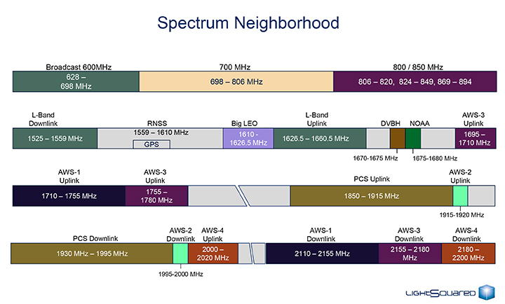
The U.S. Federal Communications Commission convened a June 20 workshop on “GPS Protection and Receiver Performance” whose bite turned out to be far less than its bark had led some in the GPS industry to fear. The hastily assembled workshop — three weeks notice was given — appeared at first notice to derive from the call for “GPS receiver performance standards” that was one of the outcomes of the LightSquared controversy of 2012. The FCC chief emphatically noted, however, before anyone else could say anything, that the meeting was “not about FCC-mandated receiver standards.” A nearly audible sigh came from the collected dignitaries.
Perhaps the slotting of “GPS Protection” into first position within the workshop’s title might have given some clue. The meeting did turn out to be a less-than-alarming gathering of stakeholders, and in fact a reiteration of the need to emphasize and safeguard critical infrastructure and public safety — two key uses of GPS.
Two weeks prior to the workshop, Brad Parkinson declared to the National Space-Based Positioning, Navigation, and Timing (PNT) Advisory Board that “A number of manufacturers are quite panicked over this because of the possibility of some superposition of, in essence, how you design a receiver for GPS. This could vastly affect the whole substance of what we are if carried to the point that someone dictates how you design a receiver. I think that’s kind of dangerous.”
But the meeting, in the end, took a positive, protective, and conciliatory tone, even as the FCC continues beating the drum for more frequencies for mobile broadband, citing the need “get more out of the radio spectrum.”
“Today is about federal and non-federal leaders coming together to discuss successful industry-driven collaborations and GPS receiver performance,” said FCC Chairman Tom Wheeler in his opening remarks. “These are not abstract issues. But let me also be specific about what today is not. It is not about FCC-mandated receiver standards. Rather it is about the best way to protect GPS operations in the context of evolving technology and adjacent spectrum activities.”
The specter of adjacent spectrum use hovered intermittently throughout the day, appearing fully in the presentation by LightSquared and one from the President’s representative. Otherwise, scant mention was made of the oft-expressed 2012 sentiment that GPS receivers needed to be modified in the way they work, to stop their alleged “peeking” into adjacent spectrum.
Peekin’? We don’t need no steenkin’ peekin’!
After further introductory remarks from the FCC’s head of Public Safety and Homeland Security Bureau, the audience heard a technology market update from the U.S. Consumer Electronics Association (CEA). The report relied almost entirely upon the European GNSS Agency’s (GSA’s) 2013 GNSS Market Report for its global statistics, while displaying some domestic charts of its own. Among the conclusions: GPS/GNSS is an enabling technology for innovation and disruption; and the consumer market, defined as road and location-based services (LBS), represents the biggest opportunity. The CEA presentation is available here.
The morning’s first panel discussion focused on the importance of GPS for critical infrastructure and public safety users, with presentations by Qualcomm, Motorola, and AT&T in addition to various government agencies. Cormac Conroy, vice president at Qualcomm, emphasized the critical role of GPS in emergency calls from mobile phones (E-911) and what he called “enhanced location services”: vehicle and pedestrian navigation, location-based alerts and reminders, and location as context in mobile apps.
Other speakers, including representatives from Ericsson, T-Mobile, Spirent, Garmin, NovAtel, and John Deere, covered GPS’s role in timing and thus controlling the nation’s power grid, the financial markets, the telecommunication network including cable TV, and the national breadbasket, precision agriculture. Paul Galyean of Deere said that “Certainty on the spectrum environment is needed. It’s difficult to design for the future without it.” And further, if GPS receivers had to filter out cellular activity, this “might impact sensitivity, involve excessive size or cost, and might cause distortion of GPS measurements.” The Deere presentation is available here.
Chris Hegarty from the MITRE Corporation gave one of the day’s most compelling arguments for not overhauling GPS receiver methodology: the extremely long lead times for commercial passenger aircraft. “Until 2022 every new Boeing and Airbus is going to fly off with $250,000 worth of navigation equipment that has three $50,000 GPS receivers and antennas and everything else, and they are going to want to use that for 20 to 25 years. So, you have a timing issue. Even if we all decided today that we wanted to do that, some communities simply aren’t going to be able to get it into place until we’re all dead.”
White House Espouses Adjacent Spectrum
Tom Power, deputy chief technology officer for telecommunications, held up the banner for “efficient use of spectrum” and pronounced the Administration opposed to “listening in.” Ironic, given its other proclivities. He advocated against some technologies exerting undue elbow room on “nearby users who want to make a change.”
LightSquared, the company that mounted a powerful threat to GPS signals, declared bankruptcy on May 14, after losing a lengthy struggle in the court of the Federal Communications Commission (FCC) with the GPS industry, the U.S. military (behind the scenes), the Federal Aviation Administration, and many other GPS users. However, the vacuum into which Lightsquared sought to step — a dearth of spectrum for exploding mobile data use, up 123 percent last year — remains a gaping hole that will likely attract other entrants.
The Lightsquared bankruptcy move followed collapse of negotiations with lenders to the company, and will likely give CEO Philip Falcone several further months of control. It is not known whether his efforts will seek to salvage the business plan to provide wholesale broadband capacity to wireless carriers, who need more capacity to feed a ravenous market. In her May Wireless Pulse column, GPS World contributing editor Janice Partyka writes, “Carriers [at the CTIA industry show] sounded alarms about running out of spectrum to support ballooning mobile data consumption.”
As a result of the February FCC decision to revoke LightSquared’s conditional waiver to broadcast a powerful terrestrial signal immediately adjacent to a band reserved for satellite services, the company’s main asset, its spectrum license, lost most of its potential value, unless significantly repackaged and redirected, or traded for another spectrum band..
In late 2010, when the LightSquared threat first surfaced, Falcone maintained that LightSquared’s interference issues were not his to solve, because GPS users were encroaching on his spectrum. “People who are in adjacent bands have to understand that there is now a new driver in town driving on that highway,” he said. “And they can’t be weaving in and out of that highway.”
Falcone now has to deal with creditors who include Carl Icahn, the near-legendary corporate raider. Icahn and other investors have bought about $300 million of LightSquared debt. “Icahn is a take-control, alpha-male investor,” said Brad Balter, head of Balter Capital Management, as quoted in a May 3 Business Week story. “Falcone is both desperate and naive if he thinks of Icahn as anything other than an adversary who would wrest control of the spectrum if LightSquared went into bankruptcy.” What Icahn might venture if he gained control of LightSquared spectrum represents another unknown on the GPS horizon.
Spectrum Shortage. Meanwhile, writes GPS World editor Partyka, “Verizon Wireless and T-Mobile executives complained that the future of data use is at risk if more spectrum isn’t put to use. FCC Chairman Julius Genachowski defended the agency’s decision to block the AT&T T-Mobile deal with a rejoinder about spectrum shortage. ‘Some have argued that transactions — let’s be frank, one transaction — is somehow causing a shortage,’ said Genachowski. ‘But the overall amount of spectrum hasn’t changed.’ While this is true, spectrum is a concern. CTIA reports that U.S mobile data traffic surged 123 percent in 2011.”
In a statement regarding the company’s bankruptcy filing, Marc Montagner, interim co-chief operating officer and chief financial officer, stated “All LightSquared distribution partners and customers, including public safety, emergency response, government, and military users of LightSquared’s satellite-based communications services can continue to rely on LightSquared to provide them with mission critical communications services. The filing was necessary to preserve the value of our business and to ensure continued operations. The voluntary Chapter 11 filing is intended to give LightSquared sufficient breathing room to continue working through the regulatory process that will allow us to build our 4G wireless network.”