The West Virginia Department of Transportation (WVDOT) turned to UAVs to save time and money. Incorporating drones has saved WVDOT more than $340,000 in a single month.
In 2017, WVDOT began formally looking into launching a drone program. WVDOT concluded that drones could be ideal for stockpile surveys — using them had the potential to speed up the process, reduce risk, and increase accuracy.
Jesse Bennett, statewide survey unit leader at WVDOT, flew several test missions to validate the use case. He quickly realized drones had huge potential to transform this time-consuming and risky task.
The agency began with a team of nine Federal Aviation Administration-certified drone pilots and 12 drones. WVDOT also began using Skyward’s Drone Management Platform to manage their flights, pilots and equipment. Skyward offered a single, digital platform to coordinate complex missions and obtain airspace permissions.
“I saw the need for something like Skyward from the very beginning, when I was the first and only pilot,” Bennett said. “I was manually making entries in flight logs and maintenance logs, and I was using about seven or eight different apps and websites just to plan and fly a mission.”
Using Skyward as a single place to keep track of every aspect of the drone program enabled Bennett to quickly resolve an investigation after someone mistakenly assumed he didn’t have authorization to fly in an area and reported him to the FAA.The software helped him demonstrate that crews were obeying FAA regulations and WVDOT’s own rules.
Starting in spring 2019, WVDOT began deploying drone crews for stockpile inspections at scale. WVDOT has 177 sites across the state that contain stockpiled materials. Each year, the stockpiles must be physically surveyed to calculate the volume of material. From 42 surveyors laboring for 15 workdays, the same workload took seven UAS pilots only nine workdays to complete the project.
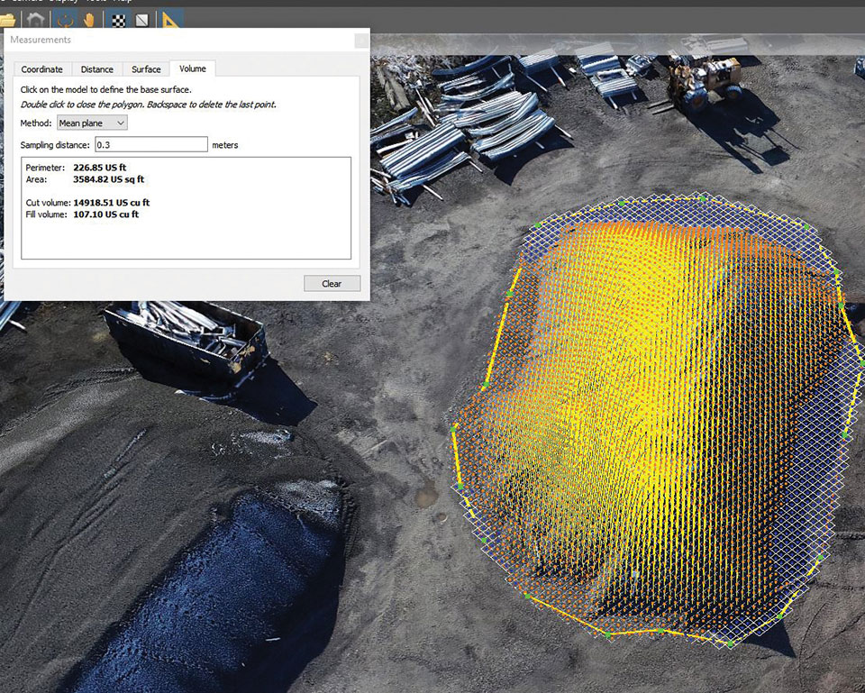
SimActive Inc., a developer of photogrammetry software, released an enhanced workflow in Correlator3D to accelerate stockpile measurement. The new capability allows users to automatically assess multiple volumes within the same project and output comprehensive reports.
If the same area is regularly flown, the new workflow also allows easy comparison of volumetric values to assess differences in time. In addition, change detection can be performed to precisely quantity variations in topography.
“Facilitating volume calculation reduces the associated costs for our clients,” said Louis Simard, CTO at SimActive. “Our new workflow is thus a definite advantage for users in multiple industries, including mining, forestry and construction.”
Kespry and DJI are partnering to offer the DJI Mavic 2 Pro drone as part of the Kespry stockpile measurement solution for mining and aggregates companies.
The solution delivers the Kespry autonomous flight and aerial intelligence experience for stockpile measurement using a DJI drone. It enables large aggregates and mining companies to standardize and capture stockpile data across all their sites in the Kespry platform, while continuing to use Kespry 2s drones to support mine and site planning operations, Kespry said.
Integration of data captured from a DJI drone is the next innovation in the development of the Kespry industrial sensor platform.
Kespry provides inventory management and mine planning data to more than 200 mining and aggregates companies. As these customers scale their use of drone data, they are looking to standardize on a single platform to organize and analyze that data across sites, geographies and product divisions — even when those sites are highly distributed, Kespry said.
The addition of the DJI Mavic 2 Pro to the Kespry lineup is designed to enable even more site data to be centralized in the Kespry cloud. It will be available with a new, cost-effective purchase point designed to support using Kespry across more sites.
“Drone data is now the standard approach for measuring stockpiles at mine sites, however, millions of dollars are wasted through reconciling inconsistent data from different platforms and the time involved getting that data ready for analysis,” said George Mathew, CEO and chairman at Kespry. “Our goal with the addition of the Mavic 2 Pro to our solution is to respond to our customers wishing to use the Kespry aerial intelligence platform across all mine sites to standardize how stockpile data is generated — lowering their costs and helping drive the profitability of every site.”
“DJI is excited to have Kespry offering the Mavic 2 Pro as part of its aerial intelligence platform portfolio,” said Jan Gasparic, director of strategic partnerships, DJI. “Pairing the Mavic 2 Pro with Kespry’s industry leading AI, ML, and analytics capabilities will be of enormous benefit to mining companies that are looking to take advantage of drone technology in a portable and powerful package.”
According to the companies, the integration of DJI’s drone and sensors into the Kespry platform is the latest innovation in the delivery of an industrial sensor network, closely following Kespry’s recently announced high-resolution thermal capabilities for industrial inspection.
This expansion in the range of data that can be explored and analyzed in the Kespry platform further enables customers to protect and maximize their assets across industrial sites.
The Kespry platform is now capable of processing and analyzing a wide range of sensor data, enabling the future creation of industry-specific applications, including those under current development with leaders in the energy sector.
“We have sites in North Carolina, Pennsylvania, Ohio and Maryland, so with the Kespry platform and DJI drone, we’ll be able to fly multiple sites at one time,” said Justin Dermont, accounting manager at Russell Standard. “I could be flying in Erie while my partners fly in North Carolina, but still be able to get the data in real time to the Kespry cloud.”
“Having DJI as part of the Kespry system will help with the flexibility and the timeliness of us being able to take inventory at multiple locations, especially when we have to take inventory at the end of production, or month end, to make sure we have accurate readings,” said Craig Schiebel, controller at Russell Standard. “Being able to take inventory simultaneously at multiple locations is huge.”
“We’re growing our business and recently acquired some new sites,” said Kyla Jungclaus, senior accountant at Brannan Companies. “We need all of our inventory to be done in just a couple days, so introducing the DJI drone to have another pilot surveying at some of our other locations will get inventory done even faster. I know that our measurements will be consistent and accurate even if I don’t do them myself, and I can manage them all in a single account in the Kespry cloud.”
Kespry is offering the Mavic 2 Pro as part of its fully-managed, end-to-end annual subscription model. Kespry customers that choose the Mavic 2 Pro for stockpile measurement will benefit from the full Kespry experience, including its acclaimed support, training, customer success team, and drone up-time guarantee.
The Kespry stockpile measurement solution with DJI will be available Q1 2019.