Tag: stratospheric

  • US Army conducts high-altitude experiments with Zephyr UAS

    US Army conducts high-altitude experiments with Zephyr UAS

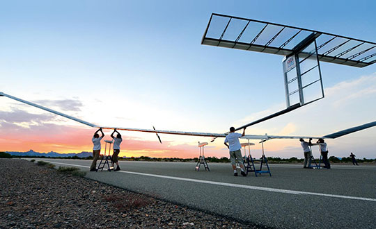
    A division of the U.S. Army Futures Command is conducting stratospheric experimentation using the Zephyr ultra-long endurance stratospheric unmanned aerial system (UAS). The tests are being carried out at Yuma Proving Ground in Arizona by he Assured Positioning, Navigation and Timing/Space (APNT/Space) Cross-Functional Team (CFT), which is based in Huntsville, Alabama.

    The first flight of 2022, launched June 15, demonstrated Zephyr’s energy storage capacity, battery longevity, solar panel efficiency and station-keeping abilities that will further the army’s goal to implement ultra-long endurance stratospheric UAS capabilities.

    During the flight, the Zephyr accomplished a number of firsts, including

    • first flight into international airspace
    • first flight over water
    • longest continuous flight utilizing satellite communication controls
    • the farthest demonstration from its launch point while carrying a commercial, off-the-shelf payload
    • breaking the world record for longest duration UAS flight (26 days) set by the same aircraft in 2018. This flight has completed 36 days and is still flying over Yuma Proving Ground.

    “Ultra-long endurance unmanned platforms have the potential to provide significant military capabilities and enhanced confidence as part of the Army’s diversified multi-layered architecture,” said Michael Monteleone, director of the APNT/Space CFT. “We have seen incredible progress in high-altitude platforms in recent years. This experimentation allows us to build on that knowledge by demonstrating multiple payload types, fully exploring the military utility of stratospheric operations, and modernizing areas of deep sensing, long-range targeting and resilient communications.”

    Zephyr is prepared for a flight test. (Photo: Airbus)
    Zephyr is prepared for a flight test. (Photo: Airbus)

    Upcoming Second Launch. A second Zephyr flight will launch in the coming weeks and travel over the Pacific Ocean. The flight will demonstrate a prototype payload, developed by the Army Futures Command, over multiple combatant commands, and continue to inform high-altitude requirements.

    The Airbus-developed Zephyr is the first high-altitude UAS of its kind, providing a persistent and adaptable longevity in the stratosphere. The experiments are performed with cooperation of the Intelligence, Surveillance and Reconnaissance (ISR) Task Force, U.S. Army Program Executive Office – Aviation, and multiple combatant commands under an Other Transaction Authority (OTA), with T2S Solutions LLC as the integrator.

    The APNT/Space CFT is responsible for accelerating the delivery of advanced APNT, tactical space and navigation warfare capabilities to the soldier. Working with a core team of experts, the CFT informs technology and system requirements through continuous experimentation and prototyping, technology integration and soldier feedback. Through this process, the APNT/Space CFT supports the Army Futures Command in delivering next-generation weapons, vehicles and equipment at an accelerated rate, giving Army forces the ability to deploy, fight and win decisively against any adversary, anytime and anywhere.

  • Stratospheric exploration craft aloft for more than a month

    World View, the stratospheric exploration company, has reached an important milestone representing a key step toward persistent and navigational stratospheric flight.

    After achieving the goal of more than 30 days aloft with full navigational control, the Stratollite completed its 32-day mission over the weekend, showcasing its enhanced long-duration flight capability.

    Before this mission, the longest Stratollite flight was 16 days, achieved in June 2019. This mission moves World View closer to scaled commercial operations, making the unique data and information sets it can provide available to commercial and government Earth-observation and remote-sensing customers around the world.

    Notable accomplishments from the mission:

    • Executed four continuous days of station-keeping (mission objective) with an average distance of 20 km from the first predetermined target location, followed by an intentional navigation to the second station-keeping target location 1,230 km away.
    • Achieved 2.5 days of continuous station keeping at the second station-keeping target with an average of 40 km from the second target location.
    • Averaged an altitude of 19.5 km during both station-keeping exercises.
    • Traveled more than 11,200 km during the mission, covering Arizona, Utah, Nevada, Colorado, New Mexico, Texas, Oklahoma, Nebraska, Iowa and Kansas.
    • Demonstrated complete navigational control during the mission from World View’s remote Mission Control in Tucson, Arizona.
    • The total mission duration was 32 days, 5 hours and 14 minutes
    • Executed more than 1,000 trajectory-control maneuvers over the entire mission.

    “This is another encouraging milestone for the team and our customers that confirms we are on the right track,” said Ryan Hartman, World View president and CEO. “It sets the stage for a challenging set of missions ahead of us as we continue to push the envelope and demonstrate the ability of the Stratollite to meet customer requirements.”

    World View’s flight operations team landed the Stratollite at a predetermined landing zone in Iowa on Saturday, Sept. 28, to conclude the mission. The system landed on command, was recovered, and will be refurbished for reuse on future missions.

    World View will continue to increase the cadence of its Stratollite flight operations. The company plans to launch multiple missions focused on demonstrating optical imaging and synthetic aperture radar sensing systems with further enhancement of station-keeping and navigational performance.


    About the Stratollite. World View’s Stratollite is a long-endurance stratospheric flight vehicle capable of station-keeping over areas of interest for remote sensing and communications.

    The craft can travel 95,000 feet above the Earth. World View is already routinely flying payloads to the edge of space for a wide variety of government, commercial, and education customers.

    World View’s proprietary altitude-control technology allows it to harness stratospheric winds to steer the Stratollite to and from desired locations and loiter above them for long durations.

    Stratollites can carry a wide variety of commercial payloads (sensors, telescopes, communications arrays, etc.), launch rapidly on demand, and safely return payloads back to Earth after mission completion.

    Among its wide variety of uses, the Stratollite will help researchers greatly advance knowledge of planet Earth, improve our ability to identify and track severe weather, and assist first responders during natural disasters.