Tag: sUAS

  • FLIR Systems acquires Altavian for defense sUAS

    FLIR Systems acquires Altavian for defense sUAS

    Photo: FLIR Systems
    Photo: FLIR Systems

    FLIR Systems Inc. has acquired Altavian Inc., a privately held manufacturer of small unmanned aerial systems (sUAS) for defense and public-safety customers.

    Altavian’s airframes integrate multiple sensors, including FLIR thermal technology, to provide users with decision support and intelligence, surveillance and reconnaissance (ISR) capability.

    Based in Gainesville, Florida and founded in 2011, Altavian designs and manufacturers Group 1 UAS solutions for long or short range operations. With both quadcopter and fixed-wing UAS designs, Altavian’s expertise includes aeronautics, avionics, and software, and its solutions are engineered around an open system architecture aligned to the needs of government and defense customers.

    Altavian is one of five drone manufacturers approved by the U.S. Department of Defense under the Blue sUAS program to sell to the U.S. military and federal agencies.

    “Altavian’s proven engineering expertise and assets will allow us to offer customers the most comprehensive solution portfolio of any American sUAS provider,” said Roger Wells, general manager of the Unmanned Systems and Integrated Solutions business of FLIR Systems’ Defense Technologies Segment, under which Altavian will be integrated. “With the addition of both a low-cost, rapidly deployable quadcopter and a longer range fixed-wing UAS, FLIR is strengthening its already impressive drone lineup, including our Black Hornet and SkyRaider platforms used extensively by militaries around the globe. We’re excited about the multiple new franchise opportunities FLIR will be able to pursue for defense, public safety, and industrial markets worldwide.”

    For more information about FLIR Systems’ existing sUAS solutions, visit flir.com/defense-uas.

  • DroneUp launches program for UAV pilot training, certification

    DroneUp is collaborating with industry leaders and government officials to promote the desired outcomes of the Federal Aviation Administration (FAA), public safety personnel, and the unmanned systems community by announcing the Responsible Community Pilot (RCP) program.

    DroneUp is a drone pilot community focused on safer skies through continuous education and sense of purpose. The announcement was made at the AUVSI Xponential show being held this week in Denver.

    The mass proliferation of small unmanned aerial systems (sUAS), specifically those operated by non-commercial pilots, has created nearly unparalleled policy, safety and legislative issues.

    To remove confusion and help increase resources available to all pilots, DroneUp is partnering with the International Association of Community Drone Pilots (IACDP) to provide tools and resources to meet the real objectives of improving airspace safety.

    By providing free access to a community-based set of guidelines and programming, the RCP program engages drone pilots through training, certification, idea-sharing and community.

    DroneUp provides the means and connections with the community to help pilots operate in the national airspace. Some of those free tools include:

    • Continually updated online courses and exams that improve regulation awareness
    • Mission-driven experiential exercises that improve piloting skills
    • An online community for questions and discussion
    • Mobile apps that verify where it is safe to fly and active advisories nearby
    • Comprehensive Standards of Conduct
    • Detailed Safety Guidelines
    • Advocacy on behalf of the community

    “Our efforts to build this community through training and a sense of purpose are having dramatic positive effects on ensuring air safety,” said Tom Walker, Founder and CEO, DroneUp. “We are dedicated to not only continuing our efforts, but to sharing collected data that will prove invaluable to officials as they draft future policies.”

    In advocating for both commercial and non-commercial use of small unmanned aircraft systems, IACDP represents commercial, recreational, military and public safety pilots.

    “IACDP is motivated by a desire to make a positive impact on the industry,” said IACDP President John Evans. “We are still growing and expanding our training, certification, and advocacy resources. We see organizations like DroneUp as valuable strategic partners for our mission.”

    To date, more than 20,000 non-commercial sUAS pilots are active members of DroneUp’s RCP community. Through affiliations with its non-profit partners, this number is expected to increase to more than 100,000 sUAS pilots over the next six months.

    Membership in DroneUp’s RCP program requires successful annual completion of the RCP training and examination online.

    Upon completion of the certification, RCP participants will receive a certificate with a unique ID number, an RCP badge in DroneUp’s mobile app; they also may request a personalized RCP ID Badge.

  • NASA issues volcano ash contract to Black Swift

    With a legacy of delivering reliable, robust, and highly accurate small Unmanned Aircraft Systems (sUAS), NASA has awarded Black Swift Technologies (BST), a specialized engineering firm based in Boulder, Colorado, the contract to develop and deliver a purpose-built scientific platform to explore volcanoes in order to improve air traffic management systems and the accuracy of ashfall measurements.

    BST will deliver to NASA a tightly integrated sUAS solution consisting of an airframe, avionics, and sensors specifically designed to measure selected gases and atmospheric parameters including, temperature, pressure, humidity, and 3D winds as well as more advanced measurements such as particle sizing and trace gases.

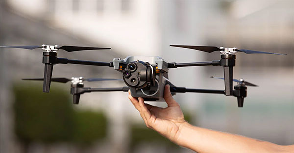
    Based on BST’s commercially available SuperSwift airframe and SwiftCore Flight Management System—which have been proven in the field to provide a cost-effective, powerful, and easy-to-operate—the SuperSwift XT [figure 1] is specifically engineered to meet the demands of high altitude flights through strong winds and damaging airborne particulates typical of nomadic scientific field campaigns in harsh environments.

    “NASA and similar scientific agencies require deliverables with a high degree of accuracy and reliability,” emphasizes Jack Elston, Ph.D., CEO of Black Swift Technologies. “The SuperSwift XT will be designed to collect data in harsh environments and will enhance the performance and utility of NASA’s Airborne Science fleet.”

    Member organizations of NASA’s Airborne Science Program can all benefit from the measurements provided by this system in various atmospheric conditions using different sensor payloads which, by design, are easily interchangeable. The sUAS will provide targeted, in situ observations from previously inaccessible regions that can significantly advance NASA’s goal of safe, efficient growth in global aviation by aiding in the collection of scientific data from which predictive Volcanic Ash Transport and Dispersion models (VATD) can be used to inform air traffic management systems.

    Leveraging BST’s proprietary Mission Planning Software, scientists can program the SuperSwift in minutes to calculate the area under review and then begin collecting data for immediate analysis and decision making. With its intuitive tab-driven interface, flight planning is simple and easy to accomplish.

    Mission monitoring and mapping is all done from a handheld Android Tablet loaded with BST’s SwiftTab software. Gesture-based controls enable users to confidently deploy their SuperSwift with minimal training while being able to collect data over geography that is topically diverse with confidence.

    The existence of a sUAS capable of carrying the necessary instruments routinely through harsh environments adds an invaluable contribution to the calibration and validation of data collected from ground- and satellite-based methods. The flight envelope, concept of operations (CONOPS), and rugged nature of the SuperSwift XT will permit researchers to collect data previously unobtainable through traditional data collection methods or existing sUAS.

    This includes gathering difficult to obtain data sets such as from volcanic plumes shortly after eruption (i.e., particle size-frequency distribution, vertical ash concentration distribution, SO₂ flux, etc.).

    The innovations of the SuperSwift XT, including the total sensor suite, can be utilized for scientific research by federal and state public agencies and other state-funded laboratories to collect data on coherent atmospheric structures such as smog, volcano plumes, wildfire smoke, chemical fires, forest humidity, etc.

    Commercial applications for private industry exist as well, such as utilizing the SuperSwift XT to assess the composition, and relative danger, of chemical fires at refineries or the chemical composition of smokestack exhaust.

  • uAvionix debuts pingRX receiver for small drone collision avoidance

    pingRX-receiver-auvsiElectronics manufacturer uAvionix has introduced the smallest and lightest ADS-B receiver, according to the company. The new pingRX weighs 1.5 grams and requires one hundredth the power of conventional ADS-B (Automatic Dependent Surveillance – Broadcast) receivers. It implements “sense and avoid” capabilities for small drones operating in the National Airspace (NAS).

    The receiver, for use in small drone collision avoidance systems ADS-B, helps aircraft operators sense and avoid possible collisions. ADS-B is mandated by the U.S. Federal Aviation Administration for all aircraft in the NAS in 2020. Used now primarily on manned aircraft, miniaturizing the equipment was essential to make it useable for small drones, uAvionix says. pingRX measures 32 by 15 by 3 millimeters, which is a fraction of the size of earlier units.

    Early adopter Randy Mackay, lead developer of ArduCopter, said to the company that it “feels slightly magical to have real aircraft appearing on our ground station map.”

    pingRX receives ADS-B information broadcast by other aircraft on two frequencies approved by the FAA (978 megahertz and 1090 megahertz). This allows the unit to detect commercial aircraft threats within a 100 statute mile radius in real time.

    For drone aircraft system installation, pingRX is designed for direct MAVLink integration with Pixhawk autopilots and APM Mission Planner software.

    uAvionix will display its new patent-pending pingRX ADS-B receiver at the Association for Unmanned Vehicle Systems International’s Xponential trade show May 3-5 in New Orleans.