Esri is partnering with the Jane Goodall Institute to develop a set of tools that will help communities map and manage the ecosystems around them through a collaborative design and planning approach, aided by GIS software.
According to the partners, these tools will help communities map, monitor, and better manage their natural resources from community forests and wildlife reserves, to water catchment and flood control areas, as well as human settlement, agriculture and agroforestry spaces.
The Jane Goodall Institute’s community-centered conservation approach — Tacare — partners local communities and governments to create sustainable livelihoods while planning for and advancing environmental protection. The Tacare approach also achieves conservation results and addresses environmental threats — including incompatible expansion of agriculture, human settlements, harvesting forest products, disease, wildlife trafficking and illegal bushmeat trade — by consulting communities about their needs and priorities, and working together to collaboratively plan for and implement land use practices that enable their own development.
“A key component of our success is that we work to help villagers find ways to make livelihoods that do not destroy the environment, and help them understand that protecting the environment not only conserves wildlife, but their own future,” said Dr. Jane Goodall, DBE, founder of the Jane Goodall Institute and United Nations Messenger of Peace.
The Jane Goodall Institute uses Esri’s ArcGIS platform and Survey123 mobile app to help communities and governments in western Tanzania, Uganda and other countries in Africa to plan, monitor and protect chimpanzee populations in local protected forests outside designated national parks.
“Conservation at the community level is essential to sustaining our natural world,” said Jack Dangermond, Esri founder and president. “Protecting global ecosystems cannot work on a global scale unless it starts locally, which is why we are honored to work with our friend and partner, the Jane Goodall Institute, on this collaboration, leveraging their years of experience working at the local scale in pursuit of conservation, balanced with the needs of human communities.”
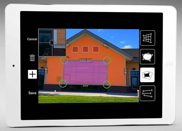
The new software release of Survey123 for the ArcGIS mobile application now has Spike, a laser measurement solution by ikeGPS.
The paired technology dramatically accelerates field data capture and asset inspection activities.
Spike allows users to measure hard-to-reach objects from a distance by taking a photo with their smartphone or tablet. Users can then capture real-time measurements from that image, including areas, elevations, distances between two points, and GPS/GNSS location.
Use of the Survey123 integration with Spike will be of interest to organizations that use mobile workflows for asset and facilities management, field asset inventories and inspections, damage assessments, and tactical operations including disaster response.
Using Spike with Survey123 relieves fieldworkers of the burden of carrying paper maps to find the object of interest and lugging multiple pieces of specialized, expensive measuring equipment. Instead, with a single mobile device, fieldworkers can locate the correct asset, record measurement data, and report accurate data directly back to the office.
“The new Spike integration with Survey123 is a game changer for many field data collection and inspection workflows where the dimension of physical objects needs to be captured. Spike and Survey123 provide quick return on investment,” said Ismael Chivite, Esri product management lead. “The simplicity of the solution enables it to be quickly deployed and with little training. Customers are very enthused about this low-cost solution that will streamline many of their critical workflows.”
The ability to capture accurate measurements in the field is particularly useful when working in areas that don’t lend themselves to hands-on or close-up measurement. Spike’s laser can be used in ranges from 6 to 650 feet, with the option to select units of measurement in inches, feet, meters or centimeters. With it, a single fieldworker is able to more quickly and safely accomplish what may otherwise have taken multiple field staff and costly equipment.
The Spike laser device mounts to smartphones and tablets and connects via Bluetooth with the mobile device’s camera.
Survey123 with Spike runs on Apple iOS and Google Android smartphones and tablets.
Last week, Esri held its 36th International User Conference in San Diego. With 15,000+ attendees from 130 countries, it is the largest gathering of geospatial professionals in North America.
The general plenary presentation on Monday morning is always an interesting event. Founder Jack Dangermond leads the plenary and presents his vision for the year, and years, to come. Here’s the opening Plenary video (3 minutes):
The message of this year’s Plenary was “Applying Geography Everywhere” with the central theme was Web GIS. Here is a video of Mr. Dangermond’s GIS vision (12:42 minutes):
For the past few years, he’s spoken quite a bit about the democratization of geography by making GIS capability available to an audience other than the GIS professional by expanding its impact across an organization at many levels. Here’s a slide he’s presented in the past, and I think it’s consistent with where he sees GIS heading; a global awareness and global usage of GIS apps and data.
Esri thinks that Web GIS is an enabling technology that will be a catalyst for the democratization of GIS across all of an organization’s departments.
How GIS has evolved. (Credit: Eric Gakstatter)
During the Plenary, Bern Szukalski outlined Esri’s take on the current trends in Web GIS:
Portals. The windows into GIS. Thousands of public and private portals serve up GIS data and services.
Content. A collection of authoritative and curated content that Esri calls a living atlas, with some data being updated daily or even hourly.
Analysis tools. For the non-GIS professional to answer simple (or complex) queries such as emergency services coverage in a particular municipality, leveraging the living atlas content to use the most up-to-date data.
Smart mapping. New data-driven web cartography functionality and data exploration that leverages the right tools presented at the right time. Think of it like Google search that shows you relevant web sites based on your past web surfing.
Story maps. A combination of Web GIS and rich media to tell a compelling story. A new and unreleased type of Story map presented by Bern is the Story map Cascade, an immersive experience as you advance through the story and interact with map, amplifying the value of GIS.
If you want to view Bern’s plenary presentation on Web GIS trends, see the following 9-minute video:
Esri Product Roadmap
I get the feeling that ArcGIS Pro will be Esri’s premiere desktop product. When you buy ArcGIS, in addition to ArcMap, you also get a concurrent license for ArcGIS Pro (and ArcGIS Online), and you can see from the following slide that ArcGIS Pro incremental upgrades follow ArcMap. The following slide also shows the timing for the ArcGIS 10.4 release.
Another product Esri is going to release later this year to further promote the democratization of digital geography is a product called ArcGIS Earth. Just by the name, you can imagine the type of product it’s going to be. It’s all about 3D visualization.
Lastly, many of you may have missed the discussion about a new Esri Mobile GIS app called Survey123. There wasn’t a big announcement made, but it seems to be a powerful little app. For those of you who think Collector is a bit too structured, Survey123 might be the app for you. You can easily author smart forms following the XLSForm specification and quickly set up data-collection workflows. This is a really neat feature of Survey123, because you can create your mobile GIS data-collection pick lists and use form logic in an Excel spreadsheet instead of having to create it in the Esri environment.
It might end up being my favorite Esri mobile GIS app. But, you’ll have to wait to give it a spin because it’s not slated for release until later this year.
In other mobile GIS news at the conference, it appears as though Microsoft is concerned about Android and iOS dominating the mobile device space, so much so that Microsoft co-founder Bill Gates made a recorded presentation at the plenary. Even more interesting is that Mr. Dangermond suggested that perhaps Mr. Gates might make a live appearance at the Esri UC sometime in the future.
Bill Gates delivers an address to the Esri plenary audience. (Photo: Eric Gakstatter)
On the technical side of Microsoft, it looks like the end is in sight for the separate software development platforms for Windows Desktop and Windows Phone. With Windows 10, I heard that the software development environment for Windows Desktop and Windows Phone (or whatever it’s going to be called) is going to be the same, so you should start seeing Windows devices pick up some momentum next year.