Note: In May 2013 this newsletter published a column on “What’s New in GNSS Simulation.” This month, Editor Tony Murfin takes a brief look at a new start-up in GNSS simulation, Skydel, and its software signal simulator. We also provide quick updates on the latest from those simulation companies and others.
Skydel
Software-defined simulator
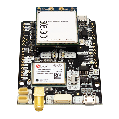
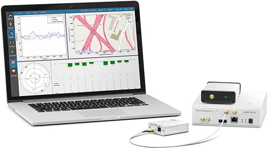
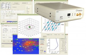
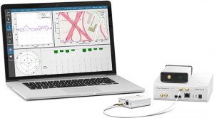 Skydel provides a software-defined simulator using generic hardware to accommodate system integrators who may have a consumer product or application with GNSS inside, and may not require a full-function simulator. Skydel uses a regular GPU to perform modulate the GNSS signal. The computer can be a laptop or desktop, but must include an Nvidia graphics card. The Universal Software Radio Peripheral (USRP) here is the Ettus N210. Skydel also uses the bladeRF x40 made by nuand, an alternative USB 3.0 Software Defined Radio, and Averna RP-6100 Record & Playback system.
“What’s New in GNSS Simulation” Updates
Spirent
Spirent debuts practical PNT framework for more robust position, navigation and timing systems
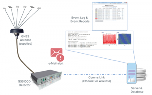 Threats to GNSS and related PNT applications are more orchestrated and coordinated, with the motivation to disrupt or cause financial loss. The technology to disrupt GPS has also become much more accessible, resulting in GPS vulnerability even gaining attention at hacker conventions. Spirent’s GNSS Interference Detector System helps users solve these problems.
Rohde & Schwarz
Solutions for all aspects of LBS testing
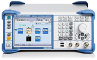 Need to verify your location based service (LBS) applications based on A-GNSS, OTDOA and eCID? Rohde & Schwarz offers a wide range of testing solutions for all aspects of LBS testing, including protocol conformance, minimum performance and OTA. Applicable from development and production to installation, the solutions support the positioning techniques and protocols deployed by mobile network operators.
CAST
CAST lightweight GPS Satellite Simulator
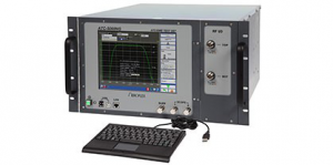
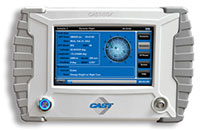 With its compact size of 7 x 11 x 3 inches and weighing in at just over four pounds, the SGX is CAST’s smallest fully capable simulator to date. The SGX lightweight portability features 16 channels of L1 C/A and P codes and is extremely accurate and repeatable. Features include a touchscreen, individual satellite power control and start-and-stop scenarios with the touch of a button.
Spectracom
GNSS Simulator Compatible with IRNSS and QZSS
 Spectracom’s GPS/GNSS simulator is now available for testing receiver compatibility with India’s global navigation satellite system, IRNSS, and Japan’s regional satellite system, QZSS. The Spectracom GSG-6 Series multi-frequency GNSS signal simulator is designed to be field upgradeable to readily enable the addition of all current and future GNSS constellations.
iFEN
SX3 GNSS Software Receiver
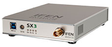 The SX3 Black Edition is a modular dual-RF multi-GNSS software receiver with superior flexibility and performance, whether processing the dual-RF front-end data stream in real-time or post-processing IF samples from storage. Graphical user interface provides easy access to signal processing configuration properties and gives real-time feedback for channel output, correlation function and RF spectrum.
RaceLogic
The 2015 leap second – LabSat scenarios now available
 With the LabSat 3 Simulator you can reliably test your products on the bench to see how they cope with events such as the leap second, alongside standard issues such as multipath and signal obscuration. Recordings of the leap second from the three main constellations are now available for use with LabSat 3.
IP-Solutions
Replicator
 GNSS RF simulator, recorder and playback device — inexpensive, economical, flexible, with a high-fidelity GNSS simulation solution. This product was originally developed cooperatively for JAXA (Japan Aerospace Exploration Agency). Originally developed for, and in cooperation with, the Japan Aerospace Exploration Agency (JAXA).
Cobham AvComm
ATC-5000NG NextGen ATC/DME Test Set
 Formerly the Aeroflex AvComm business unit, Cobham introduced this year the ATC-5000NG NextGen ATC/DME Test Set, an RF signal generator/receiver for testing Mode A, C and S transponders. The ATC-5000NG was designed with modern software-defined radio technology for engineering development, design validation, manufacturing and return-to-service testing.
TeleOrbit
GIPSIE
 TeleOrbit’s software-based GNSS multi-system performance simulation environment, GIPSIE, consists of a satellite constellation simulator and an intermediate frequency simulator. The digital signal simulator GIPSIE streams the software-generated signals or recorded live data exactly into the receiver’s baseband processing chain to support development, test, verification, validation, qualification and certification.
Averna
RP-6100
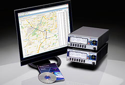
 The Averna RP-6100 Multi-Channel RF Record & Playback for RF application testing allows users to to record real-world signals such as GNSS, HD Radio, LTE and Wi-Fi, plus impairments, to advance projects and harden product designs. Frequency range of 10–6000 MHz, up to 4×40 MHz or 2×80 MHz bandwidth, 14-bit resolution, tight channel synchronization. Records up to 22 hours, supports Skydel’s software-defined, real-time GNSS Simulator.
Syntony GNSS
Syntony RTG2 Constellation Simulator
 Syntony offers the RTG2, a GNSS constellation simulator that generates realistic GNSS RF signals, taking into account the current and future GNSS constellations. The generator is entirely configurable (troposphere and ionosphere effects, simulated receiver trajectory, etc) through a user friendly interface accessible on a separated PC through Ethernet.