An independent technical review published earlier this month found sufficient data in three government-conducted tests to assess the risk of using frequencies near the GPS band for a ground-based communications network — specifically, the one proposed by Ligado Networks. The panel rejected two tests sponsored by Ligado Networks, saying they did not meet minimum criteria for inclusion or use.
The testing and various hearings before the Federal Communications Commission (FCC) come in response to increasing demand for commercial spectrum to support broadband wireless communications. The FCC and other branches of U.S. government are giving serious consideration to repurposing various radio frequencies, including the satellite communications bands next to GPS, to accommodate this.
Ligado Networks has petitioned the FCC to repurpose satellite frequencies near GPS to also support terrestrial telecom services, effectively transferring its license for space-based broadcasting to powerful terrestrially-based broadcast towers. Ligado’s custom networks would provide services for industrial operations such as power grids and connectivity for drones and driverless cars, in addition to consumer broadband services.
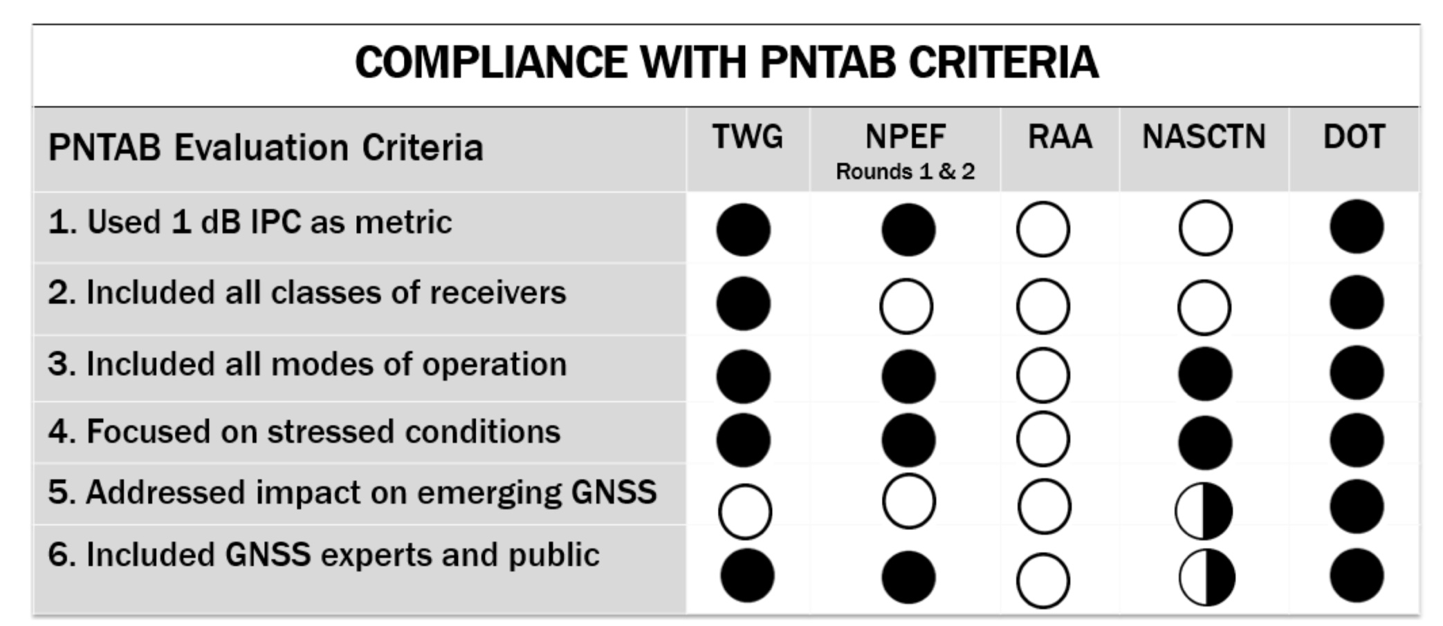
The National Executive Committee of the government’s National Coordination Office for Space-Based Positioning, Navigation, and Timing released the assessment by its National Space-Based PNT Systems Engineering Forum (NPEF) of testing methodologies used to analyze the impacts of adjacent band interference on GPS receivers. The assessment is also known as the “gap analysis.”
The NPEF evaluated five tests performed by the following organizations, the first three of them government organizations and the last two private tests sponsored by Ligado with little or no public or government input:
Federal Communication Commission (FCC)-mandated Technical Working Group (TWG) — done in 2011.
National Space-Based PNT Systems Engineering Forum (NPEF) — done in 2011.
Department of Transportation (DOT) Adjacent Band Compatibility (ABC) — done in 2017 but not previously released.
Roberson and Associates (RAA)
National Advanced Spectrum and Communications Test Network (NASCTN).
The gap analysis concluded that the results from the first three tests are sufficient and appropriate to inform spectrum policy makers on the major impacts of a proposed LTE network on GPS receivers. The DOT test results revealed the power levels that GPS and GNSS receivers can tolerate from interference sources in the adjacent band in an effort to inform the enforcement of a GPS interference protection criterion.
PNT Advisory Board’s set of minimum criteria. The two Ligado-sponsored tests are the RAA and the NASCTN. (Image: PNTAB)
The NPEF team found the scope and framework of the last two tests, sponsored by Ligado, to be insufficient when evaluated against the PNT Advisory Board’s set of minimum criteria. Key among these criteria is one that specifies use of the internationally accepted 1 dB degradation Interference Protection Criterion (IPC): a one-decibel (1 dB) degradation in C/N0, the carrier-to-noise power density ratio. Ligado has tried to redefine the standard measurement of interference to one more in its favor: a change in positioning and timing accuracy.
For further background on this and other aspects of the gap analysis, see the January 2018 GPS World article by Brad Parkinson, “A Grave Threat to GPS and GNSS.”
The NPEF strongly recommended that decisions impacting the GPS radio frequency environment be informed by data from tests that align with the PNTAB’s set of minimum criteria and with full consideration of the potential operational, scientific, and economic impacts.
The full gap analysis study can be downloaded here.
The NPEF is co-chaired by the Departments of Defense and Transportation and consists of representatives from at least 14 federal agencies.
The fully digital Mission Data Unit (MDU) will create precise civil and military timing navigation signals for GPS III satellites 11 and beyond. Pictured here is the advanced MDU on navigation payloads being delivered for GPS III Space Vehicles 1-10. (Photo: Harris)
Harris Corporation has completed development of its fully digital Mission Data Unit (MDU), which is at the heart of its navigation payload for Lockheed Martin’s GPS III satellites 11 and beyond.
Harris has already provided MDUs and payloads for the first 10 GPS III satellites, one of which has been declared “available for launch” and the second of which is completing its testing. The other eight are in various stages of production assembly.
Payloads for the satellites 11 and beyond bring further signal transmit capabilities, providing more powerful signals and built-in flexibility to adapt to advances in GPS technology, as well as future changes in mission needs.
The new MDU that will eventually go aboard satellites 11+ “can be upgraded incrementally over its mission life due to built-in adaptability,” according to a Harris spokesperson.
GPS OCX
The U.S. Air Force Space and Missile Systems Center has accepted delivery of the GPS Next Generation Operational Control System (GPS OCX) Launch and Checkout System (LCS) baseline from Raytheon Intelligence and Information Systems. Also known as Block 0, LCS demonstrated conformance through test and analysis with all contractual requirements. OCX Block 0 is the foundation for Raytheon’s future Block 1 and 2 delivery, slated for 2022.
LCS is a fully modernized cyber-secure ground system complete with the computing hardware, operations center workstations, and mission application software necessary to launch the first GPS III satellite into orbit and perform initial on-orbit testing.
Mission operators are now using LCS in the GPS III Mission Readiness Campaign. The ground system is performing as expected during the rehearsals and space vehicle checkout.
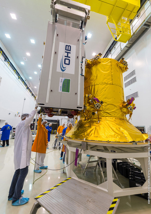
Galileo Launch
A Galileo satellite undergoes its fit-check validation at the Spaceport. Flight VA240. (Photo: ESA/Arianespace)
As this magazine goes to press, final preparations are underway for Galileo’s quadruple launch on Dec. 12. The Ariane 5 rocket has completed its build-up at the spaceport in French Guiana and is moving toward payload integration and rollout to the launch zone.
The four 700-kilo (1,543-pound) Full Operational Capability (FOC) Galileo satellites have completed checkout and one-by-one verification of their interfaces with the payload dispenser that will release them once aloft in mid-Earth orbit.
They will soon take on fuel for their long space life.
The satellites will bring the Galileo operating constellation to 22, and, according to the European Space Agency, this will provide availability to users anywhere in the world for a high-quality position solution — defined as position dilution of precision (PDOP) less than 5 — 99.8% of the time.
The European Space Agency (ESA) and the U.S. National Aeronautics and Space Administration (NASA) are conducting a joint GPS/Galileo space receiver experiment onboard the International Space Station (ISS). This will be the first time that a combined GPS/Galileo receiver will operate in space.
The project aims to demonstrate the robustness of a combined GPS/Galileo waveform uploaded to NfASA hardware already operating in the challenging space environment: the Space Communications and Navigation (SCaN) software-defined radio testbed.
Testing activities include analysis of the GPS/Galileo signal and onboard position/velocity/time (PVT) performance; processing of code- and carrier-phase GPS/Galileo raw data for precise orbit determination (POD); and validating the added value of a space-borne dual-GNSS receiver compared to a single-system receiver under the same conditions.
This collaboration was initiated in 2014 and a Technical Understanding was signed in 2016.
Many new space applications may not be possible if constrained to using the limited signal availability associated with any single constellation of GNSS satellites.
This research therefore seeks to demonstrate the enhanced capabilities brought by the use of satellites from two or more GNSS constellations in the space domain. The net result will be more resilient space operations, greater mission flexibility, and enhanced PVT performance.
The project is currently in the testing and verification phase, and it is expected that the final implementation of the combined GPS/Galileo waveform on NASA’s SCaN Testbed on-board the ISS will be completed in September/October 2017, so that the initial operations of the first combined GPS/Galileo receiver in space can start in the October/November 2017 timeframe.
The researchers plan to present preliminary results at the UN International Committee on GNSS (ICG)-12 in Kyoto, Japan in December.
From ESA’s side, ESOC’s Navigation Support Office (NavSO) and ESTEC Experts for Radio Navigation Systems and Techniques (TEC-ESN) are involved in this project.
The overall project management from ESA’s side and POD aspects are covered by NavSO, and ESTEC’s Technical Directorate is in charge of the Galileo waveform development and implementation of the SW on the FPGA in cooperation with NASA. This activity is done with technical support from industry participants such as Qascom. Industry participation is a vital component as new markets for multi-GNSS receivers and complex space applications continue to emerge.
From NASA’s side, the project is sponsored by the Space Communications and Navigation (SCaN) Program within the Human Exploration and Operations Mission Directorate (HEOMD) at NASA Headquarters in Washington D.C. Integration and experimentation activities are being performed by the NASA Glenn Research Center.
NASA has initiated an international effort within the ICG to develop a fully interoperable multi-GNSS Space Service Volume (SSV), where a combination of constellation services will be available well above low-Earth orbit (LEO) to support newly emerging geostationary Earth orbit (GEO) and high-Earth orbit (HEO) missions — ranging from more precise station keeping to extend GEO belt capacity and maneuver recovery to enabling formation flyers and satellite servicing operations.
WERNER ENDERLE is head of Navigation Office, Ground Systems Engineering Department at the European Space Operations Centre of the European Space Agency.
JAMES J. MILLER is deputy director, Policy & Strategic Communications – Space Communications and Navigation in the Human Exploration and Operations Mission Directorate at NASA headquarters.
Anomalous GPS Signals from SVN49
By Fabio Dovis, Nicola Linty, Mattia Berardo, Calogero Cristodaro, Alex Minetto, Lam Nguyen Hong, Marco Pini, Gianluca Falco, Emanuela Falletti, Davide Margaria, Gianluca Marucco, Beatrice Motella, Mario Nicola and Micaela Troglia Gamba
Researchers at the Navigation Signal Analysis and Simulation (NavSAS) Group of the Politecnico di Torino detected in mid-May the presence of anomalous spikes in the L1 signal spectrum. The origin of the spikes was identified to be transmission of a non-standard code from a non-operational GPS satellite (GPS IIF-9, SVN49). Here we report on signal observations and address possible impacts on GNSS signal processing.
On May 17, 2017, during outdoor data collection, NavSAS researchers detected two spikes in the L1 spectrum, with sufficient power to be clearly visible on a display processing raw digital samples at the receiver’s intermediate frequency.
An initial check looked for a possible interfering source in the experimental set-up, since it was quite complex with multiple pieces of electronic equipment. The likelihood of this source was soon dispelled as the same kind of spectrum was visible on a spectrum analyzer (SA) connected to an active survey-grade GNSS antenna on the lab roof; results shown in FIGURE 1.
The spectrum is centered at 1575.42 MHz, with the SA set to a frequency span of 5 MHz. Connecting the SA to different survey-grade antennas on the roof, we found no remarkable differences. The spikes continued to appear on subsequent days, becoming clearly visible around 13:00 UTC and disappearing around 19:00 UTC.
Figure 1. L1 Spectrum of the received signal at 16:51 (Central European Summer Time; 14:51 UTC) on May 19, 2017, at the NavSAS Lab, Torino (located at 45°03’54.98767″ N, 7°39’32.28920″ E, 311.9667 meters).
Exclusion of Terrestrial Sources. The 24-hour repetition period of the phenomenon, along with the shape of the spectrum, could indicate the presence of a signal anomaly from a GNSS satellite. In a battery of tests, we probed the L1 spectrum in a wider area using assorted equipment.
For various reasons, we ended up focusing on a non-operational satellite: SVN49, launched March 24, 2009. We concluded that transmission of a non-standard code (NSC) from this satellite was the origin of the problem in the L1 spectrum.
Transmission of NSCs for testing purposes is foreseen in the GPS Interface Specification, IS-GPS-200. GPS satellites can switch off regular broadcasts of C/A code and P/Y code and transmit a non-standard C/A code and non-standard Y code.
Such operation is intended to protect users from receiving and utilizing erroneous satellite signals in case of unhealthy conditions on the spacecraft. Strictly speaking, this case cannot be formally considered as an “anomaly,” because the transmission of non-standard codes is documented in the IS-GPS-200.
Therefore, the transmission of an NSC can be considered a normal operation in itself, though it may reflect a problem with the transmitting satellite.
In this case the choice of the spreading sequence, which is likely a square wave, allowed the total power of the signal to be concentrated in just a few spectral components, thus originating continuous-wave-like in-band signals.
The distribution of the harmonics, the main components of which are at ±500 kHz, and the presence of the odd harmonics only, matches an earlier case in 2006 of a transmission of an NSC modulated as a binary-phase-shift-keying (BPSK) sequence with alternating logical 0s and 1s, transmitted at the C/A code chipping rate (Rc=1.023 megachips per second). The hypothesis of the BPSK with Rc=1.023 megachips per second spreading signal has been verified by simulation.
However, the NSC is designed to have negligible effect on tracking other healthy GPS satellite signals. Nonetheless, an NSC transmission can have a non-negligible impact in performance of user equipment.
When a GPS satellite is switched to NSC mode, a receiver immediately loses its capability to track that satellite signal. This is not the case with SVN49, as it is currently declared non-operational. However, due to the modified code sequence, a further effect is possible: the NSC introduces irregular components at a sustained level in the GPS signal spectrum.
According to Notice Advisory to Navstar Users (NANU) 2017001, SVN49 was broadcasting standard signals as PRN04 (though set unhealthy) since the beginning of the year; NANU 2017042 announced that PRN04 was to be re-allocated to SVN38 on May 18.
This switch matches the dates when we started to see the spikes, since, probably, SVN49 started that day to use the “square wave” for the spreading.
Implementing the square wave local code, it has been possible to successfully acquire and track the NSC.
The real-time software receiver N-Gene has been forced to acquire and track in real time the signal coming from SVN49. The receiver decoded the navigation message transmitted by SVN49, which exhibits a regular format, even if marked with an unhealthy flag.
Impact on Receiver Processing. Interference with harmonic components such as those generated by the use of a square wave could strongly impact a GNSS receiver in the acquisition and tracking blocks, because the interference power is dispersed over the whole search space by the correlation with the local code, compromising the acquisition accuracy and impacting other functional blocks.
The impact of interference spectral lines depends on their location within the frequency band. This is due to the almost periodic nature of the GNSS signals. The spectrum of a GNSS signal has components spaced at multiples of the inverse of the code period (for example, 1 kHz for GPS C/A code) with different power allocated to each component depending on the shape of the code spectrum.
The effect is larger in the case of matching of the interference spectral components with the ones of the GNSS signal. Furthermore, in this case, the strongest harmonics are close to the L1 carrier frequency and are not mitigated by the front-end filter since they fall within its narrow bandwidth.
The overall GNSS scenario has changed a lot recently. Galileo and BeiDou are also present, and Galileo signals, due to the different structure and code periods, have spectral lines spaced at 0.25 kHz. The frequency modulation of the interfering signal due to the variable Doppler shift is thus even more likely to hit some of the spectral components of these signals.
We are investigating further to assess the impact of the interfering signal from SVN49 on Galileo-based high accuracy applications.
U.S. Air Force Response
The 2nd Space Operations Squadron is performing maintenance on a presently non-operational satellite. SVN49 is broadcasting non-standard C/A and non-standard Y codes as described in IS-GPS-200. Space professionals continue to conduct safe and responsible command and control of the constellation to continue to provide accuracy that exceeds established system requirements.
As always, GPS users who experience issues should address them through the appropriate channels: military users should contact DSN 560-2541, commercial 719-567-2541 while civilian users should contact the U.S. Coast Guard Navigation Center at 703-313-5900.
Very Respectfully,
Nicholas J. Mercurio, Capt., USAF Director, 14th Air Force/JFCC SPACE Public Affairs
The U.S. Senate Armed Services Committee withheld the full amount requested by the Pentagon for Fiscal Year (FY) 2017 for OCX, the Next-Generation Operational Control System (ground control) for GPS, heretofore deemed necessary to operate the next generation of satellites, GPS III. The Pentagon had asked for $394 million in the upcoming funding cycle, to enable Raytheon to continue work on the program.
If allowed by Congress to continue, OCX may cost as much as $5.3 billion, and there is no certainty that the bill will not rise further.
The Senate committee will not release the $394 million until the Defense Department complies with the requirements of the Nunn-McCurdy Act governing defense programs. Otherwise, Congress could act to terminate OCX.
The terms of the Act now require the Secretary of Defense to conduct an in-depth review and then state that the program is essential to national security, is more important than other programs that will have to be cut to accommodate its cost overruns, and that there are no acceptable alternatives.
From the Defense Department point of view, the new GPS III satellites are essential because of, among other things, their signals’ improved resistance to jamming and cyberattack, an oft-cited peril in the modern global security scenario.
How GPS III could be launched — the first satellite is scheduled for sometime in 2017 — and operated without OCX is not entirely clear, although in February, Lockheed Martin received a $96 million contract to provide contingency control operations for the first GPS III satellites upon launch because OCX won’t be ready. Raytheon and the U.S. Air Force announced a month ago that OCX “successfully passed the first formal qualification test milestone” needed to check out the system and for the early monitoring of satellites in orbit. That “validates the maturity of the OCX launch and checkout system,” according to a statement by Bill Sullivan, Raytheon’s OCX program director.
Raytheon won the OCX contract in 2010 with a bid somewhat more than $1.5 billion. The Air Force recently made its FY 2017 budget request for $393 million as part of an overall anticipated program cost of $4.82 billion. However, a Bloomberg news report states that the total cost may have risen to $5.3 billion.
Galileo Launch and Production
At press time, the latest pair of Galileo satellites was expected to launch into orbit on May 24: the 13th and 14th satellites in the constellation.
A second launch is planned for this fall, carrying four satellites aboard a customized Ariane 5 for the first time. This would bring the count to 18 Galileo satellites in orbit by the end of the year.
Final Payload Delivered. Surrey Satellite Technology Ltd. in the United Kingdom has delivered the 22nd Galileo navigation payload to prime contractor OHB System in Bremen, Germany. This is SSTL’s final payload under Galileo Full Operational Capability (FOC) Works Orders 1 and 2.
Europe’s 13th and 14th Galileo satellites lifted off at 08:48 GMT from Europe’s Spaceport in French Guiana atop a Soyuz launcher. (Photo: ESA)
BeiDou 30 over 5
China plans to launch 30 Beidou navigation satellites during the five-year period 2016–2020, said Ran Chengqi, director of the China Satellite Navigation Office, during the China Satellite Navigation Conference in early May.
This would realize the country’s three-step strategy to build a global navigation system by 2020. A batch of 18 satellites will be launched before 2018. China and Russia have agreed to make BeiDou and GLONASS compatible, and BeiDou has successfully synchronized its frequency with Galileo, Chengqi added.