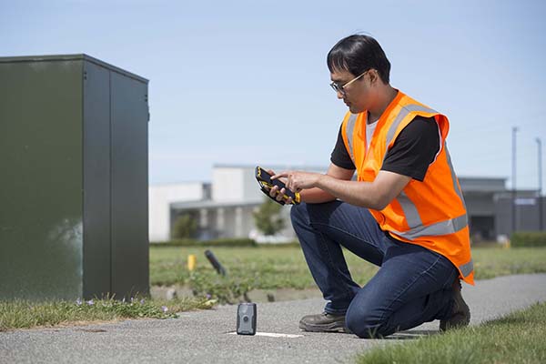
TDC’s Freeance field applications leverages Trimble GNSS for accurate, streamlined data collection
TDC Group has joined Trimble’s GIS (geographic information system) Business Partner Program. As part of the program, TDC has implemented the Trimble Precision SDK (software developer kit) to integrate high-accuracy positioning capabilities in its Freeance mobile software applications running on tablets and smartphones using Trimble GNSS receivers.
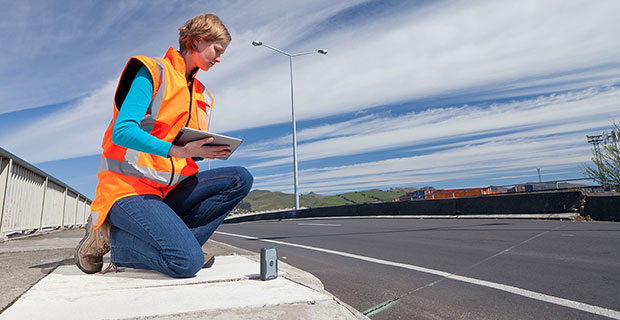
Freeance provides field crews with simple yet powerful and configurable location-based mobile apps to manage data collection and inspection activities across utility and public works organizations. By adding the Trimble R1 and R2 receivers to Freeance workflows, users are empowered with real-time access to high-quality, reliable data.
The Trimble R1 receiver will be accessible with TDC’s Freeance software. (Photo: Trimble)
“Trimble recognizes the value our GIS software partners bring to our customers by delivering targeted, industry-specific solutions,” said Stephanie Michaud, strategic marketing manager, Trimble Survey & Mapping Field Solutions. “We’re very pleased to collaborate with TDC and leverage their domain expertise, and to integrate Trimble technology into the Freeance solution for the utilities and public works markets. As a direct result of this relationship, Freeance users can now work with the confidence of knowing their field workflows are precision-enabled with Trimble GIS technology.”
“We’re excited about the integration of high-accuracy Trimble GNSS receivers with Freeance software that enables organizations to add sub-meter or better accuracy to mobile workflow activities using smartphones and tablets,” said Matthew Reddington, CEO of TDC Group. “Adding high-accuracy positioning to field workflows by means of simple mobile apps paired with Trimble GNSS increases the quality and uses of data captured during field operations.”
The Trimble Catalyst software-defined GNSS receiver for Android devices is now available through Trimble’s global distribution network.
Trimble Catalyst DA1 antenna attaches to a smartphone running a Catalyst-enabled app.
Through Catalyst and a special antenna, customers can access positioning-as-a-service to collect geolocation data with Trimble or third-party apps on smartphones, tablets and mobile handhelds.
When combined with a plug-and-play digital antenna and subscription to the Catalyst service, the receiver provides on-demand GNSS positioning capabilities to turn consumer Android devices into centimeter-accurate data-collection systems.
Catalyst requires only a few components:
Any location-enabled mobile app.
A Catalyst subscription, with accuracy options ranging from one meter to centimeter level.
Trimble’s small, lightweight DA1 antenna that plugs directly into Android smartphones and tablets.
“Our goal has always been to extend the accessibility of high-accuracy positioning to a broader base of geospatial and non-geospatial professionals,” said Ron Bisio, vice president of Trimble Geospatial. “Trimble Catalyst represents a new era of GNSS technology by making high-precision positioning a reality for new user segments around the world. With economical on-demand service, it puts high-accuracy in the palm of anyone’s hand — it’s revolutionary.”
Both Trimble and third-party development teams have produced a range of Catalyst-enabled applications for geographic information system (GIS) data acquisition, cadastral land management, topographic mapping and ground control for unmanned aircraft systems (UAVs).
Also, the Trimble Catalyst solution includes a software development kit (SDK) for building mobile applications with integrated professional workflows.
“Trimble is enabling us to deliver better solutions for our customers thanks to the level of integration that the SDK provides,” said Paul Brodin of Korec Group. “It allows us to provide sophisticated solutions that are innovative, easy to use and remove the technical complexity associated with high-accuracy workflows.”
Trimble Catalyst service subscriptions and the Catalyst DA1 antenna are now available through Trimble’s Authorized GIS Distribution Network. Catalyst availability, pricing, subscription and accuracy may vary by region. Catalyst-enabled apps for Android can be found in the Google Play Store.
Do anything interesting today? Specifically, did you do something interesting involving positioning, navigation or timing (PNT)?
GPS World is always on the look-out for case studies — stories of how you, our readers, used PNT or GNSS equipment, or applied related technologies, to solve a problem. Each month in our Market Watch and Updates sections, I try to include a few case studies. We always provide news about new products or company and industry announcements, but it’s the case studies that often “bring it home” to our readers.
We’ve taken a look at thermal mapping at the South Pole and a one-man survey project on a remote tropical island, using both a UAV (unmanned aerial vehicle) and a receiver on a pole. We also share how lifeguards can use UAVs to save people who are drowning. Previously, we discussed how avalanches were being mapped and how a state transportation department was making the move to tablets for 3D mapping. We showed how UAVs could speed cell-tower recovery after floods.
So, tell us what you’re up to. We want to hear about it. With pictures. Email me at [email protected].
Sponsored by: Hemisphere GPS
Broadcast Date: June 21, 2012 Moderator: Eric Gakstatter,GPS World contributing editor for Survey & GIS Speaker: Craig Greenwald, GeoMobile Innovations. Craig Greenwald is the technical director at GeoMobile Innovations and a Mobile Technology Specialist. He has worked in the Mobile GIS industry for over 10 years, including seven years for GIS software leader at Esri. He is a highly experienced software developer (C++, C#, JavaScript, VB, and VBScript), consultant, and trainer, specializing in Mobile GIS and field data collection applications and technology. Craig is well known for his work on the ESRI ArcPad team. Summary: The market for mobile devices; smartphones, handhelds, and tablets is exploding. When Microsoft Windows Mobile used to be the dominant operating system on mobile devices, purchasing apps didn’t require a second thought. However, that isn’t the case any longer. Google’s Android and Apple’s iOS operating systems are now the dominate operating systems on mobile devices. This is a challenge because virtually all high-precision GPS/GIS/Surveying data collection apps are still written for Windows Mobile. Will vendors port their apps to Android and/or iOS? Will they use a cross-platform software environment like Java or HTML5?
TerraGo has released TerraGo Edge 3.9.3, which features full support for OGC GeoPackage, a universal format for sharing maps and geographic data across mobile devices and all platforms.
TerraGo Edge enables users to import and export OGC GeoPackage as a SQLite database optimized for performance on iOS and Android devices.
“Because we listened to our customers, we designed TerraGo Edge from the ground up to be an open solution for exchanging field engineering, GIS, GPS and asset management data across vendor platforms and devices,” said John Timar, vice president, Worldwide Sales at TerraGo. “GeoPackage is an important win for customers because it’s a dramatic shift away from proprietary formats and technology. GeoPackage breaks through user dependence based on vendor data lock-in, enables platform-independent data exchange and refocuses customer value on software features and performance.”
The latest TerraGo Edge 3.9.3 release closes the loop for a complete GeoPackage collaboration workflow by allowing Edge app users to import GeoPackage data from a mobile device, collect location-tagged field data and roundtrip the information back to the GIS or other enterprise systems of record.
BYOD GPS Gets Real: Lessons Learned with the New Rules of GPS Data Collection
Thursday, April 14, 1 p.m. ET / 10 a.m. PT
In this GPS World webinar, join us as we examine how five organizations from five industries (oil & gas, engineering, water utility, transportation and natural resources) made the switch from GPS handhelds to smartphones and tablets for their field data collection needs. Speakers are Michael Gundling and David Basil, TerraGo.
Version 3.9.3 features these enhancements:
Advanced GIS Integration
Deliver GeoPackage data to any TerraGo Edge mobile app user
Create offline map when GeoPackage is embedded in a GeoPDF
Simultaneously import GeoPDF and GeoPackage data back to Edge server
Improved Mapping Experience with EdgeMap Optimizer
Automatic detection of best resolution (DPI) for offline maps upon import by mobile user
Manually select the optimal resolution upon import
Data collection enhancements with the New Form Template Selection, including a new search function in form fields to improve user productivity and data integrity.
Bosch Sensortec is unveiling new generations of intelligent accelerometers and high-performance gyroscopes at the 2016 International CES in Las Vegas.
Aimed at smartphones, tablets and wearables, the new devices cover a wide range of requirements, from low-power consumption for always-on applications such as step counting, to high-performance optical image stabilization (OIS).
Intelligent three-axis accelerometers — BMA422 and BMA455
Today’s applications running on modern mobile devices place many demands on motion sensors. These sensors are required to continuously sense motion, such as for step counting operations, while at the same time delivering a high level of performance without compromising battery lifetime.
To meet these challenges, the new sensors from Bosch Sensortec integrate embedded intelligence functionality into standalone accelerometers. Adding intelligent features to an accelerometer enables innovative applications, while minimizing power consumption by eliminating the need to wake up an application processor or an additional discrete sensor hub. Overall system power management and user experience can be improved by the accelerometer detecting and processing motions such as glance, pick-up and tilt.
Current consumption of the new accelerometers is kept very low to extend battery life. The integrated Android 6.0 “Marshmallow” features minimize programming effort for customers. Each device delivers outstanding accelerometer performance for low offset, low temperature coefficient offset (TCO) and low noise levels, the company said.
Two new accelerometers are being launched: the BMA422 “all-rounder” is suitable for standard applications, and the BMA455 provides high performance for gaming and immersive activity tracking. In addition, the high level of performance enables demanding applications covering augmented reality, virtual reality, image stabilization and industrial measurement applications such as spirit leveling and inclination measurement.
High-performance gyroscopes — BMG250 and BMG280
Mobile devices require gyroscopes for many applications, including gaming, augmented reality, virtual reality and OIS. To provide the necessary performance, Bosch Sensortec’s new gyroscopes combine the most important parameters in a single device: low noise, low TCO and high bias stability.
Although delivering high performance, they do both feature the lowest power consumption of any standalone gyroscope in the market, thus helping to extend battery lifetime in mobile devices.
Today’s announcement includes two three-axis gyroscopes: the BMG250 provides low noise, low TCO and high bias stability, while the BMG280 delivers ultra-low noise optimized for OIS and includes a secondary interface for OIS, making it fit for use in camera modules. The BMG280’s secondary interface can be used in parallel with the primary user application interface, for example for simultaneous panorama creation and OIS.
Packages and availability
The new devices are provided in small packages. The BMA422 measures 2.0 x 2.0 x 0.95 mm³, while the BMA455 is 2.0 x 2.0 x 0.65 mm³. The BMG250 and BMG280 gyroscopes both measure 3.0 x 2.5 x 0.83 mm³.
Samples of the all sensors are available now, with mass production of the gyroscopes to commence in Q1 2016 and mass production of the accelerometers starting in mid-2016. For pricing, contact Bosch Sensortec.
BYOD Sub-Meter Positioning for Mapping and GIS Professionals
Employees bringing their own mobile phones and tablets to their jobs in the field enables them to complete more tasks using fewer devices. However, this practice introduces operational and security vulnerabilities.
By Matt van Doorn
In the mapping and GIS industries, mobile devices such as smart phones and tablets have a growing presence in the field; they enable businesses to work smarter and more efficiently. The Bring Your Own Device (BYOD) trend — essentially the use of commercial-grade devices for work purposes — will likely not slow down. BYOD is not without its pain points. Organizations face many security vulnerabilities when commercial-grade devices access critical data via corporate IT networks. Additionally, there are applications where a mobile device’s location capabilities are not accurate enough for GIS professionals to efficiently and effectively locate an asset and collect data.
Company IT departments have multiple options that control and monitor access to combat BYOD security issues; however these options do not resolve the accuracy issue. Traditional company-issued handheld integrated receivers for data collection are designed to meet accuracy demands in almost any physical environment condition. While these devices are the most appropriate technology option for some applications, they tend to be expensive for the positioning tasks where a smart phone or mobile device is “good enough.”
What to do when better accuracy on a mobile device is required, but it doesn’t make sense to invest thousands of dollars in a traditional receiver? With proper research, field professionals will find professional solutions that pair with consumer-grade smart devices to produce the requisite accuracy for a fraction of the cost of a traditional receiver.
Requirements and Accuracy
At a minimum, handheld receivers destined to work in conjunction with mobile devices must meet the following requirements:
The device must have moisture ingress protection to function properly in snow, ice, rain or dust environments.
The device must survive falls in hard terrain. It should have shock, drop and vibration protection.
The device must last the full workday for the professional to complete all workflows on a single battery charge.
Legacy company-owned receivers typically meet the requirements above and have had a long-term reputation for accurately providing positioning data. These devices are still the appropriate solution for environments where it does not make sense to take a smart device, such as a remote location in rough terrain where the smart device may not perform.
However, a smart device can in many cases enable the employee to be more efficient. Thanks to the accessory market, many of the above-listed requirements can be easily addressed. For example, smart-phone juice packs can fix the battery longevity issue; cases can protect against weather, shock or dropping; and screen covers can address the sunlight screen visibility issue. With a smart device in hand, GIS and mapping professionals not only have access to GPS data, but they are able to access and complete other work-related tasks from the same device such as email, internet access and voicemail. Plus, a smart phone is only a fraction of the cost of traditional receivers.
The most critical component that smart devices still cannot address is sub-meter accuracy, which many mapping and GIS professionals require to successfully do their job.
Accuracy Drives Cost. Mapping and GIS businesses are acutely aware of the efficiencies created by greater accuracy. With poor information, errors become increasingly costly. When robust, accurate data is collected, there is a direct correlation to improved workflows and operations. This allows professionals to be more strategic in ensuring that applications are effective and efficient across operations.
Aerial and satellite imagery made initial steps toward generating more accurate data collection, bringing mapping and GIS professionals to within a 50-centimeter range of the assets. Subsequently, high-speed lidar collection tools, designed to capture large areas at 5–10 cm accuracy, came to the market. While these tools significantly improved data collection, precise measurement typically requires more time, more expense and highly specific instruments in order to generate more data.
Today, handheld receivers can achieve high accuracy without using survey-grade tools, in applications that include:
Mapping: Any application, including locations, quantities, densities, specific areas and map change.
Aquatic monitoring
Buried utility infrastructure/cable location
Water/wastewater disposal
Location and elevation measurements: for example, elevation data on manholes or trunk lines.
Requirements vary across applications and industries. The mapping/GIS professional must determine the level of accuracy their workflow requires.
Accuracy Evaluation
A typical smart device, properly assisted, can achieve an accuracy range of up to 5–6 meters when used to locate an asset. In many cases this is good enough. To obtain positioning data, iOS devices use the application “Location Services,” which is available on multiple mobile platforms. Location Services enables location-based apps and other applications to use information from GPS and cellular and Wi-Fi networks to determine location information. The location provided by a hybrid system with cellular-assisted GPS (A-GPS) allows the device to identify location within a 5–6 meter range of an asset. Wi-Fi positioning alone can determine a location with an accuracy of about 74 meters, and cellular positioning alone offers about a 600-meter range for location, according to industry sources (www.windowscentral.com/gps-vs-agps-quick-tutorial).
However, cellular positioning can be limited when there is no network available. In remote or industrial settings, this could create difficulties in asset location. In water/wastewater, for example, when a GIS professional is in a ditch looking for a valve or a meter and there isn’t a network connection, the accuracy level provided without GPS may not be sufficient for that application. When A-GPS is not available due to a lack of cellular network, GIS professionals also have to deal with convergence time.
Another example involves searching for a manhole cover when the ground is covered by a couple feet of snow. In this case, the 5-6 meter range is quite large and could lead to a lot of time spent digging until the manhole is uncovered. This wastes time and energy, and leads to higher costs. Some receivers have the sub-meter capability and can provide the location data directly to the professional’s consumer-grade smart device through Bluetooth. By simply pairing the receiver with a cellphone, the GIS professional can quickly locate the asset, collect data and move on to the next task.
Accuracy Solutions
Location shortcomings in consumer-grade devices generally boil down to antenna performance. Consumer-grade smart devices are designed for exactly that: consumers. With antennas for Wi-Fi, Bluetooth and GPS built into the small device, there will be compromises in location accuracy. When location must be pinpointed, an integrated handheld receiver can enhance accuracy. Receivers are readily available with 12 channels parallel tracking. Some receivers can also support multiple satellite constellations, including GPS, GLONASS, Galileo, Beidou, and QZSS with up to 44 channels of parallel tracking. The accuracy of these devices is further supported by augmentation: WAAS, EGNOS, MSAS and GAGAN. These receivers can provide sub-meter accuracy, with asset location with as close as 60 centimeters. Some devices also support Virtual Reference Stations (VRS) and Trimble’s Real Time eXtended (RTX) correction service for sub-meter accuracy. Some RTX services achieve real-time sub-meter accuracy with IP and cellular connectivity, or over satellite L-band.
A receiver that integrates with the workflows of various mapping and GIS softwares as well as third-party applications will pair up nicely with a mobile device. The computations are all done for the professional, and will transmit signals via Bluetooth into the host devices using NMEA protocol. On iOS and Android devices, the location is available through the Location Services API. Third-party applications are also able to work with the receiver through consumer-grade devices that utilize the location services API. Some receivers are available across operating systems including iOS, Android and Windows, and are available to upgrade to the latest smart device whenever needed.
Important Device Attributes
Receivers designed to be compatible with a variety of smart devices can be shared among multiple devices. When it is time for a smart device upgrade, the new device can easily integrate with the receiver. Additional features that make these receivers especially convenient to use in the field include:
Small size: Mapping and GIS professionals don’t always have an extra hand available to carry an extra device. If it can fit in a vest, jacket pocket, pouch, clipped onto a belt, or pole mounted it will function in many scenarios.
Lightweight.
Rugged: Some receivers comply with MIL-STD-810 ruggedness with IP65 rating for shock, drop and vibration.
Battery life: for field performance for a full work day.
External antenna port: An accessory port for external data if the collecor needs to be mounted on top of a vehicle, or in a hard hat situation; a bonus feature worth consideration.
BYOD Trend and Limitations
The smart-device market will not cool down anytime soon. Gartner Research predicts that in 2015, almost 2.3 billion devices will be shipped worldwide. Whether these smart devices are provided by the company or truly BYOD, they will need to be augmented to effectively serve the applications they are intended to support. Solving the security issue can have a bearing on whether a company chooses to let employees use their own device or provide one; either way, enhancing the location capabilities of the device can be easily achieved with accurate receivers.
Matt van Doorn is a product management, product marketing, market management and business development professional at Trimble Navigation. He has years of experience in the data communication and telecommunication industry with deep knowledge of international markets.
Several new rugged GPS-enabled devices were announced this week.
Juniper Systems has partnered with Pennsylvania-based SDG Systems to market the Mesa Rugged Notepad with Android (AOSP) 2.3 operating system, a rugged handheld computer known as the RAMPAGE 6 and distributed through SDG Systems. Availability of the RAMPAGE 6 is scheduled for the third quarter of 2012 and its first public presentation will be at the Esri International User Conference in San Diego, July 23–27, 2012.
The Android (AOSP) 2.3 operating system on the RAMPAGE 6 offers many advantages for data collection, including easy multi-tasking, a modern user interface, rich programming environment, multi-platform development, abundant application data storage, open source flexibility, and the opportunity for a custom Android interface developed by SDG Systems, according to Juniper Systems. Additionally, its optional kiosk mode allows only certain applications to be accessible by the user, creating a single-purpose device without distractions, Juniper Systems said.
The RAMPAGE 6 will have the same features as the Mesa Rugged Notepad, including a large 5.7-inch viewing display, IP67 ingress protection rating for water and dust, integrated 2–5 meter GPS receiver, optional integration of a 1D/2D barcode scanner, and optional Class I, Division 2 certification for use in hazardous locations.
Meanwhile, DRS Technologies, Inc., announced today that its Tactical Systems division has expanded its product portfolio with three new ARMOR rugged tablets. The ARMOR X7et and the ARMOR X7ad are thin, lightweight tablets based on customers requesting even more portable computers from ARMOR, the company said. “The 7-inch multi-touch tablets shatter the perception of bulky, rugged computing, and offer field service workforces the ability to choose between the fast-growing Android OS and the enterprise-friendly Microsoft Windows platform,” The company said. Additionally, DRS is now offering a new light convertible tablet, the ARMOR X12kb, that meets MIL-STD-810G. All three follow introduction of the ARMOR X7 compact rugged tablet launched in 2011.
The ARMOR X7et is a Windows-based tablet that weighs less than 1.5 pounds and provides six hours of battery life. It features an Intel Atom Z670 processor and runs Microsoft Windows 7 Professional. Its Android counterpart, the ARMOR X7ad, weighs 1.3 pounds and operates for up to eight hours. It features a NVIDIA Tegra 2, 1.0-Ghz dual-core processor, and operates on Android v3.2. Both lightweight tablets feature a 7-inch outdoor-readable multi-touch screen display. They are certified to MIL-STD 810G for extremes in temperature, vibration, shock, and four-foot drops and have an IP65 rating for ingress protection, which means they are fully protected against dust and can withstand low pressure jets of water from all directions.
Weighing 5.5 pounds, the ARMOR X12kb features a 12.1-inch sunlight-readable swivel touchscreen that incorporates polarized LCD glass and anti-reflective technology. The ARMOR X12kb offers the Intel Core i5-560UMCPU processor and runs Microsoft Windows 7 Professional. It has a long battery life, operating for up to eight hours, as well as a spill-proof keyboard and touchpad. Additionally, the one-click stealth mode operation disables all emitting light and sounds, a feature designed for the unique applications of covert operations.
The three new ARMOR mobile computers include connectivity options including Gobi Wireless Broadband, integrated GPS, 802.11 b/g/n Wi-Fi, and Bluetooth wireless. They are designed to make it easier for workers to use mobile computing in rugged environments, as this product video shows: