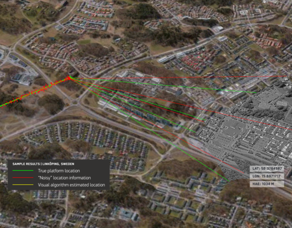
Maxar Intelligence is partnering with Taiwan’s Aerospace Industrial Development Corporation (AIDC) to deploy the Maxar Raptor software suite across Taiwan’s unmanned aerial vehicle (UAV) industry. The move will help the country accelerate the resilience and reliability of autonomous systems in GPS- and GNSS-denied environments.
Raptor is a vision-based software suite that enables autonomous drones to navigate precisely and extract accurate ground coordinates in the absence of GPS. Designed for lightweight integration with any autonomous platform, Raptor products use a drone’s native camera and Maxar’s 100 million-plus sq km of global 3D terrain data to help the platform navigate with extreme precision and extract accurate ground coordinates in real-time without GPS. Raptor can operate at night and in low-altitude flight operations without the need for any additional hardware.
The partnership follows a successful field demonstration of Raptor software in Taiwan earlier this year, in which the test platform was able to maintain precise navigation under GPS-denied conditions using only its native camera and Maxar’s software.
The test platform was able to maintain precise navigation under GPS-denied conditions using only its native camera and Maxar’s software.
“Taiwan is rapidly building one of the most advanced UAV industries in the world, and AIDC is one of the companies leading the charge,” said Anders Linder, general manager, International Government at Maxar Intelligence. “Taiwanese UAV manufacturers are acutely aware of the importance of building resilience against GPS jamming, and AIDC has validated the unique capabilities of our Raptor software. By combining our geospatial intelligence with AIDC’s aerospace expertise, we’ll help Taiwan’s UAV industry maintain its forward momentum, accelerating autonomy across warfighting, humanitarian, and commercial operations.”
AIDC will drive the adoption of Raptor across Taiwan’s UAV supply chain and promote use of the software across the Taiwan Excellence Drone International Business Opportunity Alliance (TEDIBOA), an organization that AIDC chairs.
“This collaboration opens a new chapter for precision vision-based positioning in Taiwan’s UAV sector,” said AIDC President Chin-Ping Tsao. “We will jointly build a Taiwan-focused integration and testing center, highlight GPS-jamming resilience as a core differentiator, and unlock opportunities across Taiwan and the broader Asia market — advancing both defense resilience and commercial value.”
Swift Navigation has partnered with Taiwan Mobile, a major telecommunications company in Taiwan, to introduce the Skylark Precise Positioning Service to the Taiwanese market. This collaboration aims to meet the increasing demand for high-accuracy positioning solutions across various industries.
Skylark is a real-time GNSS correction service that enhances positioning precision to the centimeter level by correcting signal errors from GNSS. It is the first cloud-based precise positioning service developed specifically for large-scale applications, designed to deliver accuracy, reliability, and safety worldwide. The service utilizes advanced atmospheric modeling to reduce errors from ionospheric disturbances, clock drift and satellite orbit inaccuracies, improving location accuracy from several meters to just a few centimeters.
The service is supported by a carrier-grade network consisting of modern ground reference stations, which have been designed and operated collaboratively by Taiwan Mobile and other mobile network operators globally. Skylark’s highly reliable and precise positioning capabilities are expected to support emerging applications in automotive, robotics, and fleet management sectors. In automotive applications, it is the first and only automotive safety integrity level (ASIL) certified, real-time cloud-based positioning service compliant with ISO 26262:2018, enabling safe operation of advanced driver-assistance systems (ADAS) and autonomous vehicles.
For robotics, Skylark’s proprietary atmospheric modeling offers centimeter-level accuracy with extended baselines and automatic failover, ensuring reliable performance for devices such as robotic lawnmowers and surveying drones. In fleet management, the service provides a cost-effective, dependable positioning solution optimized for battery-powered devices, facilitating efficient last-mile and final-inch logistics, and integrating with a broad range of compatible GNSS hardware.
“Seen & Heard” is a monthly feature of GPS World magazine, traveling the world to capture interesting and unusual news stories involving the GNSS/PNT industry.
UK begins UAV deliveries
Image: Screenshot of video by BBC
Royal Mail and UAV company Skyports have launched the Orkney I-Port operation to distribute letters and packages between the Orkney Islands, Scotland, reported the BBC. In partnership with the council’s harbor authority and Scottish airline Loganair, mail will be transported from Royal Mail’s Kirkwall delivery office to the city of Stromness in Orkney. UAVs will then carry items to the islands of Graemsay and Hoy, where postal staff will complete the delivery routes. The UAV service will initially operate for three months and may continue on a permanent basis under existing regulatory frameworks due to Orkney’s unique landscape and the proximity of the islands to one another. The UAV service aims to improve service levels and delivery times to Graemsay and Hoy, as weather and geography typically cause disruption to delivery services. The use of UAVs to deliver mail also may bring significant safety improvements by ensuring that postal workers can deliver between ports without risk.
GNSS is taking a hike, literally
Image: Aleksandar Georgiev/iStock/Getty Images Plus/Getty Images
In July, officials in Taichung City, Taiwan, launched a GNSS-based app to aid lost hikers and to mitigate risk associated with outdoor activities in the area’s mountainous region, reported Tapei Times. The app was developed by the Taichung Fire Bureau in response to a surge in outdoor activities after the COVID-19 pandemic restrictions were lifted and, subsequently, an increase in medical emergencies linked to mountain activities. Wi-Fi towers have been built at major trailheads such as Toukeshan, Anmashan, Fushoushan and Snow Mountain to supplement the app as well as to help facilitate UAV deployment to find lost hikers.
In a biological preserve in Mexico’s Campeche state, a team of archaeologists have documented pyramids, palaces, a ball court and other remains of an ancient city they call Ocomtún, reported The New York Times. Archeologists surveyed the site for six weeks in May and June, finding 50-foot-tall structures resembling pyramids, as well as pottery and Mayan engravings they believe date to between 600 AD and 900 AD. The team determined the city was likely abandoned more than 1,000 years ago. Surveying of the area has been revolutionized over the past decade by lidar — allowing researchers to survey densely forested areas that are difficult to explore on foot. Archeologists were able to use airborne lasers to pierce through dense vegetation and reveal the ancient structures and human-modified landscapes beneath.
More than 350 UAVs were lost during a practice light display show in Melbourne, Australia, on July 14, ahead of a scheduled performance for the opening of the women’s World Cup. The UAVs appeared to stop mid-show and plummet into the Yarra River. Divers have since fished out hundreds of the UAVs. According to the Resilient Navigation and Timing Foundation, the likely cause of the mass-crash was interference with GPS signals.
“Seen & Heard” is a monthly feature of GPS World magazine, traveling the world to capture interesting and unusual news stories involving the GNSS/PNT industry.
Image: BanksPhotos/E+/Getty Images
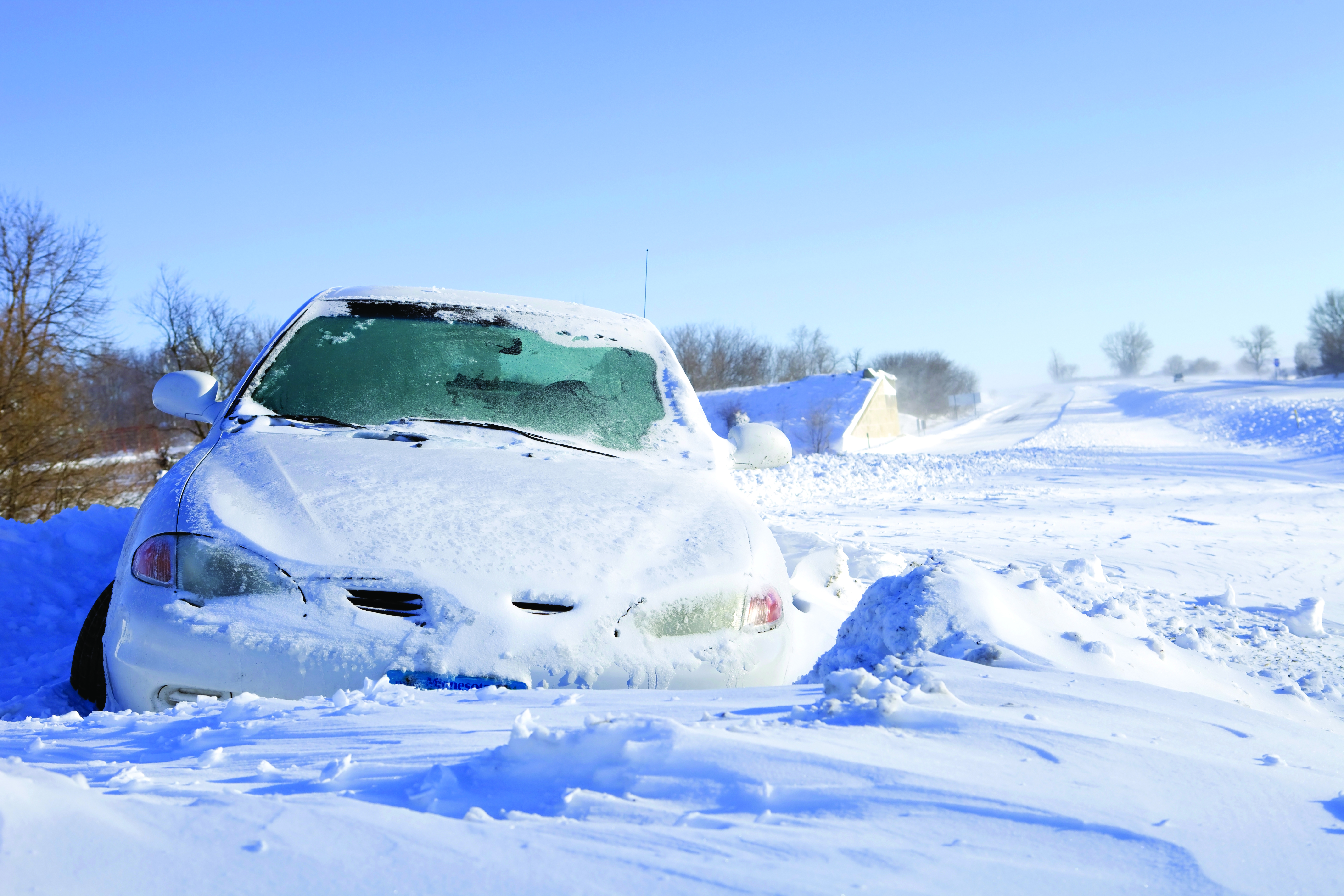
Dozens Stranded in Tundra
Several vehicles in Rock Springs, Wyoming, were stranded after being led by their map apps or vehicle navigation systems to an unmaintained county road in a blizzard. Several calls were made to the Sweetwater County Sheriff’s Office about stranded vehicles stuck after they were directed to the detour when Interstate 80 was closed due to winter conditions. Similar incidents were reported by other counties, resulting in discussions between the Wyoming Department of Transportation and the companies that develop navigation software.
Screenshot: CBS video
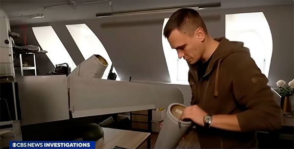
UAVs contain Western Technology
A Ukrainian intelligence assessment obtained by CNN and CBS reported an Iranian UAV downed in Ukraine contained technology from companies in the United States and other western countries. The White House has since launched an investigation as to how the technology — including semiconductors, GPS modules and engines — were obtained by Iran. The components removed from an Iranian Shahed-136 UAV totaled 52, 40 of which were manufactured by 13 different U.S. companies. The remaining components were manufactured by other western companies and by companies based in Japan, Taiwan and China.
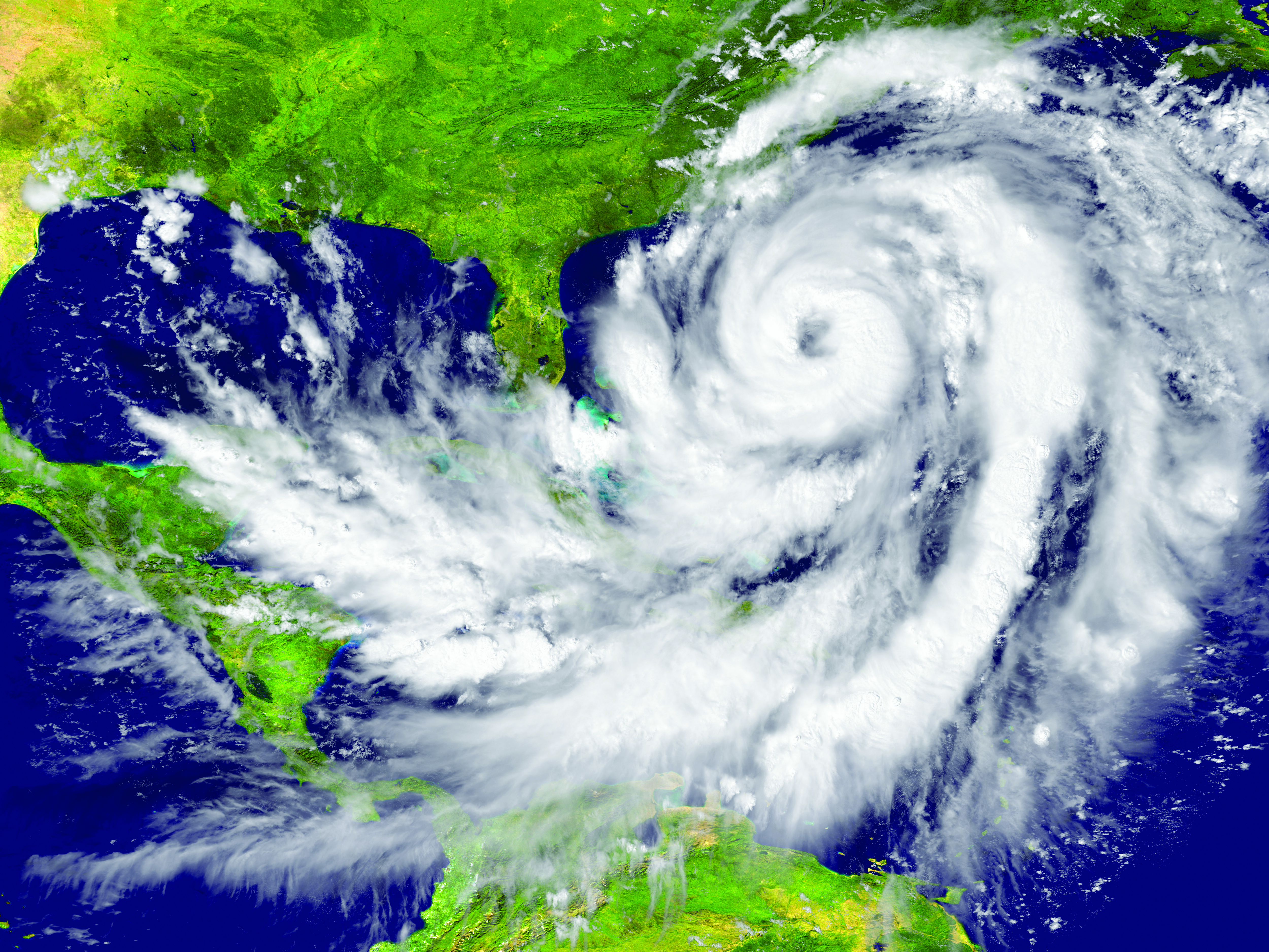
Researchers may now be able to monitor climate-induced natural hazards by combining satellite technology with machine learning. Researchers were able to use machine learning to study hurricanes that made landfall over the Gulf of Mexico in a series of recent experiments. C.K. Shum, the co-author of the study and a professor at the Byrd Polar Research Center, uses geodesy to study global climate change phenomena. Using geodetic data gathered from satellites, Shum tested whether a mix of remote sensing and machine learning analytics could accurately monitor weather phenomena. Accurate measurements could help improve hurricane forecasting.
Sailboat. (Image: valio84sl/iStock / Getty)
The power of TikTok is real
TikTok changed Jeff Foulk’s life when his daughter posted about his free marine navigation app, Argo, when they attended a boat show in Chicago. Foulk was promoting Argo with little success, until his daughter shared with the social media platform his struggle as the owner of a small business. Since then, the app has been downloaded more than 200,000 times and remains at the top of the charts for boat navigation apps. Argo was launched more than four years ago and, until now, had only 100,000 total downloads. Now that Argo is viral, Foulk wants to launch a premium subscription.
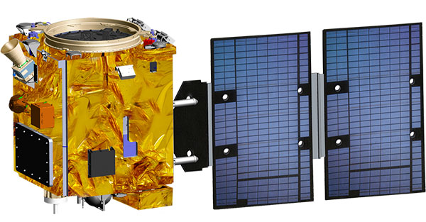
Taiwan will launch its first indigenously developed meteorological satellite in March 2023, reports Taiwan News.
The Triton satellite was designed and made by the National Space Organization (NSPO) over eight years. The satellite has completed testing and is undergoing review.
The 250-kg Triton carries GNSS-reflectometry equipment (GNSS-R) — independently developed by NSPO — to collect GNSS signals reflected by the Earth’s surface. Its mission is to research air-sea interaction to help predict typhoons.
Taiwan is hit by typhoons every year. Information on wave height and sea-surface wind speed, retrieved from the reflected signals, will be useful for research on typhoon intensity and path prediction.
The satellite will be transported to the Guiana Space Center in January. It is scheduled to launch in March aboard a Vega C rocket manufactured by Arianespace.
GPS technology is doing far more than helping us navigate or receive accurate time. It is now being used to fight the spread of the global COVID-19 pandemic.
Global navigation satellite systems are being used to collect big data on travel and contact, but they are also being used in more unconventional ways: for example, quarantine enforcement and sanitation technology.
Read on to learn about a few recent developments in the world of GNSS/GPS that are bolstering the battle against the novel coronavirus.
Electronic monitoring enforces quarantine
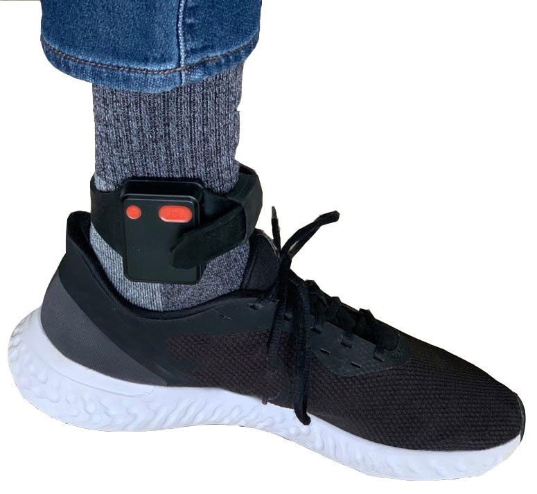
There is a surge of applying ankle monitors to track sick individuals and deter them from spreading the virus further. According to BloombergBusinessweek, one business is thriving because of it: providers of electronic ankle monitors.
Kentucky courts are requiring GPS ankle monitors for people who test positive for COVID-19 and refuse to self-quarantine. Kentucky couple Elizabeth and Isaiah Linscott were two of a growing number of people placed under house arrest after Elizabeth tested positive for COVID-19 and denied signing the Self-isolation and Controlled Movement Agreed Order, a health department document promising she would stay home.
Photo: Regulus Cyber
Elizabeth told Louisville television station WAVE 3 News that she did not sign because she disagreed with the wording of the document. She said that she was concerned about having to contact the health department before traveling, even in the case of an emergency.
“My part was if I have to go to the ER, if I have to go to the hospital, I’m not going to wait to get the approval to go,” she said.
A few days after Elizabeth refused to sign the paperwork, her husband opened their door to an entourage of law enforcement officers serving them with a Health Department order to wear ankle monitors.
“I open up the door, and there’s like eight different people, five different cars, and I’m like ‘what the heck’s going on?’ This guy’s in a suit with a mask. It’s the Health Department guy, and they have three papers for us. For me, her and my daughter,” Isaiah said.
The Linville family is now confined to a 200-foot radius. If they leave their designated quarantine area, their ankle monitors will alert law enforcement.
Alternative to prison
The number of people on house arrest in the United States and across the world has surged as corrections departments struggle to slow the spread of the coronavirus within prisons. An estimated 25 to 30 percent more people are wearing ankle monitors in comparison with a few months ago, according to Bloomberg Businessweek. The U.S. Federal Bureau of Prisons reported a 160 percent increase in home confinement from late March to July. European corrections departments have similarly put thousands of inmates on house arrest in the last few months.
“Demand has spiked everywhere,” BI Inc. monitoring equipment executive Robert Murnock said to Bloomberg. “We’re getting calls from different jurisdictions and other countries we’ve never worked with.”
Efforts to reduce crowding in prisons mean that the electronic monitoring industry is one of very few industries benefiting financially from the coronavirus pandemic.
“Coronavirus gives electronic monitoring companies an opportunity like they’ve never had before to expand,” parole reform expert James Kilgore said.
On Aug. 3, Singapore announced the rollout of electronic tracking devices to enforce quarantine. Travelers will be required to wear GPS and Bluetooth-powered tracking devices that notify authorities if quarantine is broken or the device is tampered with. The rule went into effect on Aug. 11 and applies to all incoming travelers — resident or nonresident — over the age of 12.
On Aug. 20, the premier of Western Australia, Mark McGowan , said his government could soon force people in hotel quarantine to wear electronic monitoring equipment if they are deemed a risk. “If we identify people who are potential flight risks or who might have a criminal history, we are looking at applying monitoring bracelets to them,” he said.
An estimated 25 percent to 30 percent more prisoners are wearing bracelets now compared to the pre-outbreak period. In the U.S., the Federal Bureau of Prisons has placed about 4,600 inmates in home confinement, a 160 percent increase since the end of March.
“Demand has spiked everywhere,” said Robert Murnock, vice president for partnership development at BI Inc., a provider of EM technology.
The emergency shift to electronic monitoring spurred by COVID-19 may foretell a long-term shift toward use as an alternative to prison time, reducing clutter and the risk of the virus spreading among inmates.
Photo: LeoPatrizi/E+/Getty Images
Contact tracing via mobile phones
Israel is using covert mobile phone data to track the spread of COVID-19. On July 1, the Knesset approved a bill temporarily reauthorizing mass surveillance of coronavirus-infected citizens by the Shin Bet, Israel’s internal security service. The original program lasted from mid-March to June 9.
The contact-tracing program works like this. When a patient is diagnosed with COVID-19, the Israeli Health Ministry provides their personal information — including their mobile number — to the Shin Bet. The Shin Bet then consults a classified database of every person who uses Israeli telecom services to determine who came into contact with the infected individual for more than 15 minutes at a time. After the Shin Bet sends information back to the Health Ministry, the Health Ministry notifies those people via text and tells them to self-quarantine.
The Shin Bet’s newfound role in public health enforcement is quite different from its usual focus. Former Shin Bet agents say the COVID-19 mobile phone tracking technology was originally developed as a counterterrorism measure, and the tracking system being used on Israeli civilians is almost identical to that used for suspected terrorists.
“It’s the same system, the same methods,” retired Shin Bet agent Arik Brabbing said to BBC. “We know that someone was here in the park. We can get from the [mobile phone] company all the details about the hour, the place, exactly the place… and we can understand who else was around.”
Supporters of the mass surveillance program, including Prime Minister Benjamin Netanyahu, argue that reduced privacy is necessary to curb the spread of the virus. However, the Israeli government has come under fire by opponents who claim that the program is intrusive and undemocratic.
Israel’s contact tracing procedures are more secretive than those of South Korea and Taiwan, other countries that mandate central mass surveillance. South Korea and Taiwan both enforce quarantines with mobile-phone tracking, and both have built publicly available COVID-19 data platforms.
The South Korean government has disseminated detailed — but anonymized — information about COVID-19 carriers, including their travel routes and treatment facilities. Citizens broadly support these measures — a testament to collectivism in Korean culture.
Civic engagement and enthusiasm for fighting the pandemic is also remarkable in Taiwan, where the public has been collaborating with the government on a town hall-style website called vTaiwan. Citizen-led initiatives, like a GPS-powered tool for tracking face mask supplies, have been applied nationwide.
Meanwhile in Europe, eight major telecom companies, including Vodafone and Orange, have been supplying anonymized metadata to the European Commission to model and predict the spread of the virus. In the United States, the Centers for Disease Control and Prevention is soliciting GPS data from mobile advertising companies rather than carriers themselves.
The two tech giants, Apple and Google, made it easier for health agencies to join its coronavirus exposure notification system, creating a new built-in app within iOS and Android. The app provides real-time notification to users when they are exposed to a sick person.
Virus-killing robots may roam the streets
GPS-based robots, drones and autonomous cars are being deployed to sanitize outdoor spaces, transport medical equipment, and announce safety information to the public.
Robots began rolling around the streets of Wuhan, the original epicenter of the coronavirus outbreak, as early as January. China was the first to deploy robots of this type, but India, Spain, France and other countries have followed in their footsteps. In addition to the chemical-spray approach, some companies are pioneering mobile disinfection robots armed with large ultraviolet-C germicidal lights.
Apollo, the autonomous vehicle company of multinational internet giant Baidu, has partnered with Chinese self-driving startup Neolix to transport food and supplies to Beijing Haidian Hospital. Every morning at 10:30 a.m, an unmanned car delivers meals to about 100 frontline workers. The process eliminates direct contact, protecting the safety of food service workers, hospital staff, and patients.
Zhangjiang Artificial Intelligence Island
A fleet of Apollo and Neolix’s unmanned cars is also responsible for disinfecting all roads on Zhangjiang Artificial Intelligence Island, an 100,000-square-meter industrial complex in Shanghai. The vehicles are loaded with up to 160 liters of spray disinfectant and can cover the island’s entire road system in about half an hour.
The vehicles at Zhangjiang AI double as nighttime surveillance bots. They patrol the island and make sure that guests are adhering to coronavirus protocols, alerting security personnel if they note suspicious activity.
In addition to using drones to spray disinfectant, South Korea’s government has leveraged the technology for public announcements. On July 4, 300 drones lit the sky above Seoul in a show of appreciation for frontline workers. The drones executed a 10-minute synchronized show that included images of face masks, hand washing, and social distancing.
Summary
As COVID-19 continues to ravage the globe, governments rely on GPS to track the virus, contain it, and fight against it. The battle against coronavirus is still being waged on a global scale, utilizing GPS as a weapon along with many other existing technologies.
The pandemic changed the world forever, and it also highlighted the power of tracking and monitoring location of people and machines. It is another testament to the immense reliance on GPS technology in our modern world.
The increased deployment of these technologies necessitates increased security measures, especially when public health is on the line. Regulus Cyber offers GPS Cybersecurity software. To read more about it, visit www.regulus.com.
The COSMIC-1 program ended on May 1, when the last of six tiny satellites were decommissioned. The satellites were launched 14 years ago, and outlived their planned lifespan by 12 years.
COSMIC — the Constellation Observing System for Meteorology, Ionosphere and Climate (COSMIC) mission — uses GPS signals to provide a wealth of accurate atmospheric data and improve weather forecasts, according to Laura Snider, University Corporation for Atmospheric Research (UCAR), which ran the COSMIC program.
Meanwhile, the COSMIC-2 program (FORMOSAT-7 in Taiwan) continues. Its six satellites were launched on June 25, 2019, into low-inclination orbits. The mission was launched by NOAA as the agency’s first operational GNSS radio occultation mission.
COSMIC-1 demonstrated the value of GNSS radio occultation (GNSS-RO) to derive vertical atmospheric profiles of temperature, humidity and pressure by measuring the degree to which GPS signals bend as they travel through Earth’s atmosphere.
Weather centers used the high-quality, accurate data to improve forecasts; the data was also used by researchers.
“Throughout its lifetime, COSMIC-1 made an astounding 7 million vertical atmospheric profiles available to the operational forecast centers and research community,” writes Snider. “These data demonstrably boosted forecast accuracy and were referenced in more than 550 peer-reviewed scientific publications. In all, more than 5,000 users from over 100 countries have accessed COSMIC data.
COSMIC-1 was primarily funded by the National Space Organization in Taiwan, where the mission is called FORMOSAT-3. The leading U.S. sponsor on the project was the National Science Foundation. Other U.S. partners included NASA, the National Oceanic and Atmospheric Administration (NOAA), the Air Force and the Office of Naval Research.
UCAR also led the GPS/MET GPS radio occultation mission in the mid-1990s.
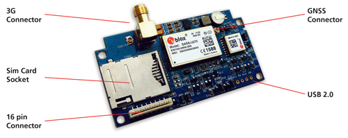
Reyax Technology, a telematics tracking systems provider for the automotive industry, has developed an industrial high-integration 3G GNSS tracking platform, the Reyax RY277AI, which is fully based on technology from u-blox.
“Our vehicle tracking platforms are dependent on highly accurate position data to deliver the performance crucial to meet the demands of our customers. u-blox’s highly reliable products as well as a flawless technical support were convincing,” said Ritchie Chang, general manager of Reyax Technology. “u blox’s MAX M8C positioning module and SARA U270 cellular module were the right choice for this new platform,” he added.
RY277AI is designed for 3G telematics applications, in particular vehicle tracking, fleet management and insurance box. With both MAX-M8C and SARA U270 modules embedded, it also benefits from two of u blox’s GNSS and wireless technology services. With AssistNow, Assisted GNSS (A-GNSS) accelerates the calculation of a position by delivering satellite data to the GNSS receiver via wireless networks or the Internet, also ensuring faster TTFF (time to first fix).
CellLocate, another of u-blox’s trademarked technologies, matches cellular positioning data with previously successful GNSS fixes in shielded environments such as indoors. This is especially useful in case of jammed GNSS signals and in M2M applications. Additionally, u-blox’s nested design enables hosting of next-generation wireless and positioning modules on the same PCB.
“We are excited about this co-operation with Reyax Technology, the recognized leader in telematics tracking systems. Reyax-based solutions make full use of u-blox’s advanced positioning and cellular technologies to enhance vehicle tracking. This solution is an answer to the growing encouragements by the Taiwanese government to promote IoT/M2M applications and whose vision we share.” explained Ming Chiang, country manager of u-blox Taiwan.
RY277AI comes in an LGA package, with a dimension of 70mm x 30mm x 7mm, and an operating temperature of -40~+85° C.
Supergeo Technologies, a global provider of GIS software and solutions, is assisting Kaohsiung City, Taiwan, in analyzing public bike system networks. SuperGIS Desktop 3.2 is helping administrators and citizens conveniently use the public transportation system for bicycles, the company said. Kaohsiung City has decided to provide its citizens with public bikes.
Biking is a popular transportation method and personal leisure activity for the people of Kaohsiung City. Determining where to establish bike stops that will attract locals to use the bikes, without affecting the current busy traffic patterns, is the most important issue for administrators.
The dilemma facing administrators is that bike stops shoud be near facilities, and the distance between each stop shouldn’t be too far. Through GIS technologies, decision makers can easily overlay the different layers that show diverse impact factors, such as nearby subway and train stations, and the most used pick-up and return routes.
Also, SuperGIS Desktop 3.2 provides rich spatial analysis functions. With the buffer analysis, for instance, various factors can be analyzed and displayed so administrators can optimize the vehicle supplement.