Tag: Technical University of Munich

  • Unmanned and AI: Indy Challenge takes autonomous to big track

    Unmanned and AI: Indy Challenge takes autonomous to big track

    When I saw that there was a plan for a whole bunch of unmanned, semi-autonomous racecars to compete at the Indianapolis Motor Speedway (Indy, or IMS) racetrack, I initially thought we might be headed to one significant mess of broken-up machines and potentially a lot of damage. I tracked the various announcements of the competition as things progressed, especially when a prize of $1 million dollars was put up by the Lilly Endowment in Indianapolis, and the majority of the field appeared to be potentially staffed by undergrad university teams.

    Photo: Indy Autonomous Challenge
    Photo: Indy Autonomous Challenge

    However, this isn’t the first time we’ve had unmanned, autonomous road vehicles in competition — we’ve seen highly instrumented SUVs in desert settings in Nevada and California, initially with pretty poor results, which began to improve significantly for the second time round, then vehicles in some simulated street settings with some mixed and also some pretty good results.

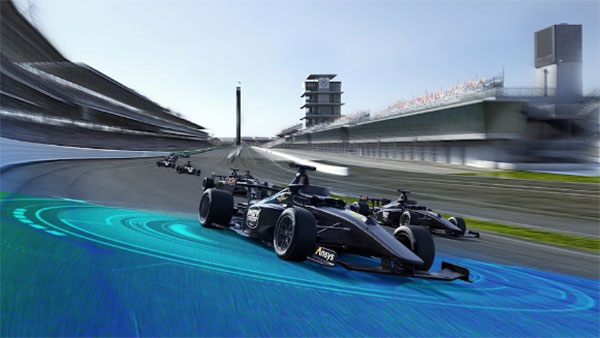
    So, as the competition date grew closer for the Indy Autonomous Challenge (IAC), the number of published progress reports began to increase, and we began to better understand how the initial 40 teams might take on this seemingly impossible task — how on Earth will they replicate a regular Indy (also a class of racecar) race? Surely many unmanned racecars on the same track at the same time doing more than 150 mph would be catastrophic!

    When you take a look, however, at the advances we’ve seen, which have enabled unmanned cars, trucks, taxis and such – surely this tech could stretch to meet these major objectives? But Dallara AV-21 Indy Light racecars avoiding hurtling walls passing by, cornering, getting in and out of the pits, coping with vehicles behind, ahead and overtaking — even a superior-equipped unmanned racecar at >150 mph — well that’s something we would really need to see.

    Then you have to take a look at the outfits involved, providing support to the IAC teams – companies including Cisco, and motor sport units such as ADLINK, Ansys, Aptiv, Bridgestone, Luminar, Microsoft and Valvoline and the non-profit Energy Systems Network. The University teams from around the world themselves appeared to also have significant heritage and skill-levels.

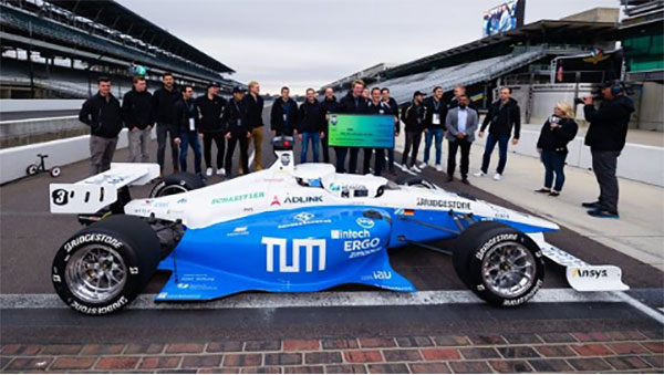
    As the 40 University teams started the long trek to get over the hurdles that this challenge presented, members from 21 of those institutions were actually able to make it to Indy, grouped into nine “national” teams. By October 23 the nine teams, with only one car each, were ready to test their autonomous vehicles on the actual track.

    Clemson University established the baseline Dallara AV-21 vehicle and technology to be used by each team for the race, with sensors monitoring chassis motion, suspension, tires and powertrain. Each team would install its own guidance and avoidance system, with each vehicle equipped with six cameras, four lidars, RTK GNSS, associated radios and bags of computing running each team’s customized control system software. The object being for cars to exit pit-lane, accelerate, brake, establish an optimum line for each corner and flat, avoid obstacles, evaluate the track conditions and establish tolerable limits.

    The teams were required to complete several stages of selection, from submission of initial proposals through demonstration of existing vehicle automation capability, simulated race performance, qualification testing at the Indy track — all leading to an anticipated head-to head race against the other qualifiers.

    Then 20 days of planned testing stretched to 50, and three months of preparation passed with students working intensely throughout, curing the glitches, experimenting with how to increase lap speed, and pushing the limits while still keeping the cars intact.

    Energy Systems Network managed the rules of the final competition in a way that reflected Indy qualification days prior the main race — they judged that the technology was not yet at a stage where multiple cars on the track at the same time would have been such a good idea. So, each car was to individually run a number of practice/qualification laps and the quickest car would be the winner.

    During the first stage of live competition, cars were required to exit the pits and run a warmup lap, followed by two laps that were timed and a slow-down lap that required navigating around inflatable barriers on the front-stretch, and then return successfully back around the track into their pit-stop locations. There were several spins in the corners and several crashes, but the four surviving cars/teams were able to optimistically post speeds of more than 130 mph.

    The winning Technical University of Munich team. (Photo: Indy Autonomous Challenge)
    Photo: Indy Autonomous Challenge

    The final phase involved the four teams taking their cars around a number of warm-up/practice laps, followed by four timed laps. Only the car from Germany’s Technical University of Munich was able to complete all laps with an average speed of ~136 mph, so that team ultimately won the $1 million prize. Even so, all teams were able to successfully mature their systems’ performance through the many months leading up to the IAC and their progress through the various qualification stages. Even the other three final qualifiers had much to celebrate as a result of the competition.

    The sponsors supporting the various teams as they progressed through the Challenge may have spent more than $120 million, so that high-pressure development work will be invested back into many vehicle automation opportunities. After all, that was the main objective for the whole undertaking. We should hopefully begin to see safer, more capable self-driving vehicles emerge in the months to come as the technology is applied to more production vehicle automation.

    Tony Murfin
    GNSS Aerospace

  • A drone can hear the shape of a room

    A drone can hear the shape of a room

    With a speaker and four microphones, drones can echolocate like bats

    Mathematicians at Purdue University in West Lafayette, Indiana, have found that drones can determine position with echolocation.

    The signal-processing research has potential applications for people, underwater vehicles and even cars, said Mireille “Mimi” Boutin, a Purdue University associate professor of mathematics and electrical and computer engineering.

    Boutin and Gregor Kemper, a professor of algorithmic algebra in the Department of Mathematics at the Technical University of Munich, have worked to reconstruct the wall configuration of rooms by using echoes picked up by microphones on the drone.

    Mathematicians found a method to hear the shape of a room using four microphones mounted on a drone. Pictured: Mireille Boutin. (Photo: Purdue University)
    Mathematicians found a method to hear the shape of a room using four microphones mounted on a drone. Pictured: Mireille Boutin. (Photo: Purdue University)

    When a microphone hears an echo, the time difference between the moment the sound was produced and the time it was heard is recorded. That time difference shows the distance traveled by the sound after bouncing on a wall — much like bats use echolocation to orient themselves with their surroundings.

    The challenge is to determine which distance corresponds to which wall, a process called echosorting. Sorting the echoes accurately ensures that all the walls heard are truly there. This way, the algorithm used does not produce “ghost” walls.

    The research is directly related to two complementary problems in engineering: localization (determining where you are in an environment) and mapping (determining the shape of your environment).

    The research, which uses methods from commutative algebra, proves that it’s possible for a minimal setup of four microphones arranged in a non-planar shape, along with a loudspeaker emitting a singal signal, to reconstruct a room.

    The microphones and loudspeaker could be mounted on a moving car, a robot navigating in an indoor environment, or an underwater vehicle exploring a wreck in the ocean. Some of these situations put restrictions on rotations and translations that can be applied to the microphone configuration. The impact of such restrictions on the reconstruction problem will also be studied in future work.

    The next steps will be to consider other scenarios, such as when the movement of the drone is restricted, or when the drone listens to the echoes of consecutive sounds as it is moving.

    Citation.
    “A Drone Can Hear the Shape of a Room,” by Mireille Boutin and Gregor Kemper, SIAM Journal on Applied Algebra and Geometry, 4(1), 123–140, Published online Feb. 6, 2020, https://doi.org/10.1137/19M1248534.

  • Moving mountains: Alps researchers detect a decade of movement

    GPS data serves as the basis for a geodetic model of the Alps. Here, a horizontal strain field is derived from the data. Red areas indicate compression; blue indicates lateral spreading. (Image: DGFI-TUM)
    GPS data serves as the basis for a geodetic model of the Alps. Here, a horizontal strain field is derived from the data. Red areas indicate compression; blue indicates lateral spreading. (Image: DGFI-TUM)

    Our Earth is constantly on the move, as the current Kilauea eruption dramatically illustrates. But capturing data on small shifts over time isn’t so easy.

    A new computer model based on more than a decade of GPS data shows the dynamic movements of the Alps as the mountain range drifts and rises.

    In general, the range drifts an average of one-half millimeter and rises 1.8 millimeters every year.

    However, there are strong regional variances. In South and East Tyrol, a rotation towards the east is superimposed on the overall movement, while at the same time the mountain range is being compressed. And the rise in height is not identical everywhere, either. While very small in the southern part of the western Alps, it reaches its maximum with a speed of more than 2 millimeters per year in the central Alps at the boundaries of Austria, Switzerland and Italy.

    To create the model, researchers at the Technical University of Munich (TUM) German Geodetic Research Institute evaluated measurements made by more than 300 GPS antennas over a period of 12 years, in the German, Austrian, Slovenian, Italian, French and Swiss Alps. Over that time, each of the stations has been making positioning measurements every 15 seconds.

    The team’s model makes the movements visible on a comprehensive basis for the first time.

    The scientists identified the positions of the measurement stations, accurate down to fractions of a millimeter; many of the stations were set up in the EU project ALPS-GPSQUAKENET and are in part operated by TUM.

    Once corrected for snow weight and atmospheric interference, the data show horizontal and vertical shifts as well as lateral spreading and compression at a resolution of 25 kilometers.

    Explains Florian Seitz, chair of Geodetic Geodynamics, “The data are a goldmine for geodesy, with its objective of accurately measuring the surface of the Earth and identifying any changes occurring.”

    Visit https://doi.org/10.5194/essd-2018-19.