The eighth edition of the Geospatial World Forum took place May 23–26 in Rotterdam, The Netherlands, attracting professionals from the surveying and geospatial information system (GIS) sectors. I attended the event on May 24 and took part in a workshop that looked at the benefits of Galileo and EGNOS in geospatial applications in the context of the imminent launch of Galileo initial services.
An industry survey undertaken by the GSA indicates that already more than 80 percent of GNSS receivers for surveying and mapping use are EGNOS-enabled, while 77 percent of geospatial reference network providers have enough information to upgrade Galileo and will be ready to provide a service by 2017. All good news. On the less positive side, more than 60% of professional surveyors did not know about EGNOS!
The workshop also talked up the potential for synergies between Galileo GNSS and Copernicus Earth Observation (EO) systems — a topic of immense interest at the European Space Solutions as well. Hans Dufourmont from the European Environment Agency (EEA) highlighted the use of GNSS to track animal species and monitor migration paths when considering development opportunities. He saw a huge potential for synergies between geopositioning and surface imaging going forward.
Maurice Barbieri, president of the Council of European Geodetic Surveyors (CLGE), also saw a “clear role for Galileo” in the surveying community with its potential ability to meet centimeter accuracy requirements much more than for EGNOS.
He also speculated about the value of establishing a European Geoinformatic Agency that might coordinate the provision of European GNSS and EO data. He felt the private business community would appreciate such simplification.
Reynolds is director of Inta Communication Ltd. and a long-term Brussels observer writing on many aspects of European government policy and implementation for a range of clients and publications. He is the contributing editor for GPS World’s new quarterly e-newsletter, EAGER: the European GNSS and Earth Observation Report.
The annual summit, held in the historic Munich Residenz, is an conference with global impact dealing with satellite navigation. The one-of-a-kind convention of high-ranking worldwide speakers from industry, science and governments provides the participants with a broad overview and different perspectives on the latest developments in the field of GNSS.
Reynold’s session, GNSS and Sciences for Life, will cover maritime search and rescue (SAR), precision agriculture and livestock management, personal fitness and emergency medical attention.
Other sessions include:
GNSS Program Updates — Global systems, chaired by Hank Skalski, Department of Transportation, DOT Liasion to Air Force Space Command, Peterson Air Force Base, USA
GNSS Program Updates — Regional and augmentation Systems, chaired by Dr. Todd Walter, Stanford University, CA, USA
GNSS in the Southern Hemisphere and Equatorial Regions, chaired by Prof. Vidal Ashkenazi, Chief Executive of U.K.-based Nottingham Scientific Ltd, Nottingham, UK
Precise Positioning Technology in Agriculture and Forestry, chaired by Dr. Herbert Landau, Managing Director, Trimble Terrasat GmbH, Hoehenkirchen, Germany
Legal Issues of GNSS Timing, chaired by Dr. Ingo Baumann and Dr. Oliver Heinrich, Partner, BHO Legal, Cologne, Germany
Plus, expect a brand-new conference format for this session:
The GNSS Knowledge Triangle: Tying the Knot Between Education, Research and Industry, chaired by Dr. Fabio Dovis, Associate Professor, Politecnico di Torino, Turin, Italy
The summit is part of the efforts of the Bavarian government and the cluster on aerospace and satellite navigation to stimulate applications and services in this high-tech field.
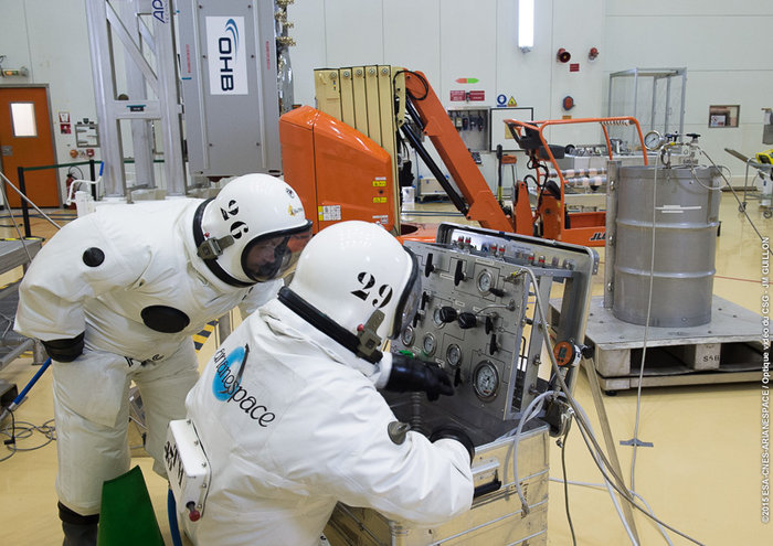
Europe’s ninth and tenth Galileo satellites being fueled by technicians in protective SCAPE suits within the Guiana Space Centre’s 3SB preparation building on Aug. 24. (Photo:ESA)
It has been a good late summer for the European Galileo programme. The latest launch on the night of 10 and 11 September has got the number of orbiting satellites in the EU’s GNSS constellation into double figures at last, and one-third of the way towards the ultimate target of 30.
The European Space Agency’s (ESA) press releases around the launch were positively euphoric, and there were many pictures of smiling ESA launch teams. And so there should be. The two new satellites (the fifth and sixth fully operational capability (FOC) versions named Alba and Oriana) will now inch their way towards their operational orbits and will soon be joined by two more satellites to be launched in December.
However, as we already know, one of the in-orbit validation (IOV) satellites (Sif) is not very well, having suffered a power failure in late May, and the first two FOC satellites (Doresa and Milena) ended up in the wrong orbit. At the considerable expense of a significant part of their fuel payloads, these two craft are now established in a more useful orbit and are the current subject of testing to determine the exact contribution they can make to the Galileo services.
The Commission and ESA are convinced that the outcome will be positive, with Doresa and Milena able to contribute to the network — or at least not degrade the network’s navigation performance. A final decision on if and/or how these two satellites integrate into the system will be made sometime next year.
In any case, they will be used for the provision of Galileo’s Search and Rescue services. And they are also to be made available for scientific research. One possible science area that has been discussed is to ‘repurpose’ the satellites to measure the slow down of time due to the Earth’s gravitational field as predicted by Einstein’s theory of relativity.
However, more worryingly, there are rumours of various glitches and performance issues with other in-orbit members of the constellation. Hopefully, they are just rumours; only time will tell.
Position Paper
Not surprisingly, those wanting to use the system are getting a tad frustrated. On Sept. 1, Galileo Services, a non-profit organisation involving 180 members including most of the active players in the EU GNSS industry, published a position paper entitled “Europe Must Succeed in the Global Navigation Market Race.”
The organisation’s aim is to foster an end-to-end vision of the Galileo system that can fully respond to user and market needs. The paper looks at the options to strengthen the competitiveness of the European GNSS downstream sector in the global market and calls for better coordination between the public and private sectors to develop new technologies, applications, services and industries in Europe as a key factor for success.
In particular, the paper stresses the necessity to urgently establish a European strategic plan to enhance Europe’s GNSS downstream industry’s competitiveness and to foster the uptake of the European GNSS, Galileo and the European Geostationary Navigation Overlay Service (EGNOS), with the aim to corner 33 percent of the global GNSS downstream market for Europe by 2025.
Galileo Services argues that unless an effective and long-term strategy is in place during the Galileo early services exploitation phase — from 2016, the current official start date for services — the window of opportunity for European industry will be closed. Europe’s goal of achieving GNSS autonomy is also at risk. The paper warns that Galileo is just one of three new GNSS solutions, along with the Russian GLONASS and Chinese BeiDou, that are complementing the U.S.’s GPS — and most applications do not require four GNSS constellations.
The target of European autonomy will be achieved if and only if Galileo is widely used with equipment designed and manufactured in Europe, as well as applications and services developed in Europe, concludes the paper.
More R&D Support
Part of the strategy should be enhanced support for EU GNSS technologies and applications. The European GNSS Agency (GSA) has just launched a new research support channel for GNSS chipset and receiver technologies in Europe.
The Fundamental Elements programme has a projected budget of EUR 100 million over the period 2015 to 2020 and is part, says the GSA, of an overall strategy of market uptake initiatives in accordance with EU regulations. “For the first time, EU regulation provides a financing tool for the market uptake of European GNSS chipsets and receivers,” said GSA Executive Director Carlo des Dorides in launching the new programme.
The Fundamental Elements programme complements the EU’s current Horizon 2020 research programme that focuses on adoption of Galileo and EGNOS via content and application development.
Two types of financing will be available via the Fundamental Elements programme: grants and procurement. Grants will be provided to cover up to 70 percent of funding requirements for a project, and intellectual property rights will stay with the beneficiary under the condition that the developed product is actively commercialised.
Procurement (at 100 percent funding) will be used only in cases where keeping intellectual property rights allow for the better fulfilment of the programme’s overall objectives. For example, by licensing it to different potential manufacturers rather than creating a monopoly supplier.
Meanwhile, EGNOS Continues
Of course, one EU GNSS, EGNOS, is operational. The GSA proudly announced that after extensive testing, the latest space segment — the SES-5 GEO satellite — is now fully functional. This will ensure the long-term service of EGNOS until at least 2026 and enable a range of performance improvements, including greater stability during periods of high ionospheric activity.
The SES-5 is a first step in the complete renewal of the EGNOS Space Segment, including the transition to dual-frequency, multi-constellation services. The renewal will be completed by the introduction of the ASTRA-5B signals and the procurement of a new EGNOS payload, both planned for 2016.
In parallel, the GSA and ESA have met formally to launch activities to develop the system further following the signing of a working agreement for EGNOS in July. Under the agreement, ESA will be responsible for the development and procurement of future EGNOS evolutions, such as the forthcoming release (V2.4.2), and a new generation of the EGNOS system (V3).
One of the annual gatherings of the whole European GNSS value chain will take place in October in Berlin with the Satellite Masters conference and awards ceremony. We can be sure that comforting words will be spoken by persons from the Commission, the GSA and ESA about their future plans and present progress. But the real buzz of this event is from the showcase of new ideas and applications for Galileo and EGNOS from pretty much every corner of Europe and beyond.
Despite the uncertainties expressed by some big industrial players, and slow progress in establishing the actual infrastructure, there is still an entrepreneurial enthusiasm from the ‘small guys’ to get involved in this space-based business.
I have attended these events for a few years now. One of the most enthusiastic winners of recent years is JOHAN, a sports application named after renowned Dutch soccer player and now sport commentator Johan Cruyff.
The application is the brainchild of Dutch graduate Jelle Reichert, whom I first met when he won the 2013 European Satellite Navigation Competition with this innovative EGNOS-enhanced tracking idea. “We are now operational with our first four clients! And in a final testing phase we are making the system ready for a commercial launch at the beginning of 2016,” he tells me. “We also just have an investor on board, which allows us to hire personnel and take the final steps to become really commercially ready.”
In just 18 months, Jelle’s idea has been brought into life with support from GSA and ESA. The JOHAN sports tracker and application helps improve teams by monitoring on-field performance. The system’s small, lightweight trackers, or pebbles, use GNSS technology such as EGNOS to ensure reliability and precision.
The trackers are small and light so they can fit into training vests worn by players across a variety of field sports, though early adopters have all been football teams so far. The trackers measure location, speed, distance, acceleration and orientation statistics, which are then visualized in an online data platform for coaches and players. This allows coaches to monitor workload and performance, and get tactical information and event analysis and ensure players’ strengths are used to the whole team’s advantage. Players can spot weaknesses and improve their individual game over time.
“You can see who is training too hard and who has a higher chance of injury, as well as who is strong in which performance aspects, such as endurance, sprint, agility or recovery,” explains Jelle.
I look forward to hearing about lots more grassroots GNSS innovation in Berlin.
And Finally … An Out-of-This-World App?
Take me to the moon! And why not, indeed? It appears that Galileo could be a vital part of an interplanetary navigation system. Or at least it could help (with GPS) spacecraft to routinely navigate to the moon.
A paper in Acta Astronautica highlights the strict requirements in terms of performance, flexibility and cost for all the spacecraft subsystems required to navigate to the moon. GNSS could introduce an easier way to provide an autonomous orbit determination system using an on-board GNSS receiver. While GNSS receivers have already been used successfully to pilot craft in Low Earth Orbit (LEO), their use for very High Earth Orbit (HEO) up to and including the Moon is an active research area.
The study from researchers at the Swiss Federal Institute of Technology in Lausanne (EPFL) made use of the Spirent GSS8000 multi-GNSS constellation simulator, which supports simultaneously the GPS and Galileo systems with L1, L5, E1 and E5 frequency bands. It showed that GNSS signals can be tracked up to the Moon’s surface, but would need new, more sensitive GNSS receiver technology. The paper describes a possible navigation solution that uses a double constellation GPS-Galileo receiver aided by an on-board orbital filter system to improve the accuracy of the navigation solution and achieve the required sensitivity. Without the filter, position error below 700 metres is possible, but the orbital filter increases the position accuracy to within about 100 metres.
Vincenzo Capuano from the EPFL team tells me that a further paper on the use of an GPS L1 C/A based orbital filter for Moon transfer orbits will be published soon, which also shows an achievable accuracy of a few hundred meters. So who needs expensive tracking stations for a flight to the moon?
But the work also has a very practical down-to-Earth application. The EPFL team is developing more sensitive GNSS receivers to pick up these weak signals, and the new receivers could find applications on Earth where current receivers often struggle to get a location, such as inside buildings or in built-up areas, where signals are weak.
EGNOS demonstration equipment aboard an Airbus ATR-42. (Photo by Tim Reynolds)
Toulouse, France, an aerospace city and the center of the French aerospace industry, was the birthplace of EGNOS, Europe’s satellite-based augmentation system (SBAS), in 1994. So it was appropriate that the first-ever EGNOS Flight Event was organized there in May by the European GNSS Agency (GSA) and the European Commission.
EGNOS is the acronym for European Geostationary Navigation Overlay Service. It is also songe — the French word for “dream’”— spelled backwards and, according to Jean-Luc Moudenc, mayor of Toulouse, that is how the name originated.
The dream is now very much a reality. Since its certification for civil aviation in 2011, EGNOS has made steady progress in implementation. Today, 111 airports in 15 countries across Europe benefit from EGNOS, and many more are preparing for implementation — 171 LPV (localizer performance with vertical guidance) and 86 BARO approaches are already certified for use.
The EGNOS Flight Event was organized in collaboration with Airbus and brought together aviation media and other sector stakeholders for a briefing and demonstration of EGNOS, how it works, its benefits for aviation and a glimpse at its future.
The state-of-the-art Airbus A350 WXB is the first wide-body airliner equipped with the SLS. (Photo by Tim Reynolds)
EGNOS for Airbus
It was clear that Airbus sees integration of EGNOS, and SBAS generally, into the avionics of its product offerings, from helicopters to the giant Beluga transport plane, as very much part of the future.
A highlight of the event was a “show and tell” with the Airbus A350 WXB — a real beauty of an airplane. Participants were given a tour of this new state-of-the-art wide-bodied airliner, including a simulation of an EGNOS-enabled LPV landing in the cockpit. Airbus test pilot Jean-Christophe Lair described the A350’s new Satellite-based Landing System (SLS) that works with SBAS such as EGNOS. This is the first time such a system has been installed on a wide-body airliner and will be supplied as a standard feature to all customers.
EGNOS is fully integrated into a common harmonised landing system interface on the A350 — the SLS — that allows the pilot to fly precision approaches like an ILS with geometrical vertical guidance down to 200 feet. This new navigation system will allow Airbus users a wider range of solutions to optimise operations and increase accessibility without any compromise on safety.
“All the systems look the same to the pilot — it is a seamless integration of EGNOS — so no human-factor issues,” said Jean-Christophe. Pilot feedback had been excellent with some 3,000 hours flown on LPV approaches using both EGNOS in Europe and WAAS in North America. “We have experienced no technical or operational issues with SBAS operations,” he claimed. “The SLS shows value every day that it is used.”
SLS/LPV is operationally equivalent to CAT 1 ILS, but brings significant additional assets above the LPV minimum such as the secure coding of the final approach segment and the fact that the SBAS/ LPV vertical profile is geometric and fixed in space. The system can also be useful for creating en-route diversions and allows creation of instrumented approaches. Overall the SLS development on the A350 XWB had been a very positive experience he stated.
Earlier Philippe Rollet, senior expert Air Traffic Management at Airbus, had said that “EGNOS was more important for helicopters than aircraft.” The enhanced EGNOS guidance enabling access to helipads in urban environments. “With EGNOS you can have a helipads everywhere and the system increases operational safety in bad weather,” he claimed. “For Airbus all new helicopter models will be EGNOS capable – it is the baseline for Airbus.”
This enhanced access facility was demonstrated via the GSA-funded GARDEN project that is using EGNOS to enable increased safety and better access for helicopters, for example, enabling air ambulances to more easily access city centre hospitals. EGNOS implementation was demonstrated in the cockpit of an Airbus H175 multi-mission helicopter used as a test-bed for GARDEN.
Technology at Work In Flight. EGNOS was also in action during a series of flights for the media using EGNOS for landing procedures on an ATR turboprop development craft. The plane was equipped with additional avionic displays in the main cabin, and this allowed the press to watch the technology at work without crowding out the pilots on the flight deck! The flight demonstration took off from Blagnac for a 15-minute circuit around the beautiful “pink” city of Toulouse before demonstrating an immaculate EGNOS LPV approach and landing.
Earlier the “press pack” had also been taken on a tour of the massive assembly plant for the Airbus A380 double-decker airliner next to the airport. Well worth a visit if you are ever in the area! In fact, Toulouse is blessed with aerospace tourism attractions such as the City of Space.
Expanding EGNOS?
The media was welcomed to the event by GSA executive director Carlo des Dorides. He emphasised that EGNOS for aviation delivers high precision at low cost. “EGNOS is Europe’s first satellite navigation system — and already has a good success story to tell,” he said. “It helps aviation to be safer, greener and more efficient.” He highlighted EGNOS’s ability to deliver continuous integrity protection in compliance with ICAO standards allowing CAT 1 approaches with more than 99 percent availability.
“Today 142 airports across Europe are benefitting from EGNOS, and the number is growing steadily,” he said. EGNOS’s success in aviation was also helping to spread the word for applications in other transport sectors such as maritime.
With a near-term target of 500 runways to be EGNOS enabled in Europe, the support available for airports and operators wanting to benefit from EGNOS was emphasised by Gian Gherardo Calini, the head of market development at GSA. During 2015 the agency has allotted €6 million to co-fund projects to implement EGNOS in aviation. A similar amount had also been allocated in 2014. GSA provided technical and educational support for implementation as well as financial assistance.
He saw the benefits being increased safety, operational enhancements, plus reduced cost and environmental impact. Widespread implementation would enable new point-to-point commercial airline opportunities.
Key to Significant Growth. EGNOS could be the key to a significant growth in general aviation in Europe. “The need to install ILS made the business case for most general aviation airfield out of the question,” claimed Martin Robinson, senior vice president of the International Council of Aircraft Owner and Pilot Association (IAOPA). There are 4,649 aerodromes in Europe and some 50,000 general aviation aircraft operating from them. In comparison to the situation in the U.S., only a small percentage the aerodromes had been. Of course, the widespread uptake of WAAS in the U.S. is a clear result of a deliberate federal strategy.
“There is definitely room for growth,” said Robinson. “EGNOS will help to provide greater access to aerodromes throughout Europe and to improve safety, but we need to be much quicker if we are to realise these benefits sooner.” He felt every general aviation airfield needed a clear business plan working towards EGNOS ability.
There was some dispute about the exact cost of implementing an EGNOS approach as it varies from location to location, but in broad terms the one-off cost of implementation seems to be equivalent to the annual maintenance cost of on-the-ground ILS equipment. With these economics, wider uptake by regional airports in Europe should be a no-brainer; however, the go or no decision often came down to individuals, said Robinson. He believes European countries need to be more willing to support the European Commission in introducing the technology. Perhaps a more region-led approach is required?
The French government line on EGNOS was given by David Comby of the French Ministry for Ecology, Sustainable Development and Energy, who said France sees EGNOS as essential part of the modernisation process for European airspace making flying safer, more efficient, greener and more cost effective. France was working hard on EGNOS implementation, and it was possible that all French runway ends (~200) would be equipped for EGNOS by 2018.
EGNOS over Africa?
The potential for expansion of EGNOS / SBAS across the globe is huge. Despite having to battle against a barrage of taxiing aircraft noise, Jean-Marc Piéplu Head of EGNOS Exploitation at GSA described the upgrade path for EGNOS from the current Version 2 to EGNOS V3. “Version three will feature new capabilities,” he said. “Dual-frequency and dual-constellation with both GPS and Galileo signals available.”
In theory EGNOS V3 could provide EGNOS / SBAS coverage for aviation to more than 90 percent of the global land surface. Piéplu indicated that if the political will was there to implement, then this extension of coverage could be accomplished in 10 years. There were no outstanding technical issues. He also said that there were no current plans to use GLONASS signals with EGNOS.
A key market could be Africa. Establishment of transport infrastructure is seen as a key enabler for sustainable development in the less-developed world, and SBAS-based infrastructure could provide a cost-effective solution to boost connectivity safely without having to invest in vulnerable ground-based equipment.
Julien Lapie from the Agency for Air Navigation Safety in Africa and Madagascar (ASECNA) highlighted that over 40% of citizens in Africa were more than 250 miles from an ILS-equipped airport. Negotiations on use of EGNOS over Africa are ongoing, but could be completed as soon as 2016.
As the not-so-subtle EGNOS advertising tag goes: It’s there. Use it.