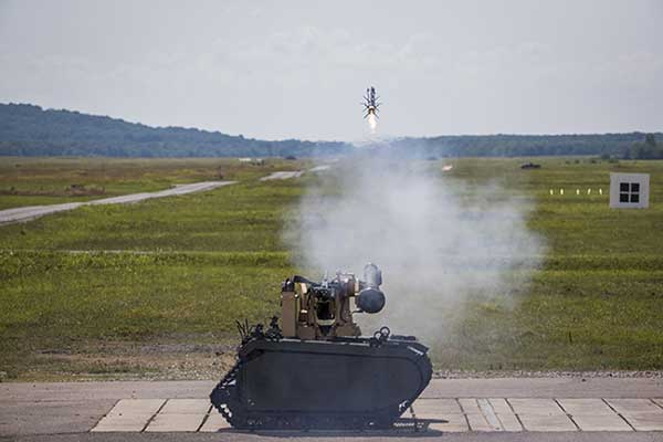
Remotely controlled Javelin firings can help keep soldiers out of harm’s way. (Photo: Lockheed Martin)
The Javelin Joint Venture team, a partnership of Raytheon Company and Lockheed Martin, successfully fired Javelin missiles from a Kongsberg remote launcher mounted on a Titan unmanned ground vehicle built by QinetiQ North America and Milrem Robotics.
The demonstrations, conducted at the U.S. Army Redstone Test Center, Alabama, validated the integration of the weapon station, missile and vehicle.
“Javelin is ready to support emerging military robotic vehicle requirements,” said Sam Deneke, Raytheon Land Warfare Systems vice president. “Remotely operated technology like this protects soldiers in battle.”
Javelin has been fielded on the Common Remote Operations Weapon Station-Javelin across U.S. Army Stryker 8×8 vehicle brigades in Europe.
“Javelin offers true fire-and-forget engagements to 4 kilometers in most operational conditions,” said David Pantano, Javelin Joint Venture vice president and Lockheed Martin Javelin program director. “Once the launch command is issued, soldiers and vehicle assets like the UGV can reposition out of harm’s way. These tests demonstrated our ability to evolve Javelin capabilities to address new missions in support of the warfighter.”
Javelin is a versatile one-man-portable and platform-employed anti-tank and multi-target precision weapon system. The Javelin Joint Venture team has produced more than 45,000 Javelin missiles and 12,000 command launch units. The program continually updates the system to stay ahead of advancing threats, including enhancing its platform-mounted capabilities.
U.S. and coalition forces have used Javelin extensively in Afghanistan and Iraq in more than 5,000 engagements.
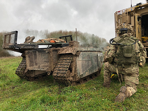
In December 2018 near Salisbury, England, four Milrem Robotics’ and QinetiQ TITAN unmanned ground vehicles (UGVs) were put through three weeks of rigorous tests by British troops during the Army Warfighting Experiment 2018 (AWE18).
The goal was to determine how new unmanned technologies can enhance soldier’s survivability and effectiveness on the modern battlefield.
The modular base can be adapted for various missions, including casualty retrieval. (Photo: Milrem Robotics)
The test was conducted in three phases: conduct combat operations without the benefit of new technologies; conduct combat operations using new technologies but without changing tactics; and, lastly, conduct combat operations using new technologies and adapting tactics according to the capability that the new technology provides.
The UGVs were used in a number of different roles with missions conducted in urban, open and forested terrain.
In remote-control mode, a command-and-control station allows the operator to receive real-time sensor data from the UGV and to transmit command data to the vehicle through a tactical data link. Various third-party sensor packages can be installed.
Of the four Milrem UGVs, two were deployed by Milrem Robotics and two by QinetiQ. The Milrem-fielded systems included one configured as a casualty evacuation and logistical support unit and a second unit equipped with a tethered multi-rotor drone pod provided by Threod Systems.
One of the four UGVs was TITAN Strike, a prototype system carrying a Kongsberg remote weapon station, fully controlled by a remote operator and using QinetiQ’s Pointer system as a means of integrating the capability with dismounted infantry.
The second system, TITAN Sentry, also enabled with Pointer, featured a Hensoldt-provided sensor suite including electro-optical and thermal-imaging cameras and a battlefield radar.
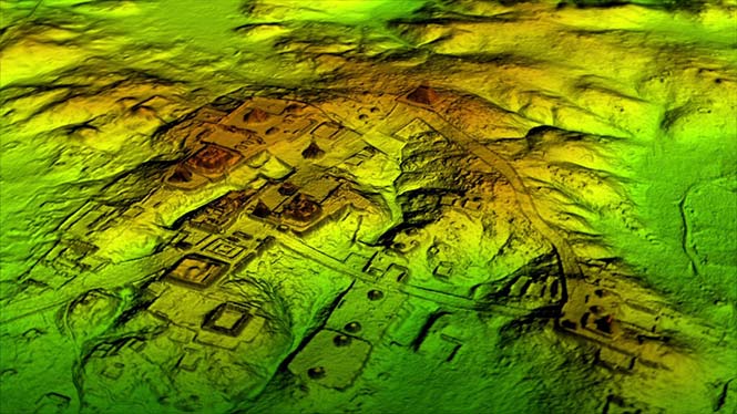
Lidar and UAV technology has revealed hundreds of previously unknown Mayan ruins in the Guatemalan rainforest.
The Optech Titan stripped away overlying vegetation to reveal extensive Mayan ruins in Guatemala’s rainforest. (Image: Teledyne Optech)
In what is considered biggest aerial lidar survey in the history of archaeology, a vast and complex civilization has been discovered.
The University of Houston’s National Center for Airborne Laser Mapping (NCALM) used Teledyne Optech’s Titan sensor to identify raised highways, and complex irrigation and terracing systems.
The jungle of Central America is one of the last great frontiers of archaeology, according to National Geographic, which covered the new finds in a recent documentary, Lost Treasures of The Maya Snake Kings.
After the collapse of the Mayan civilization, its cities and monuments were quickly covered by thick rainforest, hiding it from airborne observation and making it very difficult to survey on foot. Over decades of work, the ancient civilization has gradually been revealed. But now technology is set to change everything.
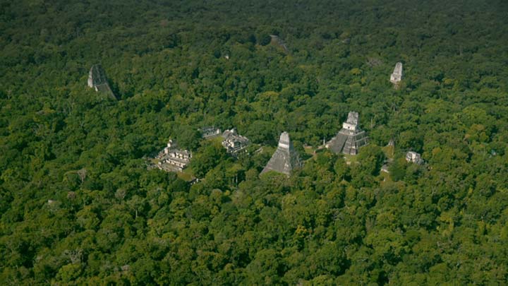
Lidar digitally removes the forest canopy to reveal ancient ruins below, showing that Maya cities such as Tikal were much larger than ground-based research had suggested. (Photo: National Geographic)
Flying high above the rainforest, the Titan’s lasers penetrated the canopy to collect almost a million data points per second from the forest floor, giving archaeologists a “bare earth” view of the structures underneath.
Having covered 2,100 square kilometers, the Titan’s data revealed massive amounts of ruins hidden below the forest, showing that their urban centers were significantly larger than archaeologists had previously thought.
“Lidar is revolutionising archaeology the way the Hubble Space Telescope revolutionised astronomy,” Francisco Estrada-Belli, a Tulane University archaeologist, told National Geographic. “We’ll need 100 years to go through all [the data] and really understand what we’re seeing.”
(Image: Teledyne Optech)
“We are incredibly proud and excited that our award winning Titan multispectral lidar sensor has contributed to this spectacular discovery,” said Michel Stanier, EVP and general manager of Teledyne Optech. “The Titan’s ability to strip away overlying vegetation and map wide areas very quickly and accurately makes it an important tool for archaeologists, and we expect to see many more discoveries coming from it and our other airborne laser terrain mappers.”
The Optech Titan multi-spectral lidar sensor incorporates three independent laser wavelengths into a single sensor design, with beams at 532, 1064 and 1550 nanometers (0.5/1.0/1.5 microns) and a ground sampling rate of 300 kHz per beam.
Because Titan uses both green and infrared channels, it is capable of simultaneous water-depth mapping and high-precision 900-kHz topography.
Titan can also be used for purposes such as vegetative and forestry applications, which require multiple wavelengths for improved classification accuracy and carbon credit counting initiatives.
Lidar and UAV technology has revealed hundreds of previously unknown Mayan ruins in the Guatemalan rainforest.
The Optech Titan stripped away overlying vegetation to reveal extensive Mayan ruins in Guatemala’s rainforest. (Image: Teledyne Optech)
In what is considered biggest aerial lidar survey in the history of archaeology, a vast and complex civilization has been discovered.
The University of Houston’s National Center for Airborne Laser Mapping (NCALM) used Teledyne Optech’s Titan sensor to identify raised highways, and complex irrigation and terracing systems.
The jungle of Central America is one of the last great frontiers of archaeology, according to National Geographic, which covered the new finds in a recent documentary, Lost Treasures of The Maya Snake Kings.
After the collapse of the Mayan civilization, its cities and monuments were quickly covered by thick rainforest, hiding it from airborne observation and making it very difficult to survey on foot. Over decades of work, the ancient civilization has gradually been revealed. But now technology is set to change everything.
Lidar digitally removes the forest canopy to reveal ancient ruins below, showing that Maya cities such as Tikal were much larger than ground-based research had suggested. (Photo: National Geographic)
Flying high above the rainforest, the Titan’s lasers penetrated the canopy to collect almost a million data points per second from the forest floor, giving archaeologists a “bare earth” view of the structures underneath.
Having covered 2,100 square kilometers, the Titan’s data revealed massive amounts of ruins hidden below the forest, showing that their urban centers were significantly larger than archaeologists had previously thought.
“Lidar is revolutionising archaeology the way the Hubble Space Telescope revolutionised astronomy,” Francisco Estrada-Belli, a Tulane University archaeologist, told National Geographic. “We’ll need 100 years to go through all [the data] and really understand what we’re seeing.”
(Image: Teledyne Optech)
“We are incredibly proud and excited that our award winning Titan multispectral lidar sensor has contributed to this spectacular discovery,” said Michel Stanier, EVP and general manager of Teledyne Optech. “The Titan’s ability to strip away overlying vegetation and map wide areas very quickly and accurately makes it an important tool for archaeologists, and we expect to see many more discoveries coming from it and our other airborne laser terrain mappers.”
The Optech Titan multi-spectral lidar sensor incorporates three independent laser wavelengths into a single sensor design, with beams at 532, 1064 and 1550 nanometers (0.5/1.0/1.5 microns) and a ground sampling rate of 300 kHz per beam.
Image: Teledyne Optech
Because Titan uses both green and infrared channels, it is capable of simultaneous water-depth mapping and high-precision 900-kHz topography.
Titan can also be used for purposes such as vegetative and forestry applications, which require multiple wavelengths for improved classification accuracy and carbon credit counting initiatives.
IFEN GmbH’s Titan GNSS simulator has up to 256 channels (and 1024 multipath channels) and up to 4 RF outputs per chassis, providing flexibility and outstanding performance, according to IFEN.
The extra complexity and cost of using multiple signal generators is avoided, improving reliability without compromising on functionality, IFEN said in a news release.
The innovative design of the NCS Titan allows users configure channels for any GNSS signals and allocate those channels to any of the RF outputs fitted. This flexibility enables the same simulator hardware to be used for an extensive range of tests, for all types of GNSS applications.
The NCS Titan GNSS simulator by IFEN.
The NCS Titan sets new standards in the field of GNSS Simulation, in terms of fidelity, accuracy, dynamics, iteration rates and reliability, the company said.
“The launch of our brand new NCS Titan GNSS Simulator represents another milestone for our NCS GNSS simulator products,” explained Günter Heinrichs, head of customer applications at IFEN. “This shows clearly once again our commitment to ongoing product enhancement and dedication to providing our customers with best GNSS test equipment on the market.”
The NCS TITAN GNSS Simulator has been developed in cooperation with WORK Microwave GmbH, Germany.
About 10 years ago PBS aired a very funny science fiction comedy called The Hitchhiker’s Guide to the Galaxy, written by Douglas Adams. The serial radio programs, which originated in Great Britain, were about two characters who traveled the universe by bumming rides on spacecraft. One curiosity highlighted in the second episode was the Tower of Babel-inspired “Babel fish,” which was described as (spoken with an authoritative British accent):
Small, yellow, and leech-like, and probably the oddest thing in the Universe. It feeds on brainwave energy received not from its own carrier but from those around it. It absorbs all unconscious mental frequencies from this brainwave energy to nourish itself with. It then excretes into the mind of its carrier a telepathic matrix formed by combining the conscious thought frequencies with nerve signals picked up from the speech centers of the brain which has supplied them. The practical upshot of all this is that if you stick a Babel fish in your ear you can instantly understand anything said to you in any form of language.
We’ve all been looking for a Babel fish for geospatial data. In the early years of GIS, sharing data was very painful. The most glaring difficulty was the issue of projections. You had to know the datum and projection the data were created in and modify it — or your GIS environment — to match. More recently, thanks to that uncomfortable word “metadata” and more advanced GIS software such as ArcGIS, users were able to import GIS data and re-project it on the fly.
This was a much easier method, but still messy on occasion. ArcGIS opened the door to importing and sharing spatial data across networks, and even the Web. You could actually create GIS projects that accessed data layers from remote servers and sources, ensuring that you had the latest version every time you opened a project. But this was still an environment for GIS professionals and not easy to do.
Recently, Google Earth changed the picture by creating a very easy-to-use spatial viewing environment. This really opened the eyes of the world and introduced non-GIS people to the world of spatial data. The Google environment was simple to understand, but somewhat limited to viewing spatial data and imagery with no real spatial analysis capability. It was especially good at organizing spatial data for visualization.
ESRI soon followed, offering a more robust viewer that could be best described as a professional version of Google Earth with spatial analysis capability. However, one still had to suffer through the zoom-in globe. As good as life became with both Google Earth and ArcExplorer, there was still room for improvement. Then, several months ago, I saw a demonstration of ERDAS TITAN (formerly known as Leica TITAN).
TITAN takes spatial data sharing, viewing, and publishing to a new level. It seems to magically ingest almost any spatial data format, read it, use it, and publish it back out in any format — and do so quickly. It does for spatial data what the Babel fish did for language and speech. A universal translator designed for sharing and the sharing environment is completely controllable via permissions, so you don’t lose data ownership. TITAN delivers data via geospatial Web services, such as Web Map Services (WMS), permitting you to view spatial data without actually getting access to the source dataset.
Most early adopters seem to be data providers and emergency response organizations, because this new globe solves their most critical problem: publishing data with permissions while retaining digital ownership rights (data providers) and ingesting, organizing, and using spatial data from many disparate sources very quickly (emergency management). With TITAN, emergency management organizations and workers have ready access to real-time data appropriate for situational awareness and response management. Communication using chat and collaboration via 3D interactive presentations is easily implemented for disaster participants. Key decision-makers have access to the same common operational picture with up-to-date information.
The datasets are searchable, accessible, and viewable by a broad spectrum of disaster workers using a broad array of applications. Data creators can publish geo-products with permissions from the field for direct and rapid delivery without format translation problems. Licensed data is controlled with participants accessing current content as well as historic and pre-disaster data.
A screenshot of the TITAN environment, showing the Geospatial Instant Messenger chat window. Image courtesy of ERDAS.
Amy Zeller of ERDAS shared some of the features and applications of TITAN, specifically:
TITAN is a scalable, dynamic, rapidly deployable, online, real-time data sharing solution, supporting data publishing and delivery into many geospatial applications.
TITAN enables “real-time” shared viewing of a common operating picture vital to effective communication during an emergency response.
Users can create and share a “MyWorld,” a geographically enabled space to upload data, set permissions, and share content with other network users. This “geospatial presentation space” means sharing crucial geospatial data, notations, images, and other location-based content in a collaborative, interactive 3D space with thousands of users across the globe. This feature, plus instant messenger chat, enables real-time, effective communication and collaboration among disaster participants within a common operational picture.
By using TITAN, authors of data become servers of data, publishing geo-products immediately with permissions and from the field.
Data publishing is facilitated while digital ownership rights are protected. TITAN enables ingestion of data in various file formats and delivers data via different means, including geospatial Web services (e.g., WMS), which means that only a portrayal of the data is distributed and the data owner still has full control over the actual dataset.
Data consumers can rapidly pull data from unlimited public and private sources, directly into a variety of applications including Google Earth, Microsoft Virtual Earth, ERDAS IMAGINE, ArcMap, ArcGIS Explorer, MapInfo, GeoMedia, and AutoCad.
TITAN is interoperable and can be used in conjunction with static, centralized data stores and solutions — but it does not need to rely only on static, centralized data stores!
A TITAN GeoHub enables internal and external permission-based data distribution for disaster management. With a GeoHub, stakeholders can rapidly be enabled to participate in publishing and consuming data. A GeoHub is ideal for implementation at a local government operations center or state EOC, yet flexible and sturdy enough to be set up and configured quickly and run from a field office.
The TITAN solution is a scalable solution and provides support for large numbers of users over a broad geography.
Users can connect to ERDAS TITAN via a cell phone, aircard, and laptop.
You may remember that my February article was about Virtual Alabama, which is a Google-based state emergency response spatial visual collaboration environment. Virtual Alabama has received national interest, and the evolution of VA will be a plenary session topic at the DOJ, DHS, and DOD-sponsored Critical Incident Preparedness Conference in October. Virtual Alabama was the first application that came to mind when I saw the potential of TITAN. In addition to enabling access to current, rapidly developing content in disaster situations, TITAN ties into historic and pre-disaster data and content that is already made available via various data management and delivery solutions.
This entire data sharing and delivery environment is very complex, with connectivity issues, security concerns, and nuances of performance. I know that there are many software products and custom applications that accomplish what TITAN does, but I haven’t seen an off-the-shelf product that matches TITAN’s capability. Let me know if you have seen one, so I can share it with our readers. In the meantime, TITAN deserves a serious look.