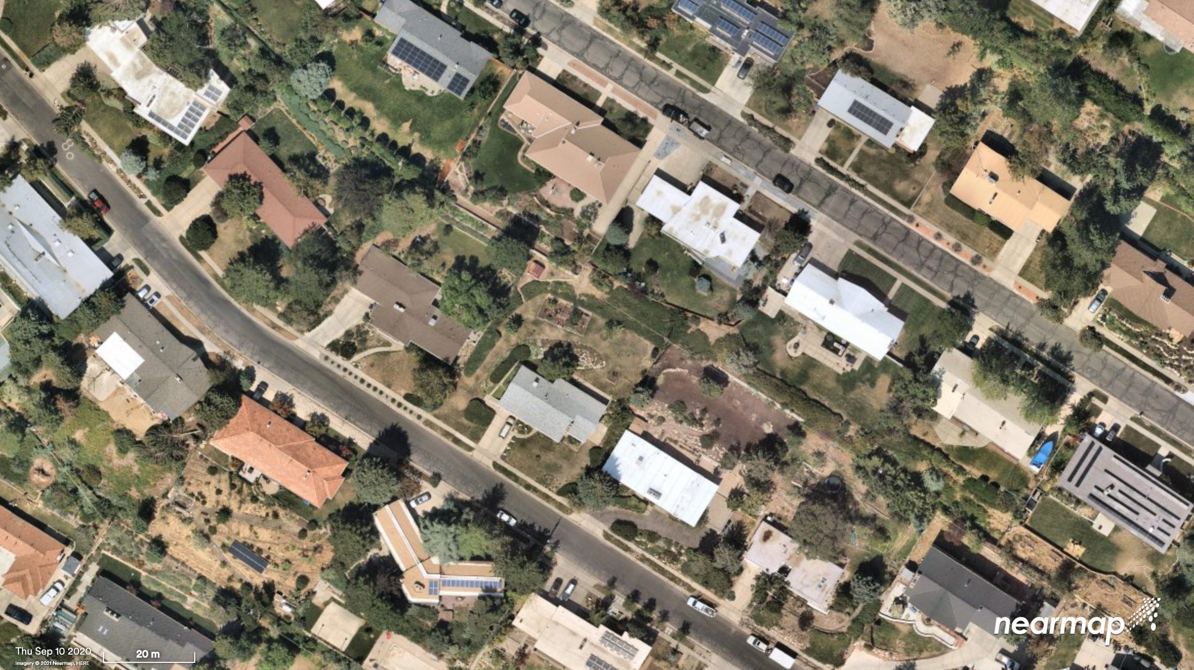
Nearmap will capture aerial imagery of more than 80% of the U.S. population up to three times a year, enabling clients to access 130,000 square miles of additional content, including double the urban coverage of oblique/3D content
Aerial imagery and location intelligence company Nearmap has expanded its United States coverage program to more than 80% of the country’s population. This massive boost in coverage provides companies that rely on high-resolution aerial imagery with improved decision-making capabilities that will help them save time, effort and money, Nearmap stated in a press release.
“Nearmap customers have asked us to increase the amount of the U.S. that we cover and we’re responding by doubling down on our coverage,” Tony Agresta, general manager of North America, Nearmap said. “Our clients will have access to 130,000 square miles of additional unique captured footprint in the United States.”
Overall, the Nearmap capture program will cover more than 1,740 urban areas within the United States, including more than 80% of the population with 308,000 unique square miles captured annually.
In capturing aerial imagery, Nearmap focuses on currency, consistency, coverage and ease of access. The imagery is published within days of capture, with 24/7 access through a web app, API or third-party integration.
“Around 11,300 customers worldwide rely on Nearmap to be their eye in the sky, and to provide them with the truth on the ground,” Agresta said. “We’re seeing strong momentum with new and existing customers in the United States. This massive boost in coverage reflects the broader investment and focus Nearmap has on the strategically important U.S. market.”
Features of the expanded mapping coverage include:
130,000 square miles of additional unique captured footprint in the United States, equivalent to about 63,000 football fields
double the number of urban areas covered with oblique/3D content
access to current content, with updates up to three times a year, including leaf-off and leaf-on collection
images at a high resolution, ranging from 2.2 to 3 inches.
Across the world, Nearmap will also capture more than 64% of the population in Canada; more than 90% of the population in Australia, and about 73% of the population in New Zealand.
“The expanded aerial coverage complements our city-scale 3D content, artificial intelligence (AI) data sets, and geospatial tools,“ Agresta said. “Nearmap has also recently tested in flight the next generation of our patented aerial camera system, HyperCamera3, to ensure our clients are supported by the very best technology in the market.”
What improvements will GPS III bring to high -precision surveying? When? Will these improvements require any changes in equipment and/or processes?
Tony Agresta, Nearmap
“The biggest impact of GPS III to high precision surveying will be a full constellation of L5 satellites. Triple frequency will bring faster convergence times and better accuracy in more difficult conditions. GPS III will better align with Galileo and BeiDou with L1C which means better availability in restricted sky conditions. Users will want to have equipment capable of supporting these new signals, in antenna and receiver HW as well as the signal processing done on board.” Tony Agresta
Nearmap
Jean-Marie Sleewaegen
“Of all the improvements brought by GPS III, the new L1C signal will probably have the biggest impact on high-precision surveying. Compared to L1 C/A, L1C brings better reception in difficult environments, improved availability thanks to the “pilot” component, enhanced resilience to jamming attacks, and better interoperability with Galileo, BeiDou and QZSS. Many receivers do support L1C already, but the benefits will become more tangible as the GPS III constellation grows.” Jean-Marie Sleewaegen
Septentrio
Members of the EAB
Tony Agresta Nearmap
Miguel Amor Hexagon Positioning Intelligence
Thibault Bonnevie SBG Systems
Alison Brown NAVSYS Corporation
Ismael Colomina GeoNumerics
Clem Driscoll C.J. Driscoll & Associates
John Fischer Orolia
Ellen Hall Spirent Federal Systems
Jules McNeff Overlook Systems Technologies, Inc.
Terry Moore University of Nottingham
Bradford W. Parkinson Stanford Center for Position, Navigation and Time
How have improvements in mapping data-collection advanced other PNT technologies?
Tony Agresta
“Real-time positioning, navigation and timing (PNT) benefit from high-resolution aerial maps captured and published on a consistent basis. With sub 3-inch aerial photographs streamed through custom applications or instantly accessible solutions, governments and commercial use cases apply these maps for emergency 9-1-1 dispatch, routing guidance, and new information applications to inform citizens.” Tony Agresta
Nearmap
Ismael Colomina
“In principle, PNT shall be based on linear/angular motion sensors. However, since the origins of aerial triangulation down to contemporaneous hybrid multi-sensor systems, mapping and motion sensors have cooperated in PNT tasks. Current visual- and lidar-odometry are brilliant examples thereof.” Ismael Colomina
GeoNumerics
Members of the EAB
Tony Agresta Nearmap
Miguel Amor Hexagon Positioning Intelligence
Thibault Bonnevie SBG Systems
Alison Brown NAVSYS Corporation
Ismael Colomina GeoNumerics
Clem Driscoll C.J. Driscoll & Associates
John Fischer Orolia
Ellen Hall Spirent Federal Systems
Jules McNeff Overlook Systems Technologies, Inc.
Terry Moore University of Nottingham
Bradford W. Parkinson Stanford Center for Position, Navigation and Time
At the 2019 Esri User Conference in San Diego, Nearmap’s Tony Agresta discusses Nearmap 3D, which allows customers to stream and export 3D imagery on demand at massive scale, through its proprietary MapBrowser web application.
Aerial imagery business Nearmap has launched its new 3D product to streamline the way industries such as urban planning, architecture, construction, government and councils view and shape cities across Australia and the U.S.
The company is also previewing its groundbreaking artificial intelligence (AI) technology at its customer event Navig8.
Nearmap 3D allows customers to stream and export 3D imagery on demand at massive scale through its proprietary MapBrowser web application. Because the imagery is updated frequently, businesses can work with the most current information to make more informed decisions.
Nearmap’s new AI technology is turning millions of aerial images — captured over a decade and multiple times a year — into valuable datasets. The datasets can be used to more accurately and efficiently measure change and quantify attributes, such as solar panels, pools, roofs or construction sites.
Organizations ranging from small businesses to large companies and cities will be able to take advantage of AI-driven location intelligence.
“Product innovation is in our DNA. Everything we do has the customer at the core,” said Tony Agresta, executive vice president of product at Nearmap. “Our customers’ worlds are evolving every day. We need to keep innovating to continue to give our customers a competitive advantage through technology breakthroughs like the ones we are sharing today at Navig8.
“Nearmap 3D is the result of a significant investment in R&D, but also listening to our customers and what they need to transform the way they work,” Agresta said. “Accessing 3D imagery up to now has typically been an arduous, time-consuming and expensive process — but not anymore. This represents the single largest, most frequently updated footprint of 3D accessible through a browser. The ability to measure in 3D space, size up an area and then export Nearmap 3D for use in other platforms will transform the aerial imagery market.
“The AI technology that we’re working on will allow organizations to identify locations with specific attributes and in so doing, reduce site visits, generate more leads, and eliminate the time involved to inspect properties manually. Nearmap AI does the heavy lifting so you don’t have to,” Agresta said.
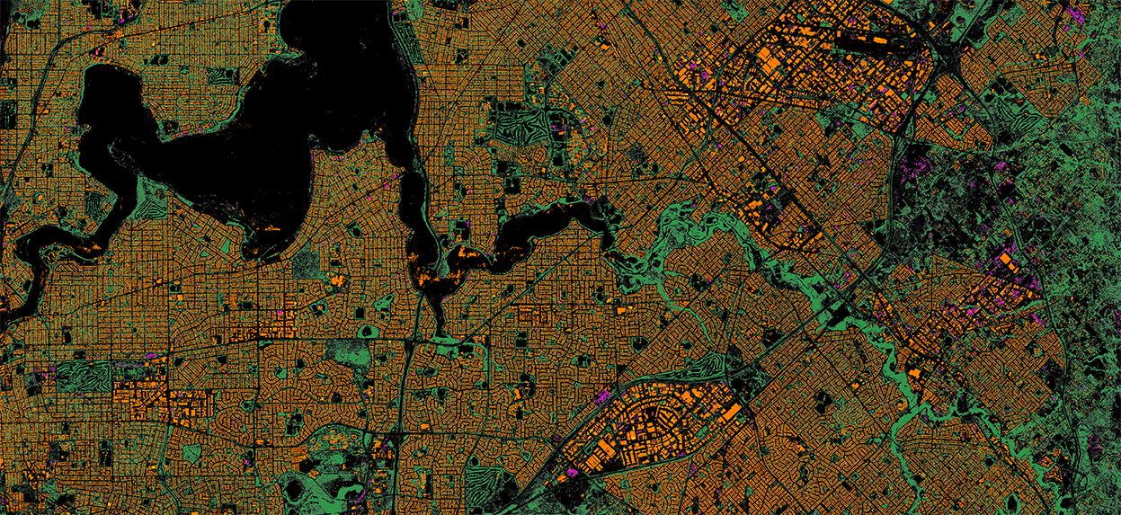
Composite aerial image of Perth, Australia. (Image: Nearmap)
Instant access to 3D through MapBrowser
Nearmap is making 3D imagery accessible to anyone, in the same way it has with 2-D. While Nearmap has offered 3D imagery since 2017, this new iteration of the technology allows users to instantly stream 3D content at massive scale via its MapBrowser web application.
The lightweight platform offers customers an immersive 3D experience, allowing them to visualize cities in 3D from any direction, measure distances, and immediately export a custom area in a variety of 3D formats at unprecedented speed — the download time is a matter of minutes for most requirements and only a few hours for very large footprints.
“It’s like switching from DVDs to streaming services,” said Tom Celinski, executive vice president of technology and engineering at Nearmap. “Our camera technologies have been capturing 3D since 2017, but now our secret sauce is bringing it onto MapBrowser, allowing users to easily and instantly stream this content with many export options. Now users can visualize, measure, define a custom area, export our 3D and use it in their workflows with other commercial platforms and tools. We’re helping 3D experts and novices alike access reality like never before, and this is an important next step in our Reality as a Service journey.”
Nearmap 3D comes with an extensive library, covering more than 400,000 square kilometers. It is updated once a year and covers major urban areas in Australia and the U.S.
“We live in a 3D world, we think in 3D, and so we have to ensure that our products give the closest representation of reality as possible,” Celinski said. “That means businesses that rely on visualizing 3D content, like architects, for example, can now access up-to-date 3D models instantly and export them in just minutes. In a tender process, for example, that can be the difference between winning a new project or not. The opportunities for Nearmap 3D are endless.”
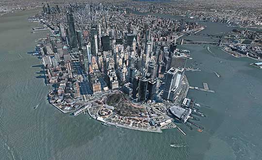
3D image of Manhattan. (Photo: Nearmap)
A living data set
Nearmap AI technology is the result of more than two years’ worth of research and development, and a team of close to 20 data scientists and machine learning engineers. The team, led by Dr. Michael Bewley, is using the petabytes of imagery that the business has captured over the past 10 years and turning it into a living dataset to accurately identify changes or quantify attributes from the Nearmap library of aerial imagery.
Nearmap has built highly accurate machine learning models and deployed them on a massive scale. The automated process, and the constantly learning engine, means that the AI technology can be applied to any new geography. Nearmap also applies the models to new surveys, generating fresh results with current imagery.
To date, Nearmap has performed analysis on over 1 million square kilometers of imagery across Australia and the U.S. (which constitutes about 80 million properties) and is performing more analysis every day. Nearmap is now inviting customers to take part in a beta program to experiment with various use cases.
“We don’t prescribe how our technologies or content can be used by our customers,” said Michael Bewley, director of AI systems at Nearmap. “Our solar customers could use the AI technology to easily identify where and when solar panels have been installed for maintenance jobs, to prospect new clients in an area where solar energy’s popularity is on the rise; or a government entity that previously had the arduous task of tracking swimming pools or construction in their jurisdictions will be able to do it automatically.”
“But this is the tip of the iceberg — we’re just getting started. This technology is going to profoundly change the way that cities are built,” Bewley said. “Our plans include delivering AI results in many forms, much the same way we deliver our imagery today.”
Both technologies will be presented at Nearmap’s flagship event, Navig8, in Perth on June 6, Melbourne on June 11 and Sydney on June 13.
We’ve all been there before: static on our wireless call or, worse, the call drops at the most inopportune time. Like instant response when we surf the web, consumers have come to expect clear, consistent call connections when using mobile. With too much of a bad thing, the churn risk soars to untenable heights.
5G, shorthand for Fifth-Generation Wireless Systems, holds the promise of transforming our daily lives. Using massive bandwidth, extremely low latency and high speeds, almost everything that requires sending and receiving data gets a boost. Unique radio frequencies transmitted with precise directions improve on the older 4G approach by taking advantage of higher frequencies. The signals take less time to transfer from one device to another, dramatically reducing wait times.
How does this help business and the consumer? Video conferencing is better, call connections are clearer, and smart homes get their Ph.D. How does this become reality?
Rather than using satellite-based towers, 5G depends on shorter signals using antennas and other transmission devices installed closer to the ground, on the tops of buildings and existing utility poles. Herein lies the rub. Ground features such as trees or tall structures can interfere with transmission. On top of this, there’s the need to plan for change. Vegetation grows over time, new construction takes place, and the cycle of interference continues. Imagine trying to plan a 5G network in an urban environment replete with hundreds or thousands of tall buildings. How would a telecom decide where to place the hardware and optimize the network?
The answer rests in aerial imagery, also known as aerial mapping. Rather than relying on satellite imagery that’s less clear and prone to atmospheric conditions, high-resolution camera systems mounted inside planes are photographing the world — all in 3D. Within predefined coverage areas, every point on and above the ground is being photographed and transformed into a variety of 3D models. For the telecom industry, planners can predict zones of interference and place hardware accordingly. They can better service their customers and quickly adapt to changing conditions in support of maintaining the network.
One type of output from these advanced camera systems is called a digital surface model, providing detailed elevation profiles of ground features, building, bridges, you name it. Also knows as DSM, the elevation detail contained within the imagery facilitates analysis to optimize the placement of 5G antennas and transmission devices.
When combined with other forms of imagery that allow users to clearly visualize every aspect of the landscape in photorealistic, immersive 3D, this enables telecoms to quickly model all the transmission permutations.
These high-tech companies use machine learning to identify clear signal areas and sections of the landscape where a tree, for example, may degrade the 5G radio frequency. Armed with such intelligence, strategic placement of hardware unlocks the optimized network — all without having to leave the office to collect data from the field.
The race is on to roll out 5G. Fortunately, advances in aerial photography have been combined with machine learning and artificial intelligence (AI) to speed up network planning and change modification. With tens of thousands of access points needed for large cities, advanced uses of aerial imagery and data science provide the answer for fast 5G deployment.
Less than a decade ago, mobile mapping systems were being designed and sold using computer systems that rivaled most desktop computers. Mobile mapping vehicles had to be custom-fit for large displays and computer systems, usually with large, expensive, bulky redundant arrays of inexpensive disk (RAID) storage systems that would consume the back of a van or, at the very least, the back seat of a car. Wiring for these systems completely entangled the vehicle, making it a dedicated part of the mapping system. Many of these systems are still being used today, as their utility is only lost on space consumed but not on usability or productiveness.
In 2019 we face the ever-increasing demand for smaller size with greater performance, especially in the instance of UAVs, where size, weight and power consumption are precious commodities.
Wires? Nobody wants or expects to see any wires or cabling running between devices, with the possible exception of power. A desktop computer, laptop or RAID system is no longer a consideration. Storage is replaced by high-speed, high-capacity media such as Compact Flash, Flash memory cards, and solid-state drives.
And all of those wires? They are replaced by Wi-Fi or Bluetooth working directly between the onboard microprocessor (at most the size of a deck of cards) and what else? Your cell phone. Maybe a tablet.
The inertial navigation system inside these UAVs, the central nervous system of a mobile mapping set-up, can no longer afford to weigh several kilograms. It must weigh under 1 kilogram, with less than 500 grams preferred. The accompanying antennas must also shrink.
At the same time, cost must drop while performance must be maintained or improved. More users will adopt the technology, and they will no longer be experts. Reliability and durability will be of utmost importance.