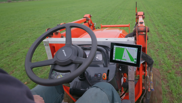
Topcon Agriculture has released its new Value Line Steering solution for farmers using mid-range tractors on small- to medium-sized farms. The new offering represents a significant step in making autosteering technology, typically used on larger machinery, accessible to a broader range of farmers.
“With the Value Line, we are opening up opportunities for farmers who have older or smaller machinery, or smaller specialty farms, to boost the value of their machinery, with autosteering technology that is based on our proven premium steering technology used for decades on larger machines,” said Antonio Marzia, executive vice president, Topcon Agriculture. “It is an integrated system designed to seamlessly work with a variety of tractors, including compliance with ISOBUS-UT functionality to offer universal compatibility and ease of use. Our goal is to provide high-quality, reliable, affordable, value-added technology that works across a wide range of applications, machinery and brands.”
The Value Line Steering solution is a comprehensive package that includes a GNSS receiver, electric steering wheel controller, touchscreen console and Horizon Lite software, compatible with front-wheel-steer tractors. Farmers also have the option to add local, satellite or RTK correction services such as Topcon’s Topnet Live for enhanced precision based on their unique needs.
Autosteering allows for more efficient use of resources, leading to reduced input costs for seeds, fertilizers, and fuel. This not only improves the farm’s bottom line but also contributes to more sustainable farming practices. The increased accuracy in field operations can also lead to improved crop yields, further enhancing profitability.
Farmers from various agricultural sectors, including commodity crops, specialty crops, and mixed farming systems, can expect significant benefits in their operations when adopting the technology.
The Value Line Steering solution is available through Topcon Agriculture’s global network of authorized dealers.
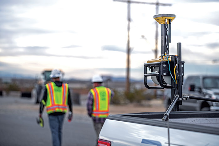
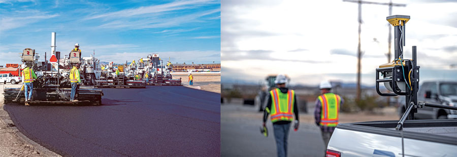
GNSS links the three steps in this example paving system. The mobile scanning system creates a 3D model that the grinding and paving equipment systems use. (Image: Topcon)
Even construction projects that involve separate pieces of heavy equipment can be tightly coupled, with GNSS as the “glue.” One example is Topcon’s SmoothRide paving system. The separate active steps of grinding and paving are working from a 3D model developed in a first step: precise mobile scanning. Each step constrains (horizontally) with GNSS, and vertically to the corresponding position in the model. In this example, the premium is on the quality of the scan.
For the first step, an RD-M1 scanner, usually attached to a pickup truck, can scan at highway speeds. The positioning component is an integrated HiPer SR GNSS receiver and inertial measurement unit (IMU). The GNSS observations, IMU data, and velocity from a wheel encoder are post-processed (PPK) together, to provide a high-definition 3D model with very tight relative integrity.
“A great lateral benefit of scanning in this manner is that it can be done quickly and also gives you a model of the area surrounding the road,” said Mark Larranaga, director, Intelligent Paving Business Development. “You get the terrain for drainage design, guardrails, signs, road furniture — everything you might need for good roadway design.”
For base data for the post-processing, Larranaga said a GNSS base typically will be set up on the site, though if a permanent base from a network such as TopNet is nearby, that can be used.
“The model is then created in MAGNET Collage software,” Larranaga said. “That produces the surface file. Once we get that created, we take it into a software called MAGNET Resurfacing. It is used to design for cross slope correction, or a smoothness factor, as well as material management — the software will do all this automatically. The software empowers the customer to create a file for the machine that will maximize the potential of the end results, based on the project parameters. Thus, allowing the contractor to evaluate and learn about potential pitfalls and maximizing incentives.”
The next step, using roadway surface grinding equipment, employs a two-antenna GNSS system (for position and heading). A sonic sensor is keyed to the corresponding elevations in the 3D model and informs the depth for which the grinder is set. The third step, paving, is quite similar: GNSS and a sonic sensor constrained by the precise 3D model. There are some implementations that add thermal cameras and look behind a paving machine to see whether certain target specifications are met in real time.
A roundup of recent products in the GNSS and inertial positioning industry from the July 2021 issue of GPS World magazine.
OEM
GNSS/INS Sensors
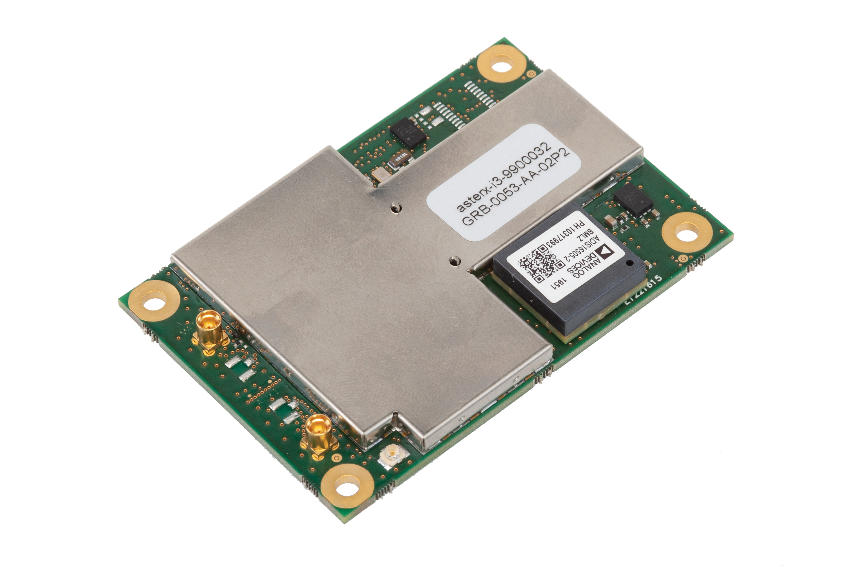
Photo: Septentrio
Five receivers in new product line
The AsteRx-i3 product family provides an array of next-generation receivers, from plug-and-play navigation solutions to feature-rich receivers with raw measurement access. Included are OEM boards and ruggedized receivers enclosed in a waterproof IP68 housing. The Pro receivers offer high accuracy positioning with 3D orientation and dead-reckoning for plug-and-play integrations. Pro+ receivers provide integrated positioning and orientation along with raw measurements, in single- or dual-antenna configurations, suitable for applications with sensor fusion. One of the receivers offers an off-board inertial measurement unit (IMU), which can be mounted exactly at the alignment point of interest.
The RES 720 GNSS dual-frequency embedded timing module provides next-generation networks with 5-nanosecond accuracy. It uses L1 and L5 GNSS signals to provide superior protection to jamming and spoofing, mitigates multipath in harsh environments, and adds security features to make it suitable for resilient networks. At 19 x 19 millimeters, the RES 720 is suitable for 5G Open Radio Access Networks (RAN)/XHaul, smart grids, data centers, industrial automation and satellite communication networks, as well as calibration services and perimeter monitoring applications.
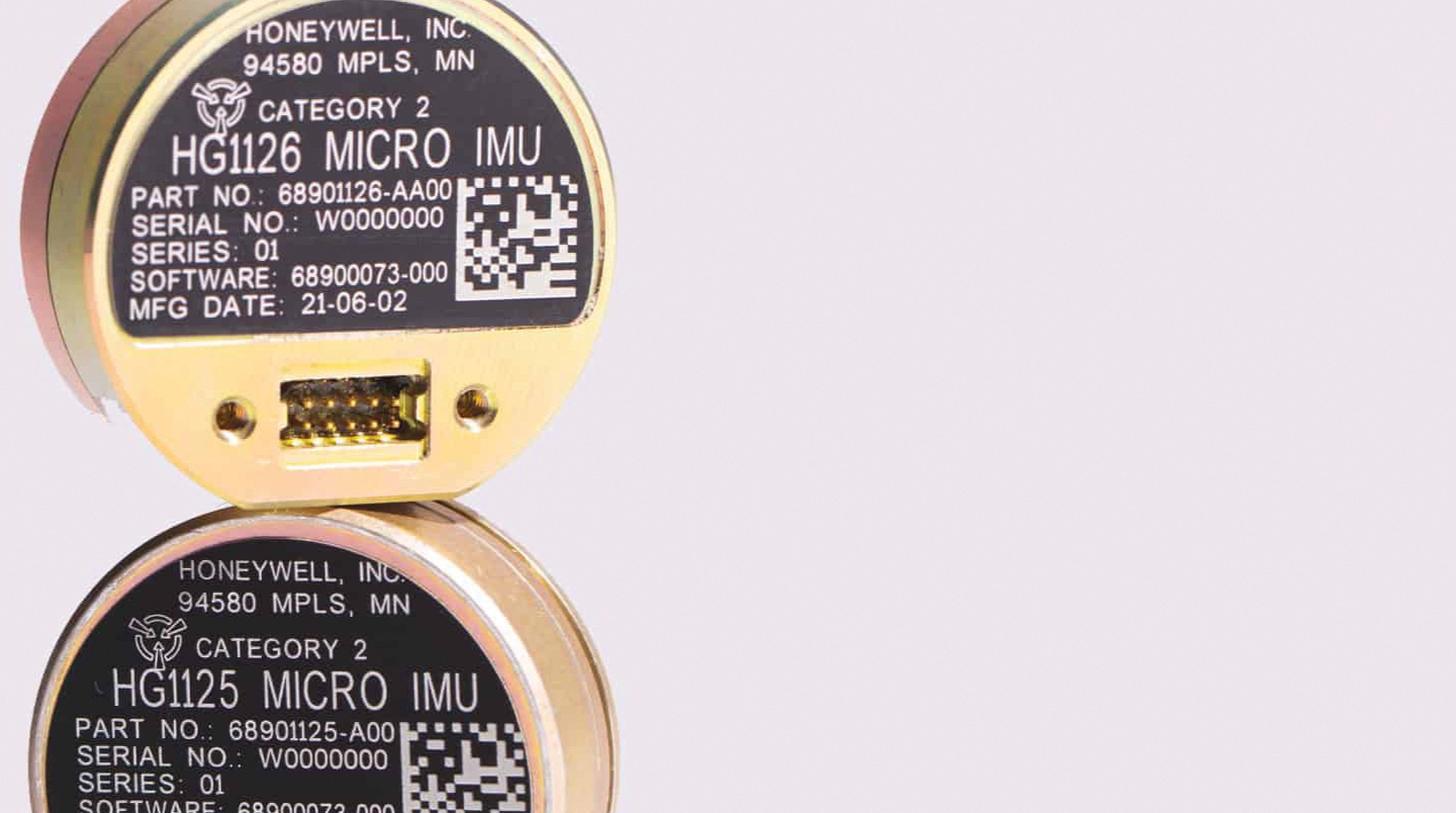
The new HG1125 and HG1126 IMUs are low-cost inertial measurement units that serve both commercial and military applications. They use sensors based on micro-electromechanical systems (MEMS) technology to precisely measure motion. They can survive shocks up to 40,000 G-force. The HG1125 and HG1126 can be used for a variety of defense and commercial applications, such as tactical military needs, drilling, unmanned aerial vehicles or navigation systems for general aviation aircraft.
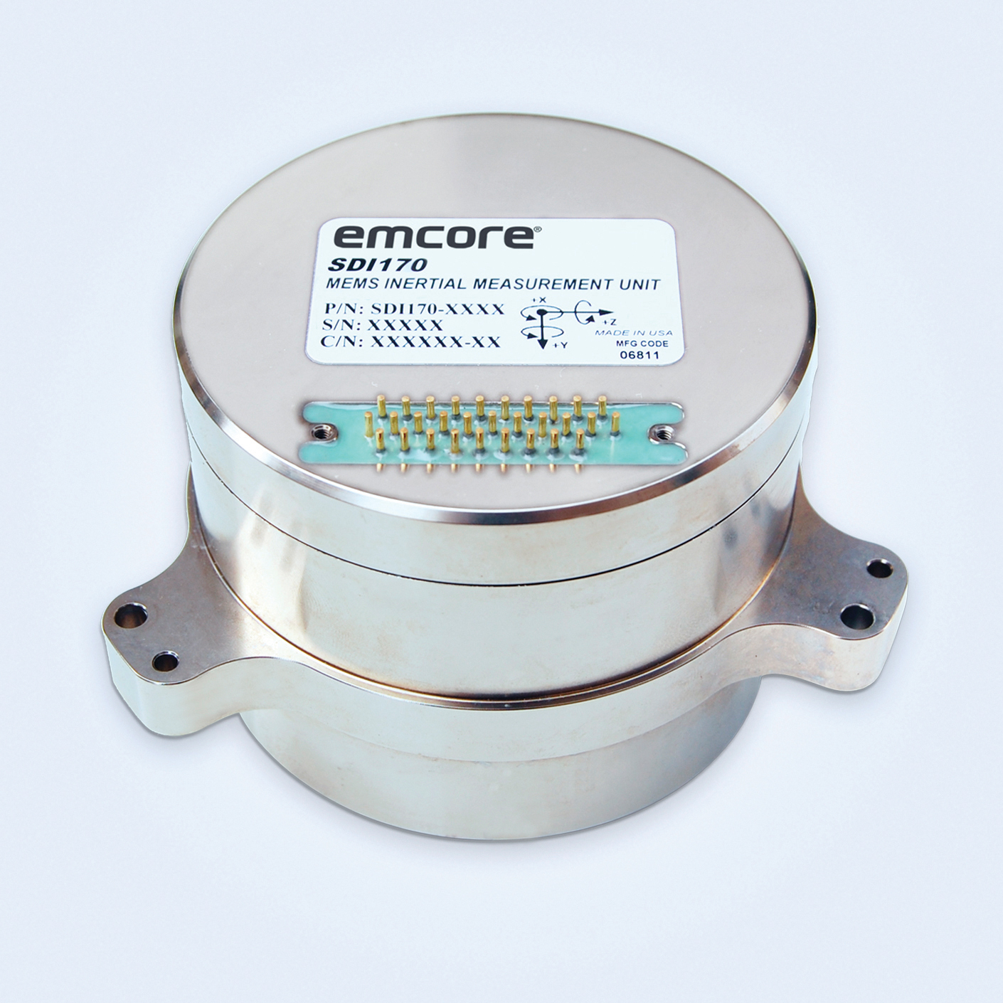
The SDI170 quartz MEMS tactical-grade IMU is designed as a form-, fit- and function-compatible replacement for the HG1700-AG58 ring-laser gyroscope (RLG) IMU, but with superior overall performance, versatility and a significantly higher mean time between failures (MTBF) rating over ruggedized environments. The SDI170 IMU delivers highly linear accelerometer performance and longer life compared to the HG1700 IMU.
The OSA 5405-MB is a compact outdoor precision time protocol (PTP) grandmaster clock with a multi-band GNSS receiver and an integrated antenna. It ensures timing accuracy by eliminating the impact of ionospheric delay variation, enabling communication service providers and enterprises to deliver the nanosecond precision needed for 5G fronthaul and other time-sensitive applications. A multi-constellation GNSS receiver and antenna enable the OSA 5405-MB to meet PRTC-B accuracy requirements (+/–40 nanoseconds) even in challenging conditions. It receives GNSS signals in two frequency bands, using the differences between them to calculate and compensate for ionospheric delay variation. The OSA 5405-MB is resilient against jamming and spoofing, considered critical for 5G synchronization. It can work with up to four GNSS constellations concurrently (GPS, Galileo, GLONASS and BeiDou).
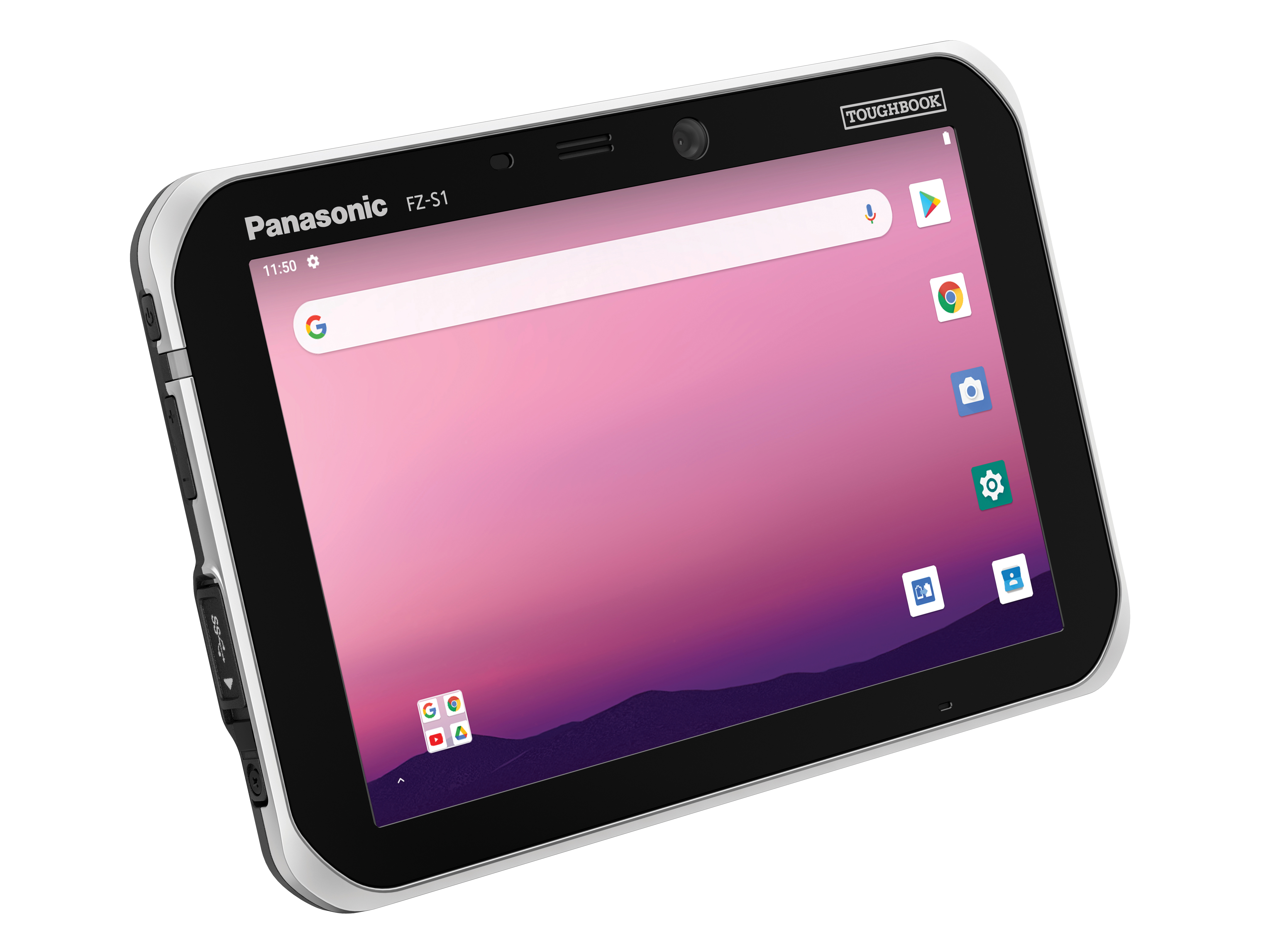
The Toughbook S1 is a fully rugged 7-inch Android tablet for capturing and accessing critical information in the field. GPS and LTE come optionally. The tablet is supported by Productivity+, a comprehensive Android ecosystem that enables customers to develop, deploy and sustain the Android OS environment in the enterprise. The Toughbook S1 tablet’s compact, rugged and lightweight body is made for portability and reliability for field workers. It has a 14-hour battery life and warm swap battery. Features include a sleek outdoor-readable anti-reflection screen, patented rain mode and multi-touch performance whether using a stylus, finger or glove.
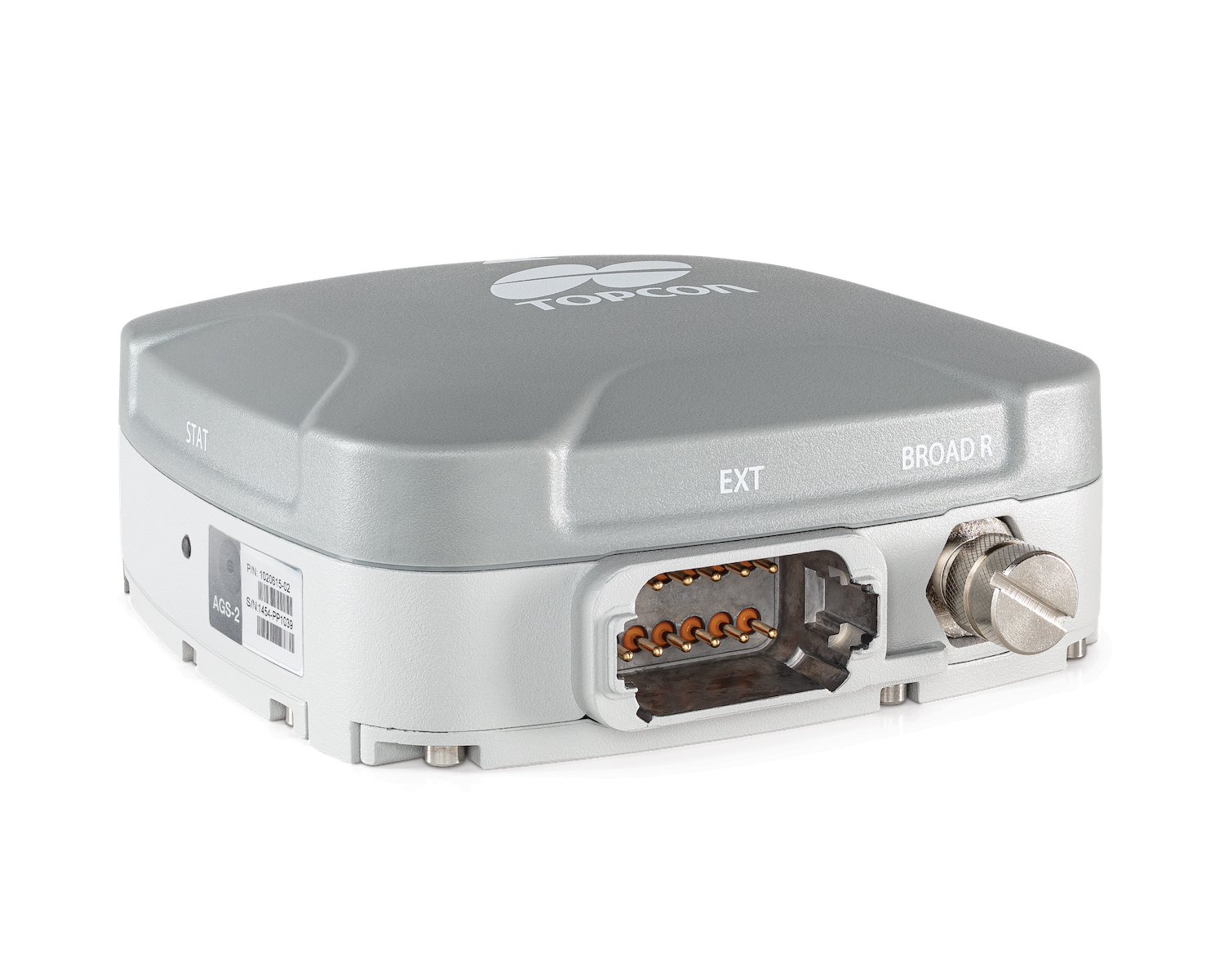
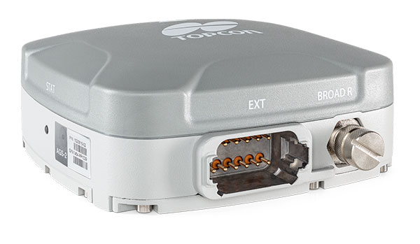
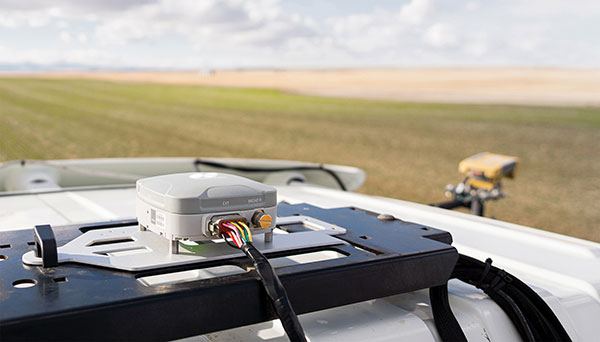
The AGS-2 and AGM-1 are manual guidance and autosteering receivers. Location data enable crop optimization, including soil preparation, seeding, crop care and harvesting. Designed to suit virtually any agricultural machine type, make and model, the AGS-2 receiver and steering controller combines steering with network reception and tracking. It comes standard with DGNSS correction services and is upgradeable using NTRIP and an optional RTK radio in the Topcon CL-55 cloud connectivity device. The AGM-1 is offered as an economical entry-level manual-guidance receiver.
Provides fast data processing for construction and surveying
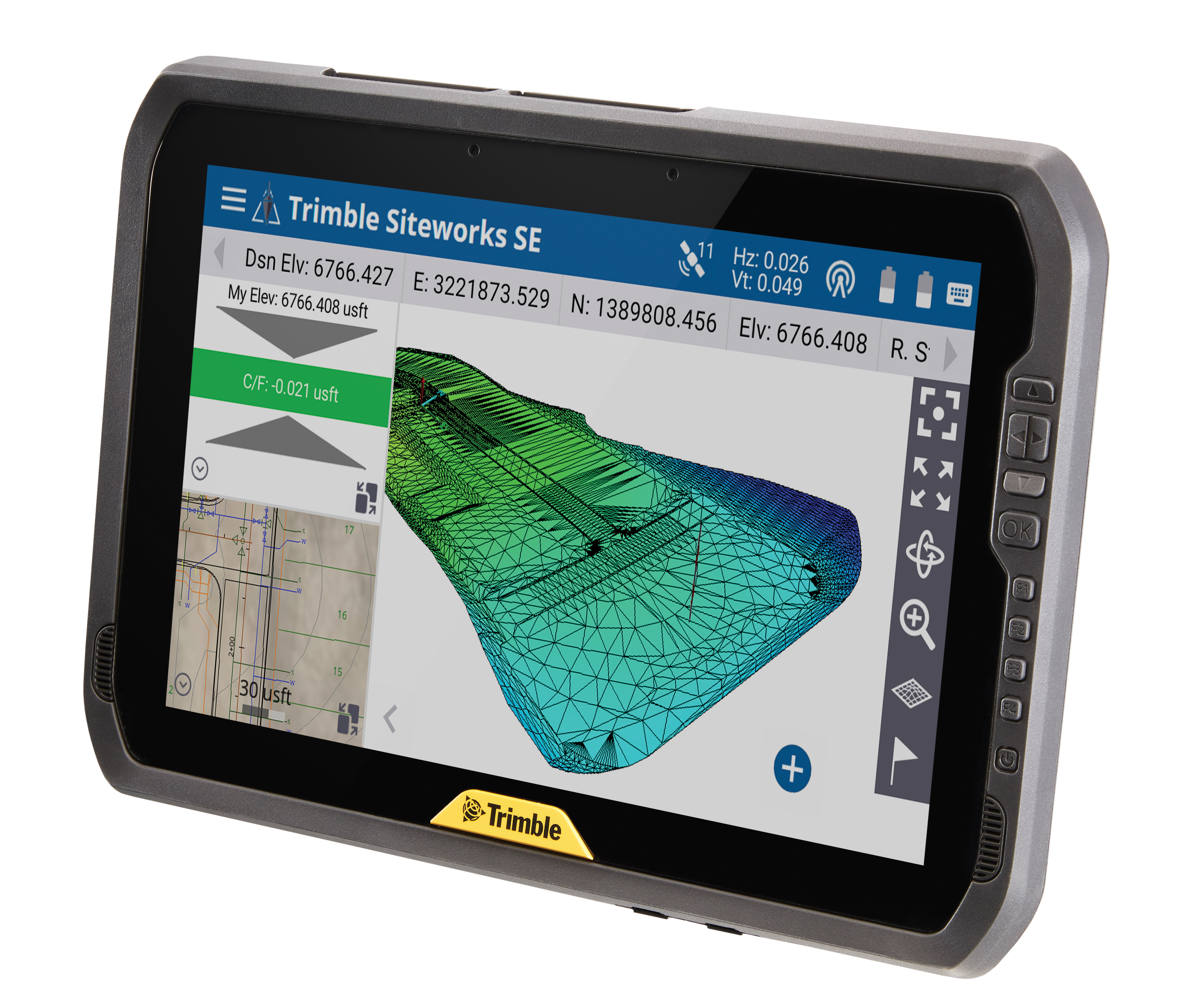
The Trimble T100 high-performance tablet is suitable for both experienced and novice users. It is optimized for Trimble Siteworks Software and supporting office applications such as Trimble Business Center. Its accessories are designed to complement user workflows, enabling users to complete quality assurance and quality control before leaving the field. The tablet is designed to be flexible and usable in a variety of configurations and job sites. It is engineered to be ergonomic and portable on and off the pole. Features include a 10-inch (25.4 cm) sunlight-readable touchscreen display, a directional keypad with programmable function keys and a 92-Wh internal battery.
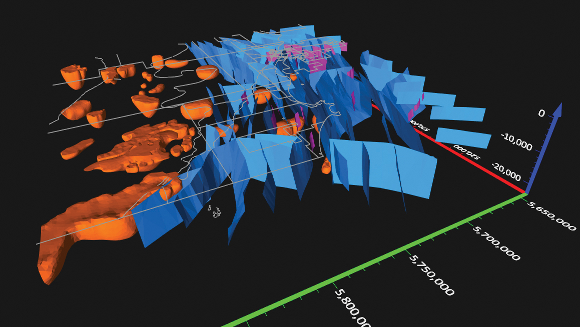
Surfer has new gridding, contouring and surface mapping software to make it easier for users to visualize, display and analyze complex 3D data. Surfer enables users to model data sets, apply an array of advanced analytics tools, and graphically communicate the results. The scientific modeling package is used in oil and gas exploration, environmental consulting, mining, engineering and geospatial projects. Enhancements have been made to 3D Base Maps, Contour Volume/Area Calculation, 3D PDF Exporting Options and automated features for creation of scripts and workflows.
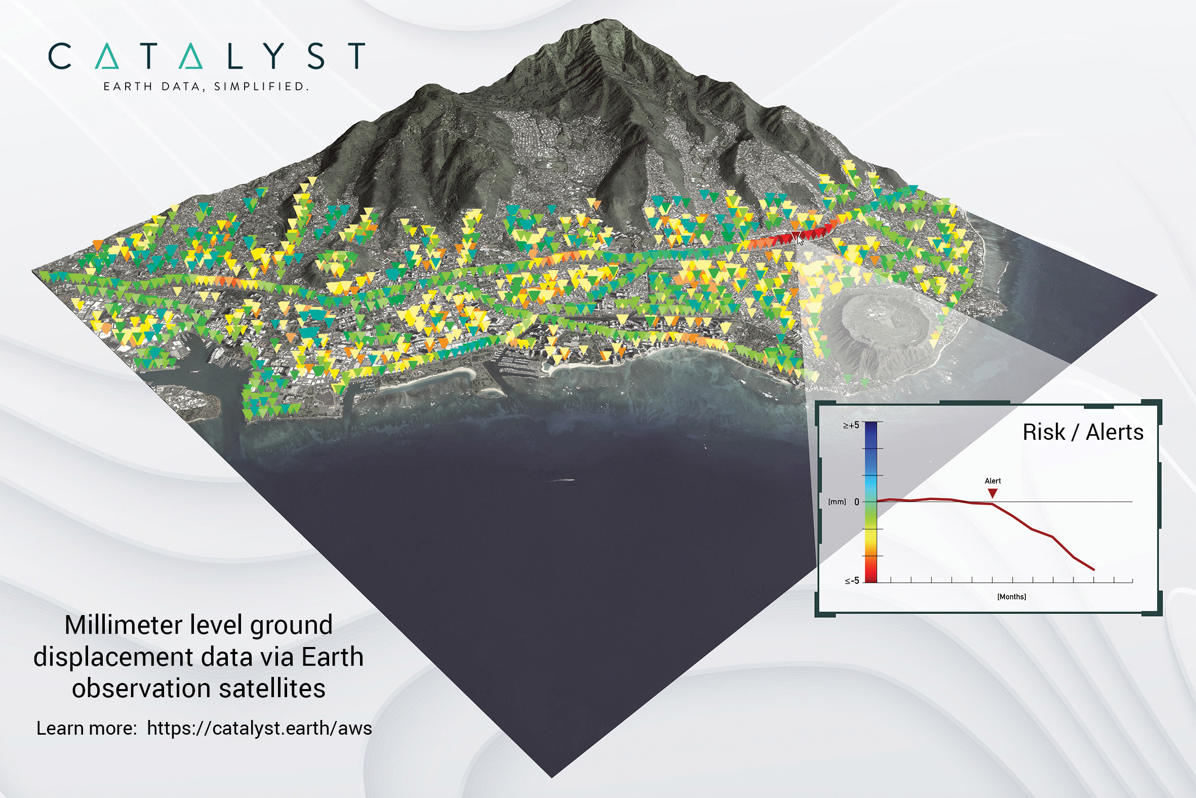
A Catalyst-AWS collaboration delivers actionable geoscience analytics to users, providing satellite-based Earth observation intelligence. The data and analytics are delivered via Amazon Web Services (AWS) Cloud. Catalyst is a PCI Geomatics brand. The initial solution, available through AWS Data Exchange, is an infrastructure risk-assessment service that uses satellite data to continuously monitor millimeter-level ground displacement over a subscriber’s area of interest anywhere on Earth. Catalyst is exploring additional risk mitigation solutions and monitoring services using AWS. Having image processing science and imagery on the cloud reduces latency and costly data transfers.
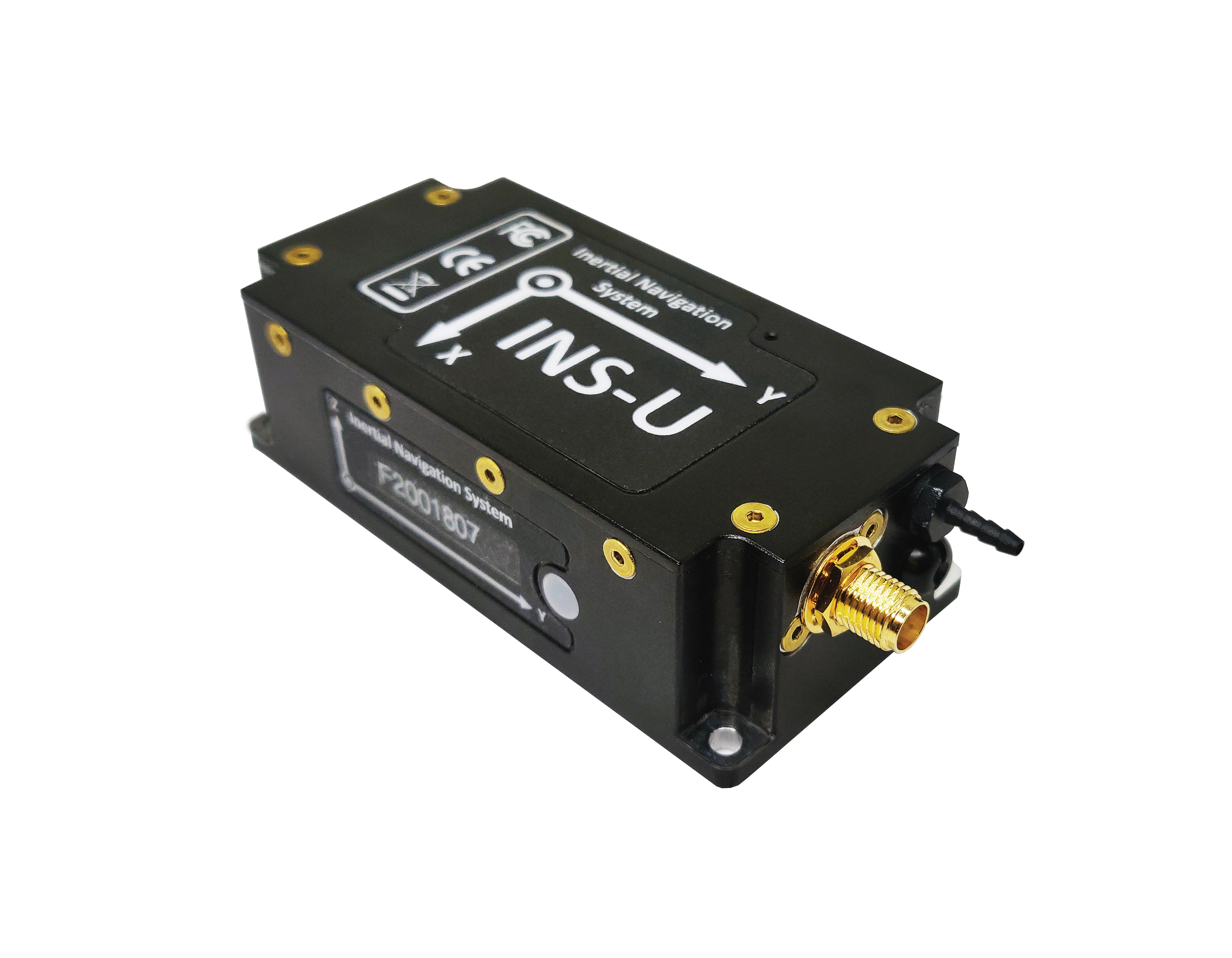
The GPS-aided INS-U is a fully integrated attitude and heading reference system (AHRS), IMU and air-data computer high-performance strapdown system that determines position, navigation and timing information for any device on which it is mounted. The INS-U uses a single antenna, multi-constellation u-blox GNSS receiver. With access to GPS, GLONASS, Galileo, QZSS and BeiDou, the INS-U can be used in a variety of GPS-enabled environments and is protected against spoofing and jamming. The INS-U has two barometers, a miniature gyro-compensated fluxgate compass, and tri-axis temperature-calibrated advanced MEMS accelerometers and gyroscopes. These high-performance sensors, along with Inertial Labs’ new on-board sensor-fusion filter, and state-of-the-art guidance and navigation algorithms, provide accurate position, velocity and orientation of the device under measurement.
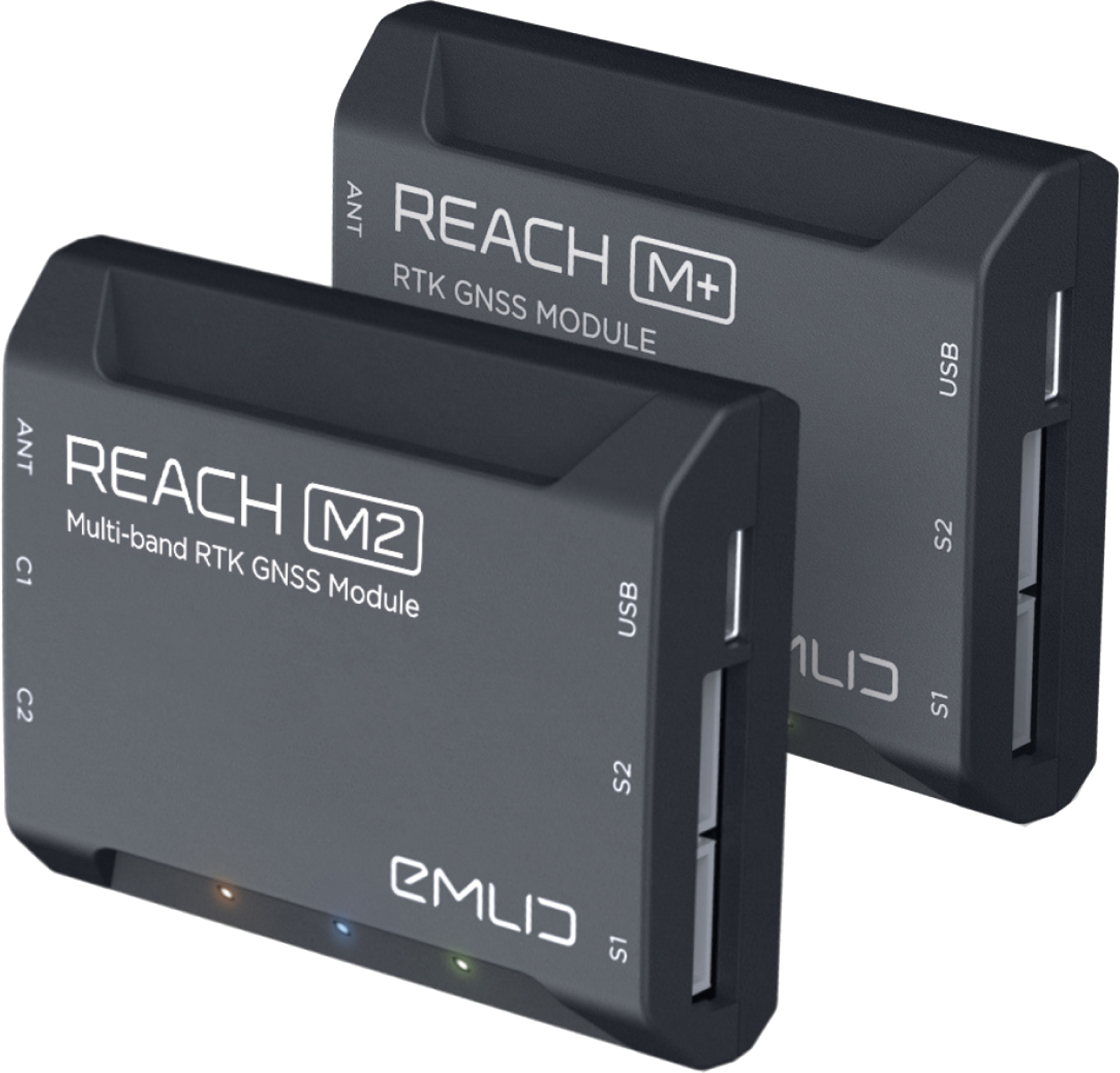
The Reach M+ and Reach M2 positioning modules for UAV mapping provide centimeter-level accuracy in real-time kinematic (RTK) and post-processed kinematic (PPK) modes, enabling precise UAV mapping with fewer ground control points. The Reach M+ single-band receiver has a baseline up to 20 kilometers in PPK. The Reach M2 is a multi-band receiver with a baseline up to 100 kilometers in PPK. Reach connects directly to a camera’s hot-shoe port and is synced with the shutter. Time and coordinates of each photo are logged with a resolution of less than a microsecond. Reach captures flash sync pulses with sub-microsecond resolution and stores them in a raw data RINEX log in the internal memory. This method allows ground control points to be used only to check accuracy.
System simplifies drone inspection missions, deliveries
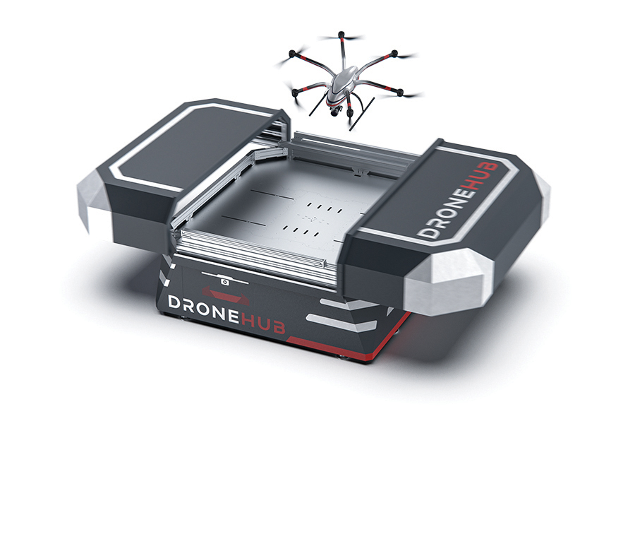
The Dronehub is an automated solution that can provide undisturbed drone service 24/7 in nearly any weather condition. With the integration of IBM artificial intelligence technology, Dronehub solutions can operate and automatically provide information with little human interaction. The system includes the drone and a docking station with automatic battery replacement. It can fly for 45 minutes in +/–45° C weather, up to 35 km in winds up to 15 m/s. It can carry a payload up to 5 kg as far as 15 km. It can be used for monitoring, inspection and measurement; cargo transport and parcel deliveries; and mobile ground infrastructure; and security.
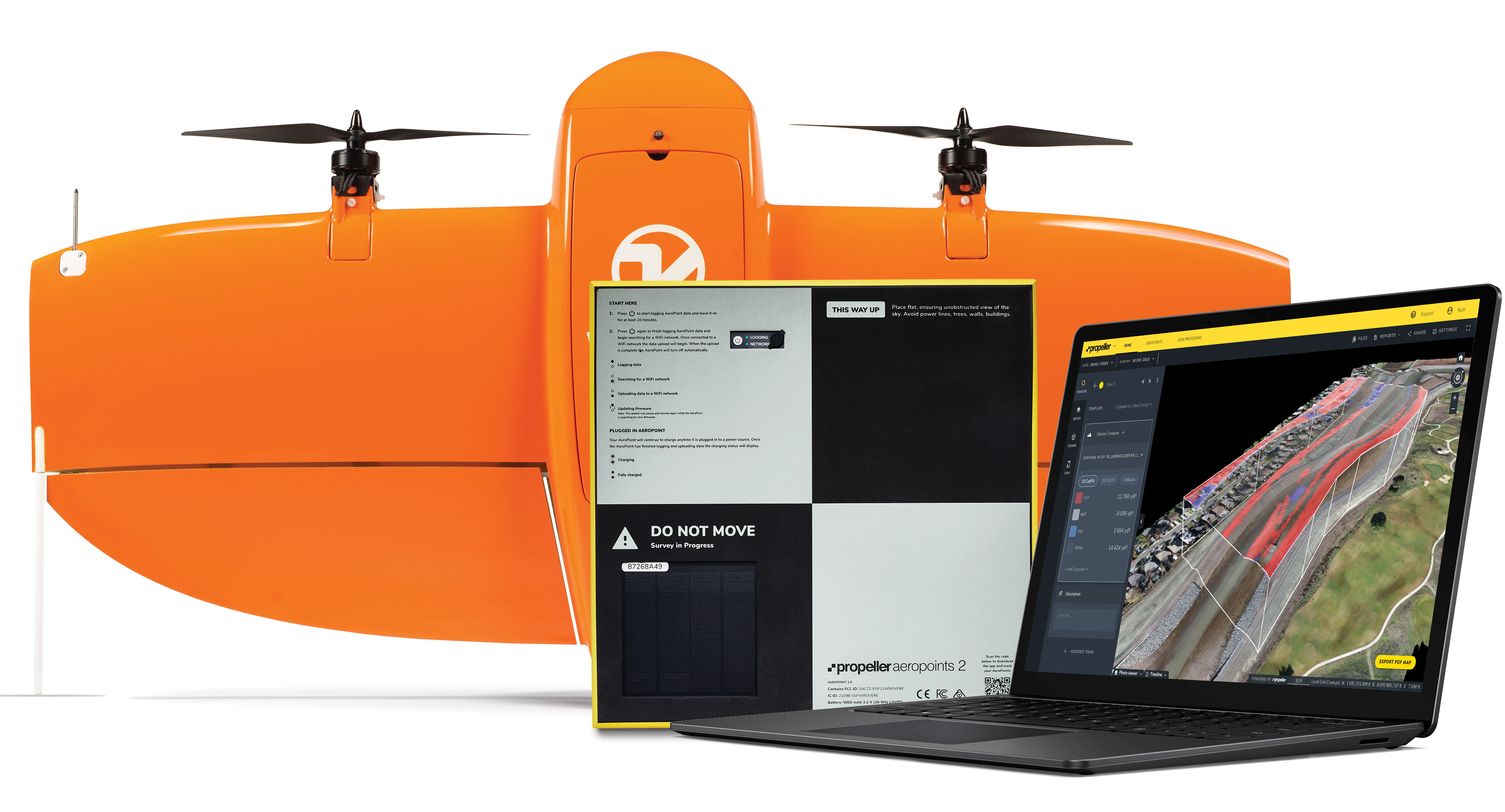
The Propeller Platform and WingtraOne drone package enable construction professionals to collect survey-grade data across the worksite consistently and accurately. To operate, surveyors place Propeller AeroPoints (smart ground-control points) on their worksite, and then fly the WingtraOne drone to collect worksite survey data. Survey images are uploaded to Propeller’s cloud-based platform, where the fully automated geotagging and photogrammetry processing is completed within 24 hours of submission on the platform. Uses include mines, road and railway projects, highways and industrial complexes. Data collection with AeroPoints and Propeller PPK can serve as a reliable, single source for survey data and progress. Teams across the entire worksite can view geographically accurate and realistic 3D site models and track, inspect and report on job progress and productivity safely and accurately.
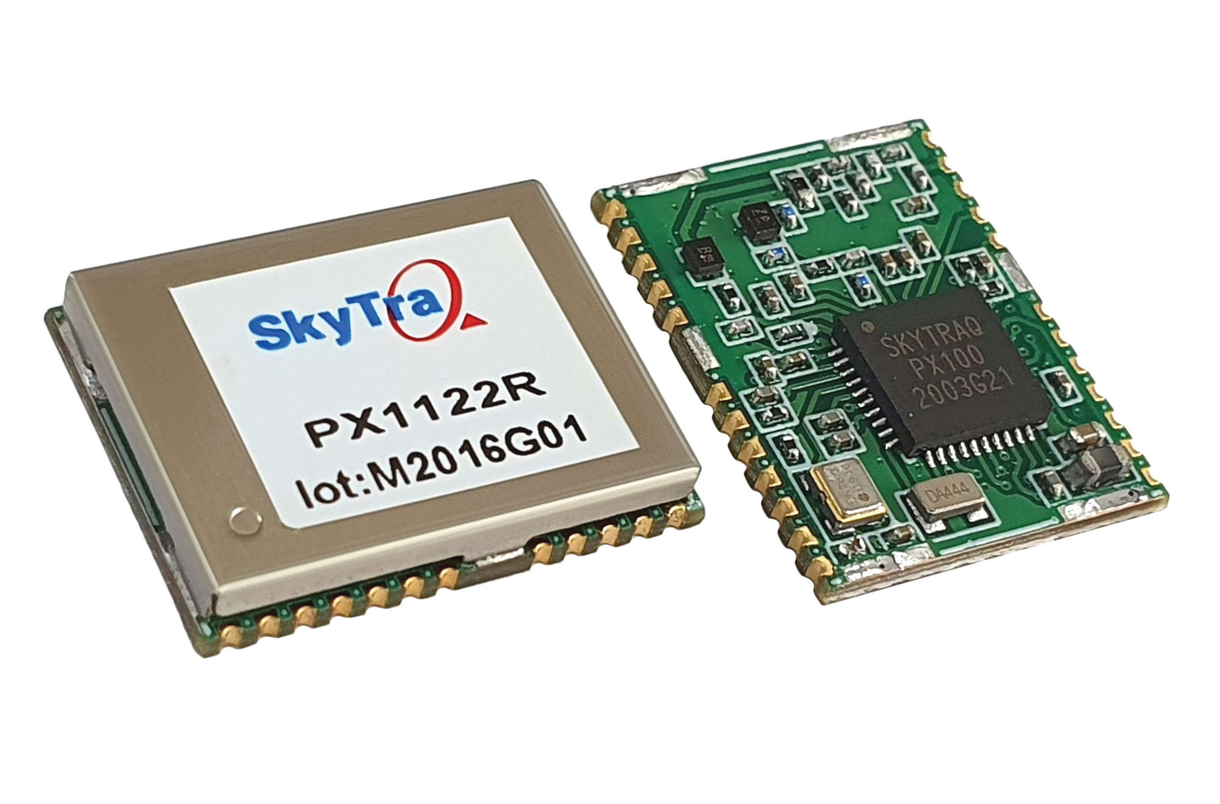
Stamp-sized module provides RTK positioning and heading
The PX1122R is a high-performance multi-band quad-GNSS real-time kinematic (RTK) receiver featuring 1 cm + 1 ppm position accuracy and under 10-second RTK convergence. It has a 12 x 16 millimeter form factor, about the size of a postage stamp. It can be configured for a base or a rover, and supports a moving base RTK for precision heading applications. The PX1122R has a maximum quad-GNSS RTK update rate of 10 Hz, providing a quick response time and more stable performance for fast-moving precision guidance applications.
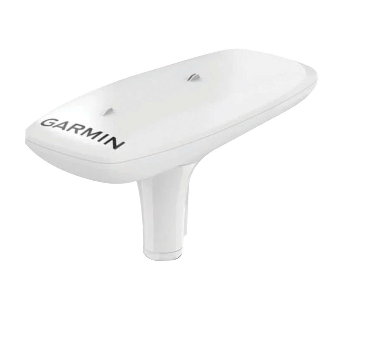
Utilizing both L1 and L5 GPS frequencies, along with multi-constellation support (GPS, Galileo, GLONASS and BeiDou), the MSC 10 marine satellite compass provides precise positioning and heading accuracy within 2 degrees. Its 10-Hz position update rate delivers detailed tracking information. It eliminates magnetic interference, which can degrade heading accuracy. The MSC 10 is easy to install and can be used as the primary position and heading sensor across multiple systems, including autopilots. If the satellite signal is lost, it will transition from GPS-based to a backup magnetometer-based heading.
Topcon Agriculture is offering new manual guidance and autosteering receivers — the AGM-1 and AGS-2.
Topcon also launched Topnet Live, a real-time GNSS correction service. Under Topnet Live, the Realpoint service provides greater accuracy and a quick start-up time. Starpoint and Starpoint Pro provide service anywhere on the planet, independent of local networks. Skybridge allows subscribers to combine RTK and PPP correction services.
Accurate positioning is the cornerstone of site-specific management. It is not only required for accurate operations, but expansive data collection, enabling farm professionals to compare different types of information, such as yield, soil type and fertility, for better decision making.
The technology is used for machine operations and all associated tasks where tracking location data is relevant to crop optimization, including soil preparation, seeding, crop care and harvesting.
Photo: Topcon
Topnet Live. To support the range of agricultural applications, the receiver and steering controller uses the new Topnet Live correction services. Plus, with the option of Skybridge, users can maintain network connection during any RTK interruption.
“Topcon receivers are designed to suit virtually any agricultural machine type, make and model,” said Brian Sorbe, vice president of global product solutions. “Equipped with progressive reception and tracking capabilities, with the option of manual guidance or complete autosteering, the receivers are suitable for any size or type of operation. With access to the full range of correction services through the AGS-2, Topcon provides farmers with the right fit for their operation with accuracy on demand. Each unique farming operation may have differing accuracy requirements and this approach will benefit their operation.
“Calibrated to accuracies of within two centimeters, the new correction services provide reliable pass-to-pass precision,” Sorbe said. “Through a constantly improving network and variety of cost-effective subscription models, the service delivers reliable connection stability across the globe. With these new offerings, Topcon continues to offer powerful solutions to suit the variable demands of agriculture.”
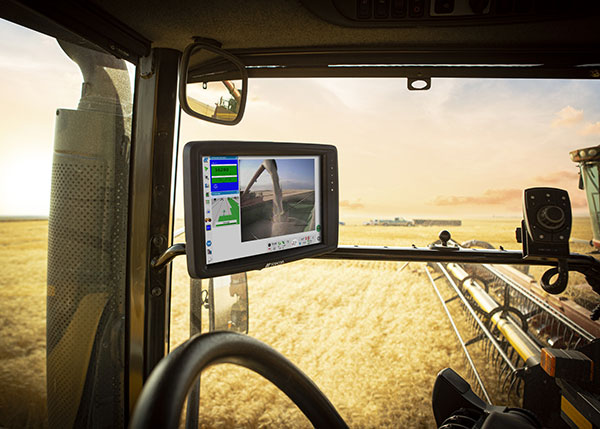
Topcon Agriculture has released new in-cab displays — XD and XD+ touchscreen consoles — with an upgraded user interface experience, Horizon 5.
With Topcon Agriculture Platform (TAP) integration, the consoles are designed to provide farmers with full-feature customization to optimize their investment by paying only for capabilities they need.
“As a farmer’s needs grow, often times they’ve had to use multiple single-function consoles. In recent years, Topcon has offered the X family of consoles designed with all-in-one capability to resolve this issue, reducing clutter, improving setup, updates, support, and reducing overall hardware costs,” said Brian Sorbe, vice president of global production solutions. “Now with the additions to the series, Topcon is further simplifying cab control and it’s a modular approach with future needs in mind for each unique farming operation.”
Farmers can immediately take advantage of off-the-shelf features such as basic guidance, task management, universal ISO-UT compatibility, and TAP Fields to manage farm data. Additional features are unlockable for use with the full range of Topcon sensors and application control technology.
“TAP is a digital farm management system and it’s a way for a farmer to organize, visualize and make decisions and it begins with the touch of the console in the cab, and now with the new user interface and digital system all integrated, it will be simpler and easier to setup and get to work,” Sorbe said.
The new consoles are designed to be ready for any application such as soil preparation, seeding, crop care, harvest, weighing and data services.
The consoles are available in 7-inch and 12.1-inch screens, including new day and night modes.
Topcon Agriculture and CropZilla have signed a licensing agreement for use of the Topcon Agriculture Platform (TAP) application programming interface (API) in the CropZilla Web Mobile Analytics platforms.
TAP is a software-to-software interface designed to benefit the end-user by providing a simple and seamless way for sharing data between software systems.
With the Topcon interface, CropZilla is able to acquire machine data from a common device on the machine, adding simplicity and value to each grower wanting to utilize both tools to manage data. Users simply create an account with TAP and CropZilla and the data sharing is effortless, the companies said.
“Topcon’s strategy as it relates to our new digital solution platform is one of partnerships, connectivity, and collaboration. This partnership with CropZilla is the first step of several towards deeper integration with a premier colleague and embodies our philosophy ideally. It demonstrates that two companies can collaborate to provide additional value to the producer, dealer, and OEM,” said Brian Sorbe, VP and GM for Topcon Agriculture.
Brian Watkins, CEO of CropZilla, said, “We’re excited to add Topcon Ag to our expanding ecosystem of partners for CropZilla. We have a common desire with Topcon to create immense value to growers as painlessly as possible. This is only the first step and is a great example of that in action.”
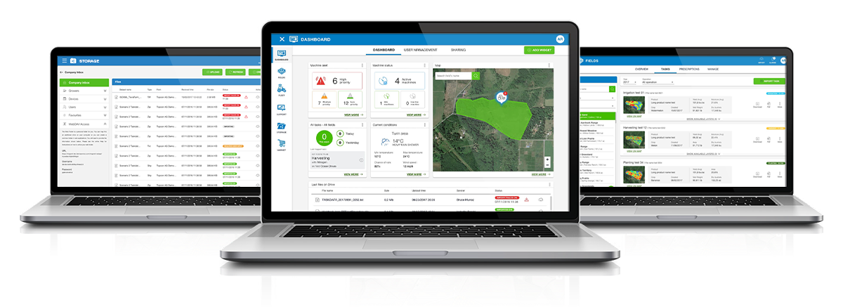
Topcon Agriculture launched a number of digital farm management tools, including updates to the Topcon Agriculture Platform. (Photo: Topcon)
Topcon Agriculture launched a number of digital farm management tools, including updates to its cloud-based farm management platform, Topcon Agriculture Platform (TAP). According to the company, the platform integrates state-of-the-art connectivity, cloud services and data analytics. The package is designed to suit virtually any agricultural machine, implement or technology, Topcon added.
The Topcon Agriculture Platform features a new interface designed to increase productivity and profitability for farmers. It also has the ability to provide data on a number of variables, including yield, soil, fertility, imagery and topography.
“We’ve worked with farmers and institutions while beta testing and are excited to roll the platform out to farmers worldwide,” said Brian Sorbe, vice president of global production solutions for Topcon. “It is the ideal solution for mixed fleets, so farmers can focus solely on decisions and action.
“Additionally, the platform can provide seamless connectivity for sharing information so those supporting the farmers, such as dealers and agronomists, can provide real-time support, recommendations and tasks directly to the cab.”
The company also released yield data management tools, an autosteering tool and a GNSS base receiver. The company’s Smart Cart solution is designed to provide farmers with the capability to gather highly accurate, weight-verified, geo-referenced harvest data that automatically uploads to TAP for visualizing, post processing and yield reporting, the company said.
The other yield monitoring solution released by Topcon is the YM-2 YieldTrakk. This system services crops using conveyor-type harvesters, such as potatoes, sugar beets, grapes, onions and tomatoes.
Topcon debuted the HiPer VR mobile base station to provide the latest GNSS tracking technology and RTK capability in a compact, rugged design to bring satellite guidance and value to any agricultural application, as well.
Finally, the company launched its AGS-2 auto guidance system, which provides autosteering for agricultural machine types and models.
“For increased flexibility and connectivity, the system will leverage the new TAP Cloudlynk connectivity devices for RTK corrections via cellular or radio,” Sorbe said. “A major benefit is the introduction of new TopNET Global signal options and SkyBridge, which will reduce downtime by allowing the system to continue steering due to signal coverage interruption’s when using RTK.”
According to the company, Topcon Agriculture Platform subscriptions and cloud connectivity devices — Cloudlynk — will be available worldwide September 2019.
Industry experts share how GNSS can be used for precision agriculture.
Vazquez
EUROPEAN SATELLITE SERVICES PROVIDER (ESSP)
Juan Vazquez Team Leader, EDAS Service Provision
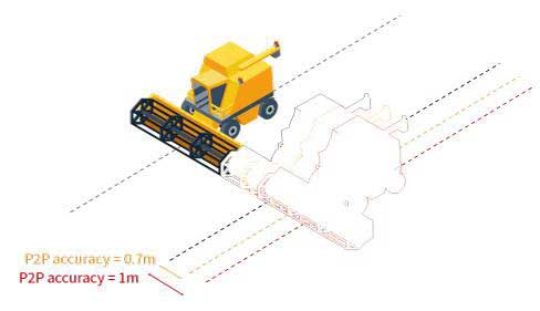
Pass-to-pass accuracy is the key performance indicator to assess the precision of guidance systems, characterizing the short-term dynamic performance determined from off-track errors along the straight segment passes (error with respect to the desired path in the direction perpendicular to the tractor trajectory).
The results of the tests reported in this article, jointly performed by Topcon Agriculture and ESSP, confirm that EDAS DGPS corrections can support a wide range of precision agriculture applications and represent a real alternative for cereal farms, when located in the vicinity (at least up to 260 km away) of an EGNOS reference station, complementing the benefits that the EGNOS signal-in-space is already providing to a large number of agriculture users in Europe.
EFFIGIS GEO-SOLUTIONS
Nicos Keable-Vézina Director of Precision Agriculture
Thanks to artificial intelligence, variable-rate application of nitrogen has made great strides in recent years. Science has demonstrated that effective nitrogen management requires an array of technologies, including massive databases. Data is geospatial (positioning signal and satellite imagery enabling the identification of changes in nitrogen requirements), agronomic (mainly soil texture and seasonal weather), and economic (grain and nitrogen price).
To automate extraction and analysis of such data, combining very low-cost positioning technologies, satellite imagery and artificial intelligence is paramount. A democratized access to technology has led to the development of scientifically proven nitrogen prescribing platforms, among them FieldApex, that calculate the most profitable nitrogen rates and generate prescriptions in seconds without soil sampling. Further technological and platform integrations are likely to bolster such innovation.
Rioja
TOPCON AGRICULTURE
Julian Rioja Channel Development and Business Intelligence Manager
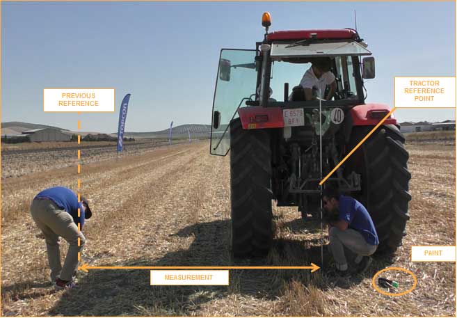
All tests were performed using Topcon receivers, vehicles and auto-steering systems. Two different Topcon guidance systems on board tractors ran simultaneously to assess the EDAS DGPS positioning performance with respect to the reference provided by a real-time kinematic (RTK) system. Hence, two independent positioning outputs were continuously available (the receivers were placed along the same longitudinal axis on the roof of the tractor):
RTK position: provided by the AGI-4 receiver fed by Topcon’s Hiper V RTK base.
DGPS position: provided by the AGI-4 receiver fed by the EDAS Ntrip service.
On board the tractor, two Topcon X35 consoles were each connected to one of the receivers. A Topcon AES-25 electric steering system was installed on the tractor so that the selected navigation input (RTK or EDAS DGPS) could be used to automatically guide the tractor along the defined reference pattern.
McClure
HEMISPHERE GNSS
John McClure Engineering Manager, Precision Agriculture
Precision agriculture is expanding the use of ISOBUS for CAN communication between a common terminal and implements, to reduce clutter in the cab. These virtual terminals now act as display and user entry for multiple applications including GNSS receivers and factory or after-market steering systems.
INS-aided GNSS solutions, typically using RTK or satellite-based correctors such as Atlas, provide time/position data for rate and section control and auto-steering. CAN-based NMEA 2000 is the commonly used receiver protocol for position data, replacing serial NMEA 0183.
All major tractor, agricultural equipment, and GNSS manufacturers attend regular “Plugfest” meetings, organized by the Agriculture Industry Electronics Foundation, to test interoperability of products and set common standards.
Smart CAN dongles are being developed to read sensors and control systems, supplying positioned data via telematics as the Big Data for real-time and post analysis.
By Juan Vázquez, Elisabet Lacarra, Jorge Morán and Miguel A. Sánchez, ESSP SAS, and Julian Rioja and Jimmy Bruzual, Topcon Agriculture
The European Geostationary Navigation Overlay Service (EGNOS), a satellite-based augmentation system (SBAS), provides corrections and integrity information to GPS signals over Europe and is fully interoperable with other SBAS such as North America’s WAAS. Among its services is the internet-based EGNOS Data Access Service (EDAS).
EDAS gathers raw data from GPS, GLONASS and EGNOS GEO satellites collected by receivers at approximately 40 EGNOS ground stations distributed over Europe and North Africa. EDAS reformats and disseminates GNSS data in real time and through an FTP archive to EDAS users and service providers.
Additionally, EDAS provides differential GNSS corrections to the GPS and GLONASS satellites in view by the EGNOS system network through its Ntrip service.
The tests summarized in this article focused on the EDAS Ntrip Service, which can be used for differential positioning. An earlier test near Seville, Spain, concluded that these corrections could support pass-to-pass accuracies in the order of 20 centimeters in a consistent manner and with a high degree of repeatability.
To assess EDAS performance validity for agriculture applications, two additional tests were done in Lisbon, Portugal, and York, UK. These locations provide diversity with respect to the Seville test, especially in terms of distance from the farm to the selected EGNOS reference station (≈320 km in York and 40 km in Lisbon, versus the 110 km baseline of the test in Seville) and also geographically. In all tests, a real-time kinematic solution operated in parallel to the EDAS DGPS solution to provide the required reference for the post-processing of the recorded data. Nine different runs with a total of 78 passes were performed in these two campaigns.
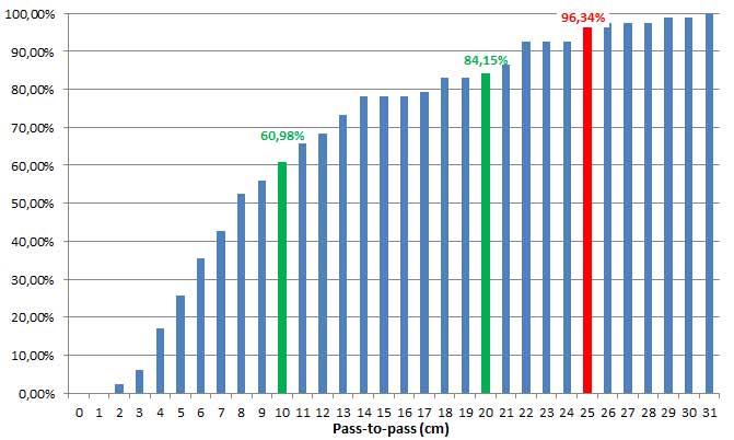
Considering the results from the three tests, the pass-to-pass accuracy supported by EDAS DGPS corrections was below 10 cm for more than 60% of passes and below 20 cm for more than 85 percent of the passes. These figures exceed the earlier results and confirm that EDAS DGPS corrections can deliver pass-to-pass accuracies in the order of 10 to 20 cm in a consistent manner.
Cumulative distribution of P2P accuracy, in centimeters. (Chart: Topcon)
The stability of the results and the very good pass-to-pass accuracy levels observed in the York scenario, where baselines larger than 300 km were tested, deserve highlighting. For grain and dry soil cultivation, at least 1 meter (95th percentile) of absolute horizontal accuracy is required. It can be assumed that, within the area where EDAS DGPS supports sub-meter horizontal accuracies (up to 260 km from the selected EGNOS station, according to previous studies), EDAS DGPS corrections can also support pass-to-pass accuracies in the order of 10-20 cm.
Such performance levels are considered to be appropriate for most grain farm operations. In particular, the observed performance is sufficient to support the following precision agriculture applications: