Topcon Positioning Germany is one of 22 partners involved in CampusOS, a research project with the goal of developing a modular ecosystem for open 5G campus networks based on open radio technologies and interoperable network components.
As part of the German technology program “Campus networks based on 5G communication technologies,” innovative solutions for open 5G networks are being developed and tested in conjunction with the German Federal Ministry for Economic Affairs and Climate Protection. The program was launched at the beginning of 2022 and will run through 2025.
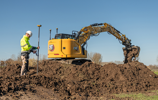
The use of artificial intelligence in the operation of autonomous plants and construction machinery requires the highest level of digital sovereignty. If Construction 4.0, including far-reaching automation, is to become a reality in Germany and the rest of the world, the processes of such data-driven solutions must run reliably, quickly and autonomously.
The German Federal Ministry for Economic Affairs and Climate Protection is providing €18.1 million in funding for the technology program over the next three years, which will cost €33 million total. The Fraunhofer Institutes FOKUS and HHI are coordinating the project. 22 partners from industry and research are involved, including Deutsche Telekom, Siemens, Robert Bosch and more.
“To enable companies to operate their own campus networks, certain requirements must be met; from standardized technology building blocks to network structures,” explained Ulrich Hermanski, chief marketing officer of the Topcon Positioning Group. “As the sole representative of the construction industry, Topcon will test the technologies on reference test sites and, therefore, will help shape the solutions for the future. We look forward to working with our research partners to take the digital construction site to the next level.”
With this research project, construction companies will one day be able to operate plants and machinery autonomously in open campus networks. This will allow the fluid and uninterrupted monitoring of construction sites in real time, as well as the networking of all sensors and construction machines in use on construction sites.
Autonomous from public networks, 5G technology guarantees seamless machine-to-machine communication and transmits data 10 times faster than 4G.
Topcon Positioning Group has announced its MC-Max machine control solution. Based on its MC-X machine control platform, and backed by Sitelink3D — the company’s real-time, cloud-based data management ecosystem — MC-Max is a scalable solution for mixed-fleet heavy equipment environments. It is designed to adapt to owners’ machine control and data integration needs as their fleets and workflows expand.
MC-Max increases processing power, speed, accuracy, versatility and reliability, Topcon said. It can be installed on a full range of dozers and excavators, using the same basic modular components. Modern, redesigned user and product interfaces were developed based on real-world applications and customer feedback and provide a simplified and immersive user experience that allows operators to easily learn the system.
Photo: Topcon
“With MC-Max, we’ve created a solution that is flexible and can continue to grow as a contractor’s needs and capabilities expand,” said Jamie Williamson, executive vice president, Topcon Positioning Group. “This new solution provides improved scalability and precision in the field and offers business owners real-time data integration, connectivity and resource management capabilities across their entire workflow.”
The MC-Max solution offers flexible mounting solutions, as well as optional automatic blade and bucket control for a variety of machines. The system also provides a full battery of positioning technologies ranging from slope control to laser, multi-constellation GNSS, robotic total station and millimeter GPS systems.
MC-Max provides project managers a real-time view of machine positions, activities and onsite progress, and is compatible with a wide range of site communications systems.
Topcon MC-X Platform. The Topcon MC-X Platform is designed to make machine control easy to use and affordable for contractors. The platform ties together mixed fleets by interacting with multiple versions of 3D-MC, providing connectivity to Sitelink3D and taking advantage of the multi-constellation capabilities of GNSS antennas.
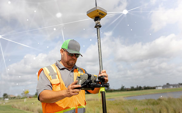
Topnet Live has increased types of correction services and subscription options. (Image: Topcon)
Topcon Positioning Group has expanded its Topnet Live GNSS network of correction solutions to support today’s work environments. The global network now has more types of correction services and subscription options.
This growth is a result of the increasing demand for digitalization in various industries including construction, surveying, machine control, and agriculture.
The flexible service options include Realpoint, the real-time kinematic (RTK) service, and Starpoint, a precise point positioning (PPP) service. The different services have varying delivery methods, coverage and reliable centimeter-level accuracy. Under a flexible subscription model, customers can purchase to suit their needs.
Additionally, Skybridge — an RTK service supported by PPP — is available to maintain connectivity and productivity if the customer temporarily leaves RTK coverage.
“The Topnet Live RTK network, first established over a decade ago, continues to grow with 5,100 reference stations globally, a 14% increase in the last year,” said Ian Stilgoe, Topcon vice president. “We are growing throughout the world in areas where there is an increasing demand for productivity and accuracy through digitalization, with strong growth particularly in North America and Europe. We are focused on continued expansion to maximize support for our customers, so they always have the best options globally.”
Original equipment manufacturers (OEMs) supplying automotive, industrial Internet of Things (IoT), autonomous robotics and all sectors that require positioning, navigation and guidance also benefit from the enhanced robustness of the network. OEMs can sell their hardware with correction services onboard and preconfigured for immediate use by customers, regardless of geographic location, with flexible subscription and licensing options to suit the exact need.
Topnet Live uses all four GNSS constellations: GPS, GLONASS, Galileo and BeiDou. The customer benefits from continuous accuracy and always-on service coverage. This service provides these distinct advantages in the industries it supports:
Survey, construction and machine control. Topnet Live removes the need for individual base stations, dramatically increasing flexibility, productivity and safety and can drive large-scale projects with constant, reliable accuracy.
Precision agriculture. The solution delivers fast, consistent, accurate positioning at any time day or night for soil preparation, seeding, spreading, spraying and harvesting.
OEMs, system integrators, product designers. The solution provides scalable precise positioning and supports the implementation of flexible business models tailored to fit both OEMs’ and their customers’ needs.
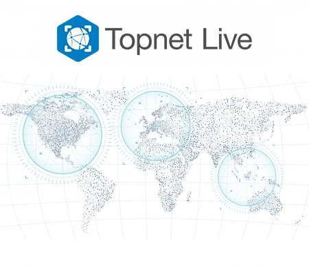
Topnet Live coverage map for 2021. (Image: Topcon)
Topcon Positioning Group has expanded its Topnet Live GNSS network of correction solutions with more types of correction services and subscription options. According to Topcon, the growth is a result of the increasing demand for digitalization in various industries including construction, surveying, machine control and agriculture.
Flexible service options include Realpoint, the real-time kinematic (RTK) service, and Starpoint, a Precise Point Positioning (PPP) service. The different services have varying delivery methods, coverage and reliable centimeter-level accuracy.
Under a flexible subscription model, customers can purchase to suit their needs. An RTK service supported by precise point positioning (PPP), Skybridge, is available to maintain connectivity and productivity if the customer temporarily leaves RTK coverage.
Topnet Live uses all four GNSS constellations — GPS, GLONASS, Galileo and BeiDou — to provide continuous accuracy and always-on service coverage. The service provides advantages for these industries:
Survey, Construction and Machine Control. Topnet Live removes the need for individual base stations, dramatically increasing flexibility, productivity and safety, and can drive large-scale projects with constant, reliable accuracy.
Precision Agriculture. The solution delivers fast, consistent, accurate positioning at any time day or night for soil preparation, seeding, spreading, spraying and harvesting.
OEMs, System Integrators, Product Designers. The solution provides scalable precise positioning and supports the implementation of flexible business models tailored to fit both OEMs’ and their customers’ needs.
“The Topnet Live RTK network, first established over a decade ago, continues to grow, with 5,100 reference stations globally, a 14% increase in the last year,” said Ian Stilgoe, Topcon vice president. “We are growing throughout the world in areas where there is an increasing demand for productivity and accuracy through digitalization, with strong growth particularly in North America and Europe. We are focused on continued expansion to maximize support for our customers, so they always have the best options globally.”
Original equipment manufacturers (OEMs) supplying automotive, industrial internet of things (IoT), autonomous robotics and all sectors that require positioning, navigation and guidance also benefit from the enhanced robustness of the network, Topcon said. OEMs can sell their hardware with correction services onboard and preconfigured for immediate use by customers, regardless of geographic location, with flexible subscription and licensing options to suit exact needs.
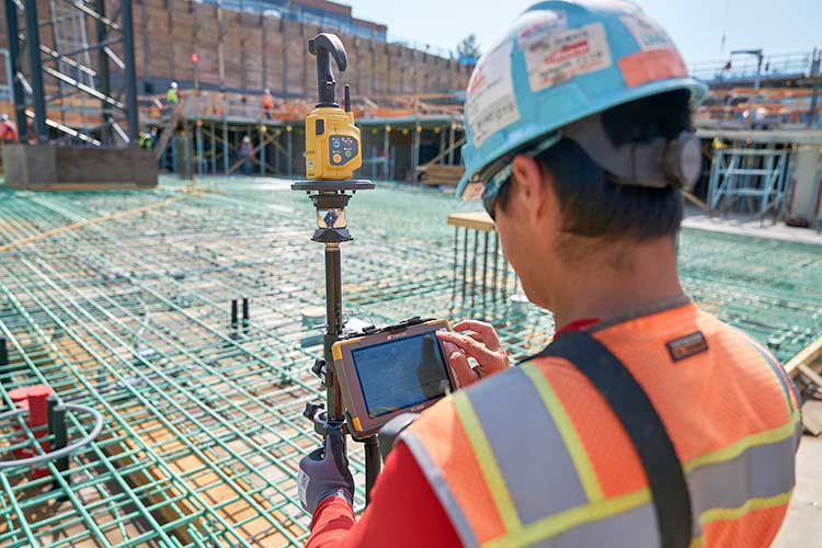
Topcon Positioning Group has released Topcon Point Manager, a point creation software that’s available as a plug-in for Autodesk AutoCAD and Autodesk Revit users in the U.S. and Canada.
According to Topcon, the solution is designed to automate point creation and easily import and export layout files to and from a robotic total station. It’ll also simplify the BIM-to-field process with a faster, more seamless point creation experience from within the design platform, reducing the time and cost of layout, Topcon added.
“Unlike standalone point creation software, which requires the user to leave their particular design environment, users of these two widely used Autodesk technologies will be able to access the solution as a plug-in component to their design package,” said Ray Kerwin, director of Topcon global product planning. “Users will benefit from the ability to automatically create multiple points on BIM objects and 2D/3D drawings from within the Autodesk environments. Just as importantly, however, they will see an increase in their quality assurance and control efforts through easily generated point and deviation reports; a likely reduction in on-site personnel (key during these challenging times), and, with the simplified processes, avoid costly construction errors and rework — the goal of most any operation working in today’s highly competitive construction environment.”
Photo: Topcon Positioning Group
In addition, Topcon MAGNET users can wirelessly send points to the field for layout and completed layout files can be sent back to the office to update the model to match as-built conditions.
“With the cloud-connected MAGNET workflow, BIM personnel or CAD teams can immediately share information to and from the field crew using a layout device. Doing so can prove invaluable, as any conflicts in point data can be quickly identified, keeping production levels up and eliminating costly rework,” Kerwin added.
Topcon Positioning Group designs, manufactures and distributes precision precision measurement and workflow solutions for the global construction, geospatial and agriculture markets.
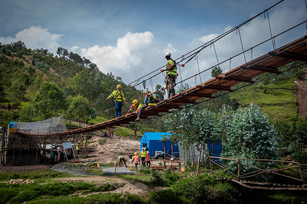
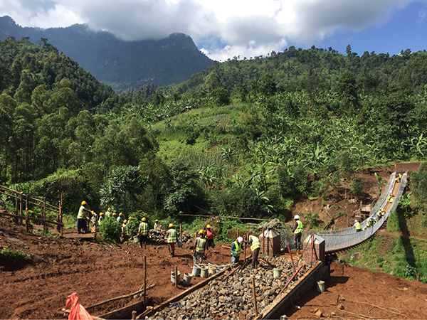
A shipping container with several pieces of key GNSS and survey instrumentation is bound for the East African country of Rwanda. The equipment, an in-kind donation from Topcon Positioning Group, will be used in support of Bridges to Prosperity (B2P), an organization committed to building trail bridges to improve the lives of people in rural areas worldwide.
Photo: Bridges to Prosperity
According to B2P, almost a billion people around the world lack safe access to critical resources like healthcare, education, or employment due to an impassable river. Building safe, structurally sound trail bridges for people to travel by foot, bicycle, or motorcycle has an immediate, impactful effect on the lives of those in the area.
“We are fortunate that, even with challenges presented by the COVID-19 pandemic, we have been able to implement new safety measures with limited disruption to our building schedule,” said Devin Connell, B2P’s corporate program director. “Right now, our surveying efforts predominantly involve simple equipment such as auto levels and range finders, which can be time consuming when complex survey information is needed. The equipment from Topcon will increase our surveying capabilities, streamline the design process, and support us in building more trail bridges for isolated communities.”
Photo: Bridges to Prosperity
In addition to the instruments — a pair of GNSS receivers, two total stations and data collectors — B2P will have access to the Topcon suite of software products, which will assist both the design process and the transfer of files from the field to their remote office or the engineering team working with them. According to Ron Oberlander, vice president of Topcon Global Professional Services group, however, the company’s role extends well past the equipment itself.
“We are excited to be a contributing part of this program,” he said. “But, in order for B2P to use these solutions to their fullest and increase their overall productivity, a training effort will be needed and we’re already setting plans in place for that to happen.
“In addition to conducting online virtual training sessions with B2P staff, we are making eLearning possible by allowing access to MyTopcon, our company knowledge portal. With these tools, they can gain familiarity with their receiver or total station or use the Topcon software to learn how to collect points — all without having us there. They want to be able to hit the ground running once the equipment arrives and this will help make that happen.”
Connell said that their improved survey capability will help accelerate the company’s bridge building. “We go out and survey a year in advance, looking at as many as 100 different remote sites and, tough as it might be, establish priorities with the local governments. We are looking forward to our continued growth in 2021 and, thanks to the generosity of companies like Topcon, that process will be a much better one.”
Social distancing and stay-at-home orders are affecting every sector of our economy. How are companies in our industry rising to this enormous challenge? What are they doing to keep their staffs, customers, and communities safe and to help slow down the spread of the pandemic? What are they learning in the process?
We asked our marketing partners, Editorial Advisory Board members and “Innovation” Editor Richard Langley the questions below so that we could share their collective wisdom with you, our readers. The advertisers’ responses appear in alphabetical order by company, followed by the responses by EAB members.
We will continue to publish these responses here as we receive them; we will also publish a selection of them in the May print issue of GPS World.
Professor, Department of Geodesy and Geomatics Engineering,
University of New Brunswick, Fredericton, Canada
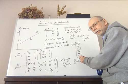
“Innovation” Editor and UNB Professor Richard Langley lectures to his students online. (Screenshot: Richard Langley/UNB)
On March 13, the president of the University of New Brunswick announced that as of the following day due to the Coronavirus-19 outbreak in the province of New Brunswick, all in-person classes would be suspended for the remained of the school term, and that starting March 23, classes would resume using alternative methods to support delivery outside the classroom. Faculty members like me had a week to find other ways to deliver our courses to the students. Some of us turned to pre-recorded video presentations and some, like me, to live class sessions using online video conferencing tools like Zoom and Microsoft Teams. I tried both but ended up using Teams on the advice of the university administration.
This term I was teaching GGE 3111: Introduction to Adjustment Calculus. Basically, it’s an introductory course on the mathematical technique of least-squares analysis. Least squares, where one seeks to find the minimum of the sum of the squares of the estimated errors in measurements, is a fundamental technique for analyzing data in many application areas in the sciences and engineering disciplines, including the processing of GNSS data. It was pioneered back in the early 1800s by Gauss, the great German mathematician and father of modern geodesy.
Incidentally, Kalman filtering also widely used for processing GNSS data, is essentially a recursive approach to the least-squares problem. The example I am doing on the board (see screenshot) is how to fit a straight line to data pairs x and y where both the x and y values contain random measurement errors. I have always taught GGE 3111 using the blackboard or, since lecturing from the dining room of my house by video link, a whiteboard.
I recorded my home-delivered lectures and provided these to the students through the Desire to Learn platform that UNB uses for teaching. Not all of the students could attend the live lectures as some had returned home to provinces with several hour time differences from New Brunswick making it inconvenient to attend a morning lecture. Others no longer had a good Internet connection to view real-time video.
The recordings also provided a useful resource to the students for reviewing the course material. When we eventually return to normality, I might continue to record my lectures. They could even form the basis of an online version of my course available to UNB students and non-students alike.
CAST Navigation has overcome many obstacles and challenges to be able to provide our customers with the products and services that are valuable to them during this difficult period. The company has instituted a set of strict policies and procedures that allow us to manage our facility hours and employee “distancing” practices.
We have also enabled employees to work remotely if necessary and we continue to work very closely with our vendor supply chain to minimize delays and impacts to our schedule. These policies and procedures, along with a very focused and devoted staff, have allowed us to continue to provide the superior quality products and services on which our customers rely.
Eos Positioning Systems’ employees are able to work remotely in most cases. In fact, prior to the pandemic, a number of full-time employees worked remotely across Canada, the United States, and the Asia/Pacific region. Now, we’ve transitioned all employees to remote working and transitioned the tasks of individuals whose routine work was directly affected by the virus. We’ve also added a weekly all-staff video Zoom meeting to address everything from company questions to individual wellbeing.
We were already grateful for our ecosystem of staff, partners, and customers, but everyone has shown their positive colors even more in response to this pandemic. Everyone remains responsive across platforms and time zones. The uptick in social media engagements of our customers and partners has been particularly great to see.
In addition, we’ve heard from some customers that they are using our GNSS receivers more during this time. Because our receivers are easy to use for the novice, office workers who would typically not do fieldwork are being trained on field work, which can be a naturally socially distanced, one-person job.
As expected, many of the events we enjoy sponsoring have been postponed or canceled. We’re working with event coordinators and our own team to ensure that when events start up again, we are prepared to go back to business as usual. We are really, truly looking forward to seeing our customers, partners, and colleagues in person again!
At GeoNumerics, we are all OK, including our families. As we are an R&D-intensive company focused on algorithms, software, and consultancy, we are lucky these days. Furthermore, some of our employees —women with young children — were already teleworking most of the time. Therefore, it was easy to extend this to the rest of the company.
Since mid-March, everyone is at his/her place teleworking. This enables us to:
keep the company running
keep our employees busy like in “normal” days
protect our customers by meeting deadlines
protect the economy by not stopping the business
on a case-by-case basis, help our providers/partners who had to stop their business.
Internally, we share a “good morning” short communication via WhatsApp and a daily 20 minute “virtual coffee break” after lunch via Skype.
Miguel Amor, Chief Marketing Officer, Autonomy & Positioning Division
Editorial Advisory Board Member
Miguel Armor
COVID-19 is affecting everyone on a global scale, which means that we all must work together to limit the spread of the virus and protect the people at risk. At Hexagon, our priority is keeping our employees and customers safe, and we are following all guidelines and recommendations set up at national, regional and local levels to do so.
Through all of this, we recognize that our employees and our customers are relying on Hexagon more than ever. Rest assured that we are taking all necessary steps to protect our employees and to minimize risk to the supply of our products and our services to our customers.
At Hexagon | NovAtel, we believe our size, reach, and position not only provide great opportunities but also carry great responsibilities. We understand that the GNSS community in general is relying on NovAtel more than ever and we are taking all the necessary steps to support the community and our customers.
Just like many of you, we at JAVAD GNSS are quickly and actively adapting to the changing times caused by the global COVID-19 pandemic. We recognize that JAVAD plays an important role in many of your operations and in supporting the critical missions of our customers. To that end, we are following best practices to curtail the spread of this virus and protect the well-being of our employees and partners, while ensuring we meet the commitments to you that you have come to expect.
Our primary message today is JAVAD GNSS is Open for Business! Our support team is here and ready to assist you as it always has. Please do not hesitate to contact us.
While there was a short pause in March when news broke in the U.S. about COVID, much of this now seems to be subsiding. At the same time, the value for instantly accessible aerial maps is more obvious than it ever was. As teams work from home and push to keep projects on track, the need for remote access to aerial photography remains strong at a time when travel and remote site inspection is lower than it ordinarily would be. Judging from very recent activity (all April 2020), there’s high interest from city government, engineering, construction, solar/energy and land development.
For Orolia, this crisis has highlighted the importance of the word “resilient.” As a leader in resilient positioning, navigation and timing (PNT) and as an essential business, we need a resilient organization that can keep delivering the critical solutions that our customers need. We can’t let our customers down because they support defense and critical infrastructure programs worldwide. Now more than ever, we recognize the essential nature of what we provide, and we must keep supporting our customers, even in times like this.
Orolia plays an essential role in the Defense Industrial Base (DIB) in the Critical Infrastructure Sector, as defined in the Department of Homeland Security (DHS) Memorandum on Identification of Essential Critical Infrastructure Workers During COVID-19 Response and the DHS Guidance on the Essential Critical Infrastructure Workforce: Ensuring Community and National Resilience in COVID-19 Response.
Many global companies need to continue operating as normally as possible to provide much needed capabilities in order to help governments, members of the armed forces and critical infrastructure to stay operational.
Our Supply Chain/Sourcing team conducts regular risk assessments to ensure that Orolia partners can continue to provide uninterrupted service by securing materials and products. Our service, support, business development. and engineering teams also remain ready to respond to requests.
We use Skype extensively, to keep in touch with our customers and partners but also for internal conference calls and meetings. There isn’t really a substitute for face-to-face meetings, but Skype is as close as you can get. In terms of communicating with our partners we have very much moved into the digital space. We have instead held webinars using WebEx which have been very well received. We have more planned so watch this space!
We have learned that we can work very well under pressure! With COVID-19 postponing some of our favorite shows we didn’t want to sit back and do nothing. We had to act very quickly and look at other ways of communicating our message. Not only have we as a business been agile enough to do this, despite working remotely, our channel partners have really taken on board what we’ve been trying to achieve and helped us exceed our goals.
Don’t use COVID-19 as an excuse to rest on your laurels. Take it as an opportunity to do some of the things that you otherwise wouldn’t have done.
To collaborate remotely, a safe distance from each other, we use video messaging (MS Teams) with team(s) daily, as well as Confluence (engineering documentation) and Jira (task management) for remote collaboration.
Much of our team is able to continue efficient operations while working remotely. Collaborating with our customers has always been a service we offer – which, we believe, leads to better product performance and reliability. This pandemic has pushed the majority of the country/world into remote working. While we aren’t able to be in person with customers, accessible remote tools and collaboration help us continue to provide hands-on customer service, without actually using our hands.
Parker LORD designs and produces MicroStrain inertial sensors that are used in robots that aid in delivery, mapping, and surveillance activities. Our inertial measurement units (IMU) and inertial navigation systems (INS) are designed to allow quick time-to-market development. We offer IMU/INS integration with our recently updated Robot Operating System (ROS) drivers for ease of use. By using our sensors, we have reduced development time while also offering top performance and competitive pricing. There are different levels of inertial sensors based on the performances available depending on the application being used.
As the need for measurement and navigation solutions increase with the demand for delivery, safety and automated robotic monitoring, our new 3DMGQ7-GNSS/INS dual antenna RTK-enabled INS provides next level performance with integrated custom IMU, dual integrated RTK-capable multi-constellation GNSS receivers, integrated barometric pressure sensor, and magnetometer. Beyond the integrated sensors the GQ7 offers hardware support for wheel odometry and API support for external velocity sensor measurements. This sensor has been designed for use in markets such as beyond visual line of sight (BVLOS) unmanned aerial vehicles (UAV), unmanned vehicle navigation, legged robots, and autonomous vehicles. It’s an all-in-one system solution (GNSS-INS + RTK + SensorCloud RTK).
Get ready for the robot revolution. There was momentum in that direction before, in areas such as delivery, recon and mapping. Acceptance of these technologies will only increase now and in the future.
Racelogic, the company behind LabSat GNSS simulators, is based in Buckingham, UK. Like many companies, we are adjusting to new ways of working and remote collaboration. With the majority of our 100 staff now working from home, I have few concerns about their ability to adapt and am confident that the outcome will be one of success. However, I am also aware that the paths taken over the coming weeks or months are unlikely to be without a few bumps in the road.
I am hearing reports from all corners of Racelogic about how staff are dealing with these unprecedented circumstances. For example, Katie Harland, our LabSat Support and Applications Technician, is continuing to support our customers from home. However, without a rooftop antenna on her building she has had to be a little inventive about how she gains a live satellite feed to record test scenarios. Her solution was to mount an antenna on a ground plate devised from the lid of a biscuit tin and set it on her garden wall. An effective solution, but one that is not straight forward when you are 5’2” and the garden wall is 7’ tall.
I am also noticing changes to what a “normal” day at work now looks like. With so many staff working remotely I find myself walking through the office and instead of checking on project progress I am rebooting computers, connecting equipment, accessing server files, and generally servicing those who are working remotely. I think it is easy to fall into the trap of obsessing about perfecting remote working. I don’t think you can go too far wrong if you focus on the things you can do, even if you need a ladder to get there.
During these challenging times, Septentrio continues to be operational and to serve its customers. We have taken measures to ensure health and safety within the company. Most of my colleagues and I are working from home, while manufacturing has been divided into two shifts to guarantee continuity and provide the safest possible working conditions. Although international travel is suspended for the moment, we continue to have regular meetings via phone or web with our partners, customers and prospective clients.
This virus is forcing us to rethink the way we work and interact. As we adjust to the new situation, we are finding ways to continue working with as little disruption as possible, leveraging the efficient communication networks and remote-control solutions available to us today. Along the way we might even discover new more efficient and environmentally friendly ways of working.
In addition to ensuring employee safety, Septentrio is also dedicated to help fight the virus by providing reliable high-accuracy positioning solutions to technologies that are making a difference. For example, aerial drones have been used by police in Europe to announce new government regulations in public places and to scope out large areas for public gatherings. To ensure public safety it is vital that the sensors aboard these aerial drones, such as their positioning receivers, are robust and reliable even in challenging conditions.
Other delivery drones such as Zipline and Wing are expected to ramp up speed with the increase of automation required to fight the coronavirus. In the European Union and the United States regulations around drone use are stricter than in China and thus the full potential of drones is not yet realized to its maximum.
Since our inception, a few of our employees have worked from home due to traffic issues, work/home responsibilities, or simply geographical location issues. Over the years, we decided as a company not only that this was working very well, but that everyone who could work from home should be allowed to have the same privileges. In the past two years, we have allowed everyone to work from home, only requiring to come into the company offices those who must be in a lab or for security reasons. Everyone has a laptop computer and remote access to files. We use Zoom, email, and cell phones to communicate with each other and our customers.
When the recommendations from the CDC and the President of the United States were issued to work from home, we were already doing this, so there were no adjustments needed. Those that must work in the lab are practicing social distancing and working on alternate days in some cases.
When we first contacted our customers to attempt visits, we were told that they were not receiving visitors and that it was going to take a few days or weeks to get everyone outfitted with laptops and other technology to continue working from home. We were a bit surprised to learn that others were going through this as we were not having any of these issues.
This crisis has taught us that being prepared and trusting our team to work independently pays off when we really need it. Everyone is being a little extra patient, kind, and understanding. We are seeing this general compassion outside of the office as well and we hope that this has a lasting effect on the world.
Jackie Ferreira, Director of Corporate Communications
Jackie Ferreira, Topcon
We are fortunate in that our team is well-versed in online collaboration software, including teleconferencing and online digital asset management systems. We are leveraging tools such as those to keep productive in this crisis.
We are working very well together via safe distancing practices. Our employees around the world are staying active with ongoing conference calls across multiple time zones. Our primary concern is the health and safety of everyone we interact with and we continue to be impressed with how all involved have responded.
Topcon operates with a primary goal of the health and safety of its employees, customers, and suppliers and in accordance with applicable state and local orders, including social distancing requirements. To this end, we provide on-going guidance from the World Health Organization (WHO) and Center for Disease Control (CDC) to our employees to support their health in these critical times.
We encourage compliance with applicable governmental orders concerning their ability to continue to operate, with the understanding of roles within the critical infrastructure supply chain.
We are dedicated to supporting our customers at this critical time and have specific teams working to meet demands to the best of our ability.
Our relationships with our customers and partners are important to us. Topcon strives to work closely together with our partners to protect the industries we serve and accelerate the economic recovery needed in light of the current world crisis. Together we can serve as a beacon of cooperation and commitment to successfully weather these unusual times.
The outbreak of COVID-19 started around the Spring Festival, and strict control measures to stop the spread of the virus were taken even before the holiday ended. Unicore postponed the return-to-job date by one week and encouraged working from home, except for the key R&D and ST engineers, who cannot perform verification, testing, or debugging outside the labs. However, even then strict social distancing measures were guaranteed. As of February 10, Unicore’s return-to-work rate was more than 80%, with nearly 40% of the employees doing it from the office, while now nearly 90% of Unicore’s labor force is back to normal working mode. Thanks to the 4G networks, fast mobile and Web communications, as well as cloud computing technologies, we were able to easily organize video conferencing, online meetings and group messaging.
Our R&D and product delivery were slightly affected by the COVID-19 due to the delays at some supply plants. However, Unicore has a well-run and organized inventory management system, so most of the orders can be fulfilled on time.
Some of Unicore’s clients use drones to perform disinfectant spraying and logistics transportation, which help to ensure an uninterrupted supply of food and goods. Other clients make intelligent and autonomous sweepers that reduce the need for manual labor and keep the workers safely at home. In order to avoid personal injury, infection and transmission in epidemic areas, drones and/or unmanned vehicles with GNSS high-precision positioning technology have been used for cleaning and disinfection, supplies delivery, and aerial photography in engineering construction.
Topcon Positioning Group displayed its GTL-1000 scanner at Intergeo 2019, which took place Sept. 17-19 in Stuttgart, Germany. According to the company, the GTL-1000 is a compact scanner integrated with a fully featured robotic total station, enabling a site engineer to complete a layout and scan on a single setup.
Topcon Positioning Group will be showcasing its vertical construction, construction management, and structural health and inspection technology at Intergeo 2019. (Photo: Topcon)
Topcon Positioning Group will be demonstrating its technology offerings across vertical construction, construction management, and structural health and inspection at Intergeo 2019.
Topcon will present its new building information modeling (BIM) technology at the show, which includes the Topcon vertical construction workflow. The Topcon vertical construction work flow includes the Laser Scanning Robotic Total Station GTL-1000, MAGNET Collage and ClearEdge3D Verity software.
According to the company, the full workflow is designed to offer a powerful instrument for single-operator layout and scan on a single set up. It will also be releasing new innovative digital layout solutions alongside the GTL-1000 to enhance the VC portfolio and widen the options available to customers for this critical task.
Topcon will also be showcasing its inspection, assessment and monitoring solutions, which are designed to keep infrastructure assets in operation by providing reporting tools for site engineers and monitoring structural health.
Topcon added that it will be demonstrating its GTL-1000 and accompanying software MAGNET and ClearEdge3D Verity at the show. Its booth will also feature interactive displays that will provide virtual looks at job sites.
“Productivity is a huge talking point in our industry, so this year at Intergeo we’re proving that Topcon is always one step ahead, working in partnership with the construction and infrastructure sectors to provide solutions and products to address the big issues,” said Ian Stilgoe, vice president of Geopositioning Europe at Topcon Positioning Group. “Whether it’s quicker, simpler verification, or smart inspection and monitoring of aging assets, the need for digital innovation is greater than ever.”
Topcon’s demonstrations will be taking place at its booth, F3.013, in hall 3.
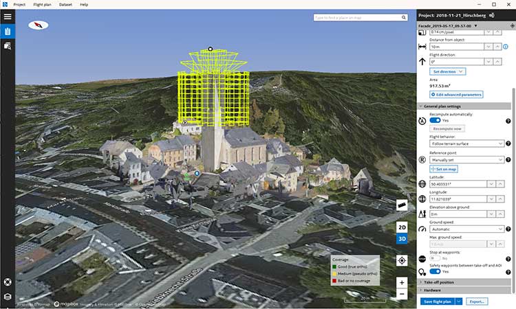
Topcon Positioning Group has released its next-generation flight-planning system for its rotary-wing aerial UAV offering.
The new Intel Mission Control Software is designed to facilitate automated flight planning, managing missions and data handling for the Intel Falcon 8+ drone – Topcon Edition and its available payload options.
The software is designed to increase accuracy with advanced mapping features that allow operators to easily set project parameters and prepare missions using presets for 2D areas such as polygon, corridor and city grid, as well as 3D structures like towers, buildings and facades.
“Operators can take advantage of 2D and 3D map views with the ability to import more precise project details and parameters, including restricted airspace, and support to adapt flight planning over difficult terrain,” said Charles Rihner, vice president of planning for Topcon Emerging Business.
“It features the ability to import elevation, KML, GeoTIFF and Shapefiles for real life visualizations targeted for accurate planning. Plus, expanded preset options support automated flight including circle of interest, panorama, and 2D and 3D missions with automatic elevation and terrain adoption,” Rihner said.
Additionally, the software includes automatic pre-flight safety and system checks while in mission planning. “Operators will receive detailed communication such as estimated battery life, airspace integration, ground and object safety limits, maximum dive and climb rate, minimum and maximum altitude, camera speed, number of images, camera storage, GSD check, and target photo coverage and quality,” Rihner said.
The flight-planning software is also designed to improve data handling and export to support easier data processing.
“It includes automated image matching and geotagging of images during data import, for increased time saving. Operators can preview and inspect the quality of the collected data, including individual images, as well as an overview of data coverage. Then, they can quickly and easily access and export flight data, and filter datasets for easier processing,” Rihner said.
Topcon Positioning Group’s Raymond Dimas discusses the company’s HiPer VR GNSS receiver at Intergeo 2018 in Frankfurt, Germany. According to the company, the HiPer VR is a complete solution can can be used for static or kinematic GNSS post-processed surveys, as a network RTK rover with the FC-5000’s internal 4G/LTE cellular modem and as a UHF/FH/Longlink jobsite RTK rover.
MAGNET Collage Web version 1.3 is designed to allow operators to work with more types of data with greater flexibility, including the ability to import BIM models, as well as CAD and GIS data, the company said.
MAGNET Collage Web and MAGNET Collage desktop software meet the demands of a diverse user-group. The latest update is designed to address an increasing need from the vertical building construction market segment to work in a single-software environment with BIM, scanning, and UAV datasets.
“Now operators can view and publish BIM models, along with other data types, directly through the web browser to be sharable with more versatility,” said Alok Srivastava, director of product management. “MAGNET Collage Web can be used to overlay as-built laser scans and design data to visualize proposed changes and detect construction issues. The software supports OBJ, FBX and 3DS formats.”
The upgrade to MAGNET Collage Web also includes new direct publishing functionality for CAD and GIS data files through the browser.
“Operators can now overlay 3D point clouds and reality models with CAD and GIS design data, including support for DXF, SHP, KML, GML and GeoJSON formats,” said Srivastava.
The upgrade to MAGNET Collage Web also introduces advanced sharing controls including the ability to fully customize layer visibility, appearance, window layout, feature selection, and camera position.
“The updated customization controls allow operators to share and present their projects exactly the way they mean to with a multitude of viewing options, allowing specific features to be highlighted as necessary,” said Srivastava.
Additionally, MAGNET Collage Web can now be accessed through the Topcon “Blue Bar” that allows direct access to the service from any Topcon website. The universal account and application management toolbar is embedded at the top of Topcon web pages.