Tag: total electron content

  • PlanetiQ wins largest-ever NOAA contract to provide GNSS-RO weather data

    PlanetiQ wins largest-ever NOAA contract to provide GNSS-RO weather data

    PlanetiQ, a provider of commercial weather and space weather data, has been awarded a $24.3 million contract from NOAA’s National Environmental Satellite, Data, and Information Service (NESDIS). The award, issued under the Commercial Data Program’s Radio Occultation Data Buy 2 (RODB-2), is NOAA’s single largest commercial satellite weather data purchase.

    Under the agreement, PlanetiQ will deliver 7,000 GNSS-RO profiles per day, including 500 enhanced high-signal-to-noise ratio (SNR) profiles as well as 2,500 low-latency Total Electron Content (TEC) tracks daily. Data deliveries began Sept. 18.

    “I founded PlanetiQ because radio occultation is one of the few technologies I’ve worked with that tangibly improves the human condition. It’s gratifying to see this capability recognized and scaled.”

    GNSS-RO data from PlanetiQ provides precise vertical profiles of the atmosphere across the globe, over land and sea, and in cloudy and clear conditions. It is recognized as the most impactful satellite data input for weather forecast models. GNSS-RO has become critical to space-based climate monitoring, improving and stabilizing weather prediction and atmospheric research over the past several decades.

    The 500 enhanced high-SNR profiles per day are especially valuable in the lower troposphere, where measurement and forecast accuracy are often most challenging, further enabling actionable decisions and operations planning with reduced risk.

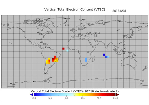
    TEC data additionally strengthens NOAA’s space weather monitoring and forecasting capabilities.

    “This award demonstrates NOAA’s confidence in our ability to deliver both the quantity and quality of data needed to advance weather and space weather forecasting,” said Ira Scharf, chief executive officer of PlanetiQ. “We are proud to expand our support for NOAA and its mission to protect life and property.”

    The new contract represents a threefold increase in PlanetiQ’s data deliveries compared to its most recent NOAA award, which provided 2,200 profiles per day, and is adding the enhanced SNR and TEC tracks as new products. PlanetiQ collects thousands of profiles daily across the planet and plans to expand its constellation of satellites in the future.

    PlanetiQ is excited that organizations running numerical weather prediction, and especially AI forecast models, are recognizing the value in high-quality GNSS-RO data. “Our ability to provide enhanced high-SNR profiles, at seven times the SNR of any other commercial company, sets us apart,” said Chris McCormick, president and chairman of PlanetiQ. “I founded PlanetiQ because radio occultation is one of the few technologies I’ve worked with that tangibly improves the human condition. It’s gratifying to see this capability recognized and scaled.”

    While NOAA is the procuring agency of the GNSS-RO data, it will also be used by NASA, the U.S. Air Force, the U.S. Navy, and international government weather agencies for operational and research purposes.

    This award underscores the critical role of public-private partnerships to bring new capabilities online faster and at a lower cost to strengthen national forecasting and research. PlanetiQ also partners with leading commercial technology companies and data providers.

  • NOAA, Los Alamos release new data on ionosphere for PNT

    NOAA, Los Alamos release new data on ionosphere for PNT

    A new data source to help scientists better understand the ionosphere and its potential impact on communications and positioning, navigation and timing (PNT) is now available to the public.

    The data, which was collected by sensors on GPS satellites in 2018, was released through a collaborative effort by Los Alamos National Laboratory and the National Oceanic and Atmospheric Administration (NOAA).

    “Radio signals from satellite or ground-based transmitters can travel through the ionosphere or bounce off of it, so ionospheric conditions have the potential to disrupt communications depending on the density of electrons,” said Erin Lay, a remote-sensing scientist at Los Alamos who was a technical lead on the project. “This new set of data will help us better model and predict the behavior of the ionosphere and possibly improve the reliability of our communications and positioning, navigation, and timing services, which are critical for both everyday life and national security.”

    The ionosphere is the boundary between Earth’s atmosphere and space, stretching 40 to 250 miles above Earth’s surface. It is composed of tenuous atmosphere and charged particles (ions and electrons) that interact with traversing radio waves. The behavior of the ionosphere reacts to weather on Earth, such as thunderstorms, wind, and hurricanes, as well as space weather created by solar winds impacting Earth’s magnetic field.

    “NOAA’s Space Weather Prediction Center (SWPC) serves a huge customer base interested in space weather effects on communications and GPS-reliant technologies,” said Bill Murtagh, program coordinator at SWPC. “We expect access to these Los Alamos data sets to improve the development, validation, and testing of models used at SWPC for characterizing and forecasting ionospheric disturbances.”

    Preview graphic. (Image: NOAA)
    Preview graphic. (Image: NOAA)

    The new data comes from unique measurements of lightning events, each of which produces a flash of radio waves that gets dispersed through the ionosphere before it is detected on satellite receivers. Each measured flash provides a snapshot of the ionospheric conditions at that instant, and many lightning measurements accumulated over time provide a unique view of ionospheric weather. This is the first-ever global set of ionospheric electron density data to use a naturally occurring source phenomena.

    Before this release, the data available to feed ionosphere models was primarily from arrays of ground-based receivers, which are limited because they only monitor fixed locations. According to Lay, “the new data is gathered from lightning that happens all over the world and will give scientists the opportunity to study the ionosphere in ways previously not possible.”

    The release of underutilized data sets was a priority established in the 2019 National Space Weather Strategy and Action Plan. Los Alamos processed the data from its radio-frequency sensors that are onboard GPS satellites and used for nuclear treaty monitoring, and then worked with a government interagency group, called the Space Weather Operations, Research and Mitigation (SWORM), to facilitate public release.

    NOAA’s National Centers for Environmental Information will host the data on existing sites that serve terrestrial weather and space weather resources.

    The ionosphere is shown in purple and not-to-scale in this image. (Image: NASA’s Goddard Space Flight Center/Duberstein)
    The ionosphere is shown in purple and not-to-scale in this image. (Image: NASA’s Goddard Space Flight Center/Duberstein)

  • GNSS data show Lebanon blast affected ionosphere

    GNSS data show Lebanon blast affected ionosphere

    A 2020 explosion in Lebanon’s port city of Beirut led to a southward-bound, high-velocity atmospheric wave that rivaled ones generated by volcanic eruptions.

    The epicenter in Beirut, before and after the explosion.(Image: Bhaskar Kundu, et al. Scientific Reports. Feb. 2, 2021).
    The epicenter in Beirut, before and after the explosion.(Image: Bhaskar Kundu, et al. Scientific Reports. Feb. 2, 2021).

    Just after 6 p.m. local time (15:00 UTC) on Aug. 4, 2020, more than 2,750 tons worth of unsafely stored ammonium nitrate exploded in Lebanon’s port city of Beirut, killing around 200 people, making more than 300,000 temporarily homeless, and leaving a 140-meter-diameter crater in its wake. The blast is considered one of the most powerful non-nuclear, man-made explosions in human history.

    Now, calculations by Hokkaido University scientists in Japan have found that the atmospheric wave from the blast led to electron disturbances high in Earth’s upper atmosphere. They published their findings in the journal Scientific Reports.

    The team of scientists, which included colleagues from the National Institute of Technology Rourkela in India, calculated changes in total electron content in Earth’s ionosphere: the part of the atmosphere from around 50 to 965 kilometres in altitude. Natural events like extreme ultraviolet radiation and geomagnetic storms, and man-made activities like nuclear tests, can cause disturbances to the ionosphere’s electron content.

    “We found that the blast generated a wave that travelled in the ionosphere in a southwards direction at a velocity of around 0.8 kilometres per second,” says Hokkaido University Earth and Planetary scientist Kosuke Heki. This is similar to the speed of sound waves travelling through the ionosphere.

    The team calculated changes in ionospheric electron content by looking at differences in delays experienced by microwave signals transmitted by GPS satellites to their ground stations. Changes in electron content affect these signals as they pass through the ionosphere and must be regularly taken into consideration to accurately measure GPS positions.

    The ionospheric disturbance caused by an explosion can be detected by differential ionospheric delays of microwave signals of two carrier frequencies from global navigation satellite system (GNSS) satellites. (Image: Bhaskar Kundu, et al. Scientific Reports. Feb. 2, 2021).
    The ionospheric disturbance caused by an explosion can be detected by differential ionospheric delays of microwave signals of two carrier frequencies from global navigation satellite system (GNSS) satellites. (Image: Bhaskar Kundu, et al. Scientific Reports. Feb. 2, 2021).

    The scientists also compared the magnitude of the ionospheric wave generated by the Beirut blast to similar waves following natural and anthropogenic events. They found that the wave generated by the Beirut blast was slightly larger than a wave generated by the 2004 eruption of Asama Volcano in central Japan, and comparable to ones that followed other recent eruptions on Japanese islands.

    The energy of the ionospheric wave generated by the Beirut blast was significantly larger than a more energetic explosion in a Wyoming coal mine in the USA in 1996. The Beirut blast was equivalent to an explosion of 1.1 kilotons of TNT, while the Wyoming explosion was equivalent to 1.5 kilotons of TNT. The total electron content disturbance of the Wyoming explosion was only 1/10 of that caused by the Beirut blast. The scientists believe this was partially due to the Wyoming mine being located in a somewhat protected pit.

    Original Article

    Bhaskar Kundu et al. Atmospheric wave energy of the 2020 August 4 explosion in Beirut, Lebanon, from ionospheric disturbances. Scientific Reports. February 2, 2021. DOI: 10.1038/s41598-021-82355-5