Over the last few weeks, many organizations have transitioned their workforce to remote work environments. At the same time, the demand for geographic information systems (GIS) products and skilled GIS professionals is high.
Esri announces that all of its instructor-led courses are available in its instructor-led online classroom, which is calls “an engaging learning environment that offers convenience and interactivity.”
The company lists these features:
Instructors and course attendees use the phone, chat, and virtual whiteboards to talk and collaborate in real time.
Group breakout sessions and content reviews support peer-to-peer learning and knowledge retention.
Attendees access all Esri software needed to complete course exercises through virtual machines.
“We understand that sustaining business operations and achieving your organization’s mission remains critical,” the Esri Training Team said in an email. “As always, we’re committed to helping you build the skills needed to apply ArcGIS best practices, fuel efficiencies and make the best decisions based on data.”
Esri offers the Esri Training Pass to streamline access to its online instructor-led classes. Users can pre-purchase training days to simplify training registration and approval processes throughout the year.
Course takes learners on a deep dive into concepts and applications
Esri logo
Esri will offer a new massive open online course (MOOC) on spatial data science early this year. The no-cost course, which will run for six weeks on Esri’s Training website, includes full access to ArcGIS Pro, ArcGIS Online and ArcGIS Notebooks software.
Spatial Data Science: The New Frontier in Analytics opens on Feb. 26 and provides a comprehensive introduction to how incorporating location enhances traditional data science workflows.
“Spatial data science builds on foundational data science techniques and adds the spatial perspective that really makes a huge difference in the outcomes of an analysis,” said Lauren Bennett, software development lead on Esri’s spatial analysis and data science team.
The course includes video presentations by Esri experts, discussion forums, and hands-on software exercises. Participants will discover how including spatial data and spatial analysis tools and techniques can dramatically improve predictive modeling, uncover previously hidden patterns, and solve problems.
“At its core, spatial data science is about solving problems,” Bennett continued, “using spatial algorithms, taking the latest and greatest techniques (statistics, machine learning, deep learning) and all the tried and true, more traditional techniques to turn data into information.”
Each section of the course will focus on a specific topic and application of spatial data science. From data engineering and visualization to suitability modeling, pattern detection, space-time pattern mining, and object detection with deep learning, participants will explore a wide range of scenarios using realistic data and powerful ArcGIS tools.
While many practitioners emphasize craft when sharing results, course authors champion the notion that successful analysts and data scientists must be able to effectively communicate the impact of their work with leaders and colleagues. For this reason, the final section of the course will explore the use of ArcGIS StoryMaps to craft visually appealing and information-rich narratives that resonate.
Spatial Data Science: The New Frontier in Analytics is open to learners worldwide. All that’s needed to attend is an Esri account, which is free and easy to create at accounts.esri.com.
Participants with a background in statistics, data science and Python are encouraged to attend, but anyone interested in exploring technology hot topics and learning the latest analytical capabilities of ArcGIS software will benefit as well. A certificate of completion will be awarded to all participants who finish the course.
NavtechGPS is offering the following multi-day training sessions on GNSS/GPS technology in New Orleans this December. Both courses will take place at the InterContinental New Orleans Hotel.
Take this 4-day course to gain a comprehensive understanding of GPS/GNSS system concepts, design and operation, including information on GPS signal processing by the receiver; techniques by which GPS obtains position, velocity and time and a brief introduction to differential GPS (DGPS) and Kalman filtering.
Expanded to a full five full days based on attendee requests, this course on GPS-aided navigation will thoroughly immerse you in the fundamental concepts and practical implementations of the various types of Kalman filters that optimally fuse GPS receiver measurements with a strapdown inertial navigation solution. The course includes the fundamentals of inertial navigation, inertial instrument technologies, technology surveys and trends, integration architectures, practical Kalman filter design techniques, case studies, and illustrative demonstrations using MATLAB.
Five fulls days allow for a fuller and detailed development of the design of an aided navigation system, combined with a detailed discussion of the use of lower quality IMUs, and advanced filtering techniques.
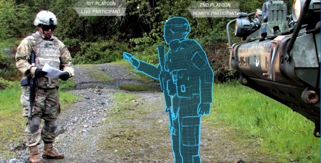
The U.S. Army considers virtual reality training as an important path ahead to prepare warfighters.
The U.S. Army awarded Bohemia Interactive Simulations (BISim) a major extension to demonstrate technologies for a cloud-enabled, virtual world training capability.
BISim is a global developer of advanced military training and simulation software.
The contract award helps meet the requirements of the Army’s Synthetic Training Environment (STE) initiative. STE aims to converge virtual, constructive and gaming training environments into a single unified architecture.
The ambitious STE project will enable simulation systems Army-wide to leverage a persistent virtual world for any imaginable training need, including support for multi-domain operations incorporating cyber and space.
Central to STE is a cloud-enabled One World Terrain (OWT) that will let warfighters conduct virtual training and complex simulations anywhere on a virtual representation of the Earth. OWT will leverage cloud technologies to deliver to the point of need, ensuring a common and high-fidelity whole-Earth terrain representation for a multitude of different simulation systems.
The Synthetic Training Environment will assess Soldiers in enhancing decision-making skills through an immersive environment. (Photo: U.S. Army)
“The U.S. Army’s vision for STE marks a monumental change in how they acquire, develop and deliver new simulation and virtual training technologies to soldiers,” said Pete Morrison, BISim’s co-CEO and chief product officer. “We’re honored to be selected to assist the Army in developing innovative solutions that will shape the future of how virtual training is used to enhance operational readiness.”
BISim has been developing its next generation of simulation technologies since 2014. The new technology suite includes a cutting-edge, military-specific whole-earth game engine, deterministic AI, an efficient geospatial terrain server and component-based development technology.
BISim technology underpins funded research and development for One World Terrain. Additionally, BISim recently demonstrated Reconfigurable Virtual Collective Trainer (RCVT) prototypes for STE. The latest OTA extension is a significant ramp up in the breadth and ambition of the technology being demonstrated.
BISim’s STE offering includes four core technologies uniquely suited to meeting future military simulation requirements (including U.S. Army requirements).
VBS Blue. A high-performance, whole-planet data ingestion and rendering engine with a very high level of procedural detail, designed to ingest any conceivable terrain data format as well as source data directly. VBS Blue will support networked (cloud) terrain paging and geo-specific insets as well as the latest graphics technologies. It provides photorealistic detail, and includes a massive vegetation library representing every region on Earth. The technology is highly applicable across all types of image generation and is optimized for many AR/VR applications.
STEWS. A geospatial data server that provides efficient networked access to the various data sources required for rendering applications. STEWS provides a curated database of terrain data layers that can be streamed into any STE-connected client application at run time (including non-BISim applications). Any application connected to STEWS can stream high fidelity terrain data in a performant manner. Both new and legacy terrain formats are supported through new STEWS plug-ins.
VBS Control. High fidelity, doctrinal and deterministic entity-level artificial intelligence that is uniquely suited to operation on whole-earth terrain. VBS Control runtime offers highly efficient real-time path planning that allows AI to move seamlessly through open, urban and interior spaces. The VBS Control Editor allows powerful new AI behaviors to be developed at both the individual entity level and at higher levels of command for land, sea and air assets.
Gears. A software development framework that defines a standard way for components to communicate through formal interfaces. Gears uses a component-based architecture to promote rapid development by building applications from self-contained systems and having them communicate via formally defined interfaces. This allows functionality to be reused and avoids the complexity of tightly coupled systems. See www.gears.studio for more information.
The Army also selected BISim for a five-year contract to support their Games for Training Program and BISim’s technology is being rolled out on CCTT (the U.S. Army’s largest ground simulator training program).
With ArcGIS for AutoCAD from Esri, AutoCAD users can access maps and data from Esri ArcGIS software for use in computer-aided design (CAD) drawings. This free application makes it simple for AutoCAD users to find, create and edit content stored in ArcGIS.
To learn how to work with the application, tune in to the live training seminar Simplify CAD-GIS Workflows Using ArcGIS for AutoCAD on March 10. In the seminar, you will learn how to easily create data, edit ArcGIS enterprise geodatabases, and leverage ArcGIS web services—without ever having to leave your familiar AutoCAD environment.
After viewing the seminar, you will understand how to
Easily edit GIS data using AutoCAD and ArcGIS for AutoCAD.
Access and interact with ArcGIS for Server web services inside AutoCAD.
Configure and customize ArcGIS for AutoCAD to meet the requirements of a production environment.
Use ArcGIS for Desktop, web, and mobile applications from within AutoCAD.
AutoCAD users who want to use CAD editing workflows to create and maintain GIS data stored in Esri ArcGIS will find this live training seminar highly useful. The seminar also will be of interest to engineers and designers who want to access data stored in ArcGIS to make more informed design decisions and to GIS professionals who want to streamline their CAD-GIS workflows and easily share data with coworkers or consultants.
You will need a broadband Internet connection and an Esri Account to watch the live training seminar. Creating an Esri Account is free: visit esri.com/lts, click Login at the top right, and register your name and email address.
GEOINT 2015 attendees have the opportunity to sign up for the GEOINT Foreword pre-conference session, earn Continuing Education Units in 80+ hours of training, be among the first to take Universal GEOINT Certification exams, and much more. The United States Geospatial Intelligence Foundation (USGIF) has once again expanded its dedicated professional development offerings at the GEOINT 2015 Symposium, to be held June 22-25 at the Walter E. Washington Convention Center in Washington, D.C.
GEOINT Foreword
GEOINT 2015 kicks off with GEOINT Foreword, a pre-symposium science and technology-focused day designed to highlight advances in GEOINT tradecraft and innovation. In addition to a keynote speaker, lightning talks, and networking breaks, GEOINT Foreword will host 14 panel sessions on topics such as: utilizing commercial space and SmallSat assets; data science acquisition models; modeling and simulation; open-source apps; interoperability; and more. GEOINT Foreword requires separate registration.
Training & Education
The GEOINT 2015 agenda offers more than 80 hours of training and education sessions, which have more than doubled since last year’s Symposium. Two-hour training and education sessions will be conducted in both the morning and afternoon June 23-25. Session topics include crisis mapping, full-motion video, LiDAR, game engines, spatial literacy, GEOINT 101, commercial electro-optical imagery, point cloud technology, cognitive computing, and more. To participate in training, attendees must add desired sessions to their GEOINT 2015 registration. Training and education sessions are accredited by the International Association for Continuing Education and Training. Attendees will receive 0.2 Continuing Education Units per session courtesy of USGIF Member Riverside Research.
Universal GEOINT Certification
This fall, USGIF will launch its Universal GEOINT Certification.Each of the three exams required to achieve the certification will require beta testers. Pilot versions of the GIS and remote sensing exams will be administered at GEOINT 2015. Qualified symposium attendees will have the opportunity to take one or both exams for free to count toward their Universal GEOINT Certification. Attendees can add pilot exams to their GEOINT 2015 registration or email [email protected] to learn more.
Family Day
The GEOINT Symposium will for the first time feature a family day June 25 from 12:30 to 3 p.m. Attendees are invited to bring their families to explore the exhibit hall and participate in fun, interactive activities. USGIF’s Young Professionals Group will host a ScavenGeo Dash in the exhibit hall from 1-3 p.m. The dash is an educational scavenger hunt offering families a unique opportunity to learn about the GEOINT Community through an exciting competition. To sign up for the ScavenGeo Dash, email [email protected] and include the names and ages of your team members. Teams should not exceed six members.
To learn more about these educational offerings, view the full symposium agenda, or to register for GEOINT 2015, visit geoint2015.com.
The sessions are aimed at GIS professionals, or those just starting a career that requires the use of GIS software training. All attendees who successfully complete the required courses will be recognized as a certified Global Mapperor Geographic Calculator user. For detailed information on the class content, see the register link below.
Washington, D.C., Area
Topics: Global Mapper, Applied Geodesy & the Geographic Calculator Registration Deadline: March 2, 2015 Dates: March 16-20, 2015 Time: 8 a.m. to 5 p.m. Location: Westfields Marriott Washington Dulles
14750 Conference Center Drive, Chantilly, VA 20151
Sign up Options: Sign up for one class or all four.
Cost
Length
Title
Date
FREE
8 hrs
GM1: Introduction to Global Mapper
March 16, 2015*
$996 pp
24 hrs
All 3 Days of Global Mapper Certification Training
March 17-19, 2015*
FREE
8 hrs
GM1: Introduction to Global Mapper
March 17, 2015*
$498 pp
8 hrs
GM2: Advanced Data Processing
March 18, 2015*
$498 pp
8 hrs
GM3: LiDAR, 3D Modeling, & Terrain Analysis
March 19, 2015*
$498 pp
8 hrs
Applied Geodesy & Geographic Calculator Training
March 20, 2015*
2015 Public Training Locations
Area
Date(s)
Registration Deadline
Washington, DC
March 16-20, 2015*
March 2, 2015
Ottawa, ON
April 27-May 1, 2015*
April 13, 2015
San Diego, CA
July 20-24, 2015*
July 6, 2015
Orlando, FL
November 2-6, 2015*
October 19, 2015
* Dates are subject to change.
For more information, visit Blue Marble’s Public Training page.