Aceinna and Point One Navigation launch hardware and software platform for precise positioning in agriculture, construction, mapping, surveying, robotics and trucking
The OpenARC positioning service is now commercially available. OpenARC is a precise-positioning hardware and software platform for system integration of GNSS corrections with high-performance inertial navigation system (INS) and real-time kinematic (RTK) hardware.
OpenARC is offered by Aceinna, a developer of inertial-based guidance and navigation systems, and powered by Point One Navigation.
With an RTK positioning engine and GNSS corrections delivered from a ground-based network of secure base stations, OpenARC will reliably improve position accuracy for autonomous vehicles to centimeter-level accuracy. The platform combines Point One’s Polaris GNSS correction service with Aceinna’s OpenRTK330 hardware and software solution for developers of autonomous systems in trucking, precision agriculture, construction, mapping, surveying and robotics.
OpenARC provides high-precision positioning and localization applications, enabling centimeter-level accuracy for challenging tasks such as lane keeping, precision agricultural guidance, and UAV landing maneuvers.
OpenARC is integrated into the OpenRTK330LI navigation module to provide a secure, vertically integrated and easy-to-use positioning platform. OpenARC is very scalable, supporting single-unit installations and high-volume deployments.
Point One’s proprietary Polaris GNSS cloud correction service delivers superior station density in areas where operators need it the most, including urban centers and suburban surrounding areas, enabling cold convergence times of under 10 seconds.
Polaris provides continuous position monitoring and tracks all modern satellite constellations. Its base-station technology includes advanced anti-jam, interference mitigation, security and integrity monitoring. Its architecture allows for GNSS corrections in RTK or state space representation (SSR) configuration. Its open-source interfaces are compatible with multiple receivers and chipsets, and the service is compatible with any NTRIP/RTCM3 compliant receiver.
The American Transportation Research Institute released data showing that trucks are continuing to move — in many cases faster than usual — to respond to the demands placed on the industry by the COVID-19 pandemic.
“ATRI’s real-time GPS data comes from more than a million trucks, allowing us to analyze freight flows, and so far in March, what we are seeing is an unprecedented level of truck movement,” said ATRI President and COO Rebecca Brewster. “Not only are trucks continuing to move, but they are doing so at speeds well in excess of normal traffic patterns.”
For example, according to ATRI’s data, at the intersection of I-85 and I-285 in Atlanta, known locally as Spaghetti Junction, afternoon rush hour truck speeds are typically less than 15 MPH due to congestion. Last week, truck speeds averaged 53 MPH.
“Spaghetti Junction is typical of what we’ve seen across the country, especially in areas hit hard by the virus and subject to quarantines and lockdowns,” Brewster said. “As other traffic dissipates, trucks continue to move, delivering much-needed relief supplies to markets, hospitals, gas stations and other essential businesses.”
Among the hardest hit states, New York, California and Illinois, the data is showing similar changes.
In New York, along I-495 in Queens, the afternoon rush hour typically sees average truck speeds of 16 MPH. Speeds have now more than doubled, averaging 38 MPH, still below the posted speed limit but certainly an improvement.
In Los Angeles, at the intersection of I-710 and I-105, truck speeds during highly congested morning rush hours are normally less than 25 MPH between the hours of 6 and 8 a.m. Truck speeds are now averaging 53 MPH in the morning as Californians stay home but truck deliveries increase.
At the Byrne Interchange in Chicago, where I-290 intersects with I-90/I-94, morning truck speeds are now averaging 43 MPH, more than twice the typical morning rush hour speed of 20 MPH.
According to ATRI’s analysis, the results can be explained by several COVID-19 related factors:
The dramatic reduction in commuter traffic allows trucks to operate at higher speeds, particularly during traditional rush hours.
Continuous 24/7 truck operations generate higher average truck speeds across nearly all hours of the day.
ATRI’s analysis used truck GPS data from more than a million heavy-duty trucks and the locations examined included some of the nation’s top truck choke points.
“Normally, ATRI’s bottleneck data is used to show us where the problems are on our highway system,” said American Trucking Associations President and CEO Chris Spear, “but during this period of extreme uncertainty, the data is showing us where the solution is — in the back of America’s trucks as professional drivers continue to quickly and safely deliver life-sustaining medical supplies, food, fuel and other essentials to Americans when they need it most.”
ATRI is the trucking industry’s 501c3 not-for-profit research organization. It is engaged in critical research relating to freight transportation’s essential role in maintaining a safe, secure and efficient transportation system.
Eight million GPS/wireless devices are used to manage fleet vehicles, trailers, construction equipment and mobile workers, according to a new report by C.J. Driscoll & Associates, a supplier of telematics market research and consulting services.
According to the “2016-17 U.S. Mobile Resource Management Systems Market Study,” by 2019 this market will expand to more than 14 million units, and annual hardware and service revenues will grow to nearly $4.7 billion.
Growth has been strong in the local service and delivery fleet market, where the use of commercial telematics solutions is expanding at a rate of 15-20 percent per year. However, the trucking sector’s rate of growth is projected to exceed the local fleet market because of the recently issued regulations requiring the use of Electronic Logging Devices (ELDs) by interstate trucking fleets for monitoring driver hours of service.
While the largest GPS fleet management companies are becoming increasingly dominant, this has not discouraged new players from entering the market, some with considerable success. Overseas suppliers also continue to be drawn to the U.S. market due to its size and rate of growth.
The 323-page market study provides in-depth information on each major MRM market segment, including the markets for vehicle-installed GPS fleet management solutions for local service and delivery fleets and long haul trucking fleets. The market for driver behavior management systems is also examined, along with the emerging market for managing mobile workers with GPS-equipped smartphones and tablets. In addition, the study covers the markets for monitoring mobile assets, such as fleet trailers and heavy equipment.
The study assesses the current market penetration of MRM systems and services and projects annual subscriber and revenue growth through 2019. Detailed profiles are provided on more than 140 suppliers of MRM systems and services, including target markets, key features, installed base and pricing.
GPS-guided cruise control is now in production for new models of Kenworth long-haul trucks that have the Paccar MX-13 engine.
By anticipating the terrain ahead using GPS, Kenworth Predictive Cruise Control delivers optimal fuel economy by ensuring the engine and transmission are in the most efficient operating mode.
The system is available as a factory-installed option.
Fleet management company Omnitracs LLC will develop telematics software for Volvo Trucks North America and Mack Fleet Management Services for Mack Trucks. The two separate memorandums of understanding will provide customers of both Volvo and Mack Trucks with fleet management services such as routing and predictive analytics solutions.
According to Omnitracs, the agreements represent a move toward standardization in the trucking industry, making it easier for fleets to better control costs, safety, vehicle management and diagnostics, driver workflow and compliance. It also paves the way for other strategic partnerships within the OEM network, the company said.
“This partnership brings together two leading brands in the vehicle and technology space, and addresses the industry’s growing need for high-tech trucks offering improved productivity and compliance. As the Internet of Transportation Things moves beyond concept to reality, Omnitracs will continue to lead and become part of the larger ecosystem of OEMs that are redefining the traditional telematics landscape,” said Rich Glasmann, vice president of OEM strategy, sales and marketing for Omnitracs.
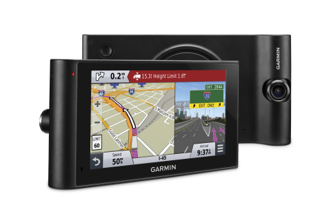
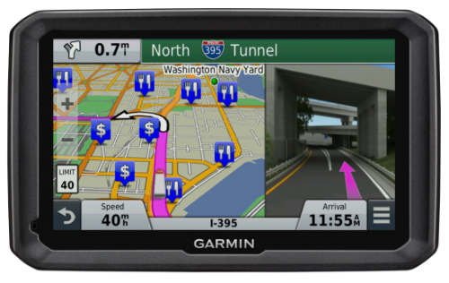
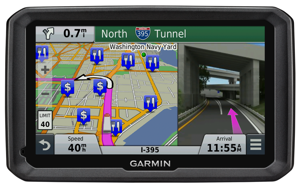
The Garmin dezlCam trucking navigator has a built-in dash cam.
Garmin International Inc. is offering dēzlCam, an all-in-one trucking navigator with a built-in dash cam that serves as an onboard eyewitness. Truckers can rely on firsthand video footage that continually records the drive and automatically saves video footage on impact.
The dēzlCam provides custom truck routingfor the size and weight of a driver’s truck as well as route warnings for bridge heights, weight limits, sharp curves, steep grades and more.
“The dēzlCam is an innovative navigation solution for truckers,” said Dan Bartel, Garmin vice president of worldwide sales. “As technology evolves, so do the needs of truck drivers who spend their lives on the road. Truckers will like dēzlCam especially because of its premium trucking features combined with an integrated dash cam that records proof of road incidents and protects their driving reputation. The combination of these features adds significant value to our trucking community.”
This premium truck navigator features a six-inch pinch-to-zoom display, a built-in dash cam with an adjustable swivel lens, and a magnetic mount to quickly secure or remove the dēzlCam from a driver’s truck. The built-in dash cam starts recording as soon as the dēzlCam is powered on, while the Incident Detection (G-sensor) automatically saves footage of collisions upon impact.
Location, speed, date and time data can be optionally recorded allowing drivers to know precisely when and where an incident occurred. The Snapshot feature captures still images and provides truckers the freedom to remove the dēzlCam from their truck to take close-up pictures. Users can also play back driving footage directly on the device, or review on a computer using garmin.com/dashcamplayer.
A comprehensive directory of preloaded TruckDownLocations and Services make it easy to find places highly rated by truckers. Drivers can filter trucking points of interest to find locations with their preferred brands or amenities.
The dēzlCam is also bundled with Foursquare data that adds millions of new and popular points of interest to the navigator’s searchable database. Easy Route Shaping lets drivers modify a route to include preferred cities or roads by touching the screen. The Up Ahead feature displays a constant stream of nearby services, such as upcoming rest areas, fuel stations and restaurants.
The dēzlCam also provides a history log to record fuel usage, IFTA mileage and hours of service, and displays mile-marker information, automatic time zone changes and alerts drivers of upcoming state and country borders.
Created with safety in mind, the dēzlCam offers advanced navigation features that aid truckers in reaching their desired destination. Voice-activated navigation lets truckers control the dēzlCam with their voice, while Bluetooth technology allows for hands-free calling and pairing with a Bluetooth-enabled headset (sold separately). The dēzlCam is also compatible with the Garmin BC 30 Wireless Backup Camera (sold separately) to easily see behind a truck when in reverse. Spoken Garmin Real Directions can help drivers locate hard-to-find addresses with spoken directions that use recognizable landmarks, buildings and traffic lights. Active Lane Guidance with helpful voice prompts indicates the proper lane needed for a trucker’s route, while realistic Junction View imagery helps navigate complex interchanges with ease.
The dēzlCam comes equipped with preloaded maps of North America with free lifetime map updates, as well as free HD Digital traffic that provides updates as often as every 30 seconds. Drivers can also download the free Smartphone Link app to access live weather radar on the dēzlCam and other real-time data services from a compatible iPhone or Android™ smartphone.
The Garmin dēzlCam is expected to be available this month with a suggested retail price of $499.99.
Lawyers for 11 Pennsylvania residents injured in 2013 when their charter bus slammed into an overpass in Boston, Mass., are suing GPS device manufacturers TomTom and Garmin, seeking more than $15 million in damages.
The bus driver was using both a Garmin and a TomTom satnav, neither of which were intended for use by commercial vehicles, but the lawsuit filed in January claims that the GPS units were at fault for not providing road height restrictions.
The bus driver, Samuel J. Jackson, told police he drove the 11-foot-high bus onto Soldiers Field Road, which is off-limits to vehicles more than 10 feet high, because he was “following the GPS.” At least one sign warning of this restriction was missing or damaged, and construction on the Harvard Street overpass obstructed other warning signs, the suit said.
Passengers were injured when the bus roof crushed backwards in the crash dropping the luggage rack and television onto the heads of the passengers, the Boston Globe reports.
Both TomTom and Garmin manufacture GPS units for professional drivers which feature information on bridge underpass height restrictions.
Because of nonstop government regulation, which can help and hinder the trucking industry, the mobile resource management market will continue to be one of the strongest location segments. In other news this month, while it doesn’t get much bigger a deal in the location industry than a $2.5 billion purchase, as in the case of Qualcomm buying CSR, one smaller deal that should not be overlooked is ST Telecom’s acquisition of Shopkick, a growing indoor location provider.
SAN DIEGO — The global trucking market for fleet management products has always been strong — and one of the first location segments to have prospered over the last 15 years. This market growth will continue because of new technology and government requirements, say attendees at the American Trucking Association annual management conference here.
An American Transport Research Institute report offered at ATA, “Critical Issues in the Trucking Industry – 2014,” outlines 10 issues, mainly driven by government regulation, that concern fleet owners.
One of the big issues is hours of service (HOS). Rules adopted by the feds require 11 hours of driving — and a 34-hour break before restart. This includes a 30-minute break before driving again after eight hours. ATRI believes these rules cost carriers $1.6 billion to $3.9 billion annually in driver pay impacts.
An electronic device (ELD) mandate requires all drivers to keep records of duty status via a logging device. A mandate could come in 2016 that outlines hardware specs.
Another big issue is truck parking — and could be an opportunity for mapping and location companies. Because HOS regulations require drivers to take many breaks, shortage of parking is a big and dangerous concern because drivers are operating beyond allowable rules to find areas to park. ATRI wants closed public rest areas to reopen. They want real-time truck parking information availability and trucking parking reservation systems.
Driver distraction in the form of texting and driving is a growing concern. ATRI wants the feds to ban hand-held cell-phone use/texting for all motorists, encourage harsher penalties and more aggressive enforcement, and to continue to research to understand the size of the distracted-driving problem.
Other issues include driver shortage, health and retention; compliance, safety, Accountability (CSA); and congestion funding.
“My takeaway from [ATA’s] luncheon panel was that the trucking sector is in pretty good shape overall, except for the driver shortage. In regard to mobile resource management (MRM), I would estimate overall growth in in-cab and trailer monitoring at less than 10 percent per year,” said Clem Driscoll, president, CJ Driscoll Associates. “The Truckload sector is heavily penetrated with in-cab solutions. Most large carriers have a system. CSA is motivating some sales to mid-size fleets, but many small fleets are waiting for the ELD regulations. So, the delays with ELD regulations have probably been slowing market growth.”
Such companies as AT&T are trying to address the growing trucking requirements with new and existing products. For example, Saia LTL Freight, a trucking and logistics company, is managing its fleet of trucks with several AT&T products. Saia drivers are using handheld computers to connect with dispatch managers and monitor fuel consumption, safety, and location using AT&T’s wireless network.
“[SAIA] is a trucking company that is using all our capabilities. We partnered with them from an early stage, starting with the [Electronic Device Mandate] requirements,” said John Moscatelli, AT&T advance resource management solutions director. “Then we helped them with rugged handhelds and voice where necessary.”
Overall, Moscatelli sees a few fleet trends emerging. “There have been a lot of mergers and acquisitions in this industry. I also see that trucking companies are very aware of forced hours of service regulations for every company [mandated by the government],” he said. “It will not necessarily be the first adopter of technology that will be needing units. We have looked at the demographics, and even small and medium fleets are going to need affordable connected systems. The other trend is the growth of government sales — local, state and federal — very strong.”
Targeting a large worldwide market, Trimble has acquired several companies in the fleet space in recent years. One of them is Minneapolis-based PeopleNet, which is gearing up for the ELD mandate with an “Internet of Transportation Things” strategy that includes multiple devices talking to each other, said Randy Boyles, company senior vice president, tailored solutions.
The company rolled out its Wi-Fi-enabled in-cab scanning feature at ATA that allows drivers to scan and transmit transportation documents.
PeopleNet, along with ALK, GEOTrac, Vusion and TMW Sysems, are part of Trimble’s Transportation and Logistics division. Trimble has allowed their purchased companies to operate autonomously.
“About 95 percent of our management team is still intact. TMW still works with Omnitracs and others, but you will see a convergence with [other Trimble companies],” said Boyles, who believes that oil and gas pipeline monitoring/mapping is a growing niche.
The fleet and enterprise market is a growing space for Magellan, said Mark Perini, company associate vice president. The company has been offering its Magellan RoadMate 9496T-LMB Android unit for the fleet market.
“The unit enables bulk updates using our smart GPS technology. The Android operating system has been a growing technology for fleets,” Perini said. “The HOS regulations require reporting of how many hours truckers are off duty. With our management system, operators can implement a full set of protocols [to achieve HOS compliance]. It’s on a server, so the driver can’t change anything.”
Telogis Partners with Ford
Telogis has grown from a small company to a major player in the fleet market. The company recently announced it will be the “technology provider” for the Ford Crew Chief in North America, which is an expansion of its European partnership with the automaker.
In Europe, Ford’s telematics products will be offered to customers as a dealer-installed option and will feature vehicle location, diagnostics and performance.
The company has also been a major player in the U.S. market, integrating into Volvo Link, said Kevin Moore, Telogis vice president of OEM sales at ATA.
“While the trucking business is huge, the aftermarket is also growing,” he said. “While location information is central to what we do, we are constantly growing the platform. We are looking to be the only product that provides crowdsourcing for the commercial market.”
Even though the U.S. fleet market is growing, other world markets are growing by double digits each year. Driscoll, in his China Commercial Telematics Market Study, says the Chinese markets are growing at 20 percent, or more, each year. “China is manufacturing over 600,000 commercial trucks per year for internal use, so the addressable market is growing at a very fast rate,” he said. “China has a very inefficient logistics system and spends far more on logistics than the U.S. or Europe as a percentage of GDP. The government is very aware of the problem and is mandating the use of satellite tracking solutions in a number of sectors. Systems being sold in China today typically support both GPS and BeiDou (Compass).”
In other ATA news:
Orbcomm rolled out its GT 1100 chassis tracking solution to allow trucking companies to monitor where their rigs are located. It also allows operators to see if a trailer is mounted.
10-4 Systems is offering real-time data products NonStop, NonStop Mobile and NonStop premium. The company has a track/trace asset management capability for operators.
Qualcomm to Buy CSR for $2.5 Billion
The recent announcement by Qualcomm saying it would buy United Kingdom-based CSR for $2.5 billion signals continued inroads into the connected car and Internet of Things markets for the San Diego company.
In 2009, CSR, which stands for Cambridge Silicon Radio, purchased SiRF Technology, a GPS pioneer that was making huge strides in indoor location technologies. CSR, mainly known for its wireless Bluetooth technology, has chips in such products as audio speakers and Apple-owned Beats headphones.
The connected car market will be a big one for Qualcomm in the future. The connect car market, a dominant topic at most wireless trade shows, is expected to grow to $20 billion by 2018, according to Juniper Research. Another research company, SBD, has even higher expectations for the technology, saying the connected car market will grow to $54 billion by 2018.
Macy’s plans to add Shopkick indoor location beacons in preparation for holiday shopping. (Photo by Nicholas Eckhart is licensed under CC BY 2.0.)
Shopkicking It at Macy’s
In another big industry acquisition, SK Planet, part of South Korean mobile carrier SK Telecom, bought indoor location provider Shopkick for $200 million. The sale indicates how valuable the worldwide indoor location market is becoming.
Macy’s announced it was installing 4,000 Shopkick beacons prior to the holiday shopping season, according to published reports. The company has nearly 8 million active users and relationships with 20 retailers
In other location news:
General Motors OnStar is arguing for less restrictive open Internet rules for wireless carriers, according to published reports. OnStar argues that future connected services (Wi-Fi hotspots, wireless collision avoidance systems, streaming video and audio) that are going into cars make the net neutrality issue vital for the auto industry. The auto giant, which works with such carriers as AT&T Mobility, is siding with the wireless carriers in their battle with the FCC over net neutrality.
A number of location companies, and companies using the technology, are seeing major investments. Most notably, INRIX received a $55 million investment from Porsche. XAd, which develops mobile advertising products, received $50 million in funding from a number of partners. Geofeedia, an LBS social media monitoring company, raised $3.5 million. The company gathers social data from such sources as Twitter, Instagram, YouTube, Flickr, Facebook and others.
Nokia’s HERE mapping platform is now available on Samsung’s Galaxy smartphones. The HERE app, available in Samsung’s Galaxy App Store, will run on devices operating Android 4.1. Currently, Google Maps is the default mapping service on Android phones. However, the HERE platform gives consumers another Android option.
TomTom said it has “extended [its] location-based services product portfolio with an online turn-by-turn navigation service” with support from deCarta. While TomTom has many customers, including Apple, it has never offered an off-board, server-based navigation service. Industry sources say that this announcement will allow TomTom to better compete in the Internet of Things/connected car market.
XRS Corporation, a mobile trucking intelligence company, has announced that Verizon is the official wireless provider for its new collaboration with Samsung Telecommunications America. The new product — NXT — creates what XRS says is the first integrated mobile device and software package designed specifically for the trucking industry.
The new solution brings together powerful XRS compliance and performance tools with Samsung Mobile’s devices, XRS said. Now, NXT is powered by the Verizon 4G LTE network, which provides the platform with superior performance and speed.
“Technology forces in the trucking industry have long been on converging paths, and our new NXT product — powered by XRS in collaboration with Verizon and Samsung Mobile – is a perfect example of how our industry is harnessing the power of technology to benefit drivers and fleet managers,” said Christian Schenk, senior vice president, XRS Corporation. “An integrated platform is the next evolution of convergence, and we are proud to be working with industry leaders like Samsung Mobile and Verizon to deliver the ultimate trucking intelligence solution.”
NXT allows drivers and fleets to purchase select Samsung Mobile devices with an XRS trucking intelligence software subscription and ready for activation on the Verizon 4G LTE network. The first device available is the Samsung Galaxy Tab 7.0, priced at a $100 discount from its suggested retail value. The data plan and subscription cost is $54 per month, including $39 for the monthly XRS fee and $15 for the monthly wireless data fee. This charge covers all required subscriptions and data, including the Relay onboard hardware component, as well as FLX messaging, hours of service, electronic DVIR, IFTA state mileage reporting and more.
“With the explosive growth of mobile electronic devices in the trucking industry, drivers have come to expect reliable and fast wireless service while they are on the road,” said Michael Toto, director of alternate channels for Verizon Enterprise Solutions. “This solution is one example of how Verizon is investing in the success of our channel partners as we collaborate to bring new innovative solutions to the market.”
NXT also offers integration with many enterprise transportation products. Over time, the platform collaboration will expand to introduce additional components, including MDM and wearable products.
The XRS trucking intelligence platform operates in both over-the-road and private carrier configurations, and is suitable for fleets of all sizes. XRS runs on certified smartphones, tablets and rugged handhelds that transmit vehicle and operator data through the cloud to a fleet management dashboard, helping companies to comply with current regulations and soon the pending Electronic Logging Device (ELD) mandate for electronic recording of a driver’s hours-of-service. Nearly 90 percent of drivers already use mobile devices while on the job.
NXT was developed through the Samsung Solutions Exchange, a newly announced strategic engagement model from Samsung Mobile that delivers a range of end-to-end solutions that address real world business challenges. The program is aimed at achieving shared value across Samsung Mobile’s rapidly growing ecosystem of enterprise customers, sales channels and alliances.
“NXT is a holistic solution for trucking that addresses performance, safety, and compliance challenges unique to the industry,” said Tim Wagner, vice president and general manager, enterprise business unit – Samsung Mobile. “Through the Samsung Solutions Exchange, we have worked closely with XRS and Verizon to enable a solution that leverages our respective strengths – which for us includes our robust suite of enterprise-grade devices.”
Customers can buy the NXT product either directly through Verizon or through XRS.
ALK Technologies today released the latest version of its PC*MILER truck routing, mileage and mapping software. PC*MILER 27 features and enhancements include a completely redesigned graphical user interface for maximum efficiency and hours-of-service compliance tools for more precise arrival and delivery time estimates.
“PC*MILER 27 is a milestone for ALK. We’re thrilled to unveil this robust yet easy to use interface with an all new look and feel,” said Mike Bodden, Senior Vice President of Technology, ALK Technologies. “The new UI provides an improved user experience with easier product navigation, resulting in increased productivity.”
The new PC*MILER 27 graphical user interface reflects recent trends in software design that result in more intuitive navigation of the product’s vast feature set. The user interface features a ribbon-style design with newly crafted descriptive icons, a more accessible layout for smoother transition between tasks, and windows that can be floated outside the PC*MILER application to better accommodate workspace needs.
PC*MILER 27 features new hours-of-service compliance tools to help ensure that routes and ETAs will accurately reflect drivers’ available hours. The HOS compliance tools increase the precision of arrival and delivery time estimates and help dispatchers and drivers comply with HOS government regulations. Based on remaining hours, PC*MILER calculates when a driver needs to break, and indicates the designated breaks in the detailed driving directions report, automatically updating on-duty hours. Through the PC*MILER|Connect interface tool, fleets are able to import or export the drivers’ remaining hours associated with specific routes. With the pending new regulations, this is crucial to managing driver compliance and CSA safety scores.
RouteSync is a powerful capability that ensures operational consistency between dispatched routes and actual routes, delivering the guidance to drive the miles that are being billed. With RouteSync, routes and preferences are sent from PC*MILER in the back office directly to the latest version of ALK’s CoPilot Truck navigation software in the cab. In addition to maintaining route compliance, RouteSync reduces non-revenue mileage, improves load profitability and increases driver satisfaction.
Enhanced routing, map data and address matching are a major part of each annual PC*MILER release, ALK Technologies said. As part of ALK’s ongoing effort to track nationwide toll costs in the U.S. and Canada, PC*MILER|Tolls 27 includes four new toll discount programs.
The comprehensive suite of PC*MILER 27 integration tools has also been updated and enhanced. PC*MILER interfaces with all leading transportation, logistics and fleet management systems. These products include PC*MILER|Connect, PC*MILER|TCP/IP, PC*MILER|Mapping, PC*MILER|Spreadsheets, PC*MILER|BatchPro and Multi-Version Switch.
PC*MILER runs on Microsoft Windows, UNIX, and Linux platforms, as well as IBM AS/400 (iSeries) and mainframe computers. PC*MILER is also available as a web-based application.
Navevo specialists in satellite navigation solutions for heavy-goods vehicles (HGV) drivers, now offers the ProNav HGV Cyclist Alert. Supplied as standard on the new ProNav PNN420 satnav for truck drivers and soon to be rolled out across all current ProNav systems, the safety feature provides junction alerts at high convergence areas of trucks and cyclists and prompts drivers to take extra care.
The number of cyclists in London is on the rise, along with safety risks that arise when trucks and cyclists both are traversing busy London junctions and interchanges.
The ProNav HGV Cyclist Alert software was developed in association with Transport for London (TfL) to provide a commercial vehicle driver with an audible and visual alert as he or she approaches a junction (or section of road) that has been determined to be a location where there are high volumes of HGVs and cyclists. A warning symbol is displayed on the navigation system’s mapping that projects a 50-meter radius “warning zone” around each HGV/Cyclist convergence area. Drivers are also provided with a short audible tone as a reminder, giving the driver plenty of time to check for any cyclists on the road, Navevo said.
The HGV Cyclist Alert software uses data provided by TfL and the up-to-date Department for Transport HGV and pedal cycle flow figures for London’s road network. The dataset uses this information to identify locations where large numbers of HGVs and cyclists converge. Initially, 100 high-convergence areas across London have been included (alerts at every junction would be counterproductive to drivers). Working with other local authorities both in London and nationally, Navevo plans to increase the level of coverage and will provide free updates when new data becomes available.
“A navigation system is something a driver is likely to be listening to as they approach a junction, and so it makes perfect sense to also alert the driver of the risk of cyclists, reminding them to be observant and drive safely,” says Navevo CEO, Nick Caesari. “The safety of drivers, cyclists and other users of the road is a concern for everybody, and we are proud to lead the navigation industry by launching this ‘world first’ safety feature, which we believe could significantly contribute in improving road safety and reducing the number of incidents involving HGVs and cyclists.”
“For many years, London has worked to lead the way in pushing for the adoption of safer lorries and safer lorry driving,”
Ian Wainwright, head of Freight and Fleet at Transport for London. “The creation of a specific cyclist alert for HGV drivers is another positive step forward and will help to further raise awareness and improve cycle safety across the capital.”
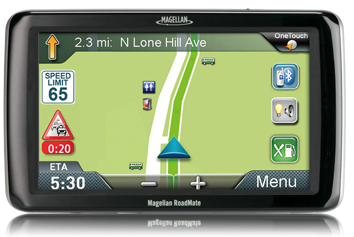
Magellan, maker of innovative GPS devices for vehicles, outdoor and mobile navigation, today announced the newest addition to its Magellan RoadMate Commercial GPS family for truckers and commercial drivers providing improved safety and productivity before, during and after their on-the-road trips. The compliance-ready Magellan RoadMate Commercial 9270T-LM GPS device is specifically designed for the needs of truckers including an extra-large GPS display, customizable truck-specific routing, hands-free communication, and trip logging.
To prepare for their trips, truck drivers can use the Magellan RoadMate Commercial 9270T-LM to set up customizable routes based on the height, weight, width, and length of the vehicle, as well as applicable hazmat restrictions. Multi-destination routing allows drivers to plan their stops and optimize routes to help them save time and gas, Magellan said.
While on-the-road, the Magellan RoadMate Commercial 9270T-LM helps drivers navigate on an extra-wide 7-inch high-definition touchscreen display that adjusts color and contrast for easy night-viewing. The large display also makes maps and other content easy to read when the GPS Navigator is mounted in large vehicles with deep dashboards. The integrated Bluetooth wireless technology, when paired with a compatible Bluetooth phone, enables drivers to safely talk hands-free while keeping their eyes on the road.
At the end of their trip, the Magellan RoadMate Commercial 9270T-LM facilitates preparing required compliance reports including hours and state mileage for IFTA fuel records. A comprehensive log of trip information by each driver is retained in the Magellan GPS device for easy exporting into reports.
“We expanded our family of Magellan RoadMate Commercial GPS Navigators to further meet the unique navigation needs of commercial and truck drivers who need a comprehensive solution to efficiently perform their jobs from the initial trip planning stage to their on-the-road requirements and managing required log reporting after their trip,” said Stig Pedersen, Associate Vice President of Product Management for Magellan. “The Magellan RoadMate Commercial series of GPS Navigators are designed to make drivers’ jobs safer and less stressful plus improve productivity, reduce costs and ultimately increase profits.”
The Magellan RoadMate Commercial 9270T-LM functions as an “information dashboard” that not only navigates, but provides elevation and truck speed limit warnings. The 9270T-LM GPS device includes several valuable safety and convenience features:
Highway Lane Assist that shows realistic highway signs and guides truck drivers towards the correct lane when approaching complex highway interchanges and exits;
Free Lifetime Traffic Alerts that help drivers avoid traffic incidents on their route by offering an alternative solution;
Spoken Street Name guidance that announces the street name and gives turn-by-turn directions;
Highway Exit Points-of-Interest and a Truck Stop Directory help drivers find services including gas stations, restaurants, ATMs, rest areas and showers, truck services, Wi-Fi availability;
OneTouch lets truckers bookmark and assign a button to their favorite destinations or searches for faster access;
Heavy-duty extended windshield mount, designed for deep dashboards, is included to provide fully-adjustable, personalized comfort and safe viewing;
An A/V input for easy connection to external devices such as the Magellan Wireless Back-up Camera or a DVD player;
Free downloadable Lifetime Map Updates keep the pre-loaded maps of the United States, Canada and Puerto Rico up-to-date.
The Magellan RoadMate Commercial GPS family now includes two models — the new 7-inch Magellan RoadMate Commercial 9270T-LM ($399.99 MSRP) and the 5-inch Magellan RoadMate Commercial 5190T ($379.99 MSRP). Both models are available in June at truck stops and through Magellan’s consumer electronics and online partners.