The U.S. Army Corps of Engineers, St. Louis District, has contracted with Aero-Graphics for photogrammetric and lidar surveying and mapping for the next five years. Aero-Graphics is a 56-year-old geospatial services company headquartered in Salt Lake City, Utah.
The $16 million contract is an indefinite delivery indefinite quantity (IDIQ), firm-fixed-price contract.
The services requested are for photogrammetric mapping and related surveys, as well as the preparation of maps for advance planning, design, real property, construction, land-use and land-type monitoring, and analysis for various projects.
“Being awarded the USACE St. Louis District contract is an honor, especially because we will support the Center of Expertise for Photogrammetric Mapping,” said Casey Francis, Aero-Graphics co-president. “Their focus on geospatial rapid response and technical proficiency is directly aligned with Aero-Graphics’ unique process. Our entire team looks forward to supporting this exciting contract.”
Francis added, “Our mantra is ‘agile responses to ever-changing environments.’ We look forward to demonstrating our unique abilities to the St. Louis District, enabling them to accomplish their mission of securing our nation, energizing our economy, and reducing disaster risk.”
New business development specialist hired
Angela Arriaga
In other company news, Aero-Graphics appointed Angela Arriaga as its new business development specialist. In her role, Arriaga will be responsible for expanding the company’s client base.
Arriaga comes to Aero-Graphics with more than 10 years of experience in geospatial, aviation, processing and surveying. “Angela has a strong background in operations management in lidar and ortho imagery,” Francis said.
“Aero-Graphics has always been a staple in this industry with an outstanding reputation and a commitment to excellence,” Arriaga said. “It’s exciting to be a part of this incredible team. The leadership is fully committed to professionalism, passion and enthusiasm for the work. I am looking forward to help continue its expansion and the success of our customers.”
Storm Surge in downtown New York City in the aftermath of Hurricane Sandy. (Photo: USACE)
By JoAnne Castagna
U.S. Army Corps of Engineers
Hurricane Sandy led to one of the largest-scale U.S. evacuations in recent history, according to Edward Schneyer, director of Emergency Preparedness, Suffolk County (N.Y.) Office of Emergency Management.
“During Sandy, we rescued 250 people from their flooded homes, evacuated two major hospitals and several adult care homes,” Schneyer said.
Schneyer was able to do this effectively because his agency uses storm surge maps created by the U.S. Army Corps of Engineers, New York District. Storm surge is when a significant amount of water is pushed from the sea onto the land caused by a hurricane.
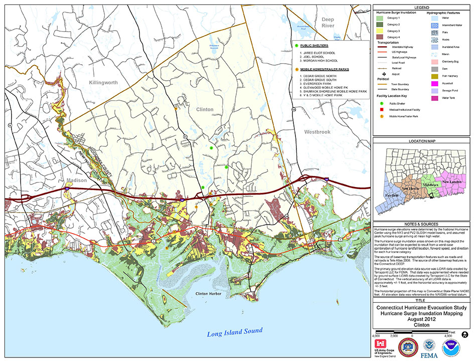
The maps provide emergency managers in hurricane-prone states with an understanding of storm surge potential that could occur for worst-case Category 1 to 4 storms, identifying areas from which people should evacuate if faced with the threat of storm surge.
The Army Corps is updating these maps with higher resolution modeling and topography performed by NOAA’s National Hurricane Center’s Storm Surge Unit, so agencies will have more accurate information to educate the public — reducing risk to themselves and their property.
Hazard Analysis
“Historically, 49 percent of human causalities from hurricanes are due to storm surge,” said Donald E. Cresitello, the Corps’ Hurricane Evacuation Study program manager for the New York District. “Other impacts like riverine flooding due to rainfall, falling trees due to high winds, and indirect impacts like carbon monoxide poisoning and electrocution can cause deaths. The development of these maps is the first step in the hazard analysis for the hurricane evacuation study process.”
The “New York Hurricane Evacuation Study Hurricane Surge Inundation Maps” are being produced in collaboration with the Army Corps’ New England and Baltimore Districts and provided to emergency managers. The Army Corps also guides emergency managers on using the maps in the decision-making software HURREVAC (Hurricane Evacuation), developed by Sea Island Software for the National Hurricane Program.
“Agency officials can use these maps to help reduce risk to the public,” Cresitello said. “They can use them for evacuation planning, to redefine their hurricane evacuation zones, identify where shelters should be located and identify where assets should be staged prior to impact from a storm.”
The new maps will not only show the extent of inland storm surge, but also the depth of the water — in ranges of feet — during different categories of storms, enabling emergency managers to better focus limited resources.
“In the initial stages of a response, our recovery resources are limited, especially for an event the size of Sandy. If resources are dispatched to areas that were not impacted, valuable time is lost mobilizing and reassigning those resources,” Schneyer said.
At press time, Schneyer’s agency is entering information from the maps into an interactive program viewable on its county’s website, so the public can see whether their home is in a storm surge zone and which designated shelter is nearby. During Sandy, people who should have evacuated were stranded and faced dangers such as electrocution from downed power lines and fires from gas leaks.
“This very valuable resource is an excellent tool for public education, emergency management planning, and emergency preparedness in general,” Schneyer said.
Connecticut shoreline: This example of a storm surge map shows the extent of surge that can be expected as a result of a worst-case scenrio that combines hurricane landfall location, forward speed and direction for each hurricane category. (Credit: USACE)
Using GIS to Create Higher Resolution Maps
Geographic information systems (GIS), which capture, store, analyze and display location information, are being used to create higher resolution storm surge maps.
To create the maps, the Corps of Engineers uses the SLOSH model (Sea, Lake, Overland Surges from Hurricanes) provided by the National Oceanic and Atmospheric Administration (NOAA). The SLOSH data is layered over lidar-based topography in Esri ArcGIS software.
“To come up with the actual depth of water through GIS, we are overlaying the data out of NOAA’s SLOSH model and subtracting out the ground elevations using digital elevation models and coming up with an actual depth of water in feet,” said Donald E. Cresitello, USACE Hurricane Evacuation Study program manager for the State of New York, U.S. Army Corps of Engineers, New York District.
JoAnne Castagna is a public affairs specialist and writer for the U.S. Army Corps of Engineers, New York District.
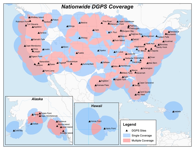
Twenty-two NDGPS sites that serve coastal areas would remain operational under the proposal.
An Aug. 18 Federal Register notice proposes shutting down the Nationwide Differential Global Positioning System (NDGPS) in January 2016 because of a decline in its use, except for sites in coastal areas.
The notice, issued by the U.S. Coast Guard (USCG), Transportation Department (DOT) and Corps of Engineers (USACE), reads:
The Nationwide Differential Global Positioning System (NDGPS) service augments GPS by providing increased accuracy and integrity using land-based reference stations to transmit correction messages over radiobeacon frequencies. The service was implemented through agreements between multiple federal agencies including the USCG, DOT, and Army Corps of Engineers, as well as several states and scientific organizations, all cooperating to provide the combined national DGPS utility.
However, a number of factors have contributed to declining use of NDGPS and, based on an assessment by the Department of Homeland Security, DOT and USACE. DHS, DOT and USACE are proposing to shut down and decommission 62 DGPS sites, which will leave 22 operational sites available to users in coastal areas.
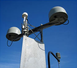
A DGPS reference station antenna.
Contributing factors cited in the decision are:
USCG changes in policy to allow aids to navigation (ATON) to be positioned with a GPS receiver using Receiver Autonomous Integrity Monitoring (RAIM), which assesses the integrity of a GPS signal within the receiver;
increased use of Wide Area Augmentation System (WAAS) in commercial maritime applications, which uses ground-based reference stations and satellite communications to improve accuracy;
limited availability of consumer-grade NDGPS receivers;
no NDGPS mandatory carriage requirement on any vessel within U.S. territorial waters;
the DOT Federal Railroad Administration’s determination that NDGPS is not a requirement for the successful implementation of Positive Train Control (PTC), which provides the railway system the capability to positively enforce movement authorities along railroad systems.
In April 2013, announced that DHS and DOT were in the process of analyzing the need for NDGPS. “The response to the 2013 notice was limited, but the responses received were well informed on the NDGPS system, its use, and current and potential applications,” the notice reads. “While a limited number of responders found the broadcast of corrections to be beneficial, no respondents reported the discontinuance of DGPS broadcast to be detrimental or harmful. Ship pilots in particular noted that DGPS can be critical in confined waterways for precise ship-handling maneuvers.”
Public comments on the proposed shutdown and decommissioning of 62 DGPS sites are being accepted until Nov. 16. Termination of the NDGPS broadcast at these sites is planned to occur on Jan. 15, 2016.
Full details on how to submit public comments can be found on the Federal Register page.