Every ounce counts on a drone. While a larger ground plane on a GNSS patch antenna improves its performance, the additional size increases weight — an unacceptable tradeoff.
The antenna’s location on the drone is another factor. It must be distant from motors and other electronic components that generate interference, which undermines positional accuracy. But remote locations are often off-limits because the antenna’s weight in those spots would disrupt the delicate balance drones require.
Drone-maker Parrot took these factors into consideration when choosing a GNSS antenna for its ANAFI USA drone. Although it weighs just 500 grams, ANAFI USA is designed to operate in winds up to 53 km/h.
To meet these challenges, Parrot chose the Taoglas DSGP.1575.15.4.A.02, a passive patch antenna that supports GPS L1 and Galileo E1. At 3.3 grams and 4 mm high, with a 15-mm2 footprint, the DSGP.1575 is designed for ultra-compact devices.
Key customers
High GNSS accuracy and reliability are critical for Parrot customers such as the French military, which recently ordered 300 ANAFI USA drones for reconnaissance and intelligence missions by its conventional and special forces.
Manufactured in the United States, ANAFI USA has also been selected by U.S. federal government partner organizations as part of the Blue sUAS project — the only UAV from a non-American drone manufacturer to be commercialized on the GSA Schedule, the buying platform of the U.S. military and civilian government agencies.
Police departments, federal agencies and firefighters in the United States and other countries also use ANAFI USA. The drone is also used for surveying, inspection and other commercial enterprises.
Tuned on a 50×50 mm ground plane, the DSGP.1575 operates at 1575.42 MHz with a 2.59 dBi gain. It uses ceramic materials — suitable for UAV applications because drones spend most of their time flying parallel with the horizon, a position in which ceramic antennas collect sufficient GNSS signals to meet performance requirements.
The DSGP.1575’s light weight and energy efficiency enable the ANAFI USA to carry bigger payloads and fly longer, up to 32 minutes compared to the consumer model’s 25 minutes.
“We chose Taoglas because of the quality of their antennas and their ability to tune an existing antenna in the mechanics of the product and to make it on a large scale for mass production,” said Meryam Abou El Anouar, Parrot technical leader for RF and Connectivity. “They are also known for their great experience with the GNSS propagation specificities as multipaths, so that is helpful when you try to achieve good GNSS accuracy.”
Taoglas provided Parrot with design and testing support in its design centers, as well as making regular visits to Parrot’s facility in Paris.
“Our engineering team managed to carry out tests at antenna and system levels,” said Baha Badran, Taoglas Global Antenna Technology director. “This includes passive antenna testing, in-chamber active antenna testing and GPS field testing of the drone. Each of these tests was carried out to ensure optimum GPS system performance was achieved, to give the highest possible positional accuracy for such an application.”
The support also helped Parrot minimize the cost and lead time for bringing the ANAFI USA to market.
The world so close has never seemed so far away. Locked up and adrift, somewhere between the comfort of the past and the anxiety of the future, the present slowly passes by in a procession of nameless days. The living room has become a sundial. Shadows pass from one wall in the morning to the far side by day’s end. Outside, spring has sprung, but inside, winter lingers on.
Alone, we can do so little. Together, we can do so much. —Helen Keller
Times like these, detached and disruptive, are opportunities in disguise. Ironically, while the world is confined and socially distanced from one another, humanity is more connected than it has ever been. Hard to believe, but smart mobile devices began just over a decade ago; and we are in the midst of a growing tsunami of connected devices, cloud computing, big data and open source. These events, coinciding with the exponential growth of geographic information systems and data analytics, have set the stage for crowdsourcing and citizen science. The era of empowering individual contributors has begun.
It has probably gone unnoticed due to all the political wrangling in Washington, D.C., but over the last two administrations, with bi-partisan support, without recognition or renown, a monument to American ingenuity was christened. Beginning in 2010, the America COMPETES Reauthorization Act was passed. Then, in 2014, the White House elevated homegrown inventors and creators calling it the Maker Movement and hosted the first-ever National Maker Faire. In 2015, the STEM Education Act became law and in the same year the Senate introduced The Crowdsourcing and Citizen Science Act. In 2017, the American Innovation Competitiveness Act became law formally coining the term, crowdsourcing. In 2019, the White House Office of Science and Technology Policy (OSTP) delivered the first-ever comprehensive report to Congress about federal agencies activities involving crowdsourcing and citizen science (FedCCS). Also in 2019, OSTP along with the General Services Administration (GSA) hosted the U.S. Government Open Innovation Summit.
The OSTP FedCCS report to Congress titled, “Implementation of Federal Prize and Citizen Science Authority,” cites 169 FedCCS prize competitions conducted by 18 federal agencies, such as the National Aeronautics and Space Administration (NASA), the Centers for Disease Control (CDC), and the National Institute of Science and Technology (NIST). However, the number of FedCCS projects is much greater than what is covered in the report. On Challenge.gov the amount of competitions rose from 744 in 2016 to 875 in 2018, and the prize awards ranged from $0 to $20 million with an average payout of $75,000 in FY2018. The next report is due in 2021.
Governments tapping into the resources of its citizens for innovation is not new, but it has never been on this scale and granted such authority. One of the first official attempts was the United Kingdom’s Longitude Prize in 1719 offering a King’s ransom of £20,000 [see article: From the Pyramids to GIS/GPS] to solve positioning at sea. Great Britain still honors the original Longitude Prize using the name for their national grand crowdsource competition. Similarly, in the United States the grand challenge is the X-Prize, the most famous one being the Ansari X prize. You may not know the prize by its name, but as NASA’s Space Shuttle Program phased down, the Ansari X-Prize kicked-off the space race among private companies. Scaled Composites won the $10 million prize in 2004 reaching space in a reusable craft, which became Virgin Galactic.
The term “crowdsourcing” means a method to obtain needed services, ideas, or content by soliciting voluntary contributions from a group of individuals or organizations, especially from an online community. —15 USC Chapter 63 §3724 (2): Crowdsourcing and Citizen Science
The U.S. Federal Government already relies on the public for information to help improve and maintain its products and better serve the country. The National Oceanic & Atmospheric Administration (NOAA) has had an ongoing cooperative with the U.S. Power Squadrons since 1963 to report safety hazards to navigation and help maintain the information on maritime nautical charts. The agreement to support NOAA was renewed in 2013 for another 50 years.
Image: U.S. Geological Survey
The Federal Aviation Administration (FAA) accepts reports from the general public, especially aircraft pilots regarding the accuracy of information in the products it publishes which can affect changes to aeronautical charts and flight operations.
The U.S. Geological Survey (USGS) has The National Map Corps (TNMCorps), which began in 1994 with the Earth Science Corps and the Adopt-a-Quad program. These two programs consolidated into a single online crowdsourcing effort to support USGS in 2013. TNM Corps helps maintain USGS’s maps and allows private citizens to do feature collection activities. It is easy to join and simple to use making it a way for all ages to join the crowdsource movement. What is also significant about USGS is that Dr. Sophia Liu, Co-Chair of the Federal Community of Practice for Crowdsourcing and Citizen Science resides there. Dr. Liu helped stand-up FEMA’s crowdsourcing and citizen science unit in 2007. She is now the coordinator of FedCCS activities and helped co-write the 2019 OSTP FedCCS report to Congress.
Crowdsourcing is about actively engaging people in a certain task, sometimes a very specific micro-task that includes a two-way feedback loop with the public. We need to leverage the human power that is better at understanding, processing, and communicating information.
—Dr. Sophia B Liu, Innovation Specialist, USGS
Some of the most popular sites for GIS enthusiasts to get involved are Open Street Maps (OSM), GISCorps, GeoHIVE and Zooniverse. OSM has more than 2 million contributors worldwide and has been on the front line of international disasters beginning with the 2010 Haiti Earthquake. Through its Humanitarian OpenStreetMap Team (HOT) it has supported operations of the Red Cross, FEMA, and United Nations. Through the power of the crowd, OSM contributors rapidly map transportation networks in disaster areas to show the most accessible routes in order for rescue operations and emergency supplies to reach the most impacted communities.
The GIS Corps, founded in 2003, operates under URISA and coordinates short-term mapping volunteer projects for humanitarian relief, human rights, disaster response, and other important efforts. Over 4,500 volunteers have helped support 195 missions around the world such as Hurricane Katrina, Ebola outbreaks in Sierra Leone, and the Nepal earthquake, in fact, if there is a crisis somewhere in the world, GISCorps is most likely going to have an effort in place to support it.
GeoHIVE (Geospatial Human Imagery Verification Effort) is an imagery based geospatial crowdsource platform which began in 2015 eventually replacing Tomnod in 2018. Digital Globe formed a collaboration with Radiant Solutions, SSL and MDA combining efforts and resources creating a more robust crowdsourcing platform. GeoHIVE’s 3,000 volunteers have contributed to nearly 700 campaigns. Registering for GeoHIVE requires an Amazon Mechanical Turk account, which allows contributors to be compensated for crowdsource tasks.
Zooniverse began as an astronomy site to enable hobbyists to help classify galaxy types but quickly grew into a crowdsource platform that encompasses all sorts of projects in addition to its cosmic origins including art, biology, literature and there are several spatially related projects to be found, as well. With Zooniverse you can contribute to science by studying gravitational waves or categorizing auroras as the ionized plasma washes up onto our cosmic shore.
90% of all the scientists who have ever lived are alive today. —Steven N. Rader, Deputy Manager, NASA, Center of Excellence
That quote by Steven Rader of NASA is accredited to Derek de Solla Price in 1961 referring to the exponential growth in the number of PhD’s and patents throughout the world. But now, science is in the hands of the Makers — those with 3D printers or those who can program a virtual world, or design an augmented reality, or those who can extract patterns from data and provide meaningful intelligence in geography, demographics, genetics, biology, and every field of study.
Citizen scientists are making a significant mark upon the world. Take for example CeCe Moore, a genealogy hobbyist who became a self-taught expert and now tracks down killers solving several cases using her laptop and open source DNA records. Gary Hug, a backyard astronomer, who built his own observatory in Topeka, Kansas, has discovered over 300 asteroids in near Earth orbits, and in March, Michael Mattiazzo, a citizen scientist astronomy enthusiast, discovered comet (C/2020 F8) SWAN which will make its closest approach to Earth on May 13th inside Earth’s orbit. Then there is Ted Ground, a citizen scientist hero. Ted is a winner in multiple citizen science competitions winning the NASA ideation challenge for the Mars ballast payload, the Bureau of Land Reclamation challenge for identifying insect invertebrates in rivers and estuaries, and the INNOcentive challenge for identifying trace minerals in livestock.
The day before something is truly a breakthrough, it’s a crazy idea.
—Peter Diamandis, executive chairman of the X Prize Foundation
Challenges are competitions sponsored by governments, private industry, non-profits and international entities. At the end of this article are listed several challenge sites. Agencies of the U.S. government post their challenges on Challenge.gov and CitizenScience.gov. Challenges are opportunities to work on projects for NASA, DOD, EPA, NOAA, FEMA, USGS, DARPA, and a growing list of agencies and companies. Most of these projects can be worked on at home with a laptop. Some challenges are for money or other prizes and some are just for the recognition, but all of them are ways to improve skills, build connections, and enhance a resume.
In closing, the legislation signed into law since 2010 culminating in the America Innovation and Competitiveness Act of 2017 requiring bi-annual reports to Congress directs federal agencies to use Crowdsourcing and Citizen Science. This movement empowers the individual. There has never been a better time for an idea whose time has come.
All achievements, all earned riches, have their beginning in an idea. —Napoleon Hill, Author of Think and Grow Rich
A final note: The four-part television series, “The Crowd & the Cloud,” sponsored by the National Science Foundation (NSF) and hosted by Waleed Abdalati, former NASA chief scientist, can be seen here.
In March, the U.S. government received an unusual inquiry about GPS disruptions. It was from a user in Iran reporting what appeared to be “circle spoofing” — a phenomenon that had only previously been observed in China.
“Some of GPS devices received fake signal and show the fake valid location. Yesterday I test a device, it can get signal and give real position. After 10 minutes the device show moving around a big circle in tehran by 35 km/h speed. I can’t fix this problem by restarting the device.
“The GPS module time is correct but the location is not. I attach Excel file of data and map of the track. I can’t get any response from Communications Regulatory Authority (CRA) of The I.R. of Iran. Do you know about this?”
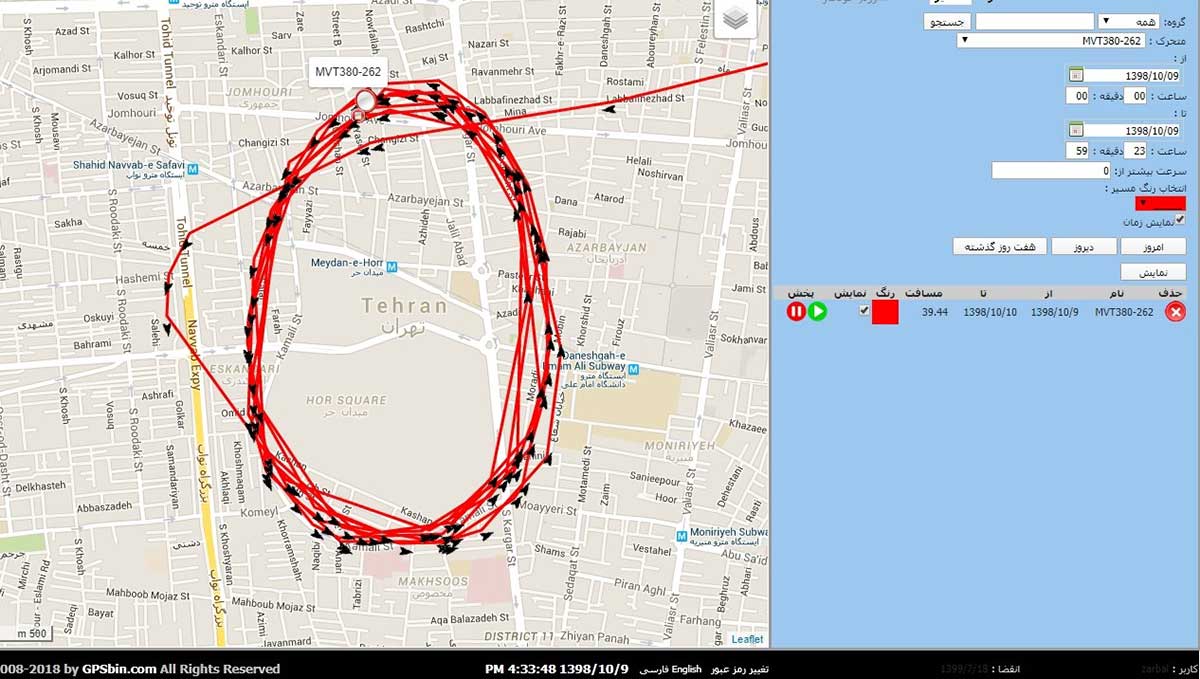
Here is one of the images provided by the reporting source:
GPS spoofing device in operation at Iran’s Army Command and Staff College. (Screenshot courtesy of Dana Goward)
A little internet research showed that the spoofing was taking place at or near Iran’s “AJA University of Command and Staff,” formerly called the “War University.” It is the staff college for Iran’s Army.
Reports to the U.S. government about GPS disruption are normally listed on the U.S. Coast Guard’s Navigation Center website. This one has not been posted. Coast Guard officials said that it is because the report was received by another agency and did not contain sufficient information. Attempts by Coast Guard personnel to contact the reporting source for more information to enable the report to be posted were unsuccessful.
GPS spoofing is often easiest to detect in maritime areas. Ship automatic identification system (AIS) transmissions include location data and are detected by satellite. The data is then aggregated and used by various companies for a number of applications. Viewing ship location reports over time has revealed thousands of ship receivers spoofed to airports in Russia, and hundreds spoofed into circles (presumably around the spoofing device) in China.
Clearly, though, any system that aggregates and displays GPS location data can help detect wide area spoofing activity.
Strava is a mobile app for runners and cyclists. The company aggregates location data and displays it on a heat map to highlight athletes’ favorite routes.
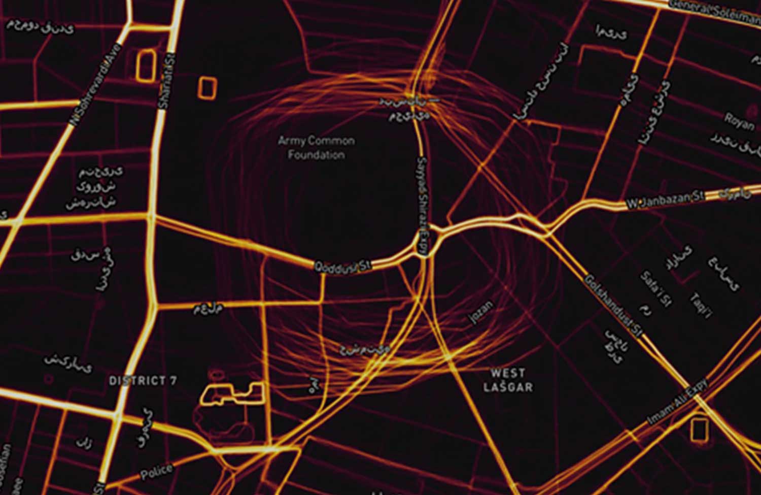
The Strava heat map for Tehran shows that circle spoofing has also been employed in at least one other location. The below screenshot shows GPS-enabled fitness trackers circling a government complex that houses offices for several defense and technology-related organizations.
This heat map shows GPS spoofing at a government complex in Tehran,which houses the Ministry of Defense, Communication Regulatory Authority, Telecommunications Infrastructure Company, and Ministry of Telecommunications and Technology. (Screenshot: courtesy of Dana Goward)
Iran was the first nation to publicly announce it had the ability to spoof GPS signals and seems to have used it to great advantage.
In 2011, a CIA drone that had been operating across the border in Afghanistan landed at an Iranian airfield. Iran’s government claimed that its forces had sent false signals to the drone’s GPS receiver in order to capture it.
At first, U.S. government officials said that this kind of spoofing was not possible. Several months later, Prof. Todd Humphreys demonstrated how it could be done to a drone at the University of Texas football stadium.
U.S. officials then admitted that spoofing was possible, but said it wasn’t what happened to the CIA drone. At the same time, they offered no alternate explanation of how the drone was captured.
In 2016 Iranian forces captured two U.S. Navy boats that had strayed into Iran’s territorial waters. This was just after President Obama had succeeded in pressing that nation to give up nuclear weapons research, and was on the same day as Obama’s last State of the Union address. There was little reason for the U.S. Navy boats to have veered so far off course, and it was clear that the Iranian Navy was waiting for them.
Many speculated that Iran had spoofed GPS signals to lure the U.S. Navy boats into Iranian waters. U.S. officials have denied that this was the cause of the incident, but have not publicly offered an alternate explanation other than “mis-navigation.”
During heightened tensions in the Persian Gulf in 2019, Iran shot down a U.S. surveillance drone and President Trump seemed ready to launch a retaliatory strike. This was called off at the last minute. According to some reports, the strike was canceled because of the likelihood the drone was in Iranian airspace at the time.
At about the same time British intelligence was warning merchant vessels in the area that Iran was attempting to use GPS spoofing to lure them into Iranian waters as a pretext for seizing the ships.
While the Middle East has been a hotbed of jamming and conventional spoofing for years, these recent circle-spoofing incidents are the first of the kind we know of in the region. It may well be that Iranian forces have recently received equipment from China and are experimenting with it. They could also be using it to deter GPS guided drones and disrupt other surveillance systems in the vicinity of sensitive government facilities.
Orolia, a resilient positioning, navigation and timing (PNT) company, has entered into a definitive agreement to acquire Talen-X.
Talen-X is a U.S. technology innovator with the ability to characterize, enhance and implement advanced techniques and products to solve real-world GNSS vulnerability problems. It has expertise in GPS/GNSS performance, requirements, testing, integration and threat mitigation.
Orolia has completed 10 acquisitions since 2007, including Spectracom, Spectratime and McMurdo brands. The transaction is subject to customary closing conditions and approvals required by the U.S. Defense Security Service (DSS) and the Committee on Foreign Investment in the United States (CFIUS).
Through this acquisition, Orolia said it will significantly enhance Assured PNT capabilities across the global company’s portfolio to support mission-critical applications. The additional resources also strengthen Orolia’s commitment to serving the U.S. government, with further expansion of domestic capabilities and a greater U.S. footprint. Toward that end, the companies will reinforce their commercial cooperation to maximize market awareness and access.
“Military personnel know that accurate and trusted time and position information is a critical enabler for almost all warfighting functions and systems,” said Orolia CEO Jean-Yves Courtois. “Reliable PNT data are critical for communications, sensors, network synchronization, situational awareness, command and control or search and rescue missions. This acquisition reinforces Orolia’s position as a major supplier of Assured PNT technology and enhances our ability to offer unique end-to-end solutions.”
Talen-X has extensive technology integration and PNT engineering resources that will enable Orolia to rapidly develop and offer new, superior products and services to the U.S. market.
“Our culture of innovation, together with our demonstrated testing capabilities, will complement Orolia’s global technology expertise and significantly enhance the reliability, performance and safety of military operations,” said Tim Erbes, CTO of Talen-X.