The U.S. Federal Aviation Administration (FAA) has warned all pilots to “exercise caution” when flying in the airspace over Venezuela “due to the worsening security situation and heightened military activity,” reports ABC News. Possible risks include GNSS jamming and spoofing.
The FAA message said the unspecified threats “could pose a potential risk to aircraft at all altitudes” as well planes taking off and landing in the country and even aircraft on the ground.
The warning comes as the Trump administration has ramped up pressure on Venezuelan President Nicolás Maduro. The Trump administration also has carried out a series of strikes on small boats in the Caribbean Sea and eastern Pacific Ocean that it accuses of ferrying drugs to the U.S., killing more than 80 people since the campaign began in early September.
The Ford aircraft carrier and several destroyers were just the latest addition to the largest U.S. force assembled in the Caribbean Sea near Venezuela in generations. The Trump administration does not see Maduro, who faces charges of narcoterrorism in the U.S., as the legitimate leader of the South American country.
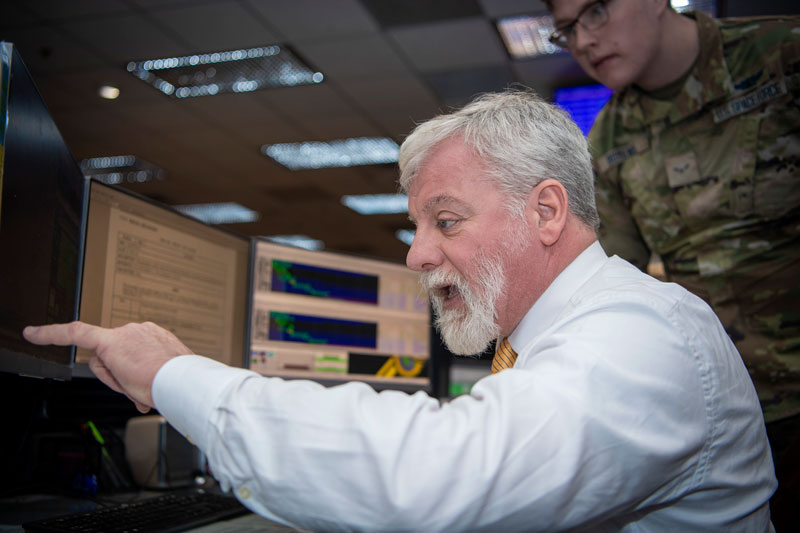
On the operations floor of the GPS Master Control Station at Schriever Space Force Base in Colorado, Luccio looks at feeds from a worldwide network of monitor stations and ground antennas. (Image: U.S. Space Force photo by Dennis Rogers)
The young operators on duty at the GPS Master Control Station, at Schriever Space Force Base in Colorado, receive feeds from a worldwide network of monitor stations and ground antennas, monitor the GPS satellites, and send them commands as needed. This month’s cover story features excerpts of an interview with their commander, Lt. Col. Robert O. Wray, about the training and duties of his team members, the challenges they face, and what brought him to his current assignment.
Artists rendering of the B-21 raider, which is being produced by Northrup Grumman for the U.S. Air Force to operate in tomorrow’s high-end threat environment. (Image: U.S. Air Force)
With assured positioning, navigation and timing (APNT) and low-Earth orbit PNT (LEO PNT) coming on strong, what does the future hold for military and commercial systems dependent on the current configuration of GPS? Should military and commercial platforms be modified to include APNT, for now, with an eye to adding LEO PNT in the future? Should they integrate these two systems, or rely on one or the other as standalone systems?
Government and industry agree that interference with GPS and all GNSS is an increasing threat as jamming and spoofing technologies evolve. This has prompted government support for APNT to bolster GPS. A Feb. 12, 2020, Executive Order required a comprehensive update to national policy on PNT services by the federal government, and by owners and operators of critical infrastructure to strengthen the resilience of critical infrastructure.
Research, development and production have improved the performance — positioning, timing and (desired) accuracy — of GNSS PNT and the ability to operate in RF-challenged environments. APNT gives the U.S. military a reliable way to further enable GPS, or to act as an alternative to it, by utilizing other sensors, such as inertial navigation systems, differential GPS, visual sensors, lidar, radar, radios and star trackers that complement GPS.
The near-term expansion of internet service to include commercial broadband LEO satellites also provides potential for robust PNT, using their waveforms as signals of opportunity (SOOP). GPS and other GNSS have an infrastructure to maintain very precise time throughout their constellations, as well as satellites with specially designed transmitters, clocks, and a waveform dedicated to the PNT function. By contrast, SOOPs are in space for another purpose and not optimized for PNT. Therefore, the challenge is to exploit features of the SOOP waveforms, designing innovative techniques to determine the range to each satellite and to provide users with reliable PNT. The approach for LEO PNT may have applications to ground troops and for aerial, munition, missile and commercial applications requiring higher levels of PNT security and integrity.
GPS receivers for future military platform designs may use a software defined radio (SDR) approach and be capable of incorporating LEO PNT signals. This technology, although designed to work standalone, can be used to complement existing navigation sensors that are typically used in navigation systems, including APNT. Expansion to the usage of multiple constellations will serve to optimize performance and resiliency in an RF-challenged environment. However, LEO satellites’ closer proximity to Earth and their signal structures allow for higher signal powers, thus are more robust against jamming. With all these separate systems or fusion by SDR, how does the receiver ensure the integrity of the signal or its accuracy? An SDR qualification test would involve an unlimited number of scenarios.
One hallmark of the GPS program is that it facilitates a thorough systems engineering effort by managing in a single location interface control documents (ICDs) for alternative systems being developed by different program offices all over the country. This makes both the integration of the systems and the development of the receivers extremely difficult and complex.
“The new SPD-7 [Space Policy Directive 7, the United States Space-based Positioning, Navigation and Timing Policy, dated Jan. 15, 2021] focusing on interoperability and APNT is a seminal document to address a realized threat and a way forward,” said Bernie Gruber, a former head of the GPS Directorate (now the Military Communications and PNT Directorate). “To that end, the combination of SDRs and data fusion potentially offer a clear advantage to utilize signal and sensor diversity, thus improving the robustness of critical PNT information.”
When the U.S. Air Force shot down a Chinese balloon flying at 60,000 ft (11.4 miles) on Feb. 4, the incident raised many questions about international security, international law, U.S.-China relations and technology. Among them, where is the end of a nation’s airspace — the portion of atmosphere it controls above its territory? Its horizontal boundary corresponds to that of its land border and territorial waters, which extend 12 miles out from its coastline. However, there is no international agreement on the vertical boundary.
The 1967 Outer Space Treaty — to which the United States is a party and which bans “appropriation” of outer space by any nation — omits a definition of “outer space” because none of the major powers wanted to limit their own freedom of action in space. At a United Nations meeting in Vienna in 2001, the U.S. delegation said, “Our position continues to be that defining or delimiting outer space is not necessary.”
The United Nations has historically accepted as the boundary of space the Kármán line, at an altitude of 62 miles above mean sea level. It roughly marks the altitude where traditional aircraft cannot effectively fly using lift generated by Earth’s atmosphere, because the air there is just too thin. The Fédération Aéronautique Internationale agrees with this definition.
Some countries have adopted a definition for their own legal purposes, usually based on either the Kármán line or on the altitude at which orbital flight is possible without utilizing atmospheric lift. As a courtesy, a state launching a space vehicle that will traverse another state’s territory during its sub-orbital flight will notify the overflight state.
The U.S. military and NASA on the other hand, define space to begin at 50 miles above Earth’s surface. “Pilots, mission specialists, and civilians who cross this boundary are officially deemed astronauts,” according to the U.S. Department of Commerce’s National Environmental Satellite Data and Information Service.
Escaping Earth’s atmosphere entirely is another story. It requires traveling at least 600 miles, to its outermost layer, where violent solar winds have greater sway than air. If that were the definition of space, however, the Space Shuttle (which orbited up to 200 miles up), the International Space Station (205 miles to 270 miles), active Earth observation satellites (280 miles to 500 miles), some of the National Oceanic and Atmospheric Administration’ s polar-orbiting satellites (540 miles) and most scientific satellites, including nearly all of NASA’s Earth Observing System fleet, would not be considered spacecraft! Lower orbits have significant air-drag, which requires frequent orbit re-boost maneuvers.
There’s no question that GPS satellites, orbiting at an altitude of about 12,550 miles, are in space. That is why they are acquired, sustained, and operated by the U.S. Space Force (USSF), established in December 2019 as the newest branch of the U.S. armed forces. Its mission is to organize, train and equip space forces to protect U.S. and allied interests in space and provide space capabilities to the joint force. As the USSF grows, we’ll hear more about it.
The U.S. military is transitioning to M-code. When the transition is complete, what will become of the SAASM P(Y) code? What should be done with it? Should the U.S. government use it as a public authenticated service?
Jules McNeff
“In my opinion (not speaking on behalf of the Defense Department), eventual use of the P(Y) code as a public authenticated service is not feasible based on both time and accessibility. Even with the transition to M-code, the legacy P(Y) code will continue to be used by the U.S. military and by U.S. allies and partner nations as long as there are military requirements for it. More importantly, public access to the encrypted P(Y) code would require general distribution of classified cryptographic keys and associated hardware/software by the DOD. That will not happen, even if the P(Y) code use is discontinued.” Jules McNeff Overlook Systems Technologies
Bernard Gruber
“Broadly speaking, GPS user equipment security architectures transition every 10 years (such as PPS-SM/AOCs to SAASM to Modernized CGM/MSI.) It can be argued that implementation of these security measures generally takes 10 years or longer to implement. SAASM P(Y) receivers will be around for a long time, implementation can be expensive, backwards compatibility is critical. Personally, I would like to see SAASM architectures evolve to support critical services within other U.S. government departments first, and then determine a path that supports a public service as threats, unfortunately, move forward.” Bernard Gruber
Northrop Grumman
John Fischer
“Why not? Authentication protects against spoofing. I don’t know all the obstacles involved, but even if an internet connection is required to overcome the one-way limitation of GPS, that isn’t a problem for most applications. Our credit card transactions are secured this way, why not our PNT information? Decades ago, the U.S. Air Force gave the world a gift with the open GPS signal; they could do it again with a secure signal. The world would be a better place.” John Fischer
Orolia
F. Michael Swiek
“It’s premature to forecast when military operations will transition from P(Y) code even after M-code operations achieve Initial and Final Operating Capability (IOC and FOC). SAASM P(Y) code will continue to support military operations for an extended period since all MGUE receivers (both increments 1 and 2) are YMCA capable, meaning they support P(Y) code, M-code and C/A code operations. As a military-encrypted signal with military utility, military leaders must carefully weigh any potential P(Y) code transition and its impact on military operations.” Michael Swiek
GPS Alliance
Ellen Hall
“If P(Y) code is offered as a new service to the public, it will have to be maintained. This carries a great cost. This is a legacy product that had a specific military need, which has been replaced and improved upon by M-code. In today’s uncertain times, we need to be wise with our tax dollars. The cost to continue both SAASM and M-code is greater than the benefit to the public, in my opinion.” Ellen Hall Spirent Federal Systems
Feature photo: U.S. Marine Corps/Capt. Joshua Hays
Auterion, an open-source drone software platform provider, has partnered with C2 Group — a program, project and construction management firm — to power the use of drones for inspection, mapping and disaster response across the utilities and critical infrastructure industries.
The collaboration has been formed after C2 Group conducted extensive testing of the Vantage Robotics Vesper drone powered by Auterion to inspect power lines at its UAS testing ground and assess viability within the utilities space.
Auterion and C2 Group have seen a shift in the utility industry to move away from drones manufactured overseas to focus on the adoption of U.S.-made products such as the Vesper, a Blue sUAS-certified product used by the U.S. military.
Features on the Vesper that the utilities industry can use include high-quality sensors and thermal capabilities, while its stability and lightweight design make it rapidly deployable.
Utilizing the data security, quality and flexibility enabled by Auterion across multiple UAS manufacturers means C2 Group pilots can be trained on one flight platform but fly any drone associated with it; reducing the training time and increasing overall productivity. Further productivity measures are achieved with Auterion’s Suite used to identify pilot efficiencies and its Simulator to augment pilot training. At the same time C2, with its industry knowledge having worked with multiple major utilities in the US, is providing insight that is helping to shape Auterion’s roadmap for new sensors and airframes into the future.
Brandon Del Priore, CTO at C2 Group, said: “We are proud to partner with Auterion to bring some of the best technology developed in the US to our clients in the utilities and critical infrastructure industries. When safety, data security, and data quality matter most, C2 Group will be there to offer customers the same US-made hardware and software used by the DoD’s Defense Innovation Unit and the US military. The open source ecosystem is helping to drive a better footprint within the marketplace and a better level of compatibility for US made products.”
Cynthia Huang, VP Enterprise Business Development at Auterion, said: “With DJI added to the entity list, we’re seeing enterprise drone operators accelerate their search for alternatives. Auterion’s open source software ecosystem provides more options, more solutions, and faster development timelines to the needs being identified today and companies are embracing the power of our approach. We are excited to partner with C2 Group to bring US made solutions and the advantages of open source to their customers.”
For more information, visit www.auterion.com/enterprise
Spirent Federal Systems has been awarded a contract to support anechoic chamber testing for a major U.S. military agency.
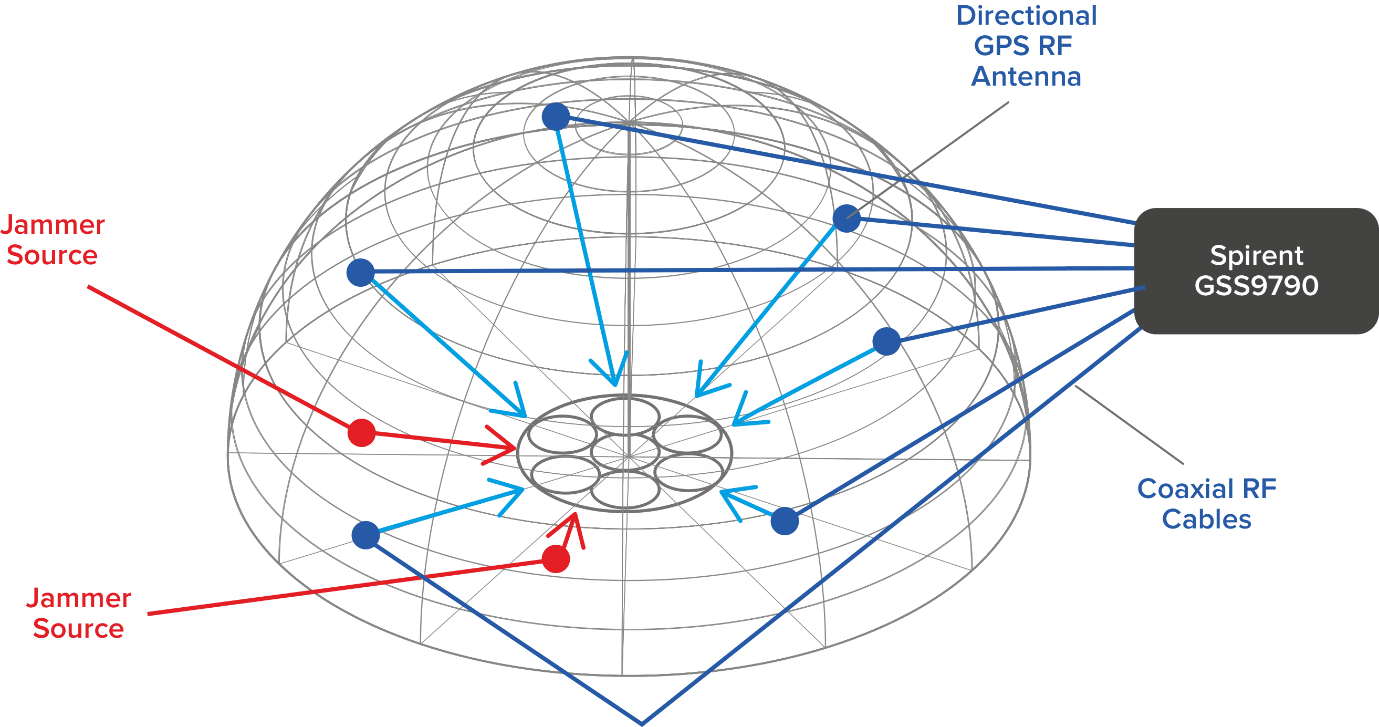
Spirent’s GSS9790 multi-output, multi-GNSS RF constellation wave-front simulator will be used as the signal generator attached to multiple transmission antennas for broadcast into the chambers.
Within this design, the antennas are structurally distributed to represent the correct arrival vectors of the simulated satellite signals on the device under test, creating the most realistic test environment possible. In addition, the GSS9790 supports interference sources located anywhere in the chamber to imitate different threat scenarios.
Image: Spirent
“Interference can threaten GNSS signals in multiple ways,” explained Jeff Martin, VP Sales. “We recognize the need for controlled, repeatable conditions to combat these threats. The GSS9790 delivers all the tools needed to successfully mitigate them.”
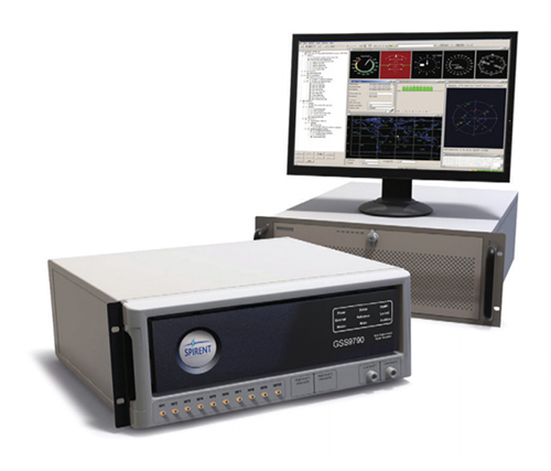
The GSS9790 simulator. (Photo: Spirent)
The Spirent GSS9790 supports classified Y-code, SAASM and M-code and can be found in key government labs across the country.
The Spirent GSS9790 enables verification of CRPA systems, spatial testing of single-antenna devices, and real-world-time-synchronized indoor GNSS implementations. The system is a development of the Spirent GSS9000. Combined with Spirent’s SimGEN software, it offers a powerful test platform for anti-jam and interference testing.
The U.S. military selected Orolia Defense and Security to supply multiple BroadSim advanced GPS simulator systems, a contract valued at $1.7 million (USD), in an effort to upgrade testing facilities and field test assets.
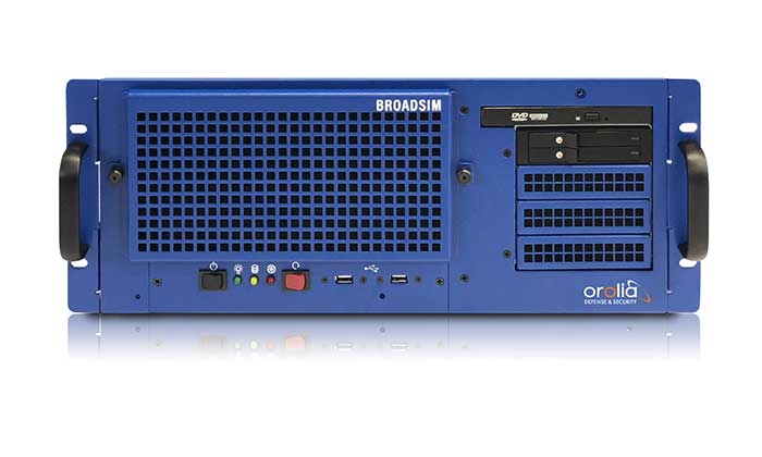
The BroadSim Advanced GNSS Simulator (Photo: Orolia)
These new simulator systems will enable better testing of widely deployed military GPS receivers, which are integrated into air and ground-based positioning, navigation and timing (PNT) systems.
BroadSim will be leveraged with Orolia’s Panacea test suite, which the U.S. military uses to conduct automated testing and analysis for PNT system performance and vulnerabilities.
BroadSim will bring versatility to the testing process by supporting diverse test methods and environments such as a laboratory setting, or an over-the-air (OTA) field test event.
BroadSim was selected based on its flexibility to support the ever-changing military tasks at hand, according to Orolia. It can be easily configured to support laboratory testing one day, and field testing the next with its four independent RF outputs, removable drives, and software-defined architecture.
“Equipping our actively deployed warfighters with state-of-the-art technology is of utmost importance and can mean the difference between mission success and failure. To help achieve that goal, Orolia’s GPS testing and simulation solutions ensure that these systems are battlefield ready,” said Tyler Hohman, Orolia Defense and Security’s director of products.
Orolia will host a webinar on this topic on Thursday, July 16, at 2 p.m. EDT, titled “PNT Vulnerability Testing for Critical Infrastructure:Lessons Learned from Defense.”
The federal government considers PNT to be a critical aspect of mission success, as outlined in the C4ISRNET white paper “Protecting the U.S. Military PNT Advantage from GPS Jamming and Spoofing” and defined in the PNT Executive Order. For the 2021 federal fiscal year, the U.S. Army alone budgeted more than $275 million towards Assured PNT Research, Development, Test & Evaluation (RDT&E), as published in the 2021 Defense Budget.
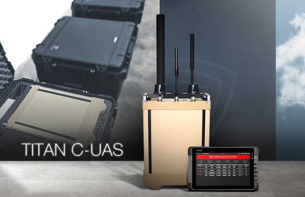
Titan C-UAS systems are deployed globally, protecting combat forces, civilians, and critical infrastructure. (Photo: Citadel Defense)
U.S. military, government and international customers opt for Citadel’s Titan for drone protection
Citadel Defense continues to experience rapid growth after being awarded several significant Defense and Homeland Security contracts for its C-UAS (counter unmanned aircraft systems) solutions.
Malicious drone activity, ranging from single-use hostile small unmanned aerial systems to drone swarms continue to threaten safety and national security. Over the past 18 months, Citadel has received orders for more than $17.5 million in products and services to support anti-drone initiatives around the world.
According to the company, the growth is a direct result of delivering reliable and effective force protection against individual drones and swarms for military, government and international customers over the past two years.
Citadel Defense’s automated counter drone solution uses artificial intelligence and machine learning as a reliable and scalable approach for addressing emerging threats.
To address the surge in global demand for Titan systems, Citadel has expanded its manufacturing capabilities in San Diego, California, to support production of up to 50 Titan systems a month. The company uses U.S. suppliers with more than 70% of components being sourced locally in Southern California to improve responsiveness when executing on urgent customer requests.
As new drones are released to the market, Titan systems receive new software to address the new threats. If Titan’s AI algorithms do not detect the threat right away, the company explained that it can deliver an end-to-end capability in 72 hours for most drones and less than 4 weeks for the most complex drone signals.
The use of AI, deepnets and adaptive countermeasures provide Titan with scalable force protection that can address the needs of the small unit, a large base or A mobile vehicle. The Titan system is being effectively integrated into layered solutions that combine radar, optics and kinetic countermeasures to help customers detect, identify, track, defeat and report on threat sUAS.
“Designing agility into our product development process from the beginning has allowed us to iterate in real-time alongside our customers and rapidly deploy new capabilities to improve mission outcomes,” said Christopher Williams, CEO of Citadel Defense.
As radiofrequency-based solutions become an important requirement for layered C-UAS solutions, Citadel has had its capabilities extensively evaluated by U.S. Army, Navy, Air Force, SOCOM, and DHS Test & Evaluation teams. Titan is being used to protect high-value assets in urban, rural and maritime environments.
“Designing our system to meet unpredictable mission scenarios was made possible by direct feedback from operators experiencing drone incursions on the front lines,” explained Williams. “The threat environment is always evolving which requires a product development approach that can adapt and respond. A combination of human-centered design and AI-powered technology have helped Citadel differentiate ourselves from traditional defense contractors.”
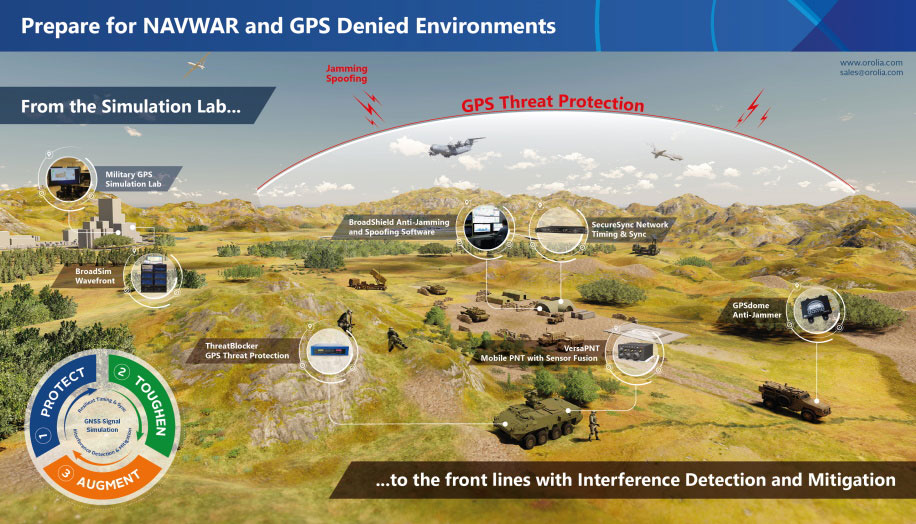
Resilient positioning, navigation and timing (PNT) company Orolia has nearly tripled new U.S. military orders for specialized resilient PNT solutions in the third quarter of 2019, the company stated in a press release.
Orolia said its solutions are helping to meet growing military demand for assured operations in Navigation Warfare (NAVWAR) and GPS-denied environments.
In the third quarter, Orolia unveiled its new Simulation and Interference, Detection & Mitigation (IDM) suite, announced the acquisition of GNSS simulation company Talen-X and introduced new advanced GNSS jamming and spoofing countermeasures.
The new U.S. military orders include the full range of Orolia’s resilient PNT solutions.
“This rapid industry response affirms Orolia’s commitment to delivering trusted military solutions for GPS denied environments,” said Paul Zweers, Orolia vice president of sales and marketing.
Soldier-borne sensors, leader-follower cargo-hauling technology and tiny, handheld unmanned aircraft are in the forefront of new technologies planned for U.S. warfighters, according to Maj. Gen. Robert M. “Bo” Dyess. The deputy director of the U.S. Army Capability Integration Center told AUVSI’s Unmanned Systems Defense keynote audience that developing tools and systems demanded by soldiers is key. He cited a recent demonstration exercise, in which soldiers responded enthusiastically to small, backpackable UAS that would let them see over the next hill or fence.
The Army is also developing autonomous ground systems including an unmanned combat vehicle, fully autonomous convoy operations and swarming unmanned aircraft. Autonomous weapons are seen as key in combatting both relatively low-tech guerilla and militia groups as well as high-tech “near-peer” combatants from organized industrial powers. A contested electromagnetic spectrum is emerging as a critical battlefield in the contemporary and future warscape, Dyess said. Cyberspace, racked by fundamental threats of spoofing, jamming and hacking, becomes the new killing ground.
Shad Reese, Tactical Warfare Systems, Unmanned Vehicles coordinator for the Office of the Undersecretary of Defense, said DoD is elaborating a new unmanned systems roadmap, which should be published in the first quarter of 2017. The roadmap will cover the period 2016-2041.
Reese said that a key aspect of the new roadmap is swarming technology, although at present there is little work underway in industry to support this. “Everyone and their mom is talking about swarming, but if you step back and look at what’s going on in industry, there are no real players in industry working on swarming.” Some work is underway in academia, but “we would like to have commercially available swarming technology.”
The Army’s squad mission support transport robot (SMET).
Army’s Ground Robots
The Army has put a robotic vehicle, the squad mission support transport robot (SMET), designed to carry heavy loads for troops, into an accelerated acquisition program. SMET is a 1,000-lb. tracked or wheeled platform carrying rucksacks, water or ammunition. A SMET version was recently tested in Afghanistan.
An Army spokesperson said the SMET has also been chosen as a pilot program a new way to do acquisitions that could shave time off development and fielding of new technologies, with industry involved from the start in specifications and requirements.
Swarms
Hordes of flying, thinking armed robots that autonomously coordinate amongst themselves, altering attack strategies in mid-mission and pushing through to strike targets kamikaze-style, are also seen as critical to future combat. The Air Force Research Laboratory calls the tactical weapons “distributed collaborative systems.”
Three drones work together to beam back information about an enemy’s location, and blocks their radar signals. (Image: DARPA)
The Air Force seeks to put “that next level of decision making and capability on the platform. Not only can it maintain itself, but it can work other parts of the team, whether those be airmen, or whether those be other machines to perform a mission task.”
Swarming micro-drones can be “really fast, really resistant. They can fly through heavy winds and be kicked out the back of a fighter jet moving at Mach 0.9, like they did during an operational exercise in Alaska last year, or they can be thrown into the air by a soldier in the middle of the Iraqi desert.”
“Swarming is a way to gain the effect of greater intelligence without each individual unit needing to be intelligent,” added one strategist. Last year Gen. Ellen Pawlikowski, commander of the Air Force Material Command, called swarming drones “very much a game-changing reality for our Air Force in the future.”
One consultant added that a human operator may not be able to compete with a fully autonomous system that identifies, analyzes and geolocates a target, especially in such a scenario where the swarm is moving rapidly. “The power and the sheer speed of execution would give them a huge advantage over their adversaries.”
Kristen Kearns, autonomy portfolio lead at AFRL, said that a major challenge with any autonomous system is verifying and validating that the decisions it is making are correct. Trust, or “verification and validation,” becomes paramount with artificial intelligence, Kearns added. “How do we assure safe and effective operations when we put decision making in the platforms?”
Steve Walker, deputy director of DARPA, said his agency has been working on developing battle management systems with a blend of manned and unmanned vehicles. “You have humans and unmanned systems and you need data fused together quickly and things are happening fast and you don’t want to overload the human with all that information. … You want to give him or her exactly what he needs to make a decision and have all these distributed effects work together,” he said.
One official noted the presence of many YouTube videos demonstrating robots flying, sailing or moving in formation. “It’s a good illustration of how so much of the advancement in this space is happening outside the defense world.”