Tag: UAV application

  • Harxon exhibits positioning, data-transmission tech at AUVSI Xponential

    Harxon exhibits positioning, data-transmission tech at AUVSI Xponential

    Harxon showcased high-precision positioning GNSS antennas and its latest wireless data-transmission technologies for UAV applications at AUVSI Xponential, which was held April 30-May 4 in Denver.

    The Harxon D-Helix Antenna.

    Harxon’s D-Helix is a patented D-QHA (dual-quadrifilar helix antenna) multi-constellation antenna supports excellent reception of GPS, Galileo, BeiDou and GLONASS, as well as L-band signals. Harxon D-QHA technology ensures the ability of low elevation satellites tracking while maintaining 4-dBi high gain, which makes the D-Helix antenna an excellent choice for any applications where the sky is partially visible, the company said.

    The antenna’s low noise amplifier (LNA) with out-of-band rejection performance can suppress electromagnetic interference. Moreover, the D-Helix features the latest low wind resistance design with ruggedized IP67 protection for UAV inspection and monitoring, survey and mapping or agricultural UAVs.

    Photo: Harxon
    Photo: Harxon

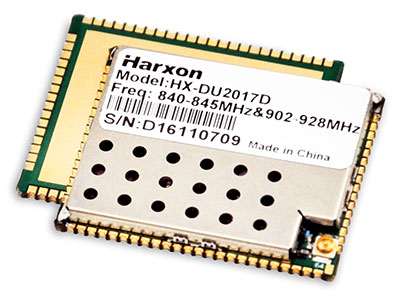
    The HX-DU2017D is a 5-gram frequency-hopping OEM transceiver supporting frequencies between 840 MHz and 900 MHz. It provides strong anti-jamming and signal receiving capability for complex data intensive applications. Its full duplex mode ensures data secure transmission, more stable long-range communication and short latency of data transmission.


    Watch this video to learn more about the HX-DU2017D.


    Other showcased Harxon GNSS products, such as Helix Antenna HX-CH7603A, HX-CH4601A and HX-CH6601A, are all featured with patented D-QHA technology. Moreover, the showcased Survey Antenna GPS 500, OEM Modem HX-DU1018D and Smart Antenna are also appropriate for surveying and mapping, as well as precision agriculture.

    Photo: Harxon
    Photo: Harxon
  • European Drone Summit to take place as part of Intergeo 2018

    European Drone Summit to take place as part of Intergeo 2018

    The first European Drone Summit will take place Oct. 15 in Frankfurt, Germany, to bring together stakeholders to discuss the future of drones in Europe. The summit is sponsored by UAV DACH e.V. and Interaerial Solutions of Intergeo.

    In addition to being a smart, up-and-coming technology, commercial drones are also an integral part of the digitalisation of business and society. The EU member states have agreed to introduce legislation regulating the operation of unmanned aircraft in Europe that takes into account both economic potential and safety requirements.

    The programme will be put together by UAV DACH experts and will explore legal aspects, technological issues and various application areas. Legislators, industry representatives and user groups will meet on the eve of Europe’s largest trade fair for commercial drones.

    The following experts will speak (with more to be named later):

    • Peter van Blyenburgh, UVSI
    • Max Scheck, Vereinigung Cockpit
    • Jules Kneepkens, EASA a.D.
    • Martin Brandenburg, DJI
    • Andreas Lamprecht, AIRMAP
    • Jörg Seebach, DeDrone

    UAV DACH is an association for commercial unmanned aviation in Europe. It represents the interests of 175+ corporate members from research, manufacturing and application located in Germany, Austria, Switzerland, Italy, Spain and the Netherlands.

    The Interaerial Solutions part of Intergeo is the largest commercial drone trade fair in Europe. It takes place Oct. 16-18, also in Frankfurt.

  • UAV Design and Applications: Autonomous Relative Navigation and GNSS Robustness for UAV Systems

    Broadcast Date: May 19, 2016
    On-Demand Available Until: May 19, 2017
    Sponsor: Septentrio
    Summary: Constantly evolving, it’s no wonder keeping up on the latest in UAV design and applications can be challenging. In this webinar, speakers will engage you in discussions involving self-generated radio-frequency interference aboard UAVs; an autonomous relative navigation tool for in-air UAV refueling; sensor integration for a UAV designed for industrial environments; and considerations for multi-GNSS integration onto UAV platforms.
    Speakers: Dennis Akos, Professor, University of Colorado at Boulder; Joshua Stubbs, Recent Graduate, MS, Luleå University of Technology; Jeffrey Fayman, CTO, Geodetics; Chris Miser, CEO, Falcon Unmanned; and Jan Leyssens, Product Manager, Septentrio