Tag: Uganda

  • Seen & Heard: Google’s scammer takedown, Harvard’s free navigation history course and more

    Seen & Heard: Google’s scammer takedown, Harvard’s free navigation history course and more

    “Seen & Heard” is a monthly feature of GPS World magazine, traveling the world to capture interesting and unusual news stories involving the GNSS/PNT industry.


    Free navigation history course

    Photo: Harvard University
    Photo: Harvard University

    Harvard University offers PredictionX: Lost Without Longitude, a free online course that examines the evolution of navigation from ancient methods to modern technologies. The program explores the science and history of navigation, focusing on the challenges of determining longitude before GPS existed. It highlights key advancements, such as John Harrison’s marine chronometer and the Longitude Prize. Through multimedia content — including videos, infographics and Worldwide Telescope tours — the course is designed to demonstrate how centuries of advancement in navigation enabled humanity to achieve milestones such as landing on the moon.

    Self-driving cars collect geospatial data

    Photo: Finnish Geospatial Research Institute
    Photo: Finnish Geospatial Research Institute

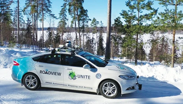
    In Finland, self-driving cars are being used to collect geospatial data to address urban challenges. The ARVO autonomous vehicle from the Finnish Geospatial Research Institute is equipped with high-precision sensors that map its environment in real-time, collecting information on road conditions, urban vegetation as carbon sinks and factors influencing flood risks. In partnership with Aalto University and funded by the European Regional Development Fund, this initiative seeks to explore various uses of this data, such as city planning, environmental monitoring and infrastructure management.

    Stopping scammers

    Photo: Carlos Alvarez / iStock Editorial / Getty Images Plus / Getty Image
    Photo: Carlos Alvarez / iStock Editorial / Getty Images Plus / Getty Image

    Google has taken legal action against a network of scammers responsible for creating more than 10,000 fake business listings on Google Maps. The scammers fabricated profiles targeting urgent service industries and bolstered them with fake reviews to appear credible. Victims were misled into contacting these fake businesses, which then sold their personal information as “leads” to legitimate service providers without consent. Google has removed the fake listings and is suing individuals involved in the scheme, CBS News reported.

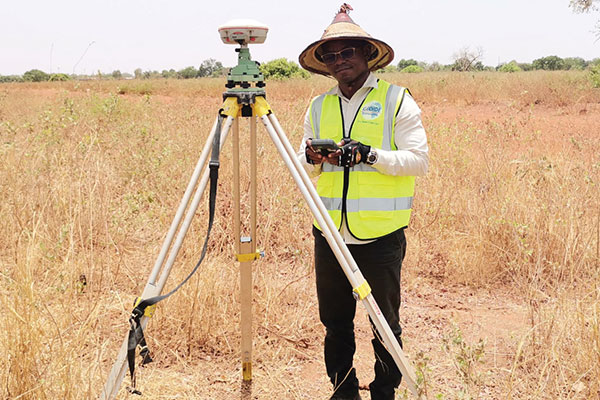
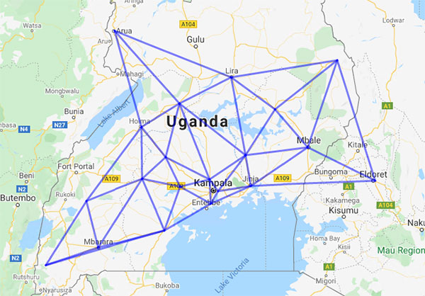
    Mapping Uganda’s disappearing tropical glaciers

    Photo: guenterguni / E+ / Getty Image
    Photo: guenterguni / E+ / Getty Image

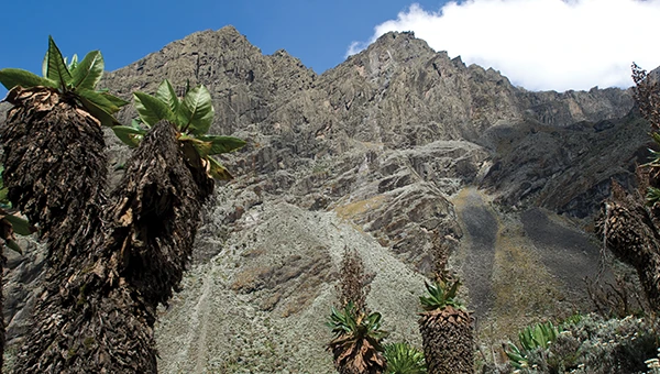
    Project Pressure, in collaboration with UNESCO and the Uganda Wildlife Authority, conducted an expedition to the Rwenzori Mountains to map the region’s disappearing tropical glaciers. The team created the first 3D model of Mt. Stanley’s glaciers and installed monitoring equipment, revealing that Mt. Speke and Mt. Baker have lost their glaciers entirely, while the Stanley Plateau Glacier has shrunk by 29.5 percent since 2020 and is heavily fragmented. The project aims to continue monitoring the glacial retreat, develop mitigation strategies and engage the local community in ongoing research.

  • ComNav helps bring GNSS benefits to Africa

    ComNav helps bring GNSS benefits to Africa

    ComNav Technology Ltd. is providing GNSS technology to Africa for projects in land mapping, continuously operating reference station (CORS) construction, precision agriculture and other fields, according to a Feb. 11 article in People’s Daily, the largest newspaper in China.

    Every day, thousands of users in Africa are using GNSS products, the newspaper stated, highlighting specifically the use of China’s BeiDou satellite navigation system. For instance, CORS using ComNav GNSS/BeiDou receivers have been built in 11 sub-Saharan African countries, including Kenya and Uganda.

    Uganda. To meet the demand for high-precision GNSS, the government of Uganda purchased ComNav’s real-time kinematic (RTK) receivers to build its own CORS. Thirty stations have been built so far, creating the most advanced CORS network in East Africa. Its high-precision spatial and temporal information supports land mapping, mining, vehicle management and meteorological monitoring, among other industries.

    In 2015, Mulindwa David, chairman of the Uganda Surveying Association, and others visited the Shanghai headquarters of ComNav to learn about its high-precision products and technologies. After training, David and others mastered basic RTK operation and learned simple maintenance.

    David used to carry heavy optical equipment every day, but now he only needs to hold a BeiDou receiver to process the relevant data, which has greatly improved his work efficiency and accuracy. “It took at least three days to survey a dozen kilometers of road with optical equipment,” he said. “With BeiDou high-precision receivers, only 10 hours is enough.”

    The Uganda CORS network. (Image: ComNav)
    The Uganda CORS network. (Image: ComNav)

    Burkina Faso. In response to the COVID-19 outbreak, the Burkina Faso government decided to build a hospital for infectious diseases. In April 2021, it used ComNav GNSS high-precision technology to provide survey data for the hospital’s construction. The land security and topographic surveying tasks were completed in six days, half the time scheduled, said Augustin Bamouni, secretary-general of the country’s national surveying association.

    A surveyor in Burkina-Faso surveys the site of a new hospital for infectious diseases. (Photo: ComNav)
    A surveyor in Burkina-Faso surveys the site of a new hospital for infectious diseases. (Photo: ComNav)

    Tunisia. The China-Arab BeiDou/GNSS Center is located in the Ghazara Science Park in northern Tunis, the capital of Tunisia. Inaugurated in 2018, it is China’s first overseas BeiDou center, providing satellite navigation training, test evaluation and technical research for African and Arab countries. On average, the center receives real-time data from more than 12 BeiDou satellites at once.

    The center will help Tunisia and other African countries train professionals in GNSS technology to support development of the digital economy, according to Amiri Khalil, state secretary in charge of scientific research at Tunisia’s Ministry of Higher Education.

    China-Arab Beidou/GNSS Center is in Tunis, Tunisia. (Photo: ComNav)
    China-Arab BeiDou/GNSS Center is in Tunis, Tunisia. (Photo: ComNav)

    China-Africa Forum. The first China-Africa BeiDou System Cooperation Forum was held in November 2021 in Beijing to encourage cooperation between China and Africa and promote use of BeiDou. Four cases from ComNav Technology were described in the forum’s document citing application scenarios of BeiDou in Africa.

    ComNav Technology has deepened its cooperation with Africa since China’s Belt and Road Initiative began in 2013. Besides providing products and technologies, ComNav arranged employees to go abroad to provide technical support, traveling to Cameroon, Nigeria, Mali, Zambia, and other African countries. Despite the pandemic, ComNav continues to provide professional service and training both in person and remotely.

  • On the Edge: Sharing GNSS Wealth

    Workshop participants from Cote d’Ivoire and Kenya assemble a Mindstorm robot to trial autonomous navigation.
    Workshop participants from Cote d’Ivoire and Kenya assemble a Mindstorm robot to trial autonomous navigation.

    By Patricia Doherty

    Last year I helped coordinate a three-week workshop for 50 scientists from 15 African countries, introducing the basics of GPS for applications with socioeconomic benefits and scientific exploration. Held in Trieste, Italy, the workshop was quite successful, producing new initiatives on the African continent. We repeat the workshop next month, 
April 6–24, again in Trieste.

    Since the 2009 training, regional GNSS workshops have taken place in Nigeria, Egypt, Kenya, and Ethiopia. We have initiated scientific collaborations with universities in Nigeria, Kenya, Zambia, Egypt, and Uganda, deploying GPS receivers at each institution, with the understanding that the data will ultimately be shared within Africa and the world.

    This effort is a way to share with Africa and Africans the wealth that GNSS has brought to the developed world.

    Africa’s 2006 Science and Technology Plan of Action states Africa’s commitment to develop and use science and technology for socio-economic transformation and full integration into the world economy. The leading problems that continue to cripple much of Africa include hunger, extreme poverty, erosion of natural resources, and natural disasters. GNSS can help address these problems and ultimately meet the plan’s goals. Specifically, GNSS applications can increase food security, manage natural resources, provide efficient emergency location services, improve surveying and mapping, and provide greater precision and safety in land, water, and air navigation systems. GNSS also has applications in scientific study including space weather, geophysics, geography, geology, ecology, and biology.

    Workshop participants included professors and graduate students from Cote d’Ivoire, Egypt, Ethiopia, Ghana, Kenya, Morocco, Nigeria, Uganda, and Zambia. The more than 25 lecturers came from the United States, Europe, and Africa.

    Edge-2The workshop integrated formal lectures with hands-on practice in GNSS architecture, signal structure, hardware design, state-of-the-art applications, and scientific exploration. An on-site computer laboratory enabled participants to perform positioning calculations; use mapping and surveying software; plan a precision farming procedure; and analyze atmospheric and ionospheric data — all from GPS measurements. In addition, participants built Lego Mindstorm robots to demonstrate autonomous navigation.

    One of the benefits of this program was that scientists and engineers from the United States had opportunities to discuss common interests with African scientists and engineers. Many research programs utilize GPS ground- and space-based measurements. Unfortunately, studies over the African region have not been possible due to the lack of dependable long-term measurements. This workshop opened the door to establishing a base of measurements for joint studies with our African colleagues.

    Many lecturers remarked that this was the most enriching teaching experience of their careers. The African participants said that they learned a great deal and were very appreciative of the opportunity to participate in this program.

    Workshop sponsors include Boston College’s Institute for Scientific Research (where I work), the Abdus Salam International Center for Theoretical Physics in Trieste (where my colleague and workshop co-director Sandro Radicella is head of the Radiopropagation Laboratory), Institute of Navigation, Federal Aviation Administration, Air Force Research Laboratory, National Aeronautics and Space Administration, United Nations Office for Outer Space Affairs, National Science Foundation, Trimble, and NovAtel.

    To learn more about the workshop, participate, or contribute, please contact Patricia.Doherty @ bc.edu