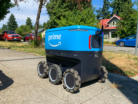
On university and business campuses, getting lunch and dinner is becoming a lot easier as robot delivery units hit the pathways.
If you were a student or faculty member at the University of Wisconsin – Madison campus (UW) during the 2020 COVID lockdown, you might have experienced a novel way to reduce contact with others when ordering a meal. People on campus could avoid a trip to the store and interaction with a delivery person. They could place an order on a special app, and a Starship Technologies robot would pick up and deliver their food.
Of course, for a student, technology that saves a trip to the store, especially anytime of the day or night, would be popular.
From demo to full production
At first, the meal-delivery robots at UW and other campuses were a demonstration to showcase how useful the small bots could be.
But after I soaked up robot-tech news from all over, I learned these little guys have found their way into towns, cities and campuses around the world: specifically, the United States, United Kingdom, Estonia, Germany and Denmark.
With 1,500 bots working every day, the demonstration phase is long over, and Starship robots are full production. Starship, based in San Francisco, has been in operation since 2014. Its robots now make more than 1,000 deliveries each day. They have made more than 2.5 million deliveries to date, and make 100,000 road-crossings each day.
In the United States alone, 16 states have approved delivery robots, including Virginia, Idaho, Wisconsin, Florida, Ohio, Utah, Arizona, Washington and Texas. At UW, three Starship employees manage maintenance and recover units if they get stuck (while autonomous, the bots need help every now and then).
To have a robot come to visit, UW users download the Starship Food Delivery app, select from a local store menu, pay and then indicate on a map exactly where the bot should deliver the order. The robot collects a minimal $2 delivery charge, which goes toward the $2,000 to $3,000 cost of the vehicle and its operation. (According to Starship, each unit costs the equivalent of a high-end laptop.)
The unit uses GNSS and computer vision to navigate detailed, stored maps. The on-site employees take the robots out on particular routes for their first test runs, and the bot learns each route. The on-board system also uses 12 cameras, ultrasonic sensors, radars and neural networks to form a collision-avoidance net around the vehicle. In this way, pedestrians, dogs and road vehicles (when the robots cross a road) can all be avoided.
When waiting to cross a road, the robot’s safety systems might prevent it from moving. In this case, the device will “phone home” for a support person come out and fix the issue.
What could go wrong?
So far, the robots have been welcomed on the university and industry campuses where they operate. People walk round them as they go about their business. Even better, students and other users have pulled the units out of snow mounds and other hang-ups, returning them to the sidewalk or making other small adjustments to send the bots on their way.
And no one has stolen a unit. That could be because a loud siren erupts if they are picked up. Presumably the units are programmed to remain within the bounds of their rigorously mapped environments. In any event, the food compartment remains locked until the order is removed by the customer.
Disrupting Doordash
Will robots disrupt today’s car-based delivery services, such as UberEats, Grubhub or DoorDash? Only for the last-mile section of a delivery. In a pinch, Starship robots can travel as far as three miles from their base. As the bots take on more territory, the auto-based delivery companies may be pushed toward the longer routes.
Deliveries such as time-sensitive medical materials could benefit from robotic short-distance, small-package carriers. Other robot delivery services, including Amazon Scout and Roxo, the FedEX SameDay Bot, are also making waves as testing progresses toward last-mile delivery automation from warehouse hubs to customer homes.
Federal, state and local laws may need to be enhanced to allow these autonomous delivery robots to progress toward widespread deployment.
One selling point: Fast robot deliveries lead to fewer delivery trucks, reducing traffic congestion and lowering exhaust pollution. We might have to wait awhile to realize these benefits.
Tony Murfin
GNSS Aerospace
Feature photo: Cindy Shebley/iStock Editorial/Getty Images Plus/Getty Images