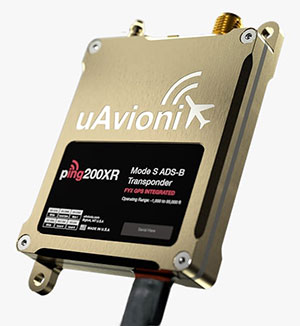
uAvionix has added a new low-SWaP transponder to its line-up of unmanned aerial system (UAS) communications, navigation and surveillance solutions.
The ping200XR integrates the capability of the ping200X TSO Certified Mode S ADS-B OUT transponder with the high-integrity truFYX TSO-certified GPS position source into a single enclosure. The single enclosure simplifies installation and allows the customer to choose between the existing installed GPS antenna or one provided with the ping200XR.
The integrated GPS ensures maximum safety by providing Source Integrity Level (SIL) 3 RTCA DO-229D and TSO-C145e Class Beta 1 performance, a requirement for Mode S and ADS-B airspace access, and for reception and processing by certified avionics and Traffic Collision Avoidance Systems (TCAS) in other aircraft, as well as Air Traffic Control (ATC). SIL 3 performance is not available from non-aviation certified GPS, which are often used as an autopilot navigation source.
The ping200XR can be integrated with popular onboard UAS autopilots for dynamic control from ground-control stations, including George — uAvionix’s enterprise autopilot solution. The ping200XR can also be pre-configured before flight and carried as a payload.
Replicating the functionality of a cockpit transponder controller, the uAvionix mini-controller allows users to dial-in a squawk code before takeoff for even quicker integration and rapid deployment.
In September 2019, the Xinjiang Institute of Ecology and Geography conducted a nine-day project on the Heishan Mining Zone in Toksun County, Xinjiang Province, China.
The CHCNAVBB4 UAV was combined with the AlphaUni 900 lidar solution to capture data and produce a topographic map of the mining area at a scale of 1:500. The point-cloud data was collected for subsequent 3D modeling to facilitate asset management and inventory work.
In another project, CHCNAV provided training and equipment for a China Railway No. 10 Engineering Bureau project. For this project, CHCNAV’s BB4 UAV was combined with the AlphaUni 1300 lidar system and deployed to study the topography of the tunnel mouth in Liangshan, Sichuan province.
The BB4 is a high-end unmanned aerial system resulting from an alliance between the two companies in their respective segments. Its scientific design and highly integrated production technology come from CHCNAV — a global manufacturer specialized in efficient geospatial measurement technologies — and its fully automated flight control system from DJI, pioneer in the manufacture of commercial UAVs.
The AlphaUni 900 and AlphaUni 1300 are high-end multi-platform lidar systems, designed and improved by CHCNAV through many years of exploration and data-capture experience. Both are fully integrated systems with high-precision, long-range laser scanners that provide unique waveform lidar technology from Riegl and a high-accuracy inertial navigation system.
The AlphaUni systems can take on demanding surveying missions in the air and on the ground that require the highest quality of data.
Trimble continues to increase its footprint to deliver high-accuracy positioning correction services
Photo: Trimble
Trimble has acquired MidStates VRS, a network previously owned by Butler Machinery and Frontier Precision. The addition of the network, in North and South Dakota, increases the footprint of Trimble’s VRS Now GNSS corrections service to cover more than one million square miles in North America. Financial terms were not disclosed.
As part of an ongoing expansion strategy, the new coverage for the VRS Now subscription service helps users in more places achieve high-accuracy positioning to increase productivity, reduce operational costs and improve safety.
The correction service is designed for professionals in agriculture, geospatial and construction as well as emerging autonomous applications including lane-keeping for passenger vehicles, vehicle-to-everything (V2X) position identification and unmanned aerial system guidance.
Adding 105,000 square miles of coverage, the acquisition expands Trimble’s VRS Now network to be one of the largest in North America — over one million square miles, contributing to Trimble’s shift toward a software, services and subscription business emphasis.
When using the Trimble VRS Now service, land and construction surveyors, GIS professionals and farmers — with a Trimble or third-party commercial GNSS receiver — can leverage instant high-accuracy corrections delivered via cellular network to improve productivity.
Enabling users to work without a GNSS base station, the service is cost-effective and simple to use. It is ideal for a variety of applications that require sub-inch level accuracy and is an important component of the connected construction site and connected farm workflows.
“The MidStates VRS network covers significant farmland, oil fields and rapidly developing urban areas, providing farmers and surveyors in the region with the real-time GNSS correction services they need to improve their day-to-day work,” said Patricia Boothe, senior vice president of Trimble’s Autonomy Sector. “The purchase of the MidStates network demonstrates Trimble’s ongoing commitment to provide a wide range of correction services for autonomous solutions — delivering unmatched access to fast, reliable and highly accurate positioning in more areas than ever before.”
Trimble networks are supported by a global network operations team made up of GNSS system engineers, geodesy experts and IT professionals. The team monitors the networks 24/7 from operation centers located on three continents, providing consistent and reliable service uptime and performance integrity.
Trimble VRS Now. The correction service offers instant access to centimeter-level positioning tailored to the users’ geographic location; the service is always on wherever and whenever needed within the network coverage area. With no base station or setup required, it is cost-effective, efficient and simple to use.
VRS provides positioning professionals with instant access to real-time kinematic (RTK) and post-processing (PP) corrections utilizing a network of permanent (fixed) continuously operating reference stations (CORS).
Trimble-owned VRS networks are accessible now in areas throughout the U.S. and Canada as well as Eastern Australia and Tasmania, France, Belgium, the Czech Republic, Estonia, Germany, Great Britain, Ireland, Luxembourg, the Netherlands, Sweden and New Zealand.
An electric cooperative that serves more than 33,000 member customers in Lakeside, Arizona — including the White Mountain Apache Tribe — is using an unmanned aerial system (UAS) to enhance the utility’s GIS effort, working with UAS specialist Skynetwest. Noah Ruiz started Skynetwest in 2015 to provide aerial photographic and videographic services, but seeing the potential of UAS he began making the pivot to high-value data retrieval.
Initial work for the Navopache Electric Cooperative (NEC) included an inspection of an area’s substations. Conducted on a day in which the winds were blowing at 20+ mph, with most other aircraft, the flight would have been extremely risky if not scrapped.
Skynetwest used an Intel Falcon 8+ Drone, Topcon Edition. Windspeed limits for the Falcon 8+ in GPS mode are set at 26 mph; in height mode that threshold is extended to windspeeds as high as 35 mph.
The Falcon 8+ has triple-redundancy inertial measurement units (IMUs), double-redundant compasses, dual-constellation GPS, eight propellers and two batteries. Built into the aircraft’s software is an algorithm that detects the electromagnetic frequencies coming off of power lines and tells the IMUs which one it wants to switch from, which GPS it wants to use, and which compass it wants to use.
The aircraft’s stability is key not only for power line work but also for items like inspection of oil and gas components. For inspection applications — close-up inspections to detect millimeter-sized damage, fine hairline cracks, leaks or heat power losses, for example — the Falcon 8+ payload consists of a Panasonic Lumix DMC-ZS50 camera for true-color RGB images and the FLIRTau 2 640 thermal imaging camera for infrared imaging. The hybrid RGB + 14-Bit RAW data inspection payload combines a near-infrared camera with a high-resolution digital camera mounted in parallel.
The mapping package Skynetwest uses includes a 36-megapixel RGB camera (Sony Alpha 7R) and delivers both orthophotos and 3D models in Topcon ContextCapture software, powered by Bentley Systems.
Upon completion of the substation project, using ContextCapture and Agisoft PhotoScan software, Skynetwest stitched together all of the images it had gathered to create a georeferenced 3D model of that substation. NEC is looking into building more 3D representations of the entire grid and ultimately hoping to build a complete 3D spatial record down to nuts and bolts — all with survey grade data.
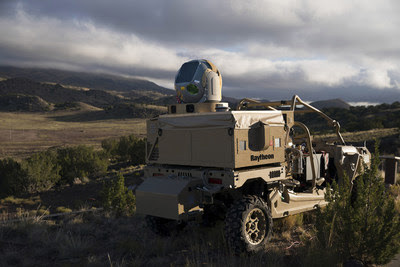
Raytheon Company‘s advanced high-power microwave and mobile high-energy laser systems engaged and defeated multiple unmanned aerial system targets during a U.S. Air Force demonstration. The mature HPM and HEL technologies offer an affordable solution to the growing UAS threat, the company said.
Raytheon made the announcement at AUVSI Xponential, taking place this week in Chicago.
Raytheon’s mobile high energy laser looks out into a wide-open sky. The company’s advanced high-power microwave and high-energy laser engaged and defeated dozens of unmanned aerial system targets in a recent U.S. Air Force demonstration.
The HEL system, paired with Raytheon’s Multi-Spectral Targeting System, uses invisible beams of light to defeat hostile UASs. Mounted on a Polaris MRZR all-terrain vehicle, the system detects, identifies, tracks and engages drones.
“Countering the drone threat requires diverse solutions,” said Stefan Baur, Raytheon Electronic Warfare Systems vice president. “HEL and HPM give frontline operators options for protecting critical infrastructure, convoys and personnel.”
Raytheon’s HPM uses microwave energy to disrupt drone guidance systems. High-power microwave operators can focus the beam to target and instantly defeat drone swarms. With a consistent power supply, an HPM system can provide virtually unlimited protection.
“After decades of research and investment, we believe these advanced directed energy applications will soon be ready for the battlefield to help protect people, assets and infrastructure,” said Thomas Bussing, Raytheon Advanced Missile Systems vice president.
Raytheon’s HEL and HPM were the only directed energy systems that participated in this Air Force experimentation demonstration. The event expanded on previous directed energy demonstrations such as a U.S. Army directed energy exercise held in 2017.
Grand Sky Business and Aviation Park and Harris Corp. have joined forces to enable the country’s first and largest unmanned aerial system (UAS) airspace to support beyond visual line of sight (BVLOS) flight operations and UAS Traffic Management (UTM) research.
Stretching up to 100 miles, this BVLOS “super corridor” is the most technologically sophisticated UAS airspace supported by multiple and redundant systems for cooperative and non-cooperative surveillance.
These surveillance capabilities make possible a wide range of UAS BVLOS applications in precision farming, oil and gas, infrastructure inspection, public safety, package deliveries, and others.
“Customers of Grand Sky will have access to a truly unique UAS operational capability, in addition to better facilities, comprehensive airspace surveillance, and wide operational areas,” Grand Sky Development Co. President Thomas Swoyer Jr., said. “We all benefit from efficient and safe BVLOS flight operations and a larger corridor with proven FAA collaboration and flight authorizations.”
The surveillance system combines data feeds from a network of advanced sensors and towers. Two long-range primary radars located at Grand Forks Air Force Base and at Hillsboro, North Dakota, provide detection of non-cooperative aircraft.
The Federal Aviation Administration (FAA) secondary radars and ADS-B network in the region, as well as local Harris ADS-B Xtend sensors, add additional layers of visibility for cooperative aircrafts in the airspace.
Aviation-grade displays help pilots and electronic observers monitor the airspace environment over the BVLOS corridor and safely steer UAS from approaching manned aircraft.
The combination of best practices in aviation safety management, proven technologies and experience with BVLOS regulatory approvals will make it easy for users of the airspace to advance UAS technology commercialization and routine, efficient flight operations.
UAS operators can work with Grand Sky and Harris to develop, test, and refine a variety of complex BVLOS concepts of operations and secure waivers from the FAA for large-scale use.
A full range of UAS operations can be supported for all types and sizes of unmanned aerial vehicles along the BVLOS corridor including a variety of airspace classes and execution of diverse defense, civil and commercial applications.
“This is another first for Grand Sky and North Dakota in leading the UAS Industry,” Harris Vice President and General Manager of Commercial UAS Solutions George Kirov said. “The size and complexity of the airspace opened to UAS BVLOS operations is unmatched in the UAS industry. The sophistication of the Harris BVLOS system at Grand Sky is also unprecedented — linking Harris’ most advanced suite of surveillance and detect-and-avoid services with a variety of surveillance assets that, together, ensure the highest level of UAS aviation safety.”
This partnership lays the foundation for larger and more capable surveillance corridors to enable UAS “highways” across the state of North Dakota and in support of expanding the variety of commercial UAS operations across the United States.
The U.S. Federal Aviation Administration (FAA) has released its annual Aerospace Forecast Report Fiscal Years 2016 to 2036, which finds a sustained increase in the use of unmanned aircraft systems (UAS) as well as overall air travel.
A key portion of the forecast focuses on projections for the growth in the use of unmanned aircraft, also known as drones. The FAA estimates small, hobbyist UAS purchases may grow from 1.9 million in 2016 to as many as 4.3 million by 2020.
Sales of UAS for commercial purposes are expected to grow from 600,000 in 2016 to 2.7 million by 2020. Combined total hobbyist and commercial UAS sales are expected to rise from 2.5 million in 2016 to 7 million in 2020.
Predictions for small UAS used in the commercial fleet are more difficult to develop given the dynamic, quickly evolving nature of the market. Both sales and fleet-size estimates share certain broad assumptions about operating limitations for small UAS during the next five years: daytime operations, within visual line of sight, and a single pilot operating only one small UAS at a time. The main difference in the high and low end of the forecasts is differing views on how those limitations will influence the widespread use of UAS for commercial purposes.
Looking at commercial air travel, Revenue Passenger Miles (RPMs) are considered the benchmark for measuring aviation growth. An RPM is one revenue passenger traveling one mile. The FAA forecast calls for system RPMs by mainline and regional air carriers to grow at an average rate of 2.6 percent a year between 2016 and 2036, with international RPMs projected to increase 3.5 percent a year, doubling over the forecast period. Domestic RPMs are forecast to increase by more than 50 percent over the same time. In 2015, system RPMs by U.S. carriers grew from 857 billion to 889 billion, a 3.8 percent increase.
The FAA’s NextGen program is helping to meet this consistent aviation growth. NextGen focuses on implementing technologies and procedures that utilize satellite-based aircraft navigation and phase out efficiency limitations of the current ground-based radar navigation system. For example, the environmental and economic gains of reduced fuel usage associated with NextGen advancements are projected to achieve a savings of billions of dollars in airline operational costs and achieve sustainable aviation growth.
Proven economic data that utilize sources such as generally accepted projections for the nation’s GDP are used in the FAA annual forecast, which has consistently made it the industry-wide standard of U.S. aviation-related activities. The report looks at all facets of air travel including commercial airlines, air cargo, private general aviation, and fleet sizes.
The Federal Aviation Administration (FAA) wants unmanned aircraft owners to know that there’s no need to work with a “drone registration” company to help them file an application for a registration number.
Owners should wait until additional details about the forthcoming drone registration system are announced later this month before paying anyone to do the work for them.
The Task Force assigned to provide FAA Administrator Michael Huerta with recommendations on the registration process is still days away from delivering this information. But at least one company is already offering to help people register their drones — for a fee.
Speaking to the Task Force two weeks ago, Administrator Huerta told the group to provide guidance on a streamlined unmanned aircraft registration process that will be simple and easy to complete, and which types of UAS would need to be registered and which would not. The Task Force agreed and is working on recommendations for a system that is similar to registering any newly purchased product with its manufacturer, as well as a minimum weight for unmanned aircraft that must be registered.
Drone owners should visit FAA.gov for official updates on the unmanned aircraft registry.
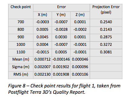
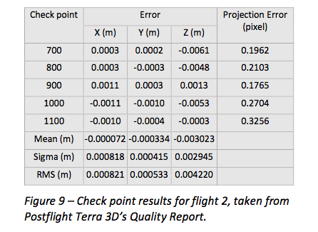
senseFly has published a white paper named “Generating highly accurate 3D data using a senseFly eXom drone” which presents the results of two photogrammetric land surveys of a construction site. The project was completed earlier in September using two senseFly eXom close mapping and inspection drones, and the announcement was made during INTERGEO, held Sept. 15–17 in Stuttgart, Germany.
The results demonstrate that 3D point clouds produced with an eXom quadcopter can reach a global precision comparable to that of a total station survey and meet the typical accuracy requirements of construction projects, according to a news release from senseFly.
The first eXom survey (figure 8) achieved 2.1 millimeter accuracy in X, 1.9 millimeter in Y and 0.1 millimeter in Z (RMSE). The second eXom survey (figure 9) achieved 0.8 millimeter (X), 0.5 millimeter (Y) and 4.2 millimeter (Z).
“This degree of absolute accuracy from a drone is unparalleled and positions the eXom as a surveying instrument that is comparable in performance to standard total stations,” said Andrea Halter, senseFly’s co-founder. “These results were due, in part, to the high 38 MP resolution and sharpness of the flight’s images, captured by the main camera inside eXom’s TripleView head. Add to this image quality the ability to operate close to the terrain and the introduction of highly precise ground controls and you have a recipe for exceptionally accurate 3D data.”
Two eXom drones flew separate survey missions at an altitude of 14 meters above the site, achieving an average ground sampling distance (GSD) of 2.2 millimeters, senseFly says. All the flights were completed using the drone’s Interactive ScreenFly flight mode, whereby the UAV (unmanned aerial vehicle) is controlled using a handheld ScreenFly controller connected to senseFly’s eMotion X flight planning and control software.
This flight mode’s “cruise control” feature, combined with its auto-trigger function, enabled each of the eXom drones to survey the 1,100-square-meter site in a single flight. Meanwhile, the live on-screen feedback from the drone’s five different navcams and ultrasonic proximity sensors helped the operator ensure that no contact was made with either the on-site crane or any the trees surrounding the complex site, senseFly says.
“This project’s flights took place at 14 meters above the ground, but with the eXom’s Distance Lock feature we are able to safely fly just 4 meters away, so it isn’t unrealistic to think that the accuracy we achieved could be improved still further.”
To download the eXom accuracy white paper click here.
Exelis has improved the way its CorvusEye 1500 wide-area airborne system processes and analyzes the vast amount of data it collects, which is crucial in helping customers make critical decisions, the company said.
CorvusEye 1500 is one of the programs Exelis is featuring at Association for Unmanned Vehicle Systems International’s (AUVSI’s) Unmanned Systems 2015 May 4-8 in Atlanta (booth #2449). From an altitude of 15,000 feet, CorvusEye 1500 provides color and infrared imagery of a city-sized area unavailable with comparable airborne systems. At Unmanned Systems 2015, visitors will see how users work with the real-time analytics and processed data to search for vehicle tracks based on location and time.
“It’s all about context,” said Dwight Greenlee, director, regional persistent surveillance, Exelis Geospatial Systems. “Conventional video surveillance systems with their ‘soda straw’ views can miss critical activities, making it hard to understand what’s happening over a wide area. CorvusEye now has real-time analytics that automate certain tasks. For example, users can set ‘watch boxes’ or ‘trip wires’ in as many as 10 areas of interest. Users are then alerted if anything moves in or out of that area, and they can automatically track that moving object. Because of the context provided by CorvusEye, users can be more confident in the data to make decisions.”
Another new capability in CorvusEye is the ability to cue a second sensor, such as a hyperspectral sensor, to scan a location for certain spectral “signatures” indicating the presence of a material or gas. Analysts also can easily integrate full-motion video sensors into the cueing capability.
Processing CorvusEye data post-flight provides analysts with a database of all moving objects in the entire scene, allowing them to gather critical forensic intelligence and enabling a better understanding of behaviors and patterns across the region.
At 15 inches in diameter and weighing less than 95 pounds, the CorvusEye turret and sensor package can fit on most midsize unmanned and manned aircraft and uses standard interfaces to swap into virtually any 15-inch airframe mounting location. CorvusEye is exportable to many military, intelligence and security customers around the world, Exelis said.
Christian Ramsey, UAS program manager for Exelis, explains that the Symphony RangeVue enables UAS (unmanned aerial system) operators and test range personnel to have access to both real-time and historical aircraft surveillance information via a web-hosted platform, helping to manage mission operations across multiple locations. Symphony RangeVue can be used as command center decision support and post-event analysis tool, or in the field as a sense-and-avoid addition to UAS ground control stations. Flexible geo-fencing tools alert operators when a UAS approaches airspace boundaries or other aircraft are in the vicinity.
Topcon Positioning Systems has received a national exemption from the Federal Aviation Administration (FAA) that allows for operation of its unmanned aerial system (UAS) in the United States. The exemption covers the operation of the Sirius Basic and Sirius Pro for aerial data collection.
The Sirius Pro and Sirius Basic systems are designed to produce accurate solutions for the automated mapping of a wide range of sites — regardless of terrain — including construction sites, mines and quarries. The UAS are designed for land surveying, transmission line and pipeline inspection, and agricultural operations such as field mapping and livestock management. With the Sirius Pro model, Topcon eliminates the need for ground-control points by combining real-time kinematic (RTK) GNSS solutions with precision timing technology to provide accurate mapping results, Topcon said.
“This exemption is exciting news for the U.S. marketplace,” said Eduardo Falcon, executive vice president and general manager of the Topcon GeoPositioning Solutions Group. “It allows Topcon to be a resource for end-users and provide UAS demonstrations and training. Aerial data collection has a strong impending impact on all the industries we serve, and the possibilities for survey, construction, and agricultural applications are seemingly limitless.
“Building on the success the Sirius models have already seen in the European and Australian markets, this exemption allows Topcon to expand on that momentum in the U.S.,” Falcon said.