Tag: unmanned aerial systems

  • Latest innovations and updates in unmanned systems

    Latest innovations and updates in unmanned systems

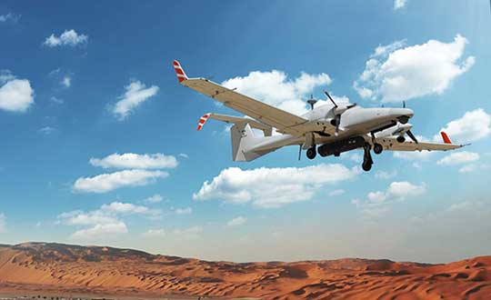
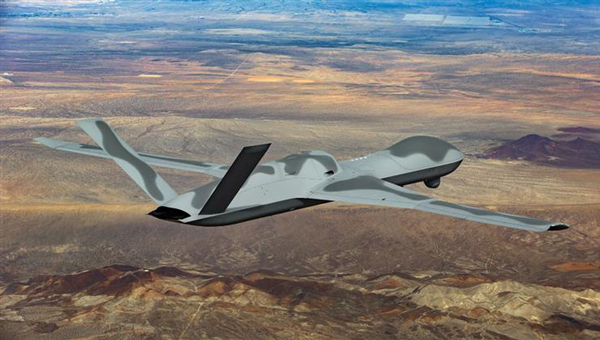
    One of the top dogs in the mil-spec UAV world, General Atomics Aeronautical Systems Inc. (GA-ASI) has developed and built several jet-powered demonstration UAVs known as the MQ-20 Avenger, which is currently being used to test out new U.S. Navy communications systems. Derived from the MQ-1 Predator and MQ-9 Reaper, the Avenger is equipped with a Pratt & Whitney turbofan jet engine, allowing it to reach speeds of around 400 Knots at an altitude of up to 50,000 ft.

    Predator C Avenger UAV. (Photo: GA-ASI)
    Predator C Avenger UAV. (Photo: GA-ASI)

    After extensive testing since its first flight in April 2009, a larger extended range (ER) version began test flights in 2016. The extended range version has longer wings and an increased fuel capacity with a range of 2,000 miles and an endurance of 20 hours. Avenger has several stealth features, including an S-shaped engine exhaust and an internal weapons bay for precision weapons and sensor packages, similar to the F-22 Raptor and F-35 Lightning front-line fighters. Another recent project saw F-35 technologies passed onto the same jet-powered UAV platform.

    The recent Navy communications trials were used to prove the new space-based comms capability and to remotely adjust Avenger’s autonomous internal navigation system while in flight. The aircraft has been designed for long-range, high altitude, speedy, autonomous penetration of enemy areas and this latest capability allows operations where the run-in-to-target phase can be redirected in the very last minutes of an attack. Enemy radar tracking and defenses might, therefore, be misaligned at a crucial phase of an incoming drone alarm without sufficient time to re-align and protect the actual target.

    Space-based communications, in this case, used signals via the Proliferated low-Earth orbit (LEO) system of satellites, which is reportedly a mil-spec LEO constellation of communications. satellites — somewhat related to the orbits of the Space-X commercial Starlink LEO internet satellite system.

    While we are in the military domain, a recently displayed Chinese development is being claimed to be a jet-powered ‘mothership’ UAV. The concept is that the carrier aircraft travels longer distances and releases a swarm of short-range drones when within range of their target(s) — a possible mock-up of such a vehicle was shown before a recent Chinese airshow.

    Jiu Tian mothership UAV mock-up. (Photo: Chinese internet)
    Jiu Tian mothership UAV mock-up. (Photo: Chinese internet)

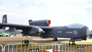
    The center section of the UAV appears to be detachable or has large opening doors – the Chinese and English inscriptions on it imply that it is a module for carrying drones. There have been other reports that Chinese military thinking includes the deployment of large swarms of drones to attack multiple targets simultaneously. However, The Jiu Tian UAV does not come with a stealthy design.

    In light of the recent competition between the U.S. and China, an article about the new U.S. Air Force B-21 stealth bomber has been published. The article suggests that, given the F-35 stealth fighter-bomber’s exceptional stealth capabilities and its ability to carry and release multiple weapons from an internal bay, the B-21 may already face obsolescence.

    So then, why not re-purpose the B-21 to be a drone-carrying mothership that could, while undetected, penetrate enemy defenses to release swarms of U.S. attack drones?

    B-21 next generation Stealth bomber. (Photo: U.S. Air Force)
    B-21 next generation Stealth bomber. (Photo: U.S. Air Force)

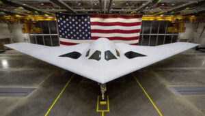
    Currently, a part of the U.S. three-pronged nuclear delivery deterrents alongside submarines and ballistic missiles, the Air Force believes that the role of the existing B-2 Spirit bomber is not obsolete, and the B-21 should become operational as planned in the 2030s with its new stealth and suite of high-end technology sensors and control systems.

    The concept of a Chinese “mothership” is designed to transport drone swarms close to targets before launching them. Additionally, there may be a stealthy response from the US, utilizing low-Earth orbit (LEO) satellites for space-based communications to adjust the routing of autonomous drones. This approach raises the question of whether it could be used to deceive drone defenses during the terminal phase of an attack. These solutions are complex but could significantly enhance the effectiveness of future military drone operations.

  • Honeywell launches ultra-rugged IMUs for commercial, defense use

    Honeywell launches ultra-rugged IMUs for commercial, defense use

    As illustrated here, the new HG1126 IMU is about the size of a water-bottle cap. (Photo: Honeywell)
    As illustrated here, the new HG1125 IMU is about the size of a water-bottle cap. (Photo: Honeywell)

    Honeywell has launched a new series of miniature inertial measurement units (IMUs) ruggedized to offer high accuracy along with the durability to survive high-shock environments.

    Roughly the size of a water-bottle cap, the new HG1125 and HG1126 IMUs are low cost and serve both commercial and military applications.

    The new family of IMUs can survive shocks up to 40,000 G-force, making it one of Honeywell’s toughest IMU products to date. The HG1125 and HG1126 can be used for a variety of defense and commercial applications such as tactical military needs, drilling, unmanned aerial vehicles or navigation systems for general aviation aircraft.

    “Low-cost, ultra-rugged IMUs are in high demand across a variety of market segments where customers need high-performance navigation, but they’re limited by size or cost constraints,” said Matt Picchetti, vice president and general manager, Navigation & Sensors, Honeywell Aerospace. “Our new HG1125 and HG1126 products meet all of these requirements, making them an ideal solution for customers operating in a wide variety of high-shock environments, including everything from military tactical operations to industrial applications such as drilling.”

    An IMU uses gyroscopes, accelerometers and electronics to give precise rotation and acceleration data. This enables a vehicle system to calculate where it is, in what direction it is going, and at what speed, even when GPS signals are not available.

    The HG1125 and HG1126 use sensors based on micro-electromechanical systems (MEMS) technology to precisely measure motion. They are the newest IMUs from Honeywell’s tactical IMU production facility, which delivers nearly 100,000 IMUs each year to customers across a wide range of segments.

    The first deliveries of these new products are set to begin in June.

    Honeywell’s lineage in navigation dates to the 1920s, and it has long been a pioneer in MEMS-based IMUs. Honeywell has developed and manufactured high-performance navigation solutions found on many aircraft and other vehicles worldwide.

  • Altitude Angel launches drone management solution for airports

    Altitude Angel launches drone management solution for airports

    Image: Altitude Angel
    Image: Altitude Angel

    Altitude Angel, a unified traffic management (UTM) technology provider, is bringing to market airspace management solution GuardianUTM Enterprise.

    GuardianUTM Enterprise provides a view of the airspace in the vicinity of airports and enables airport to start designing and providing UTM services for drone companies and drone operators, using Altitude Angel’s proven digital authorization and flight-management technology.

    GuardianUTM Enterprise will initially be deployed to support regional and local airports and airfields.

    Europe’s EASA U-Space regulations are expected to become law on Jan. 1, 2023. GuardianUTM Enterprise is designed to enable airspace authorities to digitize approvals for drone operations using services integrated with Common Information Service (CIS) and U-Space Service Providers (USSP) architectures.

    Using GuardianUTM Enterprise, airports can set access policies and create automation workflows accessible via Altitude Angel’s UTM ecosystem. This ecosystem is used by hundreds of thousands of drone pilots, manufacturers and software companies to guarantee the airport the best available view of the sky and nearby drone operations, ensuring a growing sector of the aviation market is able to access the new airport UTM Service.

    For larger airports with counter-UAS solutions, data from on-site surveillance systems can be optionally integrated to give airport security staff greater situation intelligence which is a critical step in encouraging greater drone use.

    The solution can be rapidly deployed and configured for airports of any size; providing a flexible platform for enabling drones to be safely integrated in the airspace around these facilities: a crucial step in unlocking a wide variety of unique use-cases for drones.

    GuardianUTM Enterprise provides digitalization of pre-flight and take-off approvals to drone operators within airspace. It offers high levels of automation, including customized automated access policies and approval workflows of unmanned operations.

  • FLIR Systems acquires Altavian for defense sUAS

    FLIR Systems acquires Altavian for defense sUAS

    Photo: FLIR Systems
    Photo: FLIR Systems

    FLIR Systems Inc. has acquired Altavian Inc., a privately held manufacturer of small unmanned aerial systems (sUAS) for defense and public-safety customers.

    Altavian’s airframes integrate multiple sensors, including FLIR thermal technology, to provide users with decision support and intelligence, surveillance and reconnaissance (ISR) capability.

    Based in Gainesville, Florida and founded in 2011, Altavian designs and manufacturers Group 1 UAS solutions for long or short range operations. With both quadcopter and fixed-wing UAS designs, Altavian’s expertise includes aeronautics, avionics, and software, and its solutions are engineered around an open system architecture aligned to the needs of government and defense customers.

    Altavian is one of five drone manufacturers approved by the U.S. Department of Defense under the Blue sUAS program to sell to the U.S. military and federal agencies.

    “Altavian’s proven engineering expertise and assets will allow us to offer customers the most comprehensive solution portfolio of any American sUAS provider,” said Roger Wells, general manager of the Unmanned Systems and Integrated Solutions business of FLIR Systems’ Defense Technologies Segment, under which Altavian will be integrated. “With the addition of both a low-cost, rapidly deployable quadcopter and a longer range fixed-wing UAS, FLIR is strengthening its already impressive drone lineup, including our Black Hornet and SkyRaider platforms used extensively by militaries around the globe. We’re excited about the multiple new franchise opportunities FLIR will be able to pursue for defense, public safety, and industrial markets worldwide.”

    For more information about FLIR Systems’ existing sUAS solutions, visit flir.com/defense-uas.

  • New UAS manufacturer specializes in defense drones

    New UAS manufacturer specializes in defense drones

    CP Aeronautics offers American-built combat-proven unmanned aerial systems for defense, homeland security and civil applications

    CP Technologies has launched a new division, CP Aeronautics, to provide integrated turn-key solutions based on unmanned aerial systems (UAS) platforms, payloads, data links, ground control stations (GCS) and communications for defense and civil applications.

    Designed as leading-edge UAS-based solutions, CP Aeronautics’ systems offer operationally proven solutions for intelligence, surveillance and reconnaissance (ISR) systems requirements. CP Aeronautics’ broad product portfolio has demonstrated excellent performance and operability in demanding environments, the company stated in a press release. Backed by continuous research and development, these systems are built on three decades of technological and operational experience.

    “Through our in-house capability as a UAS manufacturer and integrator with specialist subsidiaries and technology partners, we offer a complete range of subsystems including air vehicles, inertial navigation and avionics, electro-optical payloads (EO), communications, propulsion systems, launch and retrieval systems, command and control units,” said Brad Pilsl, vice president of business development at CP Aeronautics. “We also offer high-end training solutions for our partners and customers.”

    CP Aeronautics will support government and commercial customers with the entire infrastructure necessary for development, production, integration, flight-testing, certification and operational support of UAS throughout their service.

    The combat-proven operational systems include:

    • Orbiter 2 Small-UAS (SUAS)
    • Orbiter 3 Small Tactical UAS (STUAS)
    • Orbiter 4 Small Tactical UAS (STUAS)
    • Aerostar Tactical UAS (TUAS)
    • Dominator XP (MALE UAS)
    • Pegasus 120 high-performance multi-mission vertical takeoff and landing (VTOL) UAS
    The Dominator XP UAS. (Photo: CP Aeronautics)
    The Dominator XP UAS. (Photo: CP Aeronautics)
  • Trimble’s compact GNSS board gives high-precision positioning to UAVs

    Trimble’s compact GNSS board gives high-precision positioning to UAVs

    The UAS1 GNSS receiver module has been designed for UAV/UAS applications requiring centimeter accuracy in a small package.(Photo: Trimble)
    The UAS1 GNSS receiver module has been designed for UAV/UAS applications requiring centimeter accuracy in a small package.  (Photo: Trimble)

    Trimble has introduced a compact, high-precision GNSS board specifically designed for unmanned aerial systems (UAS).

    The Trimble UAS1 has a simple connectivity and configuration to allow UAS system integrators to easily add satellite-based positioning — with the ability to upgrade its capabilities — using rugged connectors and Trimble’s easy-to-use software interface.

    The new UAS1 incorporates the latest Trimble Maxwell technology with advances in high-precision GNSS positioning. Its GNSS engine with 336 channels is capable of tracking L1/L2 frequencies from the GPS, GLONASS, Galileo and BeiDou constellations for robust centimeter-level, real-time kinematic (RTK) positioning.

    The compact board includes a broad range of receiver capabilities — from high-accuracy GPS-only to full GNSS features for positioning. Firmware options and features are password upgradeable, allowing functionality to be added as requirements change.

    The receiver also supports fault detection and exclusion (FDE) and receiver autonomous integrity monitoring (RAIM). System integrators also have the ability to detect interference with the RF Spectrum Monitoring and Analysis tool embedded in the receiver.

    “UAS manufacturers demand high performance, reliability and high-quality customized support for their positioning solutions,” said Thomas Utzmeier, general manager of Trimble’s Integrated Technologies Division. “The new UAS1 board delivers the latest GNSS technology in an easy-to-integrate form factor for UAV/UAS applications.”

    Designed for easy integration and rugged dependability, the Trimble UAS1 has a Remote Network Driver Interface Specification (RNDIS) that enables manufacturers to access the web UI with the USB connector. As with similar Trimble embedded boards and modules, easy-to-use software commands can simplify integration and reduce development times.

    Features also include integrated Trimble RTX technology, an industry-standard camera hot-shoe interface to geo-position photographs, and LED indicators for status checks. The Trimble UAS1 can also output to RINEX, a common postprocessing format.

    The Trimble UAS1 supports Trimble CenterPoint RTX GNSS corrections, which enable precise and robust positioning without the use of a base station via a subscription service. CenterPoint RTX allows users to achieve better than 2-centimeter horizontal and 5-centimeter vertical accuracy.

    Trimble’s UAS1 is suitable for UAS applications requiring centimeter accuracy in a small package. Manufactured and tested to Trimble’s highest quality standards, the compact design allows for easy setup, configuration and installation in a customers’
    system.

    Using a full metal shield (the form factor is 71 x 46 x 13 millimeters), the board’s design enables high-precision GNSS signal protection from electromagnetic interference (EMI) on the host UAS platform. In addition, the receiver is FCC- and CE-certified, which speeds compliance for the customer’s overall system and can reduce time to market.

  • ANSI establishes UAS standardization collaborative

    A May 19 meeting convened by the American National Standards Institute (ANSI) confirmed there is broad-based support among key stakeholders from the private and public sectors for ANSI to establish an Unmanned Aircraft Systems (UAS) Standardization Collaborative (UASSC).

    The UASSC will work to coordinate and accelerate the development of the standards and conformity assessment programs needed to facilitate the safe, mass integration of UAS (drones) into the national airspace system of the United States.

    Initial priority areas of focus are expected to include:

    • UAS airworthiness
    • command and control systems
    • remote identification
    • flight operations, including operations over people and beyond visual line of sight
    • licensing, training, qualification and certification
    • sense and avoid systems
    • safety and risk management

    An initial kick-off meeting is anticipated in the third quarter of 2017. To stay up to date regarding future developments, email Jim McCabe, ANSI senior director, standards facilitation, at [email protected].

    The collaborative will also focus on international coordination and adaptability, with the goal of fostering the growth of the UAS market. The work effort will entail the development of a standardization roadmap to identify existing standards and standards in development, define where gaps exist and recommend additional work that is needed, along with a timeline for its completion and organizations that can perform the work.

    ANSI Standardization Collaboratives are formed to support emerging technologies and national and global priorities by advancing cross-sector coordination in the development and compatibility of standards and conformance programs.

    Ultimately, the purpose of such initiatives is to describe the current standards landscape, articulate standardization needs, inform resource allocation for standards participation, and drive coordinated standards activity while minimizing duplication of effort.

    As a neutral facilitator, ANSI has a successful track record of having convened a number of such collaboratives in areas as diverse as homeland security, electric vehicles, energy efficiency in the built environment and, most recently, additive manufacturing.

    The May 19 meeting drew close to 70 participants representing more than 40 organizations from industry, trade associations, standards developing organizations (SDOs), federal agencies, academia and others. The public- and private-sector co-chairs for the meeting were Earl Lawrence, director of the UAS Integration Office, Federal Aviation Administration, and Brian Wynne, president and CEO of the Association for Unmanned Vehicle Systems International (AUVSI).

    ANSI has been in dialogue with numerous stakeholders over the past year on this topic, including via panel discussions during the 2016 ANSI Joint Member Forum and at the April 2017 ANSI Company Member Forum. A number of SDOs already are involved in UAS standardization, underscoring the need for coordination to achieve a coherent set of standards.

    “Given our history of bringing public- and private-sector stakeholders together to identify standardization needs to support new technologies, ANSI is well suited to facilitate the need for standards coordination in this exciting new technology area,” said ANSI president and CEO S. Joe Bhatia.

  • Septentrio expands in Europe by signing new partnership with Innovelec

    Septentrio expands in Europe by signing new partnership with Innovelec

    The AsteRx-m UAS by Septentrio.
    The AsteRx-m UAS by Septentrio.

    Septentrio, a designer and manufacturer of GNSS solutions, has selected Innovelec as an authorized partner for GNSS positioning solutions in the United Kingdom and Europe. The new partnership will enable Septentrio’s products such as AsteRx-m UAS to meet the needs of unmanned aerial systems (UAS) customers in the European market, the company said.

    Based in Hemel Hempstead in Hertfordshire, Innovelec will work directly with Septentrio to offer high-quality strategic services and technical expertise necessary to meet the current and future requirements of GNSS customers in the United Kingdom and UAS customers across Europe to develop new business opportunities in the market.

    Since last year, Septentrio has introduced a new set of products that achieve a new benchmark for accuracy and reliably in GNSS solutions. Innovelec will supply the AsteRx product line — renowned for providing consistent and robust centimeter-level positioning under challenging interference and multipath environments.

    The AsteRx-m UAS OEM is compact and lightweight module which offers the lowest power consumption on the market at 600 mW. Another product, the AsteRx4, is a robust dual-antenna receiver ready for rapid and straightforward integration into existing workflows or hardware.

    “Septentrio’s AsteRx product line offer unbeatable performance, accuracy and reliability in the most challenging conditions,” said Koen Gutscoven, director of Sales at Septentrio. “Innovelec complement Septentrio’s skills to aid further growth in the UK and European market.”

    “Septentrio presents an exciting opportunity for Innovelec to further develop its significant business within the GNSS market. Flexibility and support in conjunction with our partners have helped Innovelec to grow and it remains a benchmark of our operations,” said Martin Newman, sales director of Innovelec. “Septentrio bring a lot of expertise of the GNSS market to help us develop new sales opportunities and loyal clients for accurate and reliable positioning across the European market. “

  • New Esri Book Covers Aerial Imaging Basics for GIS

    EssentialEarth_medSatellites, aircraft and unmanned aerial systems (UAS) collect imagery that can be displayed and analyzed within a geographic information system (GIS) to extract important information.

    To familiarize GIS professionals and students with the advanced earth imaging technologies available today, Esri has published Essential Earth Imaging for GIS. The book is a field guide to Earth imaging, providing guidance to efficiently and effectively display, manipulate, enhance, and interpret features from an image. Essential Earth Imaging for GIS provides a basic education in remote-sensing technology, promoting the effective use of sophisticated multispectral and 3D imagery.

    Chapters introduce readers to remote-sensing methods and types of imagery as well as how to display and enhance multispectral images, process images in a GIS to improve quality, generate three-dimensional data, and visually interpret images in a GIS to extract information from them.

    The book provides hands-on experience working with imagery in Esri’s ArcGIS for Desktop and ArcGIS Online. Exercises include assigning colors in multiband images and extracting information from multispectral images by digitalizing features. Companion exercises and a free 180-day trial of ArcGIS are available by accessing the Esri Press Book Resources website.

    Essential Earth Imaging for GIS was written by Lawrence Fox III, emeritus professor of forest remote sensing and GIS at Humboldt State University in California. The book serves as a starting point for GIS professionals who want to learn the basics of imaging technology so they can incorporate it more effectively into their work, while students can use this book as a reference for introductory GIS courses that make use of image display and analysis.

    Essential Earth Imaging for GIS is available in print (ISBN: 9781589483453, 128 pages, US$59.99) or as an e-book (ISBN: 9781589484313, 128 pages, US$59.99). The book is available at online retailers worldwide, at esri.com/esripress, or by calling 1-800-447-9778. Outside the United States, visit esri.com/esripressorders for complete ordering options, or visit esri.com/distributors to contact your local Esri distributor. Interested retailers can contact Esri Press book distributor Ingram Publisher Services.

    Esri Press publishes books on GIS, cartography, and related topics. The complete selection of GIS titles from Esri Press can be found on the web at esri.com/esripress.

  • CHC Introduces UAV Ground-Control Specific GNSS System

    CHC Introduces UAV Ground-Control Specific GNSS System

    The UAV Ground Control (UAV GC) and post-processing kit for high-precision UAV systems by CHC Navigation.
    The UAV Ground Control (UAV GC) and post-processing kit for high-precision UAV systems by CHC Navigation.

    CHC Navigation has launched a new UAV Ground Control (UAV GC) and post-processing kit for high-precision UAV systems. This kit is designed to provide an easy-to-operate complete system, and be cost-effective for producing centimeter-level control for UAV projects.

    The standard kit includes five GNSS receivers with expansion of additional receivers in pairs. The core of the system is the X900+OPUS, a dual-frequency triple-constellation receiver capable of cm positioning of the project at 200 km in absolute geodetic space. The secondary X20+ receivers serve as ground-control points for orthorectification, project verification, and other high-accuracy positional tasks.

    Photo: CHC Navigation“Low cost and easy to use, the CHC UAV GC system is a necessity for any UAV manufacturer or operator who is interested is promoting/proving the high accuracy of their deliverables,” said George Zhao, CEO of CHC Navigation. “The UAV Package offers unrivaled performance at an unheard of low price, and fills the last remaining gap for a complete whole product solution in the UAV market.”

    The UAV GC kit is now available through the existing CHC distribution channel worldwide.

  • Exelis Disruptor SRx Electronic Warfare Technology Explained

    Marty Apa, chief engineer for Exelis’ Integrated Electronic Warfare Systems, shows GPS World the Disruptor SRx at Unmanned Systems 2015, held May 4-7 in Atlanta. The Disruptor SRx electronic warfare (EW) technology is small enough to fit into UAS (unmanned aerial systems). It also has the ability to switch between multiple functions in real time.

  • NavCom Technology Offers Navigation and Positioning Capabilities for UAS

    NavCom Technology’s Jim Williams explains the precise positioning and navigation solutions offered by the company for UAS (unmanned aerial systems) at Unmanned Systems 2015, held May 4-7 in Atlanta. It offers GNSS aerial antennas, RTK positioning and its StarFire global satellite-based augmentation system (GSBAS).