Unifly, in cooperation with Nexova, have successfully completed the SecureUTM 2 Phase I under the European Space Agency’s (ESA) NAVISP program, with emphasis on mitigating GNSS jamming and spoofing.
The project establishes a certification-aligned, risk-driven cybersecurity foundation for secure, resilient and scalable unmanned traffic management (UTM) and U-space services across Europe.
As drone operations grow in complexity and cross-border interoperability, cybersecurity is becoming essential for operational continuity and public trust. SecureUTM 2 embeds cybersecurity engineering into the core architecture of UTM systems, aligning with European U-space regulations, Common Criteria methodology and ENISA risk frameworks. Security is treated as a foundational design principle rather than a late-stage compliance requirement.
Building on SecureUTM 1, SecureUTM 2 Phase I significantly expanded the cybersecurity baseline for UTM systems. Key outcomes include:
Refinement of a harmonized Protection Profile (PP) for UTM
Development of an updated Security Target (ST) for the Unifly platform
Structured risk assessment and certification-aligned gap analysis
Definition of a secure architectural baseline addressing real-world U-space complexity
Setup of a PoC Testbed
Risk-based engineering roadmap
A control-by-control gap assessment translated cybersecurity requirements into a prioritised implementation roadmap. Focus areas include:
PNT source authentication and plausibility checks
Enhanced session integrity and transport protection
Denial-of-Service resilience
Device-level authentication and auditing
Secure storage and encryption
This structured approach supports operational deployment and future EU cybersecurity certification readiness.
Validated mitigations for GNSS and PNT threats
SecureUTM 2 phase I placed strong emphasis on GNSS jamming and spoofing risks increasingly observed in drone operations. Practical, layered mitigations were validated through a dedicated U-space proof-of-concept testbed with Hardware-in-the-Loop UAV simulations.
Validated measures include:
On-board GNSS jamming detection
Fleet-level interference inference
Trajectory plausibility and conformance monitoring
OSNMA-based message verification
Structured anomaly logging and alerting
The testbed enables repeatable attack simulation, KPI-based evaluation and regulator-ready evidence generation.
Foundation for Phase II and European deployment
Phase I also delivered a structured U-space testbed blueprint, verification methodologies and digital twin foundations to support continued validation, operator training and continuous cybersecurity testing.
SecureUTM 2 directly supports Belgium’s U-space deployment strategy and strengthens its position in secure drone integration.
Phase II will focus on implementing prioritised controls, expanding validation capabilities and further aligning with EU certification frameworks.
The Federal Aviation Administration’s new Beyond Visual Line of Sight (BVLOS) framework, incorporating Part 108 and Part 146, establishes a regulatory pathway for safe and scalable drone operations. This framework is expected to accelerate the integration of both drone deliveries and air taxis into everyday transportation networks. What was once a conceptual vision has now become an actionable roadmap, supported by technology that enables safe and collaborative use of lower airspace.
Airwayz offers an artificial intelligence–driven unmanned traffic management (UTM) and U-Space Service Provider (USSP) system designed to coordinate multiple drone operators sharing the same airspace. Unlike static management systems, Airwayz’ platform provides fully dynamic airspace allocation and routing, allowing multiple fleets to operate simultaneously without interference. The system is capable of validating and approving flights, as well as suggesting updated routes, within approximately five seconds. This enables continuous, real-time decision-making in response to changing conditions.
Autonomous Decision-Making and Human Oversight
The Airwayz UTM constantly monitors the airspace for both manned and unmanned aircraft, dynamically adjusting flights to reduce the risk of collision. Using autonomous rerouting capabilities, the system can alter a drone’s course mid-flight if safety conditions change. Although much of the operation can occur without manual intervention, human operators retain the authority to override automated decisions, ensuring an added layer of accountability. This approach shortens approval times, avoids dedicating airspace to only one operator, and streamlines operations for complex missions.
Central to the Airwayz UTM/USSP is a focus on safety. The system evaluates environmental and operational risks by monitoring nearby aerial activity, weather patterns, and other critical factors. When potential hazards are detected, it recommends the most effective course of action to avoid incidents. These recommendations can involve route changes while the drone is already in flight, ensuring that missions can be completed without compromising safety.
By enabling fully dynamic and responsive airspace management, Airwayz UTM allows drones to travel between any two points at any time, provided flights are reported to and coordinated through the system. Continuous monitoring during both pre-flight and in-flight phases ensures that adjustments can be made immediately when risks emerge. This flexibility increases the commercial capacity of the airspace, while maintaining safety as the primary priority.
Temporary U-Space for Specific Operations
For short-term events or limited-duration needs, Airwayz employs a “temporary U-Space” approach. These temporary zones can be quickly established to manage high-priority or ad-hoc operations and are dismantled once no longer necessary. AI algorithms analyze and predict flight paths, assess the reliability of those predictions, and adjust the boundaries of the temporary U-Space according to risk levels. In low-risk scenarios, boundaries can be minimized to allow more concurrent aircraft, while higher-risk situations trigger expanded safety zones.
The flight test is the third of several to simulate a variety of real-world scenarios that demonstrate how UTM and ATM intersect with multiple aircraft types.
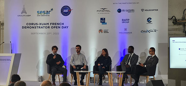
M3 Systems, Pipistrel and Volocopter have completed their first joint flight test campaign in France at Pontoise airfield.
The week-long flight tests simulated three different avoidance maneuvers in real-world situations where unforeseen circumstances occur, such as a complete airport or vertiport closure, an unavailable final approach and takeoff area, and traffic deconfliction.
M3 Systems was created from engineering activities in GNSS and consulting activities in air traffic management (ATM), including for uncrewed aircraft. M3 played a role in Galileo signal definition, among other projects for Europe’s various space agencies. Pipstrel is a light aircraft manufacturer specializing in electric propulsion, and Volocopter specializes in urban air mobility (UAM) systems.
The joint campaign among the three companies — with French partners Groupe ADP and its subsidiary Hologarde — aimed to achieve smooth interaction within and between the new lower airspace’s unmanned traffic management (UTM) and standard civil aviation ATM systems.
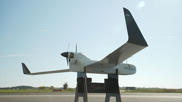
The Boreal system is a fixed-wing UAV with high-endurance and heavy payload capacity. (Photo: M3 Systems)
The aviation industry is experiencing an innovation upsurge driven by technology and societal pressure for new forms of aviation focused on sustainable, digital and autonomous air mobility. The resulting solutions will generate a significant increase in traffic density in the lower airspace.
Because existing ATM systems are not designed to handle such volumes or digitalization, coordinating existing and new traffic management systems for brand-new aircraft integration will ensure efficient large-scale operations. This includes commercial, general and drone aircraft for cargo and passenger flights, both crewed and uncrewed.
The CORUS-XUAM project, funded by the European Union’s initiative Single European Sky ATM Research (SESAR) Joint Undertaking, focuses on solving the challenge of conventional and new traffic management system integration and consists of 19 partners and 11 third parties. M3 Systems, Pipistrel and Volocopter all completed individual flight-test campaigns before this event to bring their aircraft in line with the U-space services.
A week of flight tests ended with an Open Day air show and presentations. (Photo: M3 Mobility)
The CORUS-XUAM flight test conducted at Pontoise airfield near Paris is the third of several flight tests to simulate a variety of real-world scenarios that demonstrate how UTM and ATM intersect with multiple aircraft types.
Moreover, the CORUS-XUAM project will continue to proactively test and create a safe and controlled lower airspace under the European Union’s ambitious Single European Sky (SES) initiative throughout 2022.
The successful flight tests at Pontoise airfield were conducted with M3 System’s Boreal remotely piloted aircraft system, Pipistrel’s crewed Velis Electro, the only type-certified electric aircraft in commercial service in the world, and Volocopter’s fullscale, remotely piloted 2X prototype. Pipistrel uses the conventional ATM tower and system while Volocopter and M3 Systems use the UTM system. The following three flight scenarios were tested:
The unexpected occupancy of a final-approach-and-takeoff plan and aircraft diversion because of priority landing of another aircraft (Pipistrel and Volocopter aircraft).
The diversion of a flight path because of the closure of an airport or vertiport (M3 Systems).
The diversion of a flight path with two aircraft flying the same path (M3 Systems and Volocopter aircraft).
“These successful tests confirm that our Boreal UAS will be an enabler for future XUAM operations in situations where aircraft need to safely divert paths to another vertiport due to an unforeseen closure or another aircraft in the air,” explained Marc Pollina, M3 Systems CEO. “By providing rerouting demonstrations and tactical communications with U-Space service providers, M3 Systems can support future coordination between AAM and airport operators.”
Pipistrel is “As the manufacturer of the only type-certified electric aircraft in commercial service in the world, proud to take part in technical projects that shape the vision of air mobility and make progress in a meaningful way,” said Gabriel Massey, Pipistrel president. “The CORUS project and Paris demonstrations clearly show how UAM vehicles will be able to fly safely in regular airspace post-2030 and will help to unlock new lower-noise and lower-emission air passenger and air cargo services.”
In 2019, Volocopter tested its 2X ATM integration at Helsinki airport and was actively involved in the development of the European U-Space Concept of Operations, according to Oliver Reinhardt, Volocopter’s chief risk and certification officer. “Building an efficient ecosystem around UAM is Volocopter’s mission, and connecting ATM/UTM integration with our digital platform, VoloIQ, is poised to be an integral part of bringing UAM to megacities worldwide,” Reinhardt said. “I am looking forward to the next CORUS-XUAM test flights later this year in Germany and what we can achieve there.”
The project has received funding from the SESAR Joint Undertaking under the European Union’s Horizon 2020 research and innovation program under grant agreement No. 101017682.
Altitude Angel, a London, U.K.-based unmanned traffic management (UTM) technology provider, is releasing an open-sourced project, Scout.
Scout’s hardware and firmware enable drone manufacturers, software developers and commercial drone pilots to quickly connect to its global UTM.
Primarily intended for use in commercial and industrial drone applications, Scout provides the capability to securely obtain and broadcast a form of network remote ID, widely seen as a necessary step for enabling routine drone use and flights beyond visual line of sight.
Because it is open source, both the hardware and the firmware can be enhanced and incorporated into a virtually limitless set of scenarios, according to Altitude Angel.
Altitude Angel also has made available a surveillance API that allows integrators to both share and receive flight data from a variety of sensors and devices in near real time, providing a comprehensive real-time picture of the airspace.
While many remote ID systems are broadcast only, Scout offers two-way communication and is fully open-sourced. The ability to talk back to the drone enables the Altitude Angel UTM service to help the drone avoid collisions with other aerial vehicles, or restricted airspace.
From launch, Scout will use identifiers obtained freely from Altitude Angel’s GuardianUTM platform. It will work in combination with a pre-flight (flight-plan sharing) service and is supported through integration with Altitude Angel’s Tactical Conflict Resolution Service.
Scout will enable the drone to report its real-time location using GPS-type sensors and relay this data via a secure, encrypted mobile communications link across 3G, 4G and 5G networks to Altitude Angel. It is powered by an internal rechargeable (via micro USB) lithium battery.
Altitude Angel has also provided reference design plans for the case that can be 3D printed. Scout has been designed to satisfy emerging network remote ID standards, such as ASTM.
Because the firmware is open source, the telemetry can be sent to other systems as required by the implementor.
A two-wire I2C upgrade to the circuit schematics, plus version 2 of the firmware (both scheduled for June), will subsequently enable the full two-way communication between the Scout device and the drone’s onboard systems, allowing the drone to respond directly to information received from the UTM.
In the interim, early adopters will have the opportunity to begin to integrate with Altitude Angel’s UTM services, test the hardware and test communication. Position data Altitude Angel receives from Scout is then automatically used by its Flight Information Management System (FIMS) to help provide traffic deconfliction.
Plans, firmware and schematics can be accessed via the Altitude Angel GitHub repositories.
Analytics provider Teoco has been selected by Telstra — a mobile network in Australia — to assist with the development of its UAV strategy.
Telstra will use Teoco’s AirborneRF solution to assess the readiness of its radio access network for future UAV applications, including communications, navigation, surveillance, safety and identity.
Teoco is a provider of analytics, assurance and optimization solutions to more than 300 communication service providers (CSPs) and OEMs worldwide.
Already deployed by several tier-one operators globally, AirborneRF ensures effective, mission-critical connectivity to enable effective traffic management and control for UAVs in the lower airspace. Telstra will use the solution to develop a platform for enabling a multitude of mission-critical services, vital in supporting successful UAV operations.
The platform provides a link between cellular networks and aviation systems, such as air traffic management (ATM), unmanned traffic management (UTM) and flight information management systems (FIMS).
TEOCO’s AirborneRF solution will play an important role in assisting Telstra enable a safe, equitable, secure and reliable urban air space platform. This has become all the more important to Telstra following Uber’s decision in 2019 to use Melbourne as one of three pilot cities to test out its “flying taxis” — the pilot is expected to begin this year, with commercial operations planned for 2023.
Telecommunications companies can provide needed UAV services via their mobile networks. For the internet of things (IOT), they can provide drone registration, activation and identification. For 5G, they can provide super low-latency remote command and control and high-resolution video carriage.
“We have been running a number of drone-related technology assessments with various industry customers, within law enforcement, humanitarian aid, post disaster, first responders and city councils, over the past 12 months,” said Thomas Neubauer, vice president of Business Development, TEOCO.
“Commercial UAVs present a huge opportunity for [[telecommunications]] operators, but only if supporting mobile networks deliver the required connectivity to keep them airborne,” Neubauer said. “Mobile networks were not designed to meet the needs of the aviation industry, so tight focus is needed to guarantee the quality of service needed to safeguard the additional revenue that connected skies promise. Our Airborne RF solution offers this guarantee to a growing number of major operators around the world.”
UAVs are finding places in the lives of more people than ever — farmers employing crop-spraying drones to counter a locust infestation in Pakistan, finding the way towards useful inspection tasks at an operating airport in the U.K., large airborne vehicles providing joy-rides around the U.S., and unfortunately showing up where they are not wanted so security staff have to use protection systems to deal with them.
Crop Spraying
New unmanned air vehicle (UAV) applications keep appearing. Once they do, they start to spread locally and even around the world. Crop management using UAVs has significantly progressed.
The U.S. has used crop spraying to improve crop yield for many years, defending against insect infestation and plant diseases. GNSS guidance systems for crop-spraying aircraft was an early satnav equipment application that eventually became a standard for any fliers contacted by farmers to apply pesticides to protect their crops. Then companies began offering turn-key spraying, which was highly efficient and effective.
UAVs are now entering this segment — they are capable of carrying higher capacity tanks, and autonomous/semi-autonomous navigation enables spraying with minimum supervision. This option is becoming more readily available to the farmer and costs less than using manned aircraft.
Both Japan and China have used UAVs extensively for crop spraying; other countries turning to the solution are Africa, the U.S. and India. In China, more than a hundred different types of UAV are in use in agricultural applications.
Farms around the mega-city of Karachi, Pakistan, have been infested by locusts, but the local government is short of the helicopters and ground applicators normally used for spraying pesticides. A recent graduate returning from his doctoral course in China brought with him knowledge of unmanned vehicle use in agriculture, and is urging rapid local adoption of UAV technologies to combat the locust infestation.
Pakistani agriculture expert Shahzad Nahiyoon claims that UAVs are better suited to crop protection for small farms within difficult contours of the surrounding region. They are less expensive to operate than manned fixed-wing and rotary aircraft, may be operated locally from outside spray contamination zones, and can spray in confined areas. Equipped with a 20-liter tank, spraying one or two 20-meter-wide swaths, 6 to 10 hectares per hour can be treated.
Drones at the airport
Growing a little weary of drone incidents around airports, I was pleased to see a report I had overlooked from a year ago which indicated that trials at Manchester airport in UK had demonstrated airport and drone compatibility. This basically happened because an Air Traffic Control (ATC) system for unmanned aircraft or Unmanned Traffic Management (UTM) was shown to keep drones flying around the airport under full control while integrated with regular airport and drone operations.
The trial — referred to as Operation Zenith — sponsored by the National Air Traffic Systems (NATS), made us of the GuardianUTM airspace management system, supplied by Altitude Angel, as the control system for eight trial drone missions at the airport. The drone UTM system was connected to the real-time Air Traffic Management (ATM) system which manages ground and air traffic at the airport, to ensure the control and safe separation of drones and aircraft. The UTM system also provided controllers with a real-time view of all operating drones.
The trial demonstrated the efficient regulation of drone traffic within and around the extremely sensitive airport region. Everyone engaged in the trial made use of real-time electronic map displays driven by the UTM system, showing everything flying in and around the airport; aircraft and drones. Drone pilots used this information to ensure their operations remained safe while operating so close to commercial aircraft in the air and on the ground.
NATS has now formed a strategic partnership with Altitude Angel to deliver this integrated UTM system at airports in the United Kingdom. The UTM system has successfully completed initial pilot trial and evaluation and now NATS intends to further demonstrate UAV management control at six U.K. airports later this year.
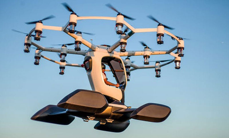
Thousands sign for ride with Lift Aircraft
Hexa in flight (Photo: Lift)
Lift Aircraft unveiled its 18-rotor Hexa unmanned/manned aircraft more than a year ago — what’s new now is that 13,000 people have signed up to take one for a ride.
The large drone weighs in at 432 pounds and can fly for 10-15 minutes with a single passenger.
The Hexa is controlled by a single joystick, and an onboard iPad provides route guidance and manages take-off and landing. Classed as a powered ultralight air vehicle, it can be flown without a pilot’s license, so Lift announced that it will offer Hexa flights to anyone wanting to fly (in 25 selected U.S. cities) provided they physically fit into it and weigh less than 250 pounds.
Lift intends to map each recreational flight area in 3D, and plug this map into the vehicle control system. The 13,000 people who signed up can expect to pay $125-250 for each joy ride. Lift has yet to announce the first location where the fun rides will take place.
Counter-UAS system downs drones in Philippines
The Southeast Asian Games were recently held in the Philippines with thousands of participants from eleven countries of Southeast Asia — the event was spread across 23 cities around the country. However, a number of uninvited drones showed up during the opening ceremonies on November 30th to take a look, but fortunately all were quickly dispatched.
The DroneShield counter-UAS system had been deployed in advance for protection of the event, and the local security forces used the system to detect and disable the invaders. According to the company, security personnel found the drones using body worn RF detection devices, and the Dronegun was then used to disable them.
Jamming the control link and GNSS L1 and L2 frequencies, UAVs are generally stopped in mid-flight when illuminated by the rifle-like device. DroneNode jammer in a suitcase was also used to provide blanket protection over a 1km circular area when the alarm was raised.
In all, seven unauthorized drones were disabled, some of which were apparently flying near the intended flight path of the helicopter bringing President Rodrigo Duterte to the opening ceremony.
Summary
It might seem a little ridiculous that we’ve had to come up with systems to counter uninvited or malicious drones (C-UAS). Making provisions for protection is probably something most sensitive facilities will have to do. Its possible that governments may already be investing in such technology to protect many facilities. More drones available for useful, productive and even recreational applications means some can end up in the wrong hands.
Nevertheless, good stuff comes out of drone applications, and the benefits seem to by far outweigh the need to protect ourselves against bad actors.
New solution integrates the real-time Kongsberg IRIS UAS airspace management picture into the AiRXOS’ Air Mobility Platform to provide integrated unmanned traffic management services around critical infrastructure
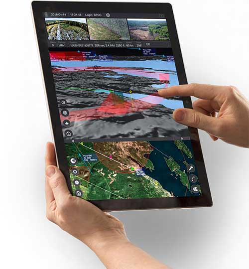
AiRXOS, part of GE Aviation, has fully integrated the real-time airspace picture from the Kongsberg Geospatial IRIS airspace management application into its own Air Mobility Platform for unmanned traffic management.
IRIS UAS is a spatial awareness system that allows UAS pilots to operate safely beyond visual line of sight (BVLOS). The system is shown here running on a Windows Surface Pro tablet. (Photo: Kongsberg Geospatial)
IRIS UAS fuses multiple disparate, real-time sensor feeds to create a highly accurate airspace picture around critical infrastructure locations such as airports.
This provides real-time calculation of aircraft separation, airspace monitoring alerts and communications line-of-sight prediction to enable detect and avoid for safe beyond visual line of sight (BVLOS) operations.
The real-time local airspace picture is then integrated into the cloud-based AiRXOS’ Air Mobility Platform, a dynamic, cloud-based foundation, purpose-built for advanced operations and the evolving future of transportation.
The Air Mobility Platform manages the volume, density, and variety of unmanned traffic management (UTM) data, and provides enterprises with a single platform to connect and manage operations, applications and devices.
Through this collaboration, the companies will provide UTM customers with a fully integrated view of airspace for real-time airspace insights, and greater scalability and repeatability of advanced operations.
“Situational awareness of the airspace across applications, unmanned aerial system (UAS) advanced operations, conformance monitoring, compliance, and pilots is critical to a UTM environment — allowing enterprises to be more responsive and efficient,” said Ken Stewart, CEO, AiRXOS. “Our partnership combines Kongsberg Geospatial’s expertise in airspace management with AiRXOS’ dynamic platform, applications, and services, providing customers with the opportunity to truly scale critical infrastructure advanced UAS operations like BVLOS and multi-vehicle, helping to lower risk and increase savings.”
“We’re very pleased to be working with an unmanned traffic management innovator like AiRXOS,” said Ranald McGillis, president of Kongsberg Geospatial. “Their ability to create a comprehensive surveillance view of operations and then to scale it for a nationwide use provides an excellent and very unique use case for our technology.”
Safely integrating autonomous drones into global airspace is the goal of Altitude Angel.
The company has completed its involvement in the Gulf of Finland (GOF) U-Space project, declaring the trials to have been a “huge success” and an “amazing showcase” of its unmanned traffic management (UTM) technologies.
The GOF U-space demonstrations are funded by the SESAR Joint Undertaking for European sky air traffic management research.
In July and August, advanced drone operational demonstrations took place across Estonia and Finland, showcasing use cases that involved both manned and unmanned aircraft in shared airspace. The demonstrations relied on systems such as Altitude Angel’s GuardianUTM O/S to remain safe.
GuardianUTM, the company’s core system, is already helping drones operate in controlled airspace. It powers the UK’s national UTM system, operated by NATS, the UK’s main air navigation service provider.
Altitude Angel was a key UTM partner for the trials, providing services that included integration to the FIMS (flight information management system) for the transport of flight plans, telemetry/position reports, AIM (geofencing/volume reservations), as well as alerts and registration data to-and-from the drone operators and manned aviation which were involved in the trials.
Altitude Angel was able to demonstrate its UTM platform across a number of scenarios that varied in scope and range, and included:
urban drone fleet operations with police intervention,
long-distance multisensory inspection flights over forests,
urban drone operations in controlled airspace,
powerline inspection in rural areas, maritime search and rescue, and
international parcel delivery.
The demonstration series concluded with an urban Volocopter air taxi flight around Vantaa International Airport, Helsinki.
“We’ve been working with the SESAR team for over a year on this project. It’s been a great few months in Finland and Estonia supporting the live demonstrations which have been huge success and an amazing showcase of our world-leading UTM technologies,” said Simon Wynn-Mackenzie, Altitude Angel’s head of products.
“Not only did the scenarios give us another opportunity to demonstrate our production UTM platform in another real-life environment, they went a long way to showing the public how drones can be used in a positive and socially beneficial way on a daily basis,” Wynn-Mackenzie said.
“Our only disappointment was that we were not able to demonstrate our world-first Conflict Resolution Service which we unveiled in July, as the trial scenarios had already been agreed. However, we’ll be looking to showcase our constantly evolving platform and several new services very soon,” he said.
Other UTM demonstrations. In November 2018, Altitude Angel led the team behind Operation Zenith, which gave a view of the future of air traffic management and drone integration into busy, complex airspace, demonstrating how by using the right technology, it’s possible to safely integrate unmanned traffic into controlled airspace and open the skies to commercial airspace worldwide.
The U-space initiative. The GOF U-space project, with a broad consortium of 19 members, demonstrates Europe is on course with its implementation of U-space, an initiative that aims to ensure safe and secure drone traffic management, taking into account the rapid growth in the use of drones.
The GOF concept enables shared situational awareness for all aviation stakeholders. The success of the project is based on deep air traffic management experience of all consortium members, including three world-leading UTM technology vendors and two air navigation services providers, developing interoperability and data-sharing solutions that are aligned with SESAR’s overall U-space architecture.
The U-Space project has received funding from the SESAR Joint Undertaking under the European Union’s Connection Europe Facility (CEF) programme under grant agreement SJU/LC/343-CTR.
The Nevada Institute for Autonomous Systems (NIAS) and its NASA Unmanned Traffic Management (UTM) partners flew multiple unmanned aerial systems over a week-long testing period at the Nevada UAS Test Site at the Reno-Stead Airport.
NASA UTM Testing. Credit: NIAS. (PRNewsfoto/Nevada Institute for Autonomous)
This third phase of NASA’s UAS testing (TCL 3) again focused on airspace management technologies that will enable the safe integration of UAS into the national airspace.
NASA provided a Flight Information Management System (FIMS) research platform that will serve as a future prototype system for the U.S. Federal Aviation Administration (FAA) to use to coordinate with unmanned service suppliers operating throughout the nation.
Research areas of emphasis during the testing included UAS ground-control interfacing to locally manage operations, communication, navigation, surveillance, human factors, data exchange, network solutions and beyond-visual-line-of-sight (BVLOS) architecture.
On media day, a team from the Reno Fire Department simulated an incident with a victim experiencing severe blood loss and who needed an immediate transfusion. A multi-rotor UAS from Drone America was equipped with a container that held an actual packet of blood to be transported via drone in Nevada.
High winds and frigid temperatures tested both the drone and those on the ground, but the drone successfully landed in the designated landing area so that firefighters could retrieve the blood packet and begin the faux-transfusion.
The partners not only demonstrated drone flight capability, but also tested UAS traffic mapping and sensor and radar technology, all of which were connected through a NASA UAS Service Supplier (USS) network to NASA Ames.
Technology Capability Levels
NASA’s near-term goal is the development and demonstration of a possible future UTM system that could safely enable low-altitude airspace and UAS operations. Working alongside many committed government, industry and academic partners, NASA is leading the research, development and testing that is taking place in a series of activities called “Technology Capability Levels (TCL)”, each increasing in complexity.
UTM TCL1 concluded field testing in August 2015 and is undergoing additional testing at an FAA site. Technologies in this activity addressed operations for agriculture, firefighting and infrastructure monitoring, with a focus on geofencing, altitude “rules of the road” and scheduling of vehicle trajectories.
UTM TCL2, completed in October 2016, leveraged TCL1 results and focused on beyond visual line-of-sight operations in sparsely populated areas. Researchers tested technologies that allowed dynamic adjustments to availability of airspace and contingency management.
UTM TCL3, just completed, leveraged TCL2 results and focused on testing technologies that maintain safe spacing between cooperative (responsive) and non-cooperative (non-responsive) UAS over moderately populated areas.
UTM TCL4, with dates to be determined, will leverage TCL3 results and focus on UAS operations in higher density urban areas for tasks such as news gathering and package delivery. It will also test technologies that could be used to manage large-scale contingencies.
NASA’s UTM technologies research and development is taking place in collaboration with the FAA. Results of research in the form of airspace integration requirements are expected to be transferred from NASA to the FAA in 2019 for the FAA’s further testing.
“Advanced flight and highly technical scenarios like drone detection, surveillance of critical infrastructure aerial package delivery of critical first responder medical supplies, to the important NASA data interoperability protocols that will eventually form the backbone of the UTM system, we focused heavily on communications, navigation and surveillance to produce critical data for the NASA TCL 3 Campaign,” said Chris Walach, the senior director of NIAS and the FAA-designated Nevada UAS Test Site. “Our Nevada teammates did an amazing job working together to successfully complete the first series of major testing for NASA’s TCL 3 Campaign.”
Kongsberg Geospatial’s IRIS UAS situational awareness application now provides a certifiable option to monitor drones and airspace. Kongsberg Geospatial is an Ottawa-based developer of real-time geospatial visualization software.
The IRIS UAS Airspace Situational Awareness application meets the requirements of the DO-278A Assurance standard for air traffic management systems.
By anticipating the regulatory requirements for airspace visualization with Unmanned Traffic Management or UTM, the IRIS display will be a regulatory approved component increasing the safety of commercial drone flight operations — especially when operating beyond visual line-of-sight (BVLOS).
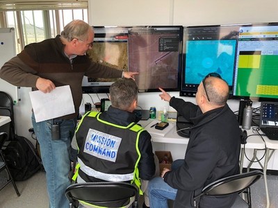
IRIS UAS program director Paige Cutland uses the IRIS UAS airspace situational awareness application to monitor the progress of a drone on a beyond line-of-sight (BVLOS) mission from a portable ground control station set up in a trailer.
Kongsberg Geospatial has been providing software design assurance to meet the certification requirements for real-time geospatial and spatial awareness technology to support air traffic management, air defense applications and unmanned systems for nearly three decades.
Their IRIS UAS situational awareness application had its genesis in supporting military UAV flight operations and was developed to help operators safely pilot UAVs in BVLOS operations. It was also used by regional airspace UTM managers to monitor the operations of multiple drones simultaneously.
The DO-278A standard (Guidelines for Communication, Navigation, Surveillance and Air Traffic Management [CNS/ATM] Systems Software Integrity Assurance) is the primary standard used by certification authorities such as FAA, EASA and Transport Canada to provide the assurance of software contained in non-airborne CNS/ATM systems. Unmanned systems manufacturers that build ground control stations for commercial drone systems, and airports and port authorities that create airspace control systems are anticipated to have to meet this standard when designing and building new systems.
By developing an airspace awareness application that satisfies this standard, Kongsberg Geospatial has provided a key component for unmanned systems manufacturers, airport operators and port authorities that wish to develop ground-based monitoring systems that are safe and certifiable for commercial operations.
“Unmanned Traffic Management and safe airspace operations will require certification of technology,” said Ranald McGillis, president of Kongsberg Geospatial. “We believe providing a certifiable airspace application will dramatically increase the safety of unmanned flight operations wherever it’s in use.”