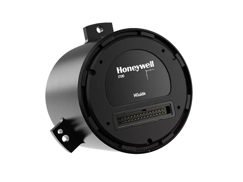
Honeywell has launched the HGuide i700, an inertial measurement unit (IMU) that delivers high-accuracy performance for unmanned air, land and sea vehicles. By pairing near navigation-grade capability with a no-license-required (NLR) classification, the HGuide i700 provides integrators worldwide with a powerful new option for critical sensing and navigation.
The HGuide i700 uses high reliability sensors and electronic architecture found in Honeywell’s HG3900 inertial measurement unit (IMU). Compact and low power, the HGuide i700 delivers near-navigation-grade accuracy and reliability while being optimized to support longer range navigation in GNSS-denied environments
“As customers explore new autonomous, robotic and precision-guided solutions, they want the accuracy and reliability of inertial systems that can be tailored to their program requirements,” said Matt Picchetti, vice president and general manager, Navigation and Sensors, Honeywell Aerospace. “The HGuide i700 offers strong GNSS-denied performance for by limiting maximum acceleration and spin rates in a license-free package that simplifies the complexity of system development while preserving reliability.”
The latest in Honeywell’s HGuide suite of no-license inertial solutions, the HGuide i700 allows customers to streamline development cycles, simplify system architecture and transition to field deployment more quickly than existing technology.
The HGuide i700’s rugged design, compact size and low-power profile make it suitable for diverse commercial, industrial and defense applications, such as:
Unmanned aerial, land or sea vehicles
Mobile mapping and surveying systems
Long duration unmanned ground or surface platforms
Robotics and industrial automation
Stabilized payloads and pointing systems
Honeywell has been a top innovator in IMU technology for more than three decades and pioneered the use of MEMS technologies in navigation. For more information about the Honeywell HGuide i700 and Honeywell’s navigation solutions, visit Honeywell Aerospace.
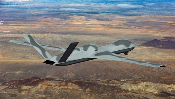
One of the top dogs in the mil-spec UAV world, General Atomics Aeronautical Systems Inc. (GA-ASI) has developed and built several jet-powered demonstration UAVs known as the MQ-20 Avenger, which is currently being used to test out new U.S. Navy communications systems. Derived from the MQ-1 Predator and MQ-9 Reaper, the Avenger is equipped with a Pratt & Whitney turbofan jet engine, allowing it to reach speeds of around 400 Knots at an altitude of up to 50,000 ft.
Predator C Avenger UAV. (Photo: GA-ASI)
After extensive testing since its first flight in April 2009, a larger extended range (ER) version began test flights in 2016. The extended range version has longer wings and an increased fuel capacity with a range of 2,000 miles and an endurance of 20 hours. Avenger has several stealth features, including an S-shaped engine exhaust and an internal weapons bay for precision weapons and sensor packages, similar to the F-22 Raptor and F-35 Lightning front-line fighters. Another recent project saw F-35 technologies passed onto the same jet-powered UAV platform.
The recent Navy communications trials were used to prove the new space-based comms capability and to remotely adjust Avenger’s autonomous internal navigation system while in flight. The aircraft has been designed for long-range, high altitude, speedy, autonomous penetration of enemy areas and this latest capability allows operations where the run-in-to-target phase can be redirected in the very last minutes of an attack. Enemy radar tracking and defenses might, therefore, be misaligned at a crucial phase of an incoming drone alarm without sufficient time to re-align and protect the actual target.
Space-based communications, in this case, used signals via the Proliferated low-Earth orbit (LEO) system of satellites, which is reportedly a mil-spec LEO constellation of communications. satellites — somewhat related to the orbits of the Space-X commercial Starlink LEO internet satellite system.
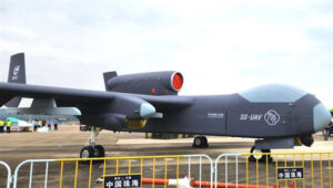
While we are in the military domain, a recently displayed Chinese development is being claimed to be a jet-powered ‘mothership’ UAV. The concept is that the carrier aircraft travels longer distances and releases a swarm of short-range drones when within range of their target(s) — a possible mock-up of such a vehicle was shown before a recent Chinese airshow.
Jiu Tian mothership UAV mock-up. (Photo: Chinese internet)
The center section of the UAV appears to be detachable or has large opening doors – the Chinese and English inscriptions on it imply that it is a module for carrying drones. There have been other reports that Chinese military thinking includes the deployment of large swarms of drones to attack multiple targets simultaneously. However, The Jiu Tian UAV does not come with a stealthy design.
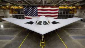
In light of the recent competition between the U.S. and China, an article about the new U.S. Air Force B-21 stealth bomber has been published. The article suggests that, given the F-35 stealth fighter-bomber’s exceptional stealth capabilities and its ability to carry and release multiple weapons from an internal bay, the B-21 may already face obsolescence.
So then, why not re-purpose the B-21 to be a drone-carrying mothership that could, while undetected, penetrate enemy defenses to release swarms of U.S. attack drones?
B-21 next generation Stealth bomber. (Photo: U.S. Air Force)
Currently, a part of the U.S. three-pronged nuclear delivery deterrents alongside submarines and ballistic missiles, the Air Force believes that the role of the existing B-2 Spirit bomber is not obsolete, and the B-21 should become operational as planned in the 2030s with its new stealth and suite of high-end technology sensors and control systems.
The concept of a Chinese “mothership” is designed to transport drone swarms close to targets before launching them. Additionally, there may be a stealthy response from the US, utilizing low-Earth orbit (LEO) satellites for space-based communications to adjust the routing of autonomous drones. This approach raises the question of whether it could be used to deceive drone defenses during the terminal phase of an attack. These solutions are complex but could significantly enhance the effectiveness of future military drone operations.
The miniVUX-2UAV airborne laser scanner. (Photo: Riegl)
The Riegl miniVUX-2UAV is a lightweight airborne laser scanner designed specifically for integration with unmanned aerial vehicles and systems.
Riegl added the new miniaturized UAV sensor to its portfolio of professional solutions for UAV-based surveying.
The sister type of the miniVUX-1UAV sensor, the miniVUX-2UAV offers 100 kHz and 200 kHz PRR. With the 200-kHz PRR, the sensor provides up to 200,000 measurements per second, and thus a dense point pattern on the ground for UAV-based applications that require the acquisition of small objects.
The Riegl miniVUX-2UAV makes use of Riegl waveform lidar technology, allowing echo digitization and online waveform processing. Multi-target resolution is the basis for penetrating dense foliage, and the wavelength is optimized for the measurement of snowy and icy terrain.
In addition to the stand-alone version of the miniVUX-2UAV, Riegl also offers fully-integrated solutions.
NASA’s UTM. On May 25, the Federal Aviation Administration (FAA)-designated Nevada UAS Test Site and its NASA partners flew five different unmanned aerial vehicles (UAVs) to test NASA’s Unmanned Aircraft System Traffic Management (UTM).
The flights demonstrated multiple operational scenarios, including parachute-initiated emergency supply deliveries and aerial survey operations.
The UAVs were flown beyond the pilot’s visual line of sight (BVLOS) using strategically placed visual observers and sophisticated command and control, communication and detect-and-avoid technologies.
The test is part of a three-week national campaign, which NASA is leading in close collaboration with the FAA and industry partners on a more complex version of its UTM technologies at six different UAS Test Sites around the nation.
Demonstration in France. In France, Delair-Tech flew a UAV for 30 miles, simulating powerline inspection. Delair used a regular, commercial 3G cellphone network to control the drone for the test — an innovative demonstration that long-distance drone operations can be safe and simple to achieve.
Canadian Deliveries.Drone Delivery Canada Corp. (DDC) hit a pivotal milestone toward commercializing its drone logistics platform after achieving BVLOS in test flights. Systems tested include DDC’s FLYTE management system, avoidance technology and communications platform.
During flights in Alberta, DDC’s Mission Control Centre in Toronto, 2,500 kilometers away, successfully monitored and record telemetry in real time. DDC could become the first drone logistics-compliant operator approved by Transport Canada.
The government of Australia has launched the first $50 million Defence Cooperative Research Centre (CRC), announced July 6 by the minister for Defence Industry, the Hon Christopher Pyne MP.
The Defence CRC is a collaborative program that brings together academia, publicly funded research agencies and industry (particularly small to medium enterprises) to create an interlocking research and innovation capability focused on driving a Defence outcome.
The first Defence CRC will focus on Trusted Autonomous Systems to deliver game-changing unmanned platforms that ensure reliable and effective cooperation between people and machines during dynamic military operations.
“Existing autonomous and robotic systems that operate in the manufacturing and mining sector are effective in controlled environments, but not suitable for the uncertain situations in which Defence operates,” Pyne said.
“To be effective, Defence needs autonomous systems to be highly trusted, robust and resilient and this initiative will bring together the best researchers from industry and universities to develop the intelligent military platforms of the future.”
The CRC for Trusted Autonomous Systems will receive annual funding of $8 million with a maximum of $50 million over a seven-year period.
The CRC will be chaired by Jim McDowell, a businessman who has had an extensive career in the defence industry, and most recently at the University of South Australia.
“As Chair, Mr. McDowell will be responsible for leading the development of the research program and business plan and work with industry on transitioning the research results into capability outcomes,” Pyne said.
This is the first of several CRCs that the Australian government is announcing. Further CRCs will be established on projects also aligned with priorities in the country’s Next Generation Technologies Fund.
Defence will be a member of each CRC along with universities, research agencies and industry. Participating members will be selected on the basis of their research excellence and technology expertise.
“The CRC environment offers excellent synergies for Defence, industry and universities to collaborate closely on Defence innovation,” Pyne said.
The CRC is an initiative of the Next Generation Technologies Fund which complements the Defence Innovation Hub as the two core initiatives of the new Defence Innovation System outlined in the Government’s Defence Industry Policy Statement. These two signature innovation research and development programs, together with the Centre for Defence Industry Capability, deliver on the Government‘s $1.6 billion commitment to grow Australia’s defence industry and innovation sector.
At the Royal Navy’s Unmanned Warrior demonstration, Insitu showcased its newest wide-area maritime surface search and identification technology for representatives from the Royal Navy as well as military and industry officials from across the globe.
During the event, held in Benbecula, Scotland, the Insitu team was tasked to perform a range of maritime missions using ScanEagle equipped with the ViDAR payload. Developed in collaboration with Australia-based Sentient Vision Systems, ViDAR is a maritime surface search with automatic target finding capability on a group two unmanned platform.
ScanEagle with ViDAR. (PRNewsFoto/Insitu)
ScanEagle flew more than 55 hours, covering an area more than twice the size of Wales (41,500 km²) and using fewer than eight gallons of fuel.
Despite sometimes challenging weather, ScanEagle with ViDAR autonomously detected hundreds of large and small objects in sea state six conditions. These included spotting and positively identifying two mine sweepers by number, spotting smaller objects such as stationary jet skis and buoys at 5 nm and locating 28 contacts from one sortie in fewer than two hours.
ViDAR successfully and reliably detected objects through changing environmental conditions ranging from clear sun to wind, rain, haze and fog.
ScanEagle flew more hours than any other participating platform.
“During one flight our team spotted a target 19 nm away before the exercise began,” said Suzanne McNamara, vice president of business development for Insitu. “ScanEagle with ViDAR is a force multiplier that will establish a new standard for global navies. We are extremely proud of the successes we achieved during Unmanned Warrior and look forward to supporting our customers with this advanced capability.”
In May, Sentient and Insitu confirmed the signing of an exclusive global distribution agreement for the ViDAR software for unmanned systems within the small UAS weight class. ScanEagle is the first and only unmanned platform to fly this payload.
VectorNav’s new Tactical Series includes the VN-110 IMU/AHRS, the VN-210 GPS/INS and the VN-310 dual-antenna GPS/INS.
VectorNav Technologies, manufacturer of embedded navigation solutions, has introduced the Tactical Series, a next generation family of high-performance Inertial Navigation Systems (INS).
The announcement was made at AUVSI’s Xponential 2016, being held this week in New Orleans, Louisiana.
Built on a common tactical grade proprietary MEMS inertial sensing core, the Tactical Series includes the VN-110 inertial measurement unit and attitude heading reference system (IMU/AHRS), the VN-210 GPS-aided INS (GPS/INS), and the VN-310 dual-antenna GPS/INS.
The Tactical Series leverages VectorNav’s navigation algorithm expertise and extensive experience in integrating its industrial series products into a broad range of airborne, marine and ground-based platforms. As a result, the Tactical Series offers the same functionality and features as Industrial Series for integrators of SWaP-C (size, weight, power and cost) constrained manned and unmanned systems.
Designed and engineered at VectorNav’s headquarters in Dallas, Texas, the Tactical Series takes advantage of the latest developments in solid state MEMS technology to incorporate a 3-axis gyro with <1˚/hr in-run bias stability, leading to an attitude accuracy of 1 to 2 mrad. In addition to the improved IMU core, the Tactical Series enclosure is designed to DO-160G standards and rated IP68 for deployment in harsh and extreme environments.
“The Tactical Series is the culmination of many years of development effort and collaboration with systems integrators across a broad range of industries,” said VectorNav President John Brashear. “We have combined our digital filtering expertise and experience in solving the challenging navigation requirements of customers worldwide to develop what is truly a next generation navigation solution.”
The Tactical Series addresses navigation needs for a variety of unmanned applications and will be on display at VectorNav’s booth (#1043) at XPONENTIAL 2016 in New Orleans, May 3-5.
Virtually all unmanned systems, from drones to autonomous vehicles, use GPS location technology and advanced mapping. As systems evolve, and enemy threats become more sophisticated, new requirements are emerging. The U.S. military is out in front of this trend, developing unmanned autonomous systems at an even faster pace, with more ambitious goals, than the civilian market. This is borne out by several recent tests and announcements, all profiled individually at env-gpsworld-integration.kinsta.cloud. This month’s column rounds up their essential details for a skyview of the burgeoning field.
Publisher’s note: Defense PNT columnist Don Jewell will return next month.
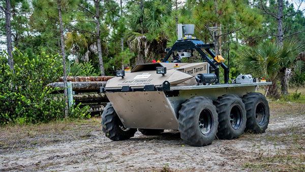
An unmanned Black Hawk delivers an autonomous ground vehicle to a remote site in a demonstration for the U.S. Army of a joint robotic air-ground mission.
Carnegie Mellon University and Sikorsky Aircraft used an autonomous helicopter and an autonomous ground vehicle to demonstrate that ground and air robots can perform complex, cooperative missions. In an October 2015 demo, an unmanned Black Hawk helicopter picked up an unmanned ground vehicle (UGV), flew a 12-mile route, delivered the UGV to a ground location and released it.
The drop-zone collaboration promises to keep warfighters out of harm’s way. For example, this type of robotic mission could avoid warfighters’ exposure to hazardous conditions, such as chemically or radiologically contaminated areas.
The Black Hawk was equipped for autonomous operation by Sikorsky, a Lockheed Martin Co. It delivered a Land Tamer autonomous unmanned ground vehicle from Carnegie Mellon’s National Robotics Engineering Center to a remote site, where the vehicle performed environmental monitoring for potential contamination.
“We were able to demonstrate a new technological capability that combines the strengths of air and ground vehicles,” said Jeremy Searock, NREC technical project manager. “The helicopter provides long-range capability and access to remote areas, while the ground vehicle has long endurance and high-precision sensing.”
Once the helicopter lowered the vehicle to the ground, the Land Tamer drove itself off its transport platform to commence its leg of the mission. The vehicle, equipped with sensors for detecting chemical, biological, radiological or nuclear contamination, then found and surveyed several potentially contaminated sites, autonomously traversing six miles in the process. When the vehicle sensors detected potential contamination, operators were able to switch the vehicle from autonomous operation into a tele-operated mode for a more detailed exploration of the site.
A JPADs pallet lands on target, followed by several others still in the air, during recent testing. (Photo: US Army)
The U.S. Army’s Joint Precision Airdrop System (JPADS) has developed a new capability with a navigation alternative to GPS. In recent tests, JPADS were dropped from planes, and immediately determined their location using optical sensors to compare local terrain with commercial satellite imagery. The new system demonstrated navigation to its intended point, using nothing but imagery to guide it.
JPADS, largely guided by GPS, has already proven its importance in supplying troops with necessary materials and equipment, relying less on vulnerable convoys. However, the new JPADS also works with little knowledge of the aircraft’s location at the drop point.
Dropping critical supplies from the air has allowed the U.S. military to rely less on easily-ambushed truck convoys and helicopter resupply. Exposure to improvised explosive devices (IEDs) and ambushed convoys resulted in more than 3,000 causalities in Afghanistan and Iraq through 2007.
JPADS has proven to be an important tool in the Army’s logistics chain in many scenarios to supply troops with material and equipment in adverse terrain and remote locations when ground lines of communication are not possible or deemed too high a risk.
“This is a huge step forward for aerial resupply,” said Chris Bessette, Draper’s JPADS program manager. “By enabling the system to operate using imagery alone when dropped as high as 25,000 feet above Mean Sea Level and upwards of 20 miles away from the target depending on winds, we can ensure that JPADS is even more versatile so troops receive supplies like fuel, ammunition, food, and water in the safest manner possible.”
In August, U.S. Army Gray Eagle unmanned aircraft took part in manned-unmanned teaming exercises in South Korea, including streaming video and metadata to an AH-64 Apache helicopter while in flight. The MQ-1C Gray Eagle proved its ability to conduct operations in diverse weather condition, according to manufacturer General Atomics Aeronautical Systems (GA-ASI). The Gray Eagle is used by the Army for reconnaissance, surveillance, communications, convoy protection, IED detection and precision weapons delivery.
During the exercise, the Gray Eagle UAS streamed video and metadata via a line-of-sight data link directly to the helicopter from extended distances. The Apache then retransmitted the imagery to a One System Remote Video Terminal (OSRVT), allowing field commanders within the Tactical Operations Center (TOC) to receive both live Gray Eagle streaming video and retransmitted video sent by the Apache. Once the Gray Eagle was airborne, U.S. ground forces passed contact reports and target coordinates to operators in the aircraft’s ground control station. The operators were then able to direct the Gray Eagle’s sensors to positively identify and track the targets.
A V-Bat UAV from Martin UAV. Applications include aerial mapping, border patrol, shipboard operations and others.
Worldwide threats will make robotic and autonomous systems’ development important for decades, according to officials speaking at the Unmanned Systems Defense conference late last year.
GPS World’s contributing editor Kevin Dennehy wrote, “Because America has been at war for more than 14 years, unmanned technology has been developing at a rapid rate, perhaps even faster than emerging autonomous commercial systems. The replacement of even manned aircraft has some in the military establishment wary, but others know it’s only a matter of time before most vehicles, surface ships and aircraft are unmanned.”
The Secretary of the Navy said its current manned fighter plane, scheduled to see activity from now until 2037, may be its last to carry an actual human pilot.
The Navy’s Kraken drone munitions delivery system begins its mission underwater,then explodes past the surface to operate in the air. The Air Force also is developing small drones that can be launched and recovered by a larger aircraft after a mission is complete.
An Army initiative called Leader Follower includes rudimentary autonomous convoy operations capability with GPS and base mapping systems, autonomous steering and braking. Army program managers say the program is in staffing, but should be approved in a few months. A full-blown Automated Convoy Operations capability would allow any manned system, including tanks and mobile artillery, to operate autonomously. Last year, the Army and Lockheed Martin successfully demonstrated a driverless line-haul convoy with seven military trucks at speeds up to 40 mph.
Talking about a new generation
Lt. Gen. Michael Williamson, U.S. Army deputy to the assistant secretary of defense for acquisition, said the service is divesting its aging robotics and drone systems, which means future contracts for defense companies. “In 14 years of war, we have rode this equipment pretty hard,” he said. “We believe in modernization, but also looking to buy new systems, which is a new shift in order to gain a competitive advantage over our enemies, who are leveraging unmanned systems.”
The Defense Department recently established the Defense Innovation Unit, based in the San Francisco Bay area, to take advantage of rapid autonomous developments in the Silicon Valley.
Virtually all unmanned systems, from drones to autonomous vehicles, use GPS location technology and advanced mapping. As systems evolve, and enemy threats become more sophisticated, new requirements are emerging.
A surrogate LDUUV is submerged in preparation for a test to demonstrate the capability of the Navy’s Common Control System at the Naval Undersea Warfare Center Keyport in Puget Sound, Washington. (U.S. Navy photo)
In December 2015, the U.S. Navy tested its newly developed Common Control System (CCS) with a submersible unmanned vehicle in underwater missions in Puget Sound, Washington. The CCS successfully demonstrated its capability to provide command and control to a surrogate Large Displacement Unmanned Undersea Vehicle (LDUUV) — an underwater UAV destined for reconnaissance and surveillance missions.
CCS is a software architecture with a common framework, user interface and components that can be integrated on a variety of unmanned systems. It will provide common vehicle management, mission planning and mission management capabilities for the Naval unmanned systems portfolio. Operators used the CCS to transmit pre-planned missions via radio link to the LDUUV’s autonomous controller. In turn, CCS displayed actual vehicle status information to the operators. The vehicle was able to maneuver to the target areas and collect imagery.
“These tests proved that operators could use CCS from a single global operations center to plan, command and monitor UUVs on missions located anywhere in the world,” said Capt. Ralph Lee, who oversees the Navy’s CCS program at Patuxent River, Maryland. “This event also showed us that CCS is adaptable from the UAV (unmanned aerial vehicle) to UUV missions.”
CCS is intended to be compatible across all domains — air, surface, undersea and ground. The Navy initially plans to deploy the CCS on unmanned air vehicles. It will provide common vehicle management, mission planning and mission management capabilities for the Naval unmanned systems portfolio.
As the 2016 legislative session kicked off this month, the Association for Unmanned Vehicles Systems International (AUVSI) has been tracking all active legislation pertaining to unmanned systems. This year, to provide the best information to its members, legislators, regulators and the media, AUVSI has organized data on all unmanned systems-related state legislation into a sortable, interactive map with details that include a summary of each bill.
Included are bills that place restrictions on police, recreational or commercial unmanned aircraft systems; legislation that forms unmanned systems or autonomous vehicle commissions and task forces; bills that try to treat unmanned technology differently than other information-gathering devices; and bills that place operating limitations on unmanned aerial systems (UAS) in specific scenarios such as preventing all UAS from flying over prisons or from interfering with hunting and fishing.
To date, more than 150 active bills in more than 30 states have either carried over from 2015 or been introduced this year.
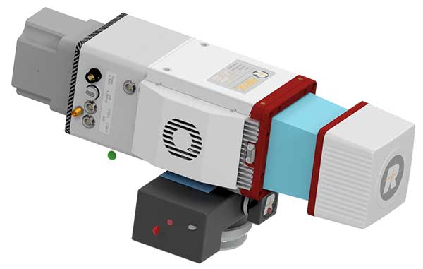
KVH’s new GEO-FOG 3D inertial navigation system (INS) continuously provides extremely accurate measurements that keep applications operating in challenging conditions. (Image: KVH)
KVH Industries has introduced the GEO-FOG 3D inertial navigation system (INS). The new product offers roll, pitch and heading accuracies of .05 degrees for demanding applications in unmanned, autonomous and manned aerial, ground, marine and subsurface platforms, such as subsea remotely operated vehicles or mining systems.
The GEO-FOG 3D is based on the company’s high-performance fiber optic gyro (FOG) technology combined with centimeter-level precision RTK GNSS receivers and advanced sensor fusion algorithms. The result is a solution that continuously provides fast, ultra-accurate position, velocity and attitude measurements that keep applications operating no matter how challenging the conditions, according to KVH Industries.
The core inertial sensor for the new system is KVH’s 1750 IMU, an inertial measurement unit incorporating three axes of KVH’s DSP-1750 FOG — a high-performance fiber optic gyro — with three axes of advanced accelerometer technology. The 1750 IMU is then fully integrated with a GNSS receiver and a three-axis magnetometer, a barometric pressure sensor and a triple frequency RTK GNSS receiver to deliver reliable, real-time, centimeter-level positioning and orientation measurements.
The system’s sensor fusion algorithms automatically switch from loosely to tightly coupled filtering for improved performance under poor GNSS signal conditions. The system also offers high-speed update rates and rapid north-seeking gyrocompass capabilities for high-accuracy heading in environments when magnetometers and GNSS-aided heading cannot be used.
The GEO-FOG 3D Dual inertial navigation system (INS) is designed for applications that require heading at system startup or in low dynamic conditions. (Image: KVH)
KVH has also introduced a variant, the GEO-FOG 3D Dual, an INS and attitude and heading reference system (AHRS). This product features two GNSS antennas on a fixed RTK baseline that offers the same reliability and performance levels as the GEO-FOG 3D, with increased heading, pitch, and roll accuracy for static and dynamic applications where single antenna systems can be problematic. The GEO-FOG 3D Dual is a superior choice for applications that require heading at system startup or in low dynamic conditions.
“KVH’s GEO-FOG 3D and GEO-FOG 3D Dual provide exceptional accuracy and outstanding performance in a single, small package (less than 1.6 pounds), at price points never previously achieved in the industry,” said Jay Napoli, KVH’s FOG/OEM vice president. “And, because KVH controls the entire design and production process, from creating its own optical fiber to packaging its FOGs together with other sensors for advanced applications, these new products — and all of our open-loop FOGs, IMUs and INSs — offer outstanding accuracy and excellent durability at a lower cost than competing systems.”
Reliable, high-accuracy navigation and control are essential to unmanned, autonomous and manned platforms that must operate in conditions that include magnetic interference and the absence of reliable satellite navigation data. The integrated FOG, GNSS and sensor fusion technologies allow the GEO-FOG 3D and GEO-FOG 3D Dual to achieve performance levels that are beyond typical INS- or MEMS-based solutions.
Both the GEO-FOG 3D and GEO-FOG 3D Dual are designed to support current and future satellite navigation systems including GPS, GLONASS, Galileo and BeiDou. Both systems offer data rates up to 1000 Hz, and the ability to output data over a high-speed RS-422 interface or RS-232 interface, which ensures the systems can be easily and readily integrated in a wide range of platforms.
In August, U.S. Army Gray Eagle unmanned aircraft took part in manned-unmanned teaming exercises in South Korea, including streaming video and metadata to an AH-64 Apache helicopter while in flight.
Exercise support was conducted from Kunsan Air Base, South Korea, and represent a milestone for the MQ-1C Gray Eagle, proving its ability to conduct operations in diverse weather condition, according to manufacturer General Atomics Aeronautical Systems (GA-ASI).
During the exercise, the Gray Eagle UAS streamed video and metadata via a line-of-sight data link directly to the helicopter from extended distances. The Apache then retransmitted the imagery to a One System Remote Video Terminal (OSRVT), allowing field commanders within the Tactical Operations Center (TOC) to receive both live Gray Eagle streaming video and retransmitted video sent by the Apache. Once the Gray Eagle was airborne, U.S. ground forces passed contact reports and target coordinates to operators in the aircraft’s ground control station. The operators were then able to direct the Gray Eagle’s sensors to positively identify and track the targets.
The Gray Eagle is used by the Army for reconnaissance, surveillance, communications, convoy protection, IED detection and precision weapons delivery.
The Bullray UAS is a fully autonomous, amphibious, man-portable tricopter/quadcopter that makes vertical take-offs and landings.
Rated IP-67, the rugged design is capable of performing in all weather conditions and doesn’t require a transit case. It can carry a significant sensor payload: GPS, FLIR cameras, lidar, metal detection systems and more.
Rapid Composites — builder of high-end UAVs for the military and first responders — custom manufactures the units. The company won the UAV category in the 2015 JEC Innovation Awards.