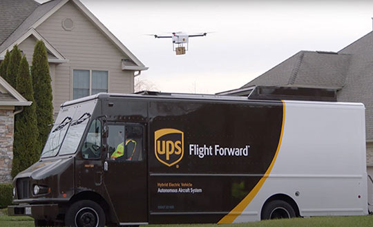
Skyward, a Verizon company, and UPS Flight Forward will collaborate to deliver retail products with drones connected to Verizon 4G LTE, as well as testing and integrating 5G for delivery.
“We will need the ability to manage and support multiple drones, flying simultaneously, dispatched from a centralized location, operating in a secure and safe environment,” said Carol B. Tomé, CEO of UPS. “To do this at scale, alongside Verizon and Skyward, we’ll need the power of 5G.”
“We’re just beginning to see how the power of 5G Ultra Wideband will transform the way businesses operate,” said Rima Qureshi, chief strategy officer at Verizon. “By partnering with UPS and other innovative companies, we can learn from each other’s expertise and collaborate to create solutions that help move the world forward.”
Photo: Verizon
In 2020, Verizon, UPS Flight Forward and Skyward started testing 4G LTE in delivery drones to demonstrate cellular reliability and performance at altitude.
“The low latency of 5G and edge compute is ideal for monitoring air traffic in and out of a busy logistics hub, especially those using mixed fleets of autonomous vehicles like drones, trucks and planes,” said Mariah Scott, Skyward President. “This year, we’ll be taking the collaboration with UPS further by testing 5G Ultra Wideband integrations to connect the sky.”
UPS has operated more than 3,800 successful drone delivery flights since the creation of UPS Flight Forward, its drone delivery company, certified by the Federal Aviation Administration in 2019. But in 2020, drone delivery emerged as much more than rapid delivery of essential healthcare items — during the global pandemic it provided high-risk seniors a rapid and contactless delivery option to remain healthy at home.
“Using Verizon’s 5G and Skyward, we’ll be able to transform the delivery experience — more personal, more on-demand and with the same safety, efficiency and reliability our customers trust today,” said Bala Ganesh, vice president, Advanced Technology Group at UPS.
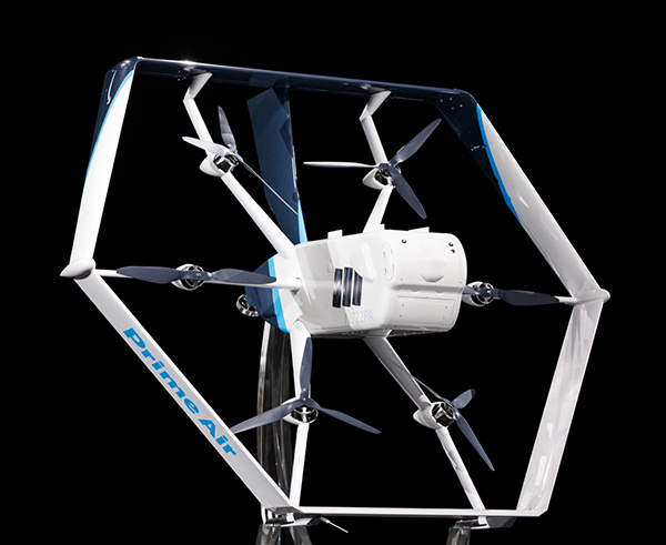
Amazon’s latest delivery drone design was unveiled in June 2019. (Photo: Amazon)
Amazon has received U.S. Federal Aviation Administration (FAA) approval to use drones to deliver packages, which Amazon says will reduce package delivery time to as little as a half-hour.
The approval will give Amazon broad privileges to “safely and efficiently deliver packages to customers,” the FAA said.
Amazon joins UPS and Alphabet-owned Wing, which previously won FAA approval for their drone delivery operations.
The approval falls under Part 135 of FAA regulations, which regulates package delivery by drone. All part 135 participants must go through a five-phase process for certification.
“The FAA is encouraging innovation through the Unmanned Aircraft Systems (UAS) Integration Pilot Program (IPP) by working with industry, state, local, and tribal governments to realize the benefits of drones, while informing future rules and regulations,” according to the FAA.
“Participants in these programs are among the first to prove their concepts, including package delivery by drone through part 135 air carrier certification. Part 135 certification is the only path for small drones to carry the property of another for compensation beyond visual line of sight.”
Amazon said it will use the FAA’s certification to begin testing customer deliveries. The company said it went through rigorous training and submitted detailed evidence that its drone delivery operations are safe, including demonstrating the technology for FAA inspectors.
Drone service slated to begin February 2020, with goals of enhancing efficacy, reliability and predictability of delivering medical products between hospitals and laboratories.
In February, the University of California (UC) San Diego Health will launch a pilot project to test the use of unmanned aerial vehicles to transport medical samples, supplies and documents between Jacobs Medical Center, Moores Cancer Center and the Center for Advanced Laboratory Medicine (CALM), speeding delivery of services and patient care currently managed through ground transport.
Trained professionals will load and operate the drones, which will follow predetermined, low-risk flight paths and will carry no cameras. (Photo: UC San Diego Health)
The program is a collaboration with UPS, which received in September 2019 the Federal Aviation Administration’s (FAA) Part 135 Standard certification and authorization to use unmanned aircraft systems for a drone delivery program, and Matternet, a Mountain View, California-based drone systems developer for health care institutions. This latest effort builds upon the UPS and Matternet drone project already taking place at WakeMed Health and Hospitals, a private, non-profit health care system based in Raleigh, N.C.
“Currently, medical samples that must be transported between health care sites are carried by courier cars, which are naturally subject to the variabilities of traffic and other ground issues,” said Matthew Jenusaitis, chief administrative officer for innovation and transformation at UC San Diego Health. “With drones, we want to demonstrate proof-of-concept for getting vital samples where they need to be for testing or assessment more quickly and simply. It’s another way to leverage emerging technologies in a way that can tangibly benefit our patients.”
The project calls for medical professionals at Jacobs Medical Center, located on the east health campus of UC San Diego in La Jolla, to pack payloads, such as blood samples or documents, into a secure container that attaches to one of Matternet’s M2 rechargeable battery-powered drones.
The drones will follow predetermined, low-risk flight paths, initially between Jacobs Medical Center and special landing sites at Moores Cancer Center, located less than a mile away and within visual line of sight under the FAA’s Part 107 rules, and then subsequently at CALM, which is near the Jacobs Medical Center. The flights will take only minutes to complete and will be monitored by remote operators. The drones will carry no cameras.
In May 2018, the FAA designated the city of San Diego as one of nine lead participants in the regulators’ Integration Pilot Program. UC San Diego was also approved by the FAA to test the use of drones in transporting lab specimens and pharmaceuticals throughout its health system.
“Right now, most biological samples must travel between sites by courier car, within designated hours,” said James Killeen, MD, clinical professor of emergency medicine and director of information technology services at UC San Diego School of Medicine. “That leaves the system vulnerable to the vagaries of road congestion, accidents, construction and more. Travel time can be slow and unpredictable. A drone can fly over such obstacles in a much more direct way, and take just a few minutes to cover the same distance.”
From growing crops to making movies, unmanned aerial vehicles (UAVs) are changing the way we work. UAVs — managed by unmanned aerial systems, or UAS — range from small indoor inspection units to giant Predator drones. They are streamlining how we manage mines and plants, deliver packages, and keep people safe. Read on to find out the latest in this skyrocketing market.
The unmanned aerial system (UAS) industry is in great shape! In the United States., the Federal Aviation Administration (FAA) appears to be helping commercial operations get off the ground, at least for those wishing to fly small unmanned aerial vehicles (UAVs).
Things are certainly hopping for unmanned aircraft in agriculture, mining and construction, facility inspection, newsgathering, movies and promotion. Package delivery is on the way, and, of course, defense is cooking with new innovations. Everywhere you look, a specialized drone or new application seems to appear that has good prospects for success.
One helpful aspect of today’s landscape for UAS operators in the U.S. is the FAA’s supportive approach to small UAS (sUAS) for commercial activities. After providing a regulatory framework with Part 107 rules, albeit with quite a few caveats that require a written waiver application, qualified drone operators are now able to fly their drones in many places — as long as they are below 400 feet, well away from airports, and nowhere near any restricted airspace.
Pilot qualification courses and proficiency testing are both readily available — at 676 commercial facilities across the U.S. according to the FAA website — and a successful online application process should result in a remote pilot’s certificate.
With a drone registered with the FAA, you can use the FAA’s B4UFLY mobile app to check if it’s safe to operate where you intend to. If it is, you can get approval in real time using the FAA’s Low Altitude Authorization and Notification Capability (LAANC) system. The FAA qualified LAANC to clear commercial drone operations, and the service is now provided by a large number of independent UAS service providers.
With the regulatory and approval path in place, it’s now possible for companies and individuals to earn a living with turn-key drone operations, providing services for many applications that have blossomed. There’s work to do beforehand, but it’s less arduous than for manned flight operations.
Let’s look at a few of the applications benefiting from the automation, enhancement and remote operations provided by UAVs as well as their on-board sensor suites and after-flight processing:
agriculture
mining and construction
facility inspection
newsgathering, movies and promotion
package delivery
defense
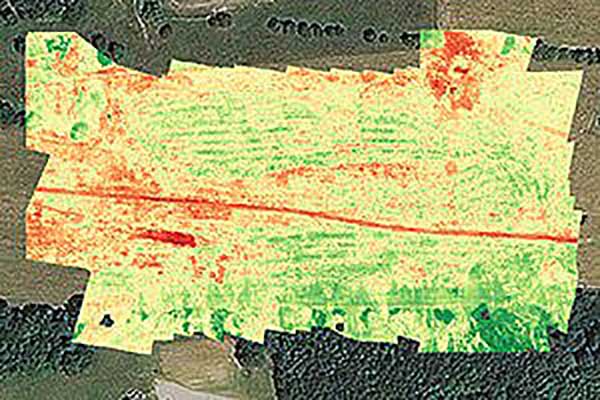
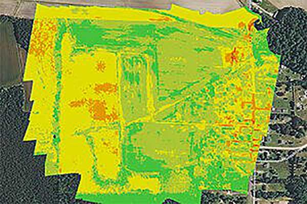
Crop health analysis: Precisionhawk’s software PrecisionAnalytics—Agriculture automatically generates georeferenced orthomosaics from data collected with drone sensors. (Map: PrecisionHawk)
Agriculture
Agriculture has readily adopted UAVs to monitor, control and improve overall crop growth rates — a part of what is known as precision agriculture. Drones carrying optical, thermal and laser scanning payloads gather stacks of information about the condition and rates of growth in fields. The information is then fed into various analysis tools. A picture emerges over time that indicates the health of crops. This enables farmers to generate a formulas for the nutrient and weed-reduction chemicals used for spraying at various times of the year. It’s a customized “prescription” for each growing area.
Continuing UAV overflights during the growing cycle monitor the effects of growing conditions and the effectiveness of treatments, providing more feedback that lead to even further improvements.
Smaller tech-savvy farms might run their own programs, supported by local agrochemical suppliers that may provide analysis services or sell analysis tools.
However, there has been a real growth in the number of companies that supply an entire turn-key package — supplying and flying drones, gathering data, running analyses and providing written and graphic output to support the farming operation.
Unmanned aircraft are truly an integral part of this approach, which might only have been possible because of semi-autonomous UAS and the evolution of compact sensors: UAV-mounted infrared, high-precision optical and lidar.
A sample prescription map. (Map: PrecisionHawk)
Mining and Construction
Any mine site is a busy — even chaotic — place to conduct a commercial business.
Drones provide a way for mining operations to:
quickly collect information to enable volume calculations;
provide relatively inexpensive site surveys; and
manage traffic and set up daily road layouts.
In effect, drones enable more rapid control of a complex and dynamic undertaking. Additionally, they improve safety. Ground surveyors no longer need to dodge huge operating machines and tumbling ore, or scramble around difficult terrain.
An autonomous drone can gather timely, georeferenced imagery that can be turned into a precise 3D model of the site. Site managers can have immediate access to details of the UAV survey. They can see the extent of existing deposits and know where to support further mineral exploration, receive estimates of stockpiles and tailing volumes, ensure that personnel and equipment are in the correct locations, and compare aerial video and photography day by day to check progress and for record-keeping. Drones can carry a wide variety of imaging and sensor packages including visual, infrared, hyperspectral, lidar, sonar and radar.
It’s also quicker. For instance, using the senseFly eBee fixed-wing drone, a full aerial survey of an 88-hectare site took four to five hours, with about half of that time spent placing control points. To achieve the same level of detail, terrestrial surveying would take a single surveyor two to three weeks.
Construction Operations. The construction sector uses the same drone data-capture techniques for site details, off-line analysis and results tabulation to manage operations of complex work sites. Compared to mining, change can be more intensive during a construction project, so drone surveys might be repeated more often.
Surveying and GIS. Using drones is an industry unto itself, with high-precision RTK GNSS in the air and on the ground, and specialized analysis tools for high-accuracy applications. The speed of data gathering is the principal benefit to an industry that continues to be essential in many sectors. Lower precision GIS for asset tracking and the like could become a subset of the applications and tools already discussed.
Facility inspection. Outdoor and indoor facility inspection is definitely benefiting from the automation that suitably equipped drones and customized analysis tools can bring to both regular and infrequent inspection tasks. The number of regular complex refinery inspections can be significantly reduced. Inspections will no longer interfere with production and will improve safety for inspection staff. For instance, flame stacks that burn off excess gases can be prone to failure, so regular inspection is essential. Using a drone for the task is clearly much safer than using personnel.
An offshore oil and gas construction platform vents gases to relieve pressure. Flame stacks such as these require regular inspection. (Photo: Oil and Gas Photographer/Shutterstock.com)
BVLOS for Pipelines and Rail
Automated pipeline and railway track inspection have both become possible as drones are used over much greater distances, thanks to beyond visual line of sight (BVLOS) operational approvals by the FAA.
For BVLOS, users first need a validated sense-and-avoid technology on the drone. Also required is proven radio telemetry with uninterrupted command-and-control of the vehicle during flight, and an independent ground-monitoring system that confirms how the drone maneuvers throughout the flight.
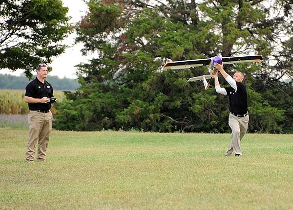
In the case of a BVLOS flight this summer along the Trans-Alaska oil pipeline, a Perimeter UAV manufactured by Skyfront flew about 4 miles, maintaining a constant above-ground altitude of 400 feet with multiple ascents and descents of 1,000 feet on 45-degree slopes. The long-range hybrid multicopter drone was equipped with Iris Automation’s computer vision collision-avoidance system and was monitored by
Launching a UAV for a BVLOS flight are (at left) Travis Balthazor, UAS flight operations manager, and Mike Kuni, UAS flight instructor/pilot, both of Kansas State University Polytechnic Campus. (Photo: KDOT, Division of Aviation)
Echodyne radars along the pipeline path, providing airspace situational awareness.
Another BVLOS operation built on the achievements of the Trans-Alaska pipeline trial has been authorized to fly a nine-mile linear inspection of power lines in rural Kansas.
Once again, the Iris Automation system will provide collision avoidance, but this drone also has an independent automated avoidance capability. This gives the drone the self-contained ability to fly around obstacles, so no ground radar or visual tracking is required.
Relieving the requirement for radar tracking or visual observers makes many new operations affordable. Previously, FAA Part 107 BVLOS waivers have all required visual observers or ground-based radar tracking — requirements that are not only expensive, but also restrict where flights are possible.
BVLOS operations like these demonstrate the cost-effectiveness of the technical solution, making long-duration, long-distance inspection using drones feasible.
Indoor inspection is becoming possible with specialized drones that circumvent the need to expose inspection staff to especially difficult facility environments, which in the past also required production shut-down to protect them. Thermal and visual sensors on swivel mounts enable protected inspection drones to fly into tight spaces — or even back out of tricky situations — and make visual records that may otherwise be virtually impossible.
Searching and recording inside containment vessels at the failed Fukushima nuclear facility may have been significantly advanced by using inspection drones.
Newsgathering, Movies and Promotion
All those panoramic, overhead, moving shots you see on the news, in movies and in ads used to be taken from a manned helicopter or fixed-wing aircraft. Now they are mostly taken by multi-copter drones with high-resolution cameras. This makes cinematography and newsgathering much more affordable, making these fields accessible by smaller operations. In the past, only large media groups could afford to rent a helicopter. And, of course, it’s much quicker to bring a UAV onto an incident site, operated by a crew on the ground.
You’ll need FAA approval to use a drone for commercial newsgathering purposes, or find a suitable qualified UAV and operator. After gaining FAA qualifications, news people are also taking on the job, buying and flying the equipment and managing the video-processing software themselves.
Others using drones for similar purposes are movie makers, producers of TV commercials and real estate agents, to name a few.
Delivery by Drone
The ultimate objective of many internet suppliers is to deliver goods that were just ordered within minutes of the order being placed. This is a pretty big objective. It requires a whole network of “fulfillment centers” in and around many cities, a massive purchasing and goods movement capability to keep these centers stocked, and a system that delivers to the end-customer. Currently, we mostly have manned panel trucks of various flavors handling that last step of the delivery process, with real people reading the notes we put on the porch about where to leave our package if we’re out.
Order and Receive. The next wave of delivery changes are expected to include drones carrying your package from the fulfillment center to your backyard. Amazon is looking for approval to begin trials with its larger 88-pound MK-27 Prime Air delivery drone, initially in sparsely populated areas. The MK-27 is equipped with intelligent sense-and-avoid capability, flying around any obstacles it encounters in flight and even during delivery.
UPS is also hoping to get to qualification of its own UAS delivery system by the end of this year, to the same standards that manned aircraft delivery systems are certificated.
Medical Deliveries. Many other trials are underway, especially involving medical deliveries and support. In Africa, trials are underway in Ghana, Malawi and Rwanda. UPS recently proposed a medical supplies delivery service using drones in North Carolina. Many companies that claim expertise in medical deliveries are operating drones.
Food on the Fly. Restaurant food delivery services have seen an upsurge in popularity. It seems likely that soon you’ll be able to order and receive lunch really quickly by drone food delivery services. Ground robot food deliveries at George Mason University are already a huge hit! Uber-Eats is experimenting with drone food deliveries, and 17 drone delivery routes have already been approved in an industrial park in Shanghai.
Meanwhile, Bell has flown its autonomous pod transport (APT) 70 near its base in Fort Worth, Texas, for the first time. The APT 70 can carry a 70-pound package load at over 100 mph, far faster and farther than existing drone delivery systems.
Bell is aiming for package delivery and critical medical transport for disaster relief for APT type drones. It is also participating in the NASA SOI program along with General Atomics’ SkyGuardian.
Drones are a new tool. The UAS industry will continue to change and adapt these products and this technology in as-yet-unthought-of ways. It’s an exciting time, and right now, there seems to be no end in sight.
For a look at drones in the defense industry, see Murfin’s article “Defense in front of UAV development,” published in September’s Professional OEM + UAV newsletter.
The United States Federal Aviation Administration (FAA) has awarded air carrier and operator certification to UPS Flight Forward, an unmanned aircraft system (UAS) delivery company.
Through the DOT’s UAS Integration Pilot Program, the FAA has now approved a Part 135 operating certificate for UPS Flight Forward. This allows the company to perform revenue-generating package delivery activities within federal regulations.
UPS Flight Forward may now operate multiple drones under one certificate. Under Part 135, the company can deliver vital healthcare supplies including by flying beyond visual line of sight.
The UPS subsidiary immediately launched the first drone delivery flight by any company under Part 135 Standard at WakeMed’s hospital campus in Raleigh, N.C. That flight, using a Matternet M2 quadcopter, was flown under a government exemption allowing for a beyond-visual-line-of-sight (BVLOS) operation, also a first in the U.S. for a regular revenue-generating delivery.
UPS said it has proven the need for drone delivery in healthcare operations, where the shortest time in transit can improve efficiency and help healthcare professionals better serve patients.
The medical delivery program at WakeMed is the result of testing conducted by UPS and Matternet in August of 2018 as part of their participation in the UAS Integration Pilot Program (UAS IPP).
UPS partnered with Matternet to launch its healthcare delivery service on the WakeMed campus. The revenue-generating service demonstrated the business case for drone delivery of medical products and specimens.
Now, with its Part 135 Standard certification, UPS is ready to build on this application and expand to a variety of critical-care or lifesaving applications.
Photo: UPS
“This is history in the making, and we aren’t done yet,” said David Abney, UPS chief executive officer. “Our technology is opening doors for UPS and solving problems in unique ways for our customers. We will soon announce other steps to build out our infrastructure, expand services for healthcare customers and put drones to new uses in the future.”
The company will initially expand its drone delivery service further to support hospital campuses around the country, and to provide solutions for customers beyond those in the healthcare industry.
Part 135 Standard certification enables UPS to integrate drones into the UPS logistics network, creating potential for new applications in many industries. The company has a long-term plan with milestones that include:
expansion of the UPS Flight Forward delivery service to new hospitals and medical campuses around the country.
rapid build-out of ground-based, detect-and-avoid (DAA) technologies to verify drone safety, while enabling future service expansion.
construction of a centralized operations control center.
regular and frequent drone flights beyond the operator’s visual line of sight.
partnerships with additional drone manufacturers to build new drones with varying cargo capacities.
adding new services outside of the healthcare industry, including the transport of special commodities and other regulated goods.
“UPS is committed to using technology to transform the way we do business,” said Scott Price, UPS chief transformation and strategy officer. “UPS’s formation of a drone delivery company and application to begin regular operations under this level of certification is historic for UPS and for the drone and logistics industries.”
As a participant in the U.S. Transportation Department’s Unmanned Aircraft Systems Integration Pilot Program, the North Carolina Department of Transportation (NCDOT) partnered with UPS Flight Forward. As the operator, they have been engaged in delivery of healthcare supplies around a major hospital campus in Raleigh, North Carolina. The flights have focused on the delivery of blood for potentially life-saving transfusions, as well as other medical samples for lab work.
The company demonstrated that its operations met the FAA’s rigorous safety requirements to qualify for an air carrier certificate. This is based on extensive data and documentation, as well as test flights.
“Seen & Heard” is a monthly feature of GPS World magazine, traveling the world to capture interesting and unusual news stories involving the GNSS/PNT industry.
Batman only wishes he had one
New miniature GPS “backpacks” are making it possible to track tiny desert bats, providing insight into their lives. Tiny 1-g GPS tags showed University of Helsinki researchers that Africa’s yellow-winged bats struggle during dry periods. The species is one of the few desert bats large enough to carry the tag. Researchers placed GPS trackers on 29 bats, 15 in the rainy season and 14 in the dry season, for one week each, and recorded their positions every 30 to 60 minutes each night.
Photo: iStock/ MBPROJEKT_Maciej_Bledowski
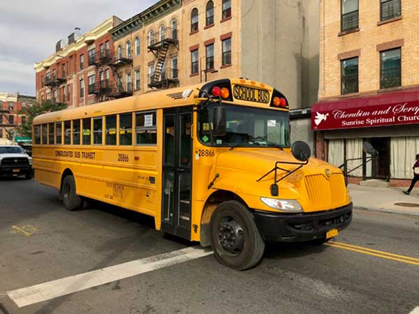
The wheels on the bus need GPS
All New York City public school buses will provide GPS tracking by the first day of class this fall. The city has teamed up with Via to install the equipment and provide an app for real-time tracking of the nearly 10,000 buses. The city council approved the tracking program after a sudden snowstorm in November 2018 left buses stranded in traffic for hours, and parents couldn’t reach their kids.
Keep on truckin’
Shipping company UPS is investing in autonomous deliveries, specifically in TuSimple, a robot-trucking startup. UPS is testing self-driving tractor trailers on a route between Phoenix and Tucson, Arizona, to help it understand requirements for Level 4 autonomous trucking. TuSimple completed a two-week pilot with the U.S. Postal Service in May, hauling mail between Phoenix and Dallas. All TuSimple trucks operate with two technicians in the cab, with the aim to operate without drivers within two years.
A+ for GPS Cows
High-school students interested in agricultural professions can now learn about the use of GPS for monitoring livestock, and even make their own GPS collars. The collaborative GPS Cows program brings together industry researchers, professionals and educators from the U.S. and Australia. GPS Cows is fighting the misperception that ag-focused students don’t need digital literacy, and is engaging them in agri-tech, specifically tools and systems that provide animal location and behavior data.
GPS and GNSS have changed the world. Of that there can be no doubt. But in terms of sheer change, both qualitative and quantitative — we ain’t seen nothing yet.
We now witness the creation of an industry. This will be very disruptive. We’ve had change instituted by GNSS; we know what that looks like. We haven’t yet seen a true revolution.This is something entirely new, and there are many things about which we don’t yet have a clue .
What happens to that great American institution, the private car? The relationship between the individual and its four-wheeled extension?
And on the industrial side, do automakers disappear as OEMs — do they become Tier 1 suppliers to Google, Uber and Lyft?
Because of the massive impact of this particular rollout of GNSS-enabled capabilities, I am devoting this issue of the GNSS Design & Test e-newsletter to it, even though it is not in itself a system in space. It is the most radical transformation of life on Earth we have seen, driven by our systems in space.
The following are notes jotted during the Driverless Conference, March 23 in San Francisco.
“In the early 90s, when I was part of a government ride-sharing initiative, we used to talk about these new portable devices bringing data communication into … wherever we go. Now they’re here, and they’re well established. Very soon, this is going to change things, and enable many of the things we’ve only talked and dreamed about so far.” Thus spoke Steve Wollenberg of Automatiks, opening the conference.
“We’re at the confluence of great technological developments. We’re seeing great acceleration of all of them.”
Virtually all the speakers, all these driverless enthusiasts, really love cars. Some own up to collecting them, having multiples in their home garage(s). A bit wistfully, Wollenberg foresaw the new control technology taking over public roadways. “In ten years, racetracks may be the only place where you’re allowed to drive your own vehicle.”
Ride Share. “Four years is the entire lifetime of the ridesharing industry,” said Emily Castor of Lyft, who by virtue of her tenure there for that period, can be termed an industry veteran.
“We’ve seen a full-about turn in the regulatory environment. We see ride-sharing as the stepping stone to a world in which people no longer drive vehicles. Getting an autonomous vehicle on demand through a shared network will be much easier and cheaper than owning a private vehicle.”
Lyft talked with General Motors last year, and found a shared vision of shared use.
Amitai Bin-Nun from Securing America’s Future Energy (SAFE), a non-partisan advocacy organization with business leadership, introduced his organization’s broad mission: reducing U.S. petroleum dependence. Instability in parts of the world is fueled by petroleum dependence.
“This is a hard process. It takes a long time to overturn an established system.” A key obstacle is the lack of compelling new consumer experience, currently. Using connected and autonomous vehicles in a ride-sharing network is an opportunity to get this new experience, and drive the transformative process. Re-order the transportation system.
Mariel Devisa of Travelers Insurance announced that Travelers has launched a ride-share insurance product, live now in 16 states.
In two fairly conservative industries — automotive and insurance — with long-established partners and practices, the efforts to move and change are, frankly, surprising and faster than anticipated, according to moderator Wollenberg. “It’s a fun time.”
Freight and Fleets. Steve Boyd of Peloton made the case that trucking fleets can serve a critical role in pushing the technology forward, because some segments of the transportation industry move faster than others. Getting state approvals without having to go federal is the route pursued now, in terms of full-scale roadtesting of autonomous driving. That will enable early adoption heading into commercial pathways: freight-truck platooning and drafting. Volvo, Intel, Nokia, Denso, UPS and a number of other companies are closely involved.
Boyd announced a set of fleet trials this year, starting in Texas, “a very truck-friendly state.” Legislative approval for trials has passed or is pending in several other states, as many as a dozen. Prospective customers are already lined up in the freight space.
In Europe, an April 6 EU Platooning Challenge will take place in Rotterdam. The Netherlands is leading the EU in the current cycle to approve truck platooning by early 2018.
There’s “a platooning gap” developing between the U.S. and Europe, according to Boyd. Silicon Valley may lead on the technology, but if this is not matched by activity on the regulatory side, it will lose out to other areas that aggressively pursue approvals as well as technology.
Traditionally, the automotive and trucking OEM industries have been very competitive, but now they are seeing the necessity to collaborate to push the policy side forward. This is happening in the insurance industry, too. Competition will certainly still be there, but to enable vehicle-to-vehicle communication a broad measure of collaboration will be necessary.
The road environment today is very imperfect, with many thousands of fatalities and countless more serious injuries. Trucks drive too close together. Highway safety needs innovation and regulatory change in order to improve.
The Long Vision. An autonomous car can’t count on the ability of the driver to retake control of the vehicle in 5 or 10 seconds. So the vehicle needs to be able to take care of itself — fully. Therefore, an evolutionary approach to installing autonomous capabilities may not work.
Some initiatives, however, continue to bring services into the vehicle one by one, gradually. How engaged will the driver be, and in what timeframe? There’s debate, and a shift in thinking may currently be underway.
Traditionally, a 5- to 7-year product cycle in automotive starts when new features are introduced in upmarket vehicles. Examples: adaptive cruise control (to follow the car in front of you at a set distance), lane-keeping assistance. Gradually, these new features are installed in lower price-point models until they become standard throughout the line. With multiple products and product cycles, it will thus take multiple decades. 220 million vehicles are owned by households. An integrative approach to autonomy will take a long, long time.
There is a rising tide for autonomy may take a different approach: autonomy first, that is, full autonomy will take over the vehicle — and as many vehicles as possible.
(Something that no one has mentioned but I can’t help thinking: Given the longstanding and extremely virulent controversy in this country over private gun ownership… What does this bode for something shaping up as a massive social, structural change, not just a new technological wrinkle? What is more American than a gun? A car.
If you thought the Internet, or smartphones, or for heavensakes even GPS/GNSS have radically altered the world — again, we ain’t seen nothin’ yet.)