Spencer Cox, the governor of Utah, toured Teal Drones headquarters in Salt Lake City, to learn about Teal’s operations, the company’s impact on the national aerospace and defense industries and opportunities and challenges facing Utah’s local defense industry. The visit was organized by the newly created Utah Aerospace and Defense Association (UADA).
“Teal is deepening its relationship with UADA to help accelerate the rebuilding of America’s defense industrial base, specifically for UAVs,” George Matus, Teal Drone founder and CEO said.
Teal is certified as “Blue UAS,” authorizing the company to provide equipment to the U.S. military. Teal is also one of three UAV manufacturers invited to participate in the U.S. Army’s Short Range Reconnaissance Tranche 2, designed to deliver a portable small uncrewed aerial system that can be used by army platoons for surveillance, reconnaissance duties and improving situational awareness.
UADA was established in 2022 to address challenges associated with innovation, entrepreneurship, workforce development and supply chains for companies in the aerospace and defense industries.
“For far too long, we have ceded the building of UAVs to China and other places,” the governor said. “We are bringing that back and Utah is at the center of that.”
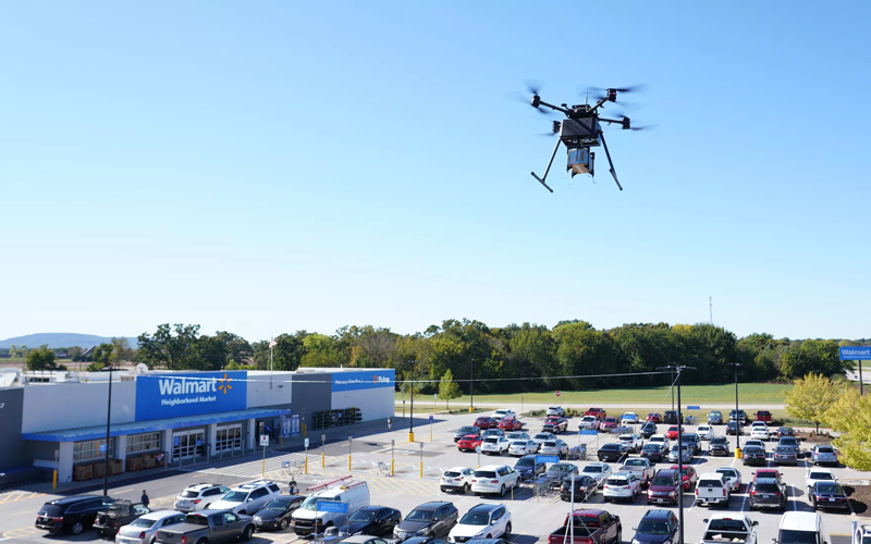
Two Walmart locations in Utah, one in Lindon and one in Herriman, are now providing UAV delivery for customers nearby. Walmart has UAV deliveries operated by DroneUp, Flytrex and Zipline at 36 stores in the United States.
For a $3.99 fee, customers within a mile of the stores can receive their groceries via UAVs. The two Walmart locations in Utah can deliver more than 120 times per day and each UAV can carry up to 10 pounds. The hubs for deliveries are in the parking lots of each Walmart location and are operated by Federal Aviation Administration-certified pilots.
Walmart is using UAV delivery in seven states, including Florida, Arizona, Texas, Utah, Virginia, North Carolina and Arkansas. The most common products delivered include ice cream, lemons, rotisserie chicken, Red Bull and paper towels, according to Walmart.
Walmart drone deliveries launched in October 2019 in Arkansas. In 2022, Walmart completed more than 6,000 deliveries across all 36 participating locations.
“Addresses are created by local address authorities in city, county, and tribal agencies,” explained NSGIC Executive Director Molly Schar. “The data support delivery of services like utilities and emergency response, so getting it right is absolutely critical. NSGIC advocates the process of rolling up local address point records to the state to aggregate and then to the national level to save lives, reduce costs, avoid duplication, increase revenues, improve service and foster efficient and effective government.”
The roll-up process is at the heart of an effort led by the U.S. Department of Transportation and supported by NSGIC to develop a National Address Database. Only 23 states have provided statewide address data to the national database, with five states providing partial data, and three states in the queue.
For this publication, NSGIC tapped state geospatial information officers in Kansas, Massachusetts, Minnesota, New Mexico, New York, Utah and Vermont to identify key factors to the successful organization and coordination necessary to create and maintain strong address programs. These honor roll states scored in the top of the country in the area of address data in NSGIC’s 2019 Geospatial Maturity Assessment (GMA).
NSGIC recently finalized an interactive GMA geospatial web map application with dashboards customized for each data theme allows users to take a deeper dive into the 2019 results, interacting with individual state and collective national results to bring to life the visual patterns and trends in the data.
Geospatial data dashboards have become much more familiar to the public in recent months as most states and municipalities have adopted the interactive platforms to transparently display coronavirus information.
Launched in 2009 to document geospatial development practices and uses, the GMA has provided a biennial snapshot of each state’s geospatial maturity. Inspired by the National Spatial Data Infrastructure theme grading undertaken by the Coalition of Geospatial Organizations (of which NSGIC is a founding member), an entirely new process was developed for the 2019 GMA.
Nine-grade “report cards” were produced for individual state spatial data infrastructures and state geospatial coordination, in addition to overall theme and topical analysis.
Over the next 18 months, additional focused guidance will be issued in the areas of overall statewide coordination and the key datasets for next generation 9-1-1, transportation, parcels, hydrography, elevation, and orthoimagery.
“Collaboration, transparency, and increased efficiency in government are hallmarks of mature state GIS programs,” Schar said. “Through the Geospatial Maturity Assessment research and products, NSGIC is helping states set goals, identify opportunities for collaboration, shine a light on areas requiring attention, and build resources.”
Deseret UAS unveils premier test facilities and technologies from Utah-based companies.
Deseret UAS will be exhibiting at AUVSI Xponential, offering commercial unmanned aerial systems (UAS)/urban air mobility (UAM) flight test facilities.
Deseret UAS headquarters is located at the Xperience Center in Tooele City. (Photo: Deseret UAS)
Deseret UAS offers access to wide-open land and airspace, as well as the necessary Federal Aviation Administration (FAA) authorizations for large commercial UAVs and UAM aircraft.
The organization’s commercial flight test amenities include a 4,500-foot paved runway with a covered airplane hangar, mobile test units, certified Part 107 pilots, data analytics, beyond visual line of sight (BVLOS) test capabilities and state-of-the-art training facilities.
“We encourage all Xponential attendees to visit our booth and see firsthand the cutting-edge technologies being developed right here in Utah,” said Deseret UAS Board Chair Shawn Milne. “The unique assets we offer at an affordable cost have been a game-changer for companies seeking to operationalize their technologies.”
The Utah Pavilion will also have Utah-based companies exhibiting their prototypes that have the potential to revolutionize mobility, safety, and security.
Founded in 2017, ElectraFly is an aviation company building a hybrid-electric personal flying vehicle. It aims to increase lift capacity and flight times for vertical take-off and landing aircraft and is positioned between a personal jetpack and a large, helicopter-like air taxi.
The ElectraFly prototype is being built to carry a rider — something ideal for first responders or military special forces. Other versions will be scaled for air taxi or search and rescue, and smaller versions will be ideal for shipping and package delivery.
“There is an undeniable change happening in air transportation but there are problems in efficiency,” said John Manning, ElectraFly co-founder and director of development. “So many people, especially as children, dream about flying. We’re developing innovations to make the dream of personal flight a reality and to shape the future of urban air mobility.”
Fortem Technologies is an innovator in airspace safety and security. Fortem’s AI-enabled SkyDome software and TrueView radar digitize airspace, making it possible to ensure safe urban corridors and to protect infrastructure, venues, borders and cities against rogue drones. This digitization can make drone package delivery and the safe transport of people a reality.
“Safe air mobility of unmanned drones flying beyond visual line of sight is achievable,” said Fortem CEO Timothy Bean. “Fortem Technologies makes this possible by digitizing the airspace so that cooperative and non-cooperative air traffic can be differentiated, assessed for threats, and managed for safety of our airways.”
Also exhibiting at the Utah Pavilion will be officials from the Governor’s Office of Economic Development (GOED) and the Economic Development Corporation of Utah (EDCU). GOED and EDCU will be available to answer questions about economic development opportunities in the state.
“Utah has always been at the forefront of technological innovations that improve lives and the state’s investment in Deseret UAS is evidence of that,” said Ginger Chinn, managing director of Urban and Rural Business Services for the Utah’s Governor’s Office of Economic Development. “We whole-heartedly embrace unmanned aircraft technologies and are proactively developing a plan to build the aerial infrastructure needed for these innovations to flourish.”
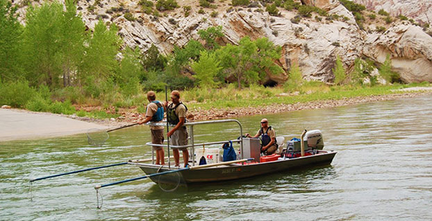
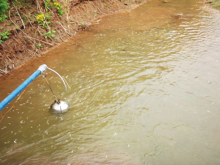
A Utah DWR field crew rides along in an electrofishing boat.
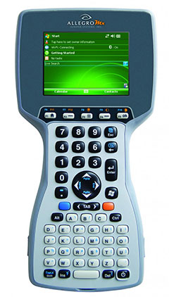
The Utah Division of Wildlife Resources (DWR) is using rugged Juniper Systems handhelds in an innovative way: to remove an invasive fish species from the Green River so that native fish can flourish.
A DWR field crew first used the Allegro MX handheld, loaded with custom fisheries software, to monitor native fish species and remove invasive fish in a 2013 project along the Green River, located near Dinosaur National Monument in Utah’s northeast corner.
The field crew’s work involved boat electrofishing, in which the researchers ride along in a boat with electrodes protruding into the water. The electrodes send out an electrical current, temporarily stunning the fish.The fish float to the surface, where they are netted and inspected.
Invasive fish are collected and removed from the river. Invasive species can degrade fisheries habitats and harm the ecosystem. Right, the Allegro MX handheld.
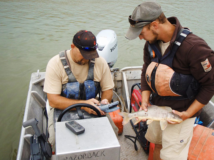
Every five miles, the crew stopped the boat and collected data on the fish. In a single day on a 12-mile stretch of the Green River, the crew caught 2,800 fish.
When a native species was caught, the fish was given a passive integrated transponder tag. Data was collected about the fish, and then it was released. When an invasive species was netted, however, it was kept for later data collection, and then removed from the river. Invasive species — fish transplanted from another location — can outcompete native fish, degrade fisheries habitats, and harm the ecosystem.
With high-value native fish, the team took a GPS point and collected data on the species, length, weight, sex, ripeness, and more, explained Juniper Systems’ natural resources market manager Trevor Brown, who accompanied a crew.
Brown explained that understanding the location of native fish helps fisheries biologists determine the effectiveness of previous removal efforts: Are native fish prospering in areas where invasive species were previously removed? Location also helps biologists associate where native fish are caught with habitat characteristics, which helps guide more targeted invasive removal efforts.
Allegro MX handheld.
Because the Green River is a a major tributary of the Colorado River, the boat crews submit their data to a central database that supports a larger effort to understand the status and health of fisheries systems of the entire Colorado River watershed. The information is used to guide management and policy decisions, fish regulations, and fisheries research.
“Location-specific data can help biologists understand population and dispersal of both native and non-native fish at a macro level,” Brown said.
The Utah DWR made the switch to the Allegro MX after seeing its benefits, including its full alpha-numeric keyboard, which allowed for rapid, accurate data entry, as well as its extreme ruggedness, sunlight-readable display, integrated GPS, and RFID compatibility.
The team even found the Allegro MX, rated IP67, could float — an additional bonus when working along a river in a shallow craft.
Brown customized the fisheries software for the Utah DWR field crews. The crews previously collected data using pen and paper, and then manually entering it into Microsoft Excel, a time-consuming and error-prone process. The custom fisheries software, available through Juniper Systems, reflects the data that needs to be collected, with required data fields and streamlined data entry. Because many of the Utah DWR crews are made up of seasonal workers, Brown designed the fisheries app to be easy to learn and use.
Biologists use the Allegro MX to collect data on the fish, including this endangered razorback sucker.
Northern Pike. Besides boat electrofishing, the fisheries software can be used for other applications, including an invasive fish removal application called fyke netting. Shaped like a bag with several hoops forming its structure, a fyke net acts as a funnel to trap swimming fish. The Utah DWR uses fyke nets primarily in the spring to trap invasive northern pike while they are spawning. After setting the fyke nets, crews return to check them and collect data on the trapped pike.
The fisheries software is also used for tributary electrofishing data collection, in which wader-clad crews walk along tributaries with electrofishing backpacks, shocking the water. As in boat electrofishing, the crews collect the invasive fish for later data collection, and they tag and collect data on native fish before releasing them.
The team experienced significant improvement with the new data collection process. “[The fisheries software] greatly reduced the data-entry time to the point where it has already paid for itself,” said Joe Skorupski, Native Aquatics Biologist at the Utah DWR. “Last year with three people, we took over 200 hours to enter, verify, and manipulate data. This year, it took one person 20 hours and errors were nonexistent due to the software and new data-collection process. I could go on and on about all the great improvements due to the handheld and the software.”
Since 2013, the Utah DWR has expanded its use of the Allegro MX and software for parallel projects, such as native fish sampling on fast-moving sections (Flaming Gorge) of the Green River, where fewer invasive fish are present.
March 2014 US Topo map of the Moab, Utah area, 1:24,000 scale. Orthoimage layer is turned on, contour and woodland layers turned off. Map: USGS
Newly released US Topo maps for Utah now feature a new commercial road data provider. The latest highway, road and street data from HERE has been added to the 1,476 revised US Topo quadrangles for the state.
“HERE, a Nokia business, is proud to provide fresh, robust and comprehensive map content to the State of Utah and the US Topo Maps program,” said Roy Kolstad, VP Sales Enterprise Americas, HERE. “We are excited for users to experience the benefits HERE brings with our more than 25 years of experience in cartography, drawing on more than 80,000 sources of data.”
The new maps also include Public Land Survey System (PLSS). These data are added to the growing list of states west of the Mississippi River. PLSS is a way of subdividing and describing land in the United States. All lands in the public domain are subject to subdivision by this rectangular system of surveys, which is regulated by the U.S. Department of the Interior. Other selected states will begin getting PLSS map data during the next respective revision cycle.
The new design for US Topo maps improves readability of maps for online and printed use, while retaining the look and feel of the traditional USGS topographic map. Map symbols are easy to read when the digital aerial photograph layer imagery is turned on.
Other re-design enhancements and new features:
New shaded relief layer for enhanced view of the terrain
Military installation boundaries, post offices and cemeteries
New road classification
A slight screening (transparency) has been applied to some features to enhance visibility of multiple competing layers
New PDF legend attachment
Metadata formatted to support multiple browsers
1885 historical USGS map of the Moab, Utah area, 1:250,000 scale. Map: USGS
US Topo maps are created from geographic datasets in The National Map, and deliver visible content such as high-resolution aerial photography, which was not available on older paper-based topographic maps. The new US Topo maps provide modern technical advantages that support wider and faster public distribution and on-screen geographic analysis tools for users.
The new digital topographic maps are PDF documents with geospatial extensions (GeoPDF) image software format and may be viewed using Adobe Reader, available as a no-cost download.
US Topo maps are updated every three years. The initial round of the 48 conterminous state coverage was completed in September of 2012. Hawaii and Puerto Rico maps have recently been added. More than 400 new US Topo maps for Alaska have been added to the USGS Map Locator & Downloader, but will take several years to complete the vast state.

 A report issued by the