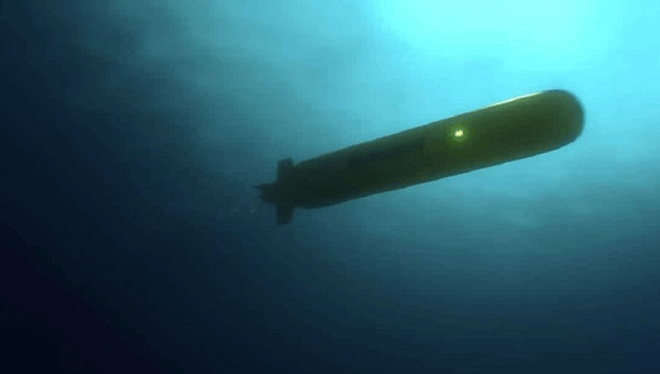
Exail has signed a contract to supply 100 Phins compact inertial navigation systems (INS) to a U.S.-based global defense company for use in unmanned underwater vehicles (UUVs). The Phins Compact INS is designed to provide precise navigation capabilities in challenging environments, remaining functional even when external signals are disrupted. The system’s compact design enables rapid integration into UUVs, allowing for flexible and efficient mission operations in dynamic maritime settings.
According to the company, this contract strengthens Exail’s global leadership in subsea navigation, with its INS technology trusted by more than 50 navies and widely deployed on a broad range of subsea autonomous vehicles worldwide. It also represents a key milestone in the company’s expanding presence in the United States, supporting defense programs with proven, high-performance solutions.
A new case study focuses on improving the endurance and navigational precision of underwater autonomous systems.
Sonardyne, designer and manufacturer of underwater positioning and inertial navigation, describes the challenges to increase navigation capability for subsea monitoring and inspections. Sonardyne joined the National Oceanography Centre (NOC) and L3Harris ASV on a two-year project to develop new positioning technologies to extend the limits of AUVs and UUVs.
The project — Precise Positioning for Persistent AUVs (P3AUV) — is supported with £1.4 million in funding through Innovate UK’s research and development competition for robotics and artificial intelligence in extreme and challenging environments.
Sending autonomous and unmanned underwater vehicles (AUV, also known as UUVs) out on missions that will last for days or weeks, unaided by vessels or other supporting offshore infrastructure, is a major goal for the ocean science, offshore energy and defense sectors.
Photo: Sonardyne
Sustained Ocean Observation. The research community aims for sustained ocean observation without the need for ship support, especially in ice-covered polar areas. Long-duration navigational capability is also a key enabler for persistent covert surveillance operations in the defence sector. And emerging applications include resident seabed-based systems, deep-sea mining, aquaculture and UXO surveys for renewable installations.
Autonomous AUVs would remove the need for a surface vessel, reduce risk to personnel, and reduce costs. Users could survey more seabed for longer and with fewer or even no people offshore.
The team is developing ways to provide greater positioning accuracy for long-endurance operations in deep water, while also reducing power requirements. The team will also be increasing the use of autonomy to make long baseline (LBL) positioning transponder box-in faster and easier, with onboard data processing and calibration.
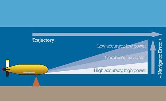
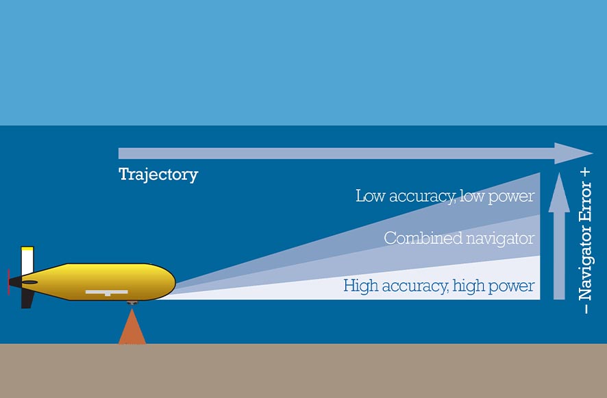
High-power INS input. Central to this work is the AUV’s acoustic and inertial navigation system (INS). Low-power sensors have much lower navigation accuracy and often have to surface to correct positioning error with a GPS fix. The team seeks to integrate low- and high-power sensors to achieve high performance at much lower power consumption.
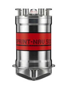
For instance, the NOC’s Autosub Long Range (ALR) uses a low-power microelectronic mechanical system (MEMS) supported by separate Doppler velocity log (DVL) and ADCP input to calculate how far it has traveled on missions, which can be several months long. To increase the ALR’s positioning accuracy over longer distances, the team is using the Sonardyne SPRINT-Nav all-in-one subsea navigation instrument alongside MEMS technology to work towards high-precision solutions that save space and power.
Image: Sonardyne
Accuracy during ascent and descent. The project also involves improving positioning accuracy when subsea vehicles transition through the water column. This is a notoriously difficult area for AUV deployments, because it relies on the Doppler velocity log (DVL) being able to lock on to the seafloor (bottom lock), so that vehicle XYZ velocities can be calculated, supported by pressure data.
However, DVLs are range limited, so there is often a period where the DVL is out of range. When there are thousands of meters of water between the surface and the seabed, this can introduce significant positioning uncertainty.
By using the acoustic Doppler current profiler (ADCP) capability in Sonardyne’s SPRINT-Nav INS instrument (looking down) and a second Syrinx DVL (looking up), the team could then build up a layer-by-layer profile of the water column velocities to be used as tracking layers.
The objective is to reduce positioning errors significantly during both the dive and surfacing phases of an operation. Results depend on the variability of the current in any given area.
The data collected during the descent and surfacing phases can be processed to provide a full ocean-depth current profile — collection of which is required for many offshore energy projects and can be valuable for ocean research.
A surrogate LDUUV is submerged in preparation for a test to demonstrate the capability of the Navy’s Common Control System at the Naval Undersea Warfare Center Keyport in Puget Sound, Washington. (U.S. Navy photo)
The U.S. Navy tested its newly developed Common Control System (CCS) with a submersible unmanned vehicle during a series of underwater missions at the Naval Undersea Warfare Center Keyport in Puget Sound, Washington.
The CCS successfully demonstrated its capability to provide command and control to a surrogate Large Displacement Unmanned Undersea Vehicle (LDUUV).
CCS is a software architecture with a common framework, user interface and components that can be integrated on a variety of unmanned systems. It will provide common vehicle management, mission planning and mission management capabilities for the Naval unmanned systems portfolio.
During the test events in Dec. 7-11, operators from Submarine Development Squadron 5 Detachment UUV used CCS to plan and execute several surveillance and intelligence preparation missions. The CCS sent pre-planned missions — via radio link — to the LDUUV’s autonomous controller and displayed actual vehicle status information to operators during the test. The vehicle was able to maneuver to the target areas and collect imagery.
“These tests proved that operators could use CCS from a single global operations center to plan, command and monitor UUVs on missions located anywhere in the world,” said Capt. Ralph Lee, who oversees the Navy’s CCS program at Patuxent River, Maryland. “This event also showed us that CCS is adaptable from the UAV (unmanned aerial vehicle) to UUV missions.”
Teams from the Navy’s Strike Planning and Execution and Unmanned Maritime Systems program office (PMA-281), Naval Air Warfare Center Weapons Division, Space and Naval Warfare Systems Command Pacific, John Hopkins and Penn State universities worked together to design, develop and test the software before executing the live demonstration in December.
“We had a really talented group of people working on this project,” said Vern Brown, who supports the CCS Advanced Development team based in China Lake. “It was exciting taking the CCS concept of controlling an undersea vehicle from inception early in the year to a successful in-water demonstration.”
CCS is intended to be compatible across all domains — air, surface, undersea and ground. The Navy initially plans to deploy the CCS on unmanned air vehicles. It will provide common vehicle management, mission planning and mission management capabilities for the Naval unmanned systems portfolio.
“Ultimately, CCS will eliminate redundant efforts, encourage innovation and improve cost control for unmanned systems,” Lee said.
Personnel supporting the Navy’s CCS program review data during a test event in December 2015 at the Naval Undersea Warfare Center Keyport in Puget Sound, Wash. (U.S. Navy photo)
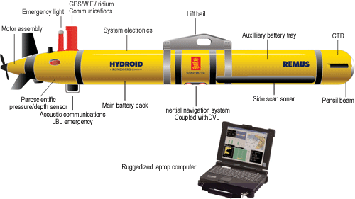
The Remus 600 Unmanned Underwater Vehicle, made by Kongsberg Maritime, a Norwegian company.
The U.S. Navy plans to deploy its first underwater drones from submarines later this year, according to a report by Military.com.
The website quoted Rear Adm. Joseph Tofalo, the Navy’s director of undersea warfare, who said the deployment will include the use of the Remus 600 Unmanned Underwater Vehicles (UUVs) to perform undersea missions around the globe.
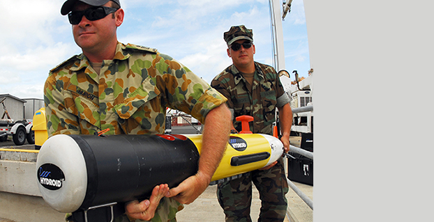
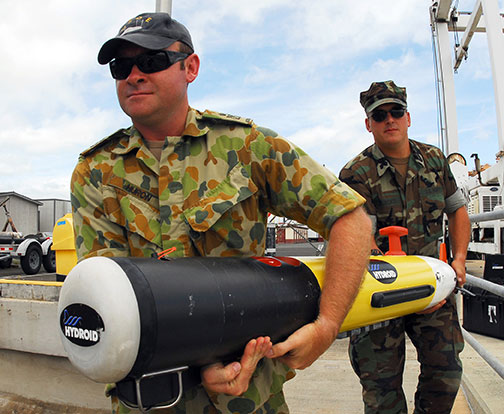
Sailors carry a Remote Environmental Measuring Unit (REMUS) 100. (Credit: U.S. Navy)
“Now you are talking about a submarine CO who can essentially be in two places at the same time — with a UUV out deployed which can do dull, dirty and dangerous type missions. This allows the submarine to be doing something else at the same time,” Tofalo said. “UUVs can help us better meet our combatant command demand signal. Right now, we only meet about two-thirds of our combatant commanders’ demand signals, and having unmanned systems is a huge force multiplier.”
The Remus 600 is a 500-pound, 3.25-meter-long UUV equipped with GPS, as well as dual-frequency side-scanning sonar technology, synthetic aperture sonar, acoustic imaging, and video cameras manufactured by Hyrdoid, a subsidiary of Kongsberg Maritime. The Remus 600 is similar to Bluefin Robotics UUVs, which were used to search for wreckage of missing Malaysia Airlines flight MH370. Other applications include hydrographic surveys, harbor security, and environmental monitoring.
In this video, Explosive Ordnance Disposal Mobile Unit One (EODMU-1) tests the Remus 600 to locate mines using autonomous guidance and advanced sonar.