Tag: Viametris

  • Viametris launches new version of urban and road scanner

    Photo: Viametris
    Photo: Viametris

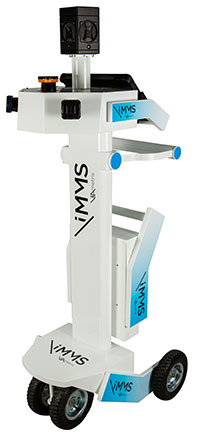
    Viametris has launched the second-generation version of the vMS3D, its urban and road lidar scanner.

    The second-generation version of the 3D mobile vehicle scanner has been redesigned to be more compact. The system has been simplified considerably in both electronic and ergonomic terms to make it more robust and stable in adverse conditions and challenging environments.

    Despite being lighter, the second generation offers the same technological capacities as its predecessor, but is simpler to use and can be mounted on a vehicle in minutes.

    The system component (including the sensors) and the element to affix the device to the vehicle (the frame) previously formed one unit, but are now separated.

    • The redesigned system is much lighter (9 kg) and more compact.
    • The mechanism to fix the scanner to the vehicle, which formed part of the system in the first-generation version, has been transformed. A rigid metal frame, fixed onto two roof bars, now holds the system, which fits into a dedicated compartment in seconds. As the frame is rigid, it limits vibrations between the system and the vehicle and prevents any strain on the mechanics during acquisition.
    • The second auxiliary antenna, which measures the heading by satellite, is discreet and non-removable, and fixed directly to the vehicle chassis.

    The new design makes it easier to mount and use the system, a task that can be accomplished by a single person in under three minutes. Alignment takes place the first time the system is mounted and does not need to be repeated, saving valuable time each start.

    Technological features

    The vMS3D comprises a new set of components that are more robust and stable in difficult conditions.

    • The integrated connectors are next-generation and embedded-grade.
    • The control box for power supply and communication with the tablet has been moved inside the vehicle to offer increased comfort to the user.

    Specifications

    Receiver: Septentrio AsteRx-m2a GPS+GLONASS+BeiDou+Galileo, 448 channels – L1/L2, B1/B2, E1/E5B, RAW

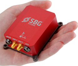
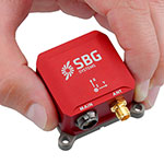
    IMU: SBG-Systems Ellipse2-D

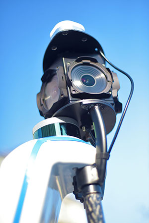
    Scanner: 700,000 points per second

    Centimeter precision

    Panoramic 30MP FLIR Ladybug 5+ camera

    Double antenna

    SLAM compatible

  • New Viametris backpack scanner integrates SBG Systems product

    Viametris, specialist of SLAM-based mobile scanning systems, has launched a backpack-based scanning system called the bMS3D-360. The company continues to rely on SBG Systems’ expertise in inertial navigation by integrating the Ellipse2-D, an inertial navigation system with embedded real-time kinematic (RTK) GNSS receiver.

    Photo: Viametris
    Photo: Viametris

    Viametris has been developing SLAM-based scanning systems for more than 10 years, including the iMS3D, a full indoor mapping system and the VMS3D, a car-based mapping system.

    The bMS3D-360 has been designed for the most challenging environments where GNSS is not accessible (indoor) or highly perturbed (urban canyons, forest, etc.). The surveyor starts the system, checks on a tablet that the GNSS and inertial information are computed, and starts the survey.

    Back at the office, the user launches the INS/GNSS post-processing software to increase orientation and position accuracy, and then uses the Viametris software to georeference and colorize the point cloud.

    Collected data are ready to be imported into common design software. This workflow (from collection to plan drawing) is seven times faster than a traditional method.

    The bMS3D-360 offers a 360-degree camera, which greatly simplifies the treatment work. When navigating in the point cloud, the user opens a unique picture of the 360-degree scanned environment instead of looking at four different camera points of view.

    Photo: SBG Systems
    Photo: SBG Systems

    The Ellipse2-D from SBG Systems is a compact inertial navigation system integrating an L1/L2 GNSS receiver. This industrial-grade INS computes roll, pitch and heading as well as position because of its embedded Extended Kalman Filtering.

    In real time, Ellipse2-D orientation data are used to correct the equipment attitude and help the SLAM computed heading. The embedded GNSS receiver provides absolute positioning to the point cloud as well as altitude constraint.

    When the GNSS faces sources of disturbance, the INS maintains the trajectory were the SLAM technology is limited.

  • Viametris mobile backpack scanner includes panoramic camera

    Mobile-scanning company Viametris has launched the bMS3D backpack mobile scanning system, which features an embedded 360° camera.

    Narrow streets and pedestrian zones are considered hurdles when it comes to mobile scanning. The new bMS3D-360 makes these tasks achievable. It is now available on the market and it comes with post-processing software. It will be presented at SPAR 3D 2018 in June.

    “Users of mobile scanning systems know how difficult it is to cover an entire city with this kind of system and how complex the completeness is,” said Jerome Ninot, founder of Viametris.

    Improved Data Exploitation with Panoramic Images. Viametris has found a solution to scanning challenges by developing the bMS3D-360: the mobile scanning backpack system includes a panoramic camera. This sensor allows the user to maintain continuity of results with mobile mapping systems on cars that already include this kind of camera. Operation and visualization with such 360° images are now easy to use.

    Since Google provided massive street views, people are used to navigating through panoramic images. Navigating through bMS3D-360 images becomes easy and intuitive compared to navigating with 3D point clouds, the company said.

    Ten years of experience have allowed Viametris to produce its GNSS mono-antenna system based on GNSS-free scanning (indoor or denied-GNSS area): the system trajectory is calculated by lidar-SLAM. It produces colorized point clouds with absolute accuracy of less than 5 centimeters under appropriate satellite reception conditions.

    Compared to many mobile scanners, this backpack does not rely on GNSS to work. If the GNSS reception is not good enough, control points can be added for absolute localization. The backpack can be used to scan all sorts of indoor areas such as airports, industrial buildings or shopping malls.

    The bMS3D-360 is lightweight. It protects the retractable camera an all other components since it is self-contained.

    Post process in VIAMETRIS PPiMMS Software. PPiMMS post-processing software manages the dataset coming from the system. Its mission is to calculate, control and improve the trajectories by calling lidar-SLAM functions, and reducing drifts, thanks to loop closure algorithms.

    The user can manually add GCPs to constrain the result when GNSS reception is poor. But, in most cases, the user will be able to include post-processed global positions (PPK) using GNSS post-processing software. Additionally, the panoramic camera can be used to colorize the point cloud using PPiMMS.

  • SBG, Viametris Present 3D Indoor Scanning System at INTERGEO

    SBG, Viametris Present 3D Indoor Scanning System at INTERGEO

    The iMS 3D indoor mapping system by Viametris uses an Ellipse-A by SBG for roll and pitch data.
    The iMS 3D indoor mapping system by Viametris uses an Ellipse-A by SBG for roll and pitch data.

    SBG Systems will join Viametris in presenting a new 3D indoor scanning system at the INTERGEO trade show, which will be held Sept. 15-17 in Stuttgart, Germany.

    The iMS 3D is a mobile 3D indoor scanner generating continuous point clouds. For this brand-new model of indoor mobile mapping system, or iMMS, Viametris chose SBG Systems’ miniature Attitude and Heading Reference Sensor (AHRS), the Ellipse-A. The iMS 3D is easier to transport, install and set up than previous iMMS. The iMS 3D also integrates new sensors, including the Ellipse-A from SBG Systems.

    Based on the SLAM technology, the iMS 3D is equipped with three lidar profilers, each taking 40,000 points per second. The main lidar provides the horizontal profile, which also contributes to the continuous calculation of the iMS 3D position in the building. Two lateral lidars give vertical profiles, including the ceiling. While the user walks, pushing the iMS 3D at normal speed, the 3D profile of the room appears on the screen, since the system records 3D measurements of the same room. Easy to manipulate, one person is enough to survey every corner of the building with the iMS 3D.

    During the survey, the 360-degree camera takes a spherical picture every two meters for a full documentation of the building. This solution makes indoor survey 10 times quicker than traditional methods usually using distance meters, Viametris said, adding that the iMS 3D delivers a combination of point density, acquisition speed and accuracy suitable for the building trade industry.

    At the office, the user accesses a centimeter-level accuracy 3D survey as a point cloud and pictures by using the Viametris processing and browsing software. The user can import the point cloud in CAD software (Autodesk Revit, AutoCAD, MicroStation, Rhino, etc.) to easily produce 2D maps or 3D models. The point cloud can be colorized with the colors of the pictures taken during the survey, which greatly improves the environment understanding. Additionally, the user has access to contextual 360-degree pictures, making objects such as radiators, extinguishers or lights simple to distinguish and locate.

    Ellipse-A.
    Ellipse-A.

    Already integrated in other Viametris ultraportable technologies, the Ellipse-A has been chosen for this new generation of indoor mobile mapping system, or iMMS. “We integrated an Ellipse-A in our 2D system and were very happy with the results. It was obvious to us that the Ellipse-A will be part of our new iMMS,” said Jérôme Ninot, president of Viametris. The Ellipse-A is used to correct the horizontal profile. While the user is pushing the iMS 3D through the rooms, unevenness, slopes and ramps, cables or door thresholds can cause noise in the point cloud. The Ellipse-A keeps the point cloud clean by correcting the horizontal lidar data frames used to build the trajectory.

    The Ellipse-A AHRS provides roll and pitch data accurate to 0.2° at 200 Hz. “The Ellipse sensors are much more efficient than the previous IG-500 product line,” said Mr. Ninot.

    Keeping lidar and camera data precisely synchronized can be difficult because the camera focal time is susceptible to vary. In mobile scanning, even a slight latency might cause an offset. For example, the picture will not be located on the right place inside the point cloud. Viametris decided to connect the camera and the three lidars to the Ellipse-A to ensure a highly accurate and repeatable synchronization.

    At INTERGEO 2015, the iMS 3D will be presented at stand # B4.049 and the ELLIPSE-A will be presented at stand # G4.079.