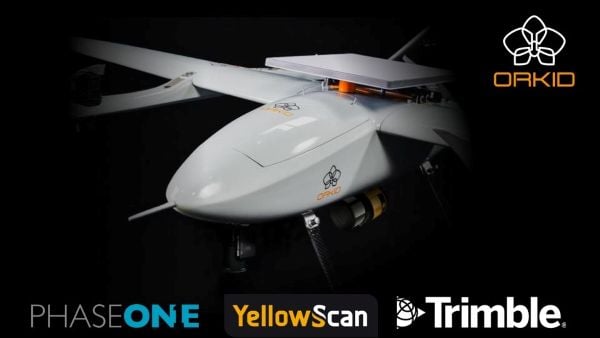
Drone-maker Orkid has unveiled a new variant of its Orkid 260 drone that incorporates four technologies to improve aerial data-capture technology.
According to the company, the Orkid 260VTOL represents a leap forward in the integration of advanced sensing and communication technologies, setting a new benchmark for multi-mission drone capability across commercial and industrial applications. The company said it is the “first vertical take-off and landing (VTOL) drone to bring all four of the most advanced aerial data capture technologies together — onboard, fully integrated, and operating simultaneously.”
The system combines lidar (YellowScan Surveyor Ultra), photogrammetry (Phase One P5 camera), GNSS/IMU (Trimble Applanix APX-RTX), and Starlink satellite communications integration in a single platform.
Built on a 100% electric, NDAA-compliant architecture, the aircraft delivers an estimated 1.5 hours of flight endurance with a range of up to 75 miles. Designed for mapping, surveying, utilities, oil and gas, defense, and critical infrastructure inspection, the new model expands the operational scope for high-precision, long-range missions.
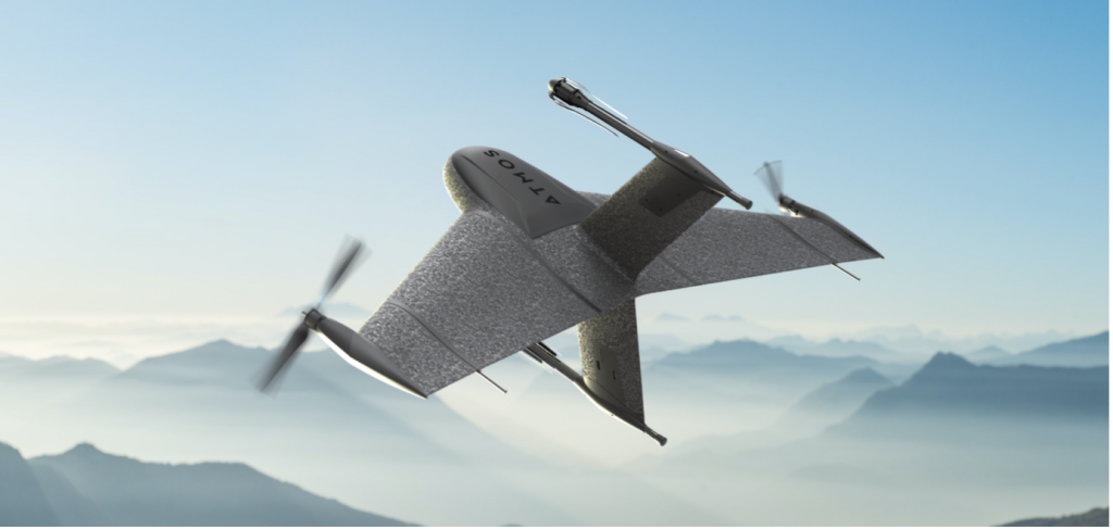
Atmos, a Dutch UAV manufacturer that develops high-end VTOL fixed-wing UAVs for mapping and surveying applications, expanded its global reseller network by signing a reseller agreement with Volatus Aerospace, a leader in commercial drones and UAV technology, in Canada.
Volatus will be responsible for the distribution of Marlyn Cobalt UAVs in Canada and will provide assistance and maintenance services to local UAV operators. The company brings extensive experience in aviation operations, safety, compliance and innovation to the evolving uncrewed aircraft market.
Marlyn Cobalt is the first fully autonomous hybrid (VTOL and fixed-wing) drone for mapping and surveying applications. With its patented design that combines the best of both worlds, Marlyn can take off vertically from anywhere and map fast and efficiently producing high-quality outputs for professional users. It is the only drone in its class that is built to perform even in harsh and windy conditions, while its easily swappable payloads provide operators with flexibility.
“We have an incredible team pushing the envelope on the entire spectrum of UAV technology,” said Glen Lynch, CEO at Volatus Aerospace. “The Marlyn Cobalt survey drone is an exciting new addition to our product offerings.”
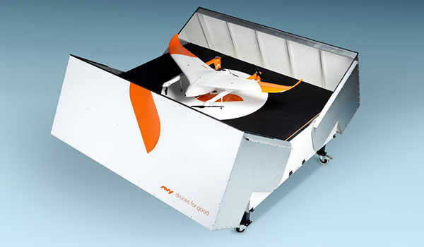
The Avy Aera departs from its docking station within minutes, shortening response times and reducing costs for first responders. (Photo: Avy)
Dutch company Avy has launched its Drone Response Network, combining docking stations with autonomous aircraft that have vertical take-off and landing (VTOL) capabilities.
The network offers drone coverage in a certain area, enabling instant deployment to support medical deliveries or emergency services during critical incidents.
First flights are expected to take place in the first quarter of 2022.
The network uses the Avy Aera autonomous drone that can carry up to 3 kg of medical goods over a distance of 100 km. It can operate year round, in rain and winds up to 45 kph, and is designed to meet the latest European Union drone regulations and United Nation requirements for aerial transport of medical goods.
For medical delivery, the drone is equipped with Aera’s Medkit, which has a four-liter capacity and is fitted with sensors for immediate assessment. Medical products remain cooled at 2-6 degrees for at least 100 minutes in an ambient temperature of up to 40° C.
The Avy Drone Response network is suitable for both urban and rural areas, delivering medicines, blood products, vaccines and other medical applications safer and twice as fast as road transportation, and is more environmentally friendly. It is expected to make a substantial contribution to achieving the goal of connecting hospitals and laboratories by air by 2023.
The Avy Aera can also be integrated with a high zoom RGB and thermal camera system and used to quickly detect wildfires, spot people in distress at sea, monitor oil spills and assess the situation on the ground.
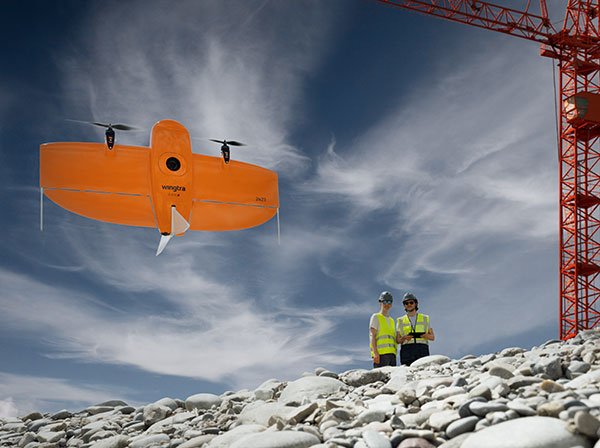
A new vertical-takeoff-and-landing (VTOL) drone — the WingtraOne GEN II — is now available. The GEN II offers industrial reliability and mapping versatility with an oblique camera configuration for high-quality 3D drone-mapping data capture.
Drone maker Wingtra spent six years developing the GEN II, and tested it over 100,000 flights. Its WingtraOne is being used by professionals worldwide across many industries.
According to Wingtra, the GEN II represents a solid step forward in industrialization and reliability along with new perks that push the previous limits of commercial mapping drones.
The WingtraOne GEN II. (Photo: Wingtra)
Oblique 3D Mapping Payload
“We wanted to make the WingtraOne drone even more versatile for our customers. So next to our flagship 42MP Sony RX1, we’re including new, high-end mapping payloads,” said Maximilian Boosfeld, co-founder and CEO of Wingtra. “I’m especially excited to announce our oblique solution, which offers outstanding 3D mapping results. It’s the perfect choice for capturing infrastructure — from a single industrial plant to entire cities.”
WingtraOne’s GEN II oblique mapping solution is backed by signed partnership agreements with Bentley Systems and Esri. To demonstrate the power of GEN II carrying its Oblique Sony A6100 payload, the Wingtra team mapped the city of Zurich, Switzerland, in six flight hours, producing a 3D model processed with both Bentley ContextCapture and Esri’s Site Scan for ArcGIS. Bentley and Esri’s software are both recommended for processing Wingtra oblique datasets.
“Bentley Systems is delighted to partner with Wingtra to transform high-resolution oblique imagery from WingtraOne drones into 3D reality meshes — an ideal starting point for infrastructure digital twins,” said Phil Christensen, VP, Industry Solutions, iTwin Context, Bentley Systems. “This enables our common users to perform analytics on the resulting models as well as leverage Bentley’s iTwin platform to share performant, city-scale digital twins.”
“Our partnership with Wingtra unlocks new capabilities for Site Scan for ArcGIS users by allowing them to create wide-scale and accurate 3D meshes leveraging the oblique payload on the WingtraOne Gen II,” said Richard Cooke, director of Global Business Development at Esri. “These high-resolution images processed through Site Scan produce an enriched 3D GIS for our users who require modelling of open-pit mines, accurate construction updates, creation of digital twins for cities, and more.”
The WingtraOne GEN II drone was used to map Zurich and create a digital twin of the city. (Image: Wingtra)
Integrated PPK and Self-Diagnosis
WingtraOne GEN II features post-processed kinematic (PPK) ability integrated on every drone, including multispectral Altum and RedEdge payloads, as well as advanced fail-safe and self-diagnosis algorithms and services for dependable operations.
“We have studied over 100,000 flights and all incoming customer reports to understand what the limits might be so we can push them further,” said Julian Surber, Wingtra product manager. “As a result, we’ve designed many reliability tools for GEN II to guarantee uninterrupted operations.”
Wingtra’s engineering team has redesigned the electronics of the GEN II from its predecessor WingtraOne for increased reliability, including a more powerful onboard computer, optimized PCB designs, and a new navigation and heading unit developed inhouse.
The GEN II runs through health-monitoring algorithms for motors, servos, batteries, camera, PPK and onboard sensors, health self checks that minimize the potential of flight with unsafe equipment.
Precision Agriculture Boost
Wingtra’s top-of-the-line multispectral payloads Micasense Altum and RedEdge will now be paired with high-accuracy PPK, which improves the quality of multispectral insights for uses such as irrigation management and prescription maps for pesticides.