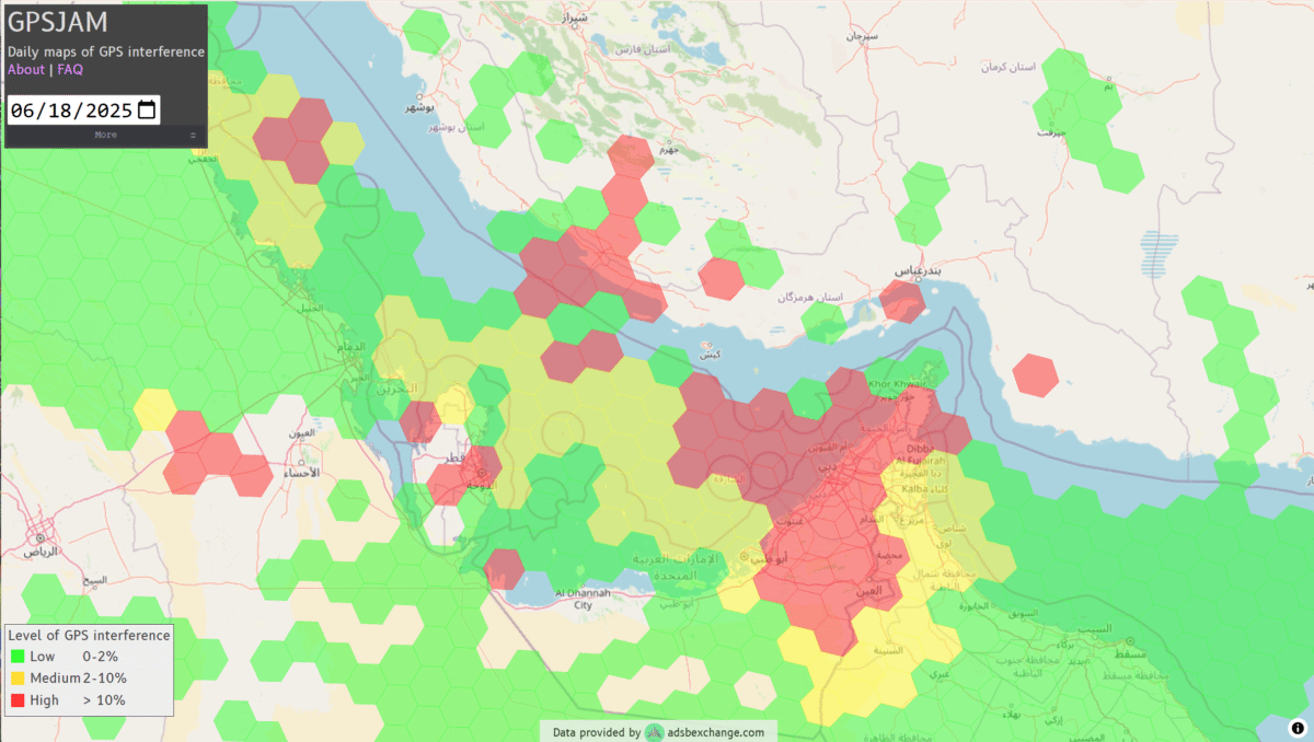
GNSS jamming is causing confusion for ships traveling through the Strait of Hormuz, reports gCaptain. The regional threat levels are labeled “significant” because of air strikes between Iran and Israel, according to the Joint Maritime Information Center (JMIC). Maritime threat levels are marked as “elevated”.
The JMIC highlighted GNSS jamming problems around the Port of Bandar Abbas and throughout the Strait of Hormuz and Persian Gulf regions. Nevertheless, commercial shipping traffic has continued at normal rates.
Naivgational error is considered the cause of a collision June 17 between two tankers in the Gulf of Oman. The Very Large Crude Carrier (VLCC) Front Eagle, with 2 million barrels of Iraqi crude bound for China, hit the Suezmax tanker Adalynn 15 nautical miles off Fujairah. There was fire on both ships, but no injuries. The Front Eagle appeared to be onshore in Iran days before the collision.
Nearly 1,000 ships in the Gulf have been affected by mass interference since the start of the Iran-Israel conflict on June 12, according to shipping analysis firm Windward. Recent tracking data has shown unusual positioning errors, with vessels appearing to be in impossible locations.
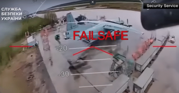
On June 1, 117 drones rose up from wooden boxes inside Russia and attacked bombers parked on runways at military bases. The attack — dubbed Operation Spider Web — startled the world with its audacity.
Approximately 41 planes were struck at four military bases, including the Belaya Air Base in Siberia hundreds of miles from Ukraine’s borders. In all, the attack destroyed a third of the bombers Russia uses as strategic cruise-missile carriers to destroy targets in Ukraine.
The drones were smuggled into Russia via commercial trucking transportation.
According to an analysis by Michael C. Horowitz for the Council on Foreign Relations, the strikes “once again demonstrated Ukraine’s ability to be at the cutting edge of technology and tactics. Ukraine has consistently and successfully leveraged and integrated everything from old military technology and off-the-shelf commercial systems to artificial intelligence (AI) for its military operations. This has been a difference maker in the war since its early days, giving Ukraine new and unexpected vectors to attack Russian forces and territory.”
The analysis, by Michael C. Horowitz, calls this a new era for warfare — the era of precise mass. “The combination of AI and autonomous weapons, precision guidance, and commercial manufacturing mean that low-cost precision strikes are now accessible to almost any state or militant group,” Horowitz writes.
The attack demonstrates that countries can be at risk to drone attacks even deep inside its borders, and precision strikes the capability of any actor. Low-cost off-the-shelf drones can be readily used, along with open-source autopilot software and AI code. Drones can supplement or even replace traditional artillery or expensive cruise missiles.
News from the U.S. Army Space and Missile Defense Command/Army Forces Strategic Command
The secretary of the United States Army has designated the U.S. Army Space and Missile Defense Command/Army Forces Strategic Command as the Army’s representative to identify and advocate for positioning, navigation and timing (PNT) information as well as establish and formalize joint navigation warfare, or NAVWAR, requirements.
“Navigation warfare is really about taking a look at different position, navigation, and timing signals and figuring out how the signals flow; the potential for adversaries to disrupt our ability to use them in the future; and how can we not only protect ourselves from the enemy denying us with those abilities, but also how can we do the same to our enemies and affect them and disrupt them in a multi-domain operational environment,” said Col. Timothy G. Dalton, USASMDC/ARSTRAT U.S. Army Training and Doctrine Command, or TRADOC, Capabilities Manager for Space and High Altitude, or TCM SHA.
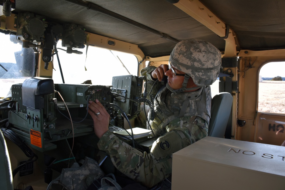
Soldiers in the field learn how to operate in a NAVWAR environment. (Photo: U.S. Army)
What NAVWAR Does. NAVWAR allows the Army to take deliberate defensive and offensive actions to assure U.S. forces PNT information through coordinated employment of space, cyberspace and electronic warfare operations. PNT data enables the Army to precisely move, shoot and communicate; extend its operational reach; control the tempo of operations; and perform mission command, all without adversarial interruption.
NAVWAR capabilities include electronic protection which includes systems and capabilities required to defend platforms and systems against electronic acts in the GNSS electromagnetic spectrum.
The Army has more than 250,000 GPS-dependent systems.
Additionally NAVWAR provides electronic support to sensors and software used to search for, intercept, identify, locate or localize, and report sources of intentional and unintentional radiated GNSS electromagnetic interference for mitigation and planning future operations.
NAVWAR can also provide electronic attack with capabilities to seize and sustain the initiative by actively degrading or denying the GNSS electromagnetic spectrum to adversaries in multi-domain operations.
The Army is dependent on the use of this data with a typical brigade combat team depending on more than 28 different systems and 600 total systems that leverage PNT. The Army has more than 250,000 GPS-dependent systems.
“As the Army goes forward in multi-domain operations, what we see the battlefield becoming is a contested environment,” Dalton said. “What that means is there are adversaries that will look to challenge the United States across all operational phases and domains. These enemies will have the capability to disrupt signals, like GPS, that can impact a wide range of military and civilian activities.
New NAVWAR Concept. SMDC is developing a TRADOC-sponsored Army NAVWAR concept that will be used to establish a baseline for how the Army will execute the NAVWAR fight.
The Army is highly dependent on the use of GPS-delivered PNT data. NAVWAR prevents the use of GPS by hostile forces while ensuring unimpeded use for U.S. forces and allies.
“In the command’s advocacy role we work with the joint and Army communities to examine what the Army needs to be able to accomplish the mission through navigational warfare,” Dalton said. “We work with a community of interest to determine the requirements that will build capability and reduce shortfalls in this mission area.
“This includes activities like updating doctrine, our organizational structure, ability to train the force, and ultimately determine if we need additional equipment, or holistic solutions to protect capabilities and disrupt the enemy on the navigation warfare side,” he added.
Training and Research. SMDC, in conjunction with U.S. Forces Command and the Joint Navigation Warfare Center, supports training events under degraded GPS conditions. The goal is to enable tactical formations to develop and train tactics, techniques and procedures that enable Army formations to work.
“We help develop and focus the capability requirements for the Army,” Dalton said. “But we are integrating with a larger community, led by the Assured Positioning, Navigation and Timing Cross-Functional Team that is focused on modernizing the Army in this mission area.”
SMDC is the Army lead for institutional unity of effort on NAVWAR with several research, development, test and evaluation and capability integration efforts working on the issue independent of one another.
“It is definitely an exciting time for NAVWAR,” Dalton said. “The Army, services and Department of Defense, as a whole, have started to embrace the importance of this mission area and understand the competitive advantage the U.S. and our partners can gain while denying the adversary the ability to conduct operations with respect to navigational warfare.”
Longing for the good old days when we mostly worried about nukes
Years ago, Navy colleague Commander Stephen Rose drew a lot of attention at the Naval War College with his essay entitled “The Coming Explosion of Silent Weapons.” The essay was awarded both the Colbert Memorial Award and the Joint Chiefs of Staff Writing Prize. I never thought that 27 years later his paper would seem so timely and highlight the critical need for the geospatial work being done by the NIH (National Institutes of Health), CDC (Centers for Disease Control), DTRA (Defense Threat Reduction Agency), U.S. Army and others.
In his paper, Commander Rose reviewed emerging warfare technologies including chemical warfare, biological warfare, gene splicing, nano technology, remotely piloted vehicles (RPVs) and more. He compared the complexity and expense of a country trying to develop a nuclear capability compared to the relative ease and low cost of developing chemical and biological weapons, which were sort of a “poor man’s nuke.”
Although, years later, the countries named in the paper have not changed significantly: Iran, Iraq, Syria and Libya. You can read the full paper at the Naval War College website.
Worrisome at the time, most of us took comfort in the built-in deterrence that was intrinsic with chemical and, more so, biological weapons. It was a genie that with a slight change of wind direction could hurt friendly troops as easily as enemy troops. Even more problematic, biological agents could affect not only friendly troops but even the user’s families in their own home towns. So for the past 27 years we’ve whistled past the graveyard in the belief that no one would be crazy enough to use biologics.
Although we were Cold War enemies, I knew that my Soviet counterparts shared most of my values. They enjoyed life, loved their families, relished their vodka and just wanted to go home and perhaps work on their Dachas. Even Star Trek Klingons were philosophically not that different from either of us. Enter the 21st century, and now suicide bombing has become a virtue with cash rewards paid to the surviving family members and a path to heavenly pleasures for the bomber. This, of course, changes everything.
Congressional testimony by National Intelligence Director Clapper and others have pointed to a growing concern about chemical and biological attacks. Additionally, some terrorists are not intellectual lightweights. Recently, the former Iraq chemical and biological expert Sleiman Daoud al Afari was captured, and this week the number two man in ISIS, former physics professor Haji Imam, was killed. So is it just a matter of time before someone with the right knowledge, skills and relatively light resources builds a biologic that gets out of control?
Esri Federal GIS Medical Special Interest Group
During the recent Esri Federal GIS Conference in D.C., I attended a session concerning GIS and global responses to pandemics and biological threats. The session was moderated by Dr. Este Geraghty, MD, MS, MPH, CPH, FACP, GISP, who is Esri’s chief medical officer.
Although the discussion focused mostly on the Zika virus, much of the background information covered the geospatial aspects of the Ebola outbreak in Africa. According to one of the presenters, David Foster, a U.S. contractor and prior Air Force veteran who participated in the response, the world response was quick, but it was also a dizzying collection of government and non-government agencies with more than 80 different responding groups. Somewhat disconcerting was that no one was really in charge and communications was poor.
Dr. Geraghty was kind enough to do a video interview, primarily focused on the concerns of this article and the need for a strong geospatial monitoring and analysis capability.
One example: Early GIS at CDC
In 199 when I retired from the Navy and became the GIS manager of the Atlanta Regional Commission, we established the region’s first Esri ArcView Learning Center. A number of CDC doctors and staff members took our ArcView II classes. Six months later, I was humbled with what those early students had accomplished. They used the relatively basic ArcView II to map disease outbreaks domestically and worldwide. The maps provided a valuable visualization tool that helped with understanding complex outbreaks and how to combat their spread.
The growing need for more sophisticated spatial monitoring, analysis and display led to the creation of GRASP (Geospatial Research, Analysis and Services Program). CDC and the Agency for Toxic Substances and Disease Registry, Division of Toxicology and Human Health Sciences (ATSDR/DTHHS) worked to build the needed geospatial capability, and in 2013 Booz Allen Hamilton was awarded a competitive contract to build a unified and comprehensive GIS support system for CDC and ATSDR.
GRASP program specifics include:
GIS analysis, research and geospatial statistics.
GIS remote sensing imagery analysis.
Cartographic design and production.
GIS web/desktop/mobile application design, development and maintenance.
GIS shared service design, development and maintenance.
GIS database design, development, management and maintenance.
GPS data-gathering, training and support.
GIS systems integration.
GIS training.
GIS project management.
GRASP has grown into a sophisticated monitoring and analysis system. When a serious outbreak occurs, CDC responds like other emergency response organizations and stands up an Emergency Operations Center (EOC) in accordance with the National Incident Management System (NIMS). GRASP maps, imagery and visualizations help everyone understand the nature and scope of the threat by creating a common operational picture.
This capability is further enhanced with new Esri tools such as Insight, easy geocoding, big-data deep analysis, tools for activating response teams, as well as sharing and collaboration with other federal agency and resources such as GEOINT, HUMINT (human intelligence), SIGINT (signals intelligence) and social media.
Natural or man-caused, and who makes the call?
Getting back to Commander Rose’s paper, one is left with the following points to ponder. Following a conventional or nuclear attack, a country instantly knows three things: that it’s been attacked, when it was attacked and where it was attacked. As a result, the subject country stands a good chance of figuring out who did the attack.
Conversely, with a biological attack, a country may not know when or where the attack occurred, or if it was even an attack and not just a natural outbreak. This then becomes a tough decision for our analysts, because announcing a devastating outbreak as a biological attack could be tantamount to announcing a modern-day Pearl Harbor without the benefit of seeing burning ships or falling buildings. Additionally, the path from analysis to a definitive determination and by who may not be completely clear.
Existential threat?
So, are we in a Cornelian dilemma? Are we better off pulling back and lying low in hopes that “they” won’t hate us enough to initiate a suicidal attack that launches Armageddon? Or do we act preemptively with all our intelligence and military resources to beat down any group that shows the slightest inclination and potential to entertain this suicidal activity?
Some politicians have stated that although we lost more than 3,000 people during 9/11, it was a relatively small percentage loss in the grand scheme of things; that the U.S. is so big and so powerful that we don’t face an “existential threat.” So one would have to ask if the loss of 10, 20 or 50 percent of our population would be existential enough?
Complicating the issue, as some of my intel colleagues are fond of pointing out, is that if some actions we are currently taking or not taking seem to make no sense, it’s probably because you don’t know all the facts.
Regardless, our monitoring and analysis capability may be one of the most important activities being done by our geospatial community. Additionally, we need to make sure that our protective agencies get what they need to do the monitoring and analysis to keep us safe. My hope is that we really are doing what needs to be done and not just dreaming of the good ol’ days when all we had to worry about was a nuclear attack.