TRX Systems has added a jammer finder capability to its NEON PT-MIL. The new function and expanded threat-mapping features enable dismounted soldiers to proactively respond to navigational warfare attacks (NAVWAR).
NEON PT-MIL helps warfighters carry out their missions even when operating in environments where GPS/GNSS signals are unreliable or intentionally denied. The device can detect and eliminate compromised GNSS data while providing an alternative source of positioning information by fusing inputs from inertial sensors, GNSS signals, ultra-wideband and more.
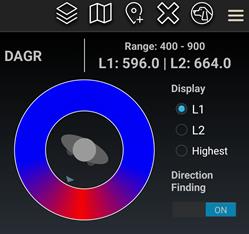
NEON PT-MIL can also be equipped to detect and map jamming and spoofing attacks. This feature was developed through a United States Army Rapid Capabilities and Critical Technologies Office program designed to extend NAVWAR functionality. The device accepts assured GNSS data from external devices — such as the Defense Advanced GPS Receiver, or DAGR, and the Orolia Defense and Security Broadsense Nano — to deliver a fused position and a NAVWAR threat indication when detected.
The device can also derive a line of bearing to an enemy jammer and display it within the warfighter’s Android Tactical Assault Kit (ATAK) user interface, by using the GPS jamming indications available from a connected GNSS source.
NEON PT-MIL with the jammer finding function is available in beta versions for field testing now and will be generally available in mid-2023.
What works well and what needs improvement in the GPS program regarding technology, policy, or management?
Jules McNeff
“GPS technology and operational performance continue to set the standard for GNSS, but necessary modernization is late to need, and becoming later by the day. This reflects what I see as loss of focus on ‘Job 1’ (delivering effective GPS service to the Joint Force) and a diminution in the sense of ‘GPS uniqueness and exceptionalism’ in its management as it was fragmented within the old SMC and is no longer the ‘shiny new object’ within the evolving Space Force. Even so, its value to its global user base, and particularly to U.S. and allied militaries, is stronger than ever and it remains the cornerstone among diverse complements within the Department of Defense PNT Enterprise. It is incumbent on the DOD to ensure the GPS services our warfighters will depend on can sustain that vital role.”
— Jules McNeff Overlook Systems Technologies
Ellen Hall
“What works well? There is good focus on the areas that need development: M-code, CRPA, resiliency. What needs improvement? More thorough and timely sharing of information by the government with industry.” — Ellen Hall, Spirent Federal Systems
Mitch Narins
“The ‘GPS program’ has set the standard for all other GNSS efforts, but there are always lessons to be learned. I have full confidence that USSF leadership is well equipped to deal with both the technology and management aspects of the program. As for policy, which supports military and civil uses worldwide, there is a clear distinction, based on mission areas and acceptable risk. However, risks to civil users have increased as GPS PNT services permeate all civil critical infrastructure systems. Therefore, system improvements directed at civil user PNT resilience should be given a higher priority and funded through appropriate civil channels. I encourage a policy to enable more resilient PNT services from space — and to consider that by looking both ‘up’ and ‘down’ for PNT services, unfortunate ‘situations’ might be avoided.” — Mitch Narins,
Strategic Synergies
Bernard Gruber
“One of the most consistent and enduring enablers of the GPS program is national policy. NSPD-39 re-baselined requirements buttressed by GPS being provided to the world for free, that it must be sustained and have an ever-present focus on performance improvement and robustness. Accordingly, NSPD-7 acknowledges an ever-changing world with a nod to cybersecurity, augmentations and direction to “improve NAVWAR capabilities to deny hostile use of United States Government space-based PNT services, without unduly disrupting civil and commercial access to civil PNT services.” — Bernard Gruber,
Northrop Grumman
New M-code GPS receiver enables precision strike capabilities in contested environments
Image: BAE Systems
BAE Systems unveiled its newest advanced M-Code GPS receiver for guided weapons and other small applications at the ION Joint Navigation Conference, taking place this week in San Diego.
The Strategic Anti-jam Beamforming Receiver – M-Code (SABR-M) enables precise geolocation and strike capabilities in highly contested battlespaces. It delivers accurate position, velocity, altitude and timing data, as well as strong protection against GPS signal jamming and spoofing – critical capabilities for unmanned aerial vehicles (UAVs), precision-guided munitions (PGMs), and missiles in threat environments.
SABR-M integrates receiver technology with advanced antenna electronics in a small, hardened package designed to meet challenging performance requirements, such as weapons applications. It is the most capable integrated anti-jam GPS receiver and the first integrated M-Code receiver available for weapon systems, according to BAE Systems.
“We’re making our full portfolio of military GPS solutions M-code-compatible to meet warfighters’ need for reliable positioning, navigation, and timing data to achieve their missions,” said Doug Lloyd, director of weapon systems GPS at BAE Systems. “SABR-M enables small platforms with challenging environmental conditions to get where they’re going despite interference.”
The compact (4.5 x 6 x 1 inch) SABR-M meets size, weight, power, cost (SWaP-C) and thermal requirements for space-constrained military applications. It uses advanced beamforming technology to improve GPS signal reception and counter threat signals. SABR-M is form-compatible with previous generations of the field-proven SABR receiver, which are integrated on low-cost precision weapon systems and long-range cruise strike missiles.
SABR-M will be fully qualified for production by the end of 2022. Production will take place at BAE Systems’ modern facility in Cedar Rapids, Iowa, which is in the final stages of construction. The purpose-built 278,000-square-foot factory and research center will be home to 700 military GPS experts in BAE Systems’ Navigation and Sensor Systems business.
A new platform will detect and characterize GNSS spoofing operations using artificial intelligence and commercially available data
Geospatial intelligence company Orbital Insight has been awarded a contract from the U.S. Department of Defense (DoD) to deliver a technology platform for identifying intentional GNSS interference and manipulation operations across the world.
The platform will leverage commercially available data to detect GNSS spoofing, where falsified or manipulated GNSS signals are used to confuse adversaries or obscure illicit activities, presenting risk to both government and commercial operations. Orbital Insight was selected through DoD’s Defense Innovation Unit (DIU) solicitation process seeking commercial solutions to counter the growing threat of GNSS disruptions to national security.
Research suggests that Russia conducted nearly 10,000 spoofing operations from 2016 to 2018 alone.
The new technology will significantly improve situational awareness for warfighters, intelligence analysts and safety-of-life applications. Orbital Insight’s platform will leverage its multisensor data stack, artificial intelligence and machine-learning capabilities to alert analysts and operators to potential jamming and spoofing events, techniques commonly used by adversarial actors to cover up activities or sabotage operations.
The platform leverages a suite of geolocation data — satellites, AIS, ADS-B and internet-of-things devices — along with new advanced algorithms designed to automatically recognize anomalies linked to spoofing, complemented by research intelligence from the nonprofit partner Center for Advanced Defense Studies. Research suggests that Russia conducted nearly 10,000 spoofing operations from 2016 to 2018 alone.
“Helping organizations understand what’s happening on and to the Earth is at the heart of what Orbital Insight does, and spoofing is a national security problem that has proven challenging to solve,” said Kevin O’Brien, CEO, Orbital Insight. “GNSS spoofing is essentially a data problem, and Orbital Insight’s AI and deep data stack can help identify spoofing, along with other major humanitarian and environmental challenges. This is a perfect example of private and public sectors uniting through technology.”
Other areas that may be addressed: identifying drug trafficking, illegal fishing, sea-borne piracy and unintentional commercial aviation disruptions
The technology has broad implications that extend beyond situational awareness of intentional GNSS interference. Other national security, humanitarian and environmental challenges may be addressed, such as identifying drug trafficking, illegal fishing, sea-borne piracy and unintentional commercial aviation disruptions.
Federal agencies are increasingly complementing their systems with commercial technology and data sources that are unclassified, universally accessible, and shareable with allies. The National Air and Space Intelligence Center will be the first customer to utilize the technology. Upon successful integration, the goal will be to expand this platform widely across the defense, intelligence and civil communities.
Orbital Insight received the DoD contract on the heels of announcing a Phase II Small Business Innovation Research contract from the National Geospatial-Intelligence Agency to deliver a computer-vision model that uses synthetic data to detect novel classes of objects.
The company also recently launched a new class of multiclass object-detection algorithms within its flagship GO platform to help the intelligence community monitor and differentiate activity at thousands of areas of interest. Like all of Orbital Insight’s products, these algorithms are being developed within an ethics framework that shapes the company’s work and values privacy.
Photo: U.S. Army/Spc. Brooke Davis, Operations Group, National Training Center
BAE Systems has unveiled its ultra-small MicroGRAM-M GPS receiver that receives the new M-code military GPS signals resistant to jamming and spoofing.
About the size of a postage stamp, MicroGRAM-M is a small, lightweight and power-efficient M-code embedded GPS receiver, capable of delivering assured positioning, navigation and timing (PNT) for size-constrained and other micro-applications.
“We’re delivering reliable PNT where our customers need it — from soldiers’ handheld devices to small unmanned aerial vehicles,” said Greg Wild, director of Navigation and Sensor Systems at BAE Systems. “MicroGRAM-M provides our armed forces and allies with a low-SWAP M-code GPS solution that’s resistant to adversaries’ disruption efforts in highly contested environments.”
MicroGRAM-M features rapid, secure GPS signal acquisition, enhanced security and resiliency, anti-jamming and anti-spoofing capabilities, and very low power consumption for an M-code device. The 1.0 x 1.25 x 0.275-inch MicroGRAM-M has the same physical dimensions as its predecessor, enabling quick upgradability to M-code and reduced system integration costs. At its core is a proven, tamper-proof M-code Common GPS Module that encapsulates classified data and signal processing.
“MicroGRAM-M is the latest BAE Systems M-code military GPS product, joining MPE-M and NavStrike-M, which deliver enhanced awareness in highly contested environments and precision munitions guidance,” said John Watkins, vice president and general manager of Precision Strike & Sensing Solutions at BAE Systems. “Qualification of MicroGRAM-M is underway, with full-rate production expected in 2022.”
Delivering M-code User Equipment to Germany
On June 29, BAE Systems received the first contract from the Space and Missile Systems Center’s Space Production Corps to deliver M-code military GPS user equipment to Germany. Under a Foreign Military Sales contract, the company is delivering the advanced M-code GPS technology to Germany, enabling precise, resilient, and secure geolocation and positioning capabilities that improve the effectiveness of allied operations.
The German FMS order focuses on BAE Systems’ Miniature PLGR Engine — M-code (MPE-M), which delivers precise positioning, navigation and timing capabilities; anti-jamming and anti-spoofing capabilities; a modern security architecture; and a size suitable for space-constrained applications.
BAE Systems will provide the first MPE-M receivers to Germany for integration, test and evaluation in 2021. Work on the program will be performed at BAE Systems’ facilities in Cedar Rapids and Coralville, Iowa.
Orolia Defense & Security delivers M-code-enabled timing and synchronization to Lockheed Martin
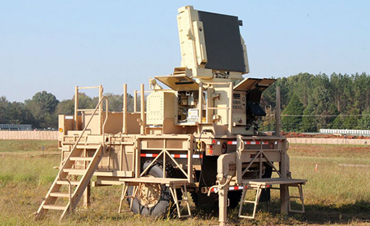
In September 2019, Lockheed Martin was awarded a contract to develop the U.S. Army’s Sentinel A4 radar system, an air and missile defense radar that will provide improved capability against dynamic threats.
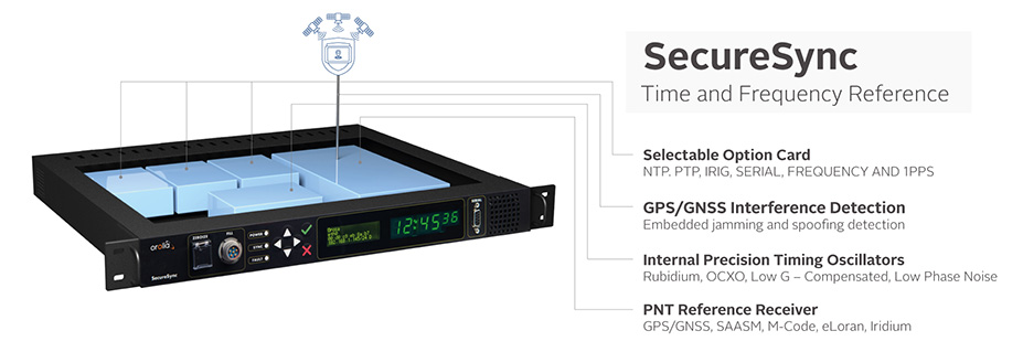
The following November, Orolia Defense & Security announced the availability of M-code military GPS receivers in its flagship SecureSync — the first time server approved by the Defense Information Systems Agency.
Orolia is supplying SecureSync units for Lockheed Martin’s Sentinel A4 radar. (Photo U.S. Army)
This May, Orolia delivered a shipment of M-code-enabled SecureSync mission timing and synchronization units to Lockheed Martin, marking a key milestone for the Army program. SecureSync with M-code provides enhanced resilient positioning, navigation and timing (PNT) capabilities and improved resistance to existing and emerging GPS threats, such as jamming and spoofing.
Lockheed Martin selected Orolia’s SecureSync M-code as the A4 system’s resilient time and frequency reference solution in part due to its modular, open architecture – the same characteristics that are the cornerstone of the radar’s design – making integration a simple process and ensuring future upgrades.
“As a trusted Lockheed Martin partner, Orolia is proud to support the development of the Sentinel A4, which will be a key asset to our warfighters for decades to come,” said Hironori Sasaki, president of Orolia Defense & Security. “Making M-code available now in a readily configurable and scalable form factor is a critical step in advancing our forces out in the field, whether in the air or on the ground,” Sasaki added.
The next-generation of U.S. military systems are fortified with M-code, and Orolia leads the industry in M-code solutions for navigation warfare (NAVWAR) environments.
Orolia is supplying SecureSync units for Lockheed Martin’s Sentinel A4 radar. (Photo U.S. Army)Image: Orolia
The U.S. Army’s Assured Positioning, Navigation and Timing/Space Cross-Functional Team has approved the Navigation Warfare Situational Awareness Abbreviated Capability Development Document (A-CDD), signed March 25.
The A-CDD validates the operational need and enables experimentation and rapid prototyping for NAVWAR-SA capabilities for the warfighter.
NAVWAR is deliberate offensive and defensive actions to assure friendly use and prevent adversary use of positioning, navigation and timing information. NAVWAR supports Multi-Domain Operations as an enabler to precision fires, movement and maneuver, force tracking, and a host of data networks that tie personnel and weapon systems together into a joint or coalition force.
NAVWAR-SA provides the capability to detect, identify and locate sources of interference that deny or degrade reception of PNT. It is intended to validate PNT signal integrity and provide users with indication and warnings of the presence and intensity of interference.
NAVWAR-SA will also characterize the operating environment through the integration of multiple sensors that are able to detect, identify and geolocate sources of intentional and unintentional interference.
William Nelson, Director, APNT CFT
“This A-CDD will enable us to accelerate critical NAVWAR technology development and streamline the process of expediting an operationally relevant system to our warfighters,” said Willie Nelson, director for the APNT/Space CFT. “This capability will enhance our ability to provide real-time situational awareness of PNT reliability to soldiers and commanders on the battlefield, which will enable Long-Range Precision Fires and support freedom of maneuver of large scale ground combat operations.”
NAVWAR-SA will give the Army Forces the ability to “sense” the PNT environment in real-time, allowing commanders and units to maneuver with confidence and with precision when the global positioning system is degraded or denied. This is critical element of NAVWAR operations.
The APNT CFT coordinated with organizations across the modernization enterprise to get the NAVWAR-SA A-CDD approved. The Army Capability managers for Space and High Altitude played a major role in developing the written requirement and getting it through the approval process.
“The requirements provided in the NAVWAR-SA A-CDD are a first step in developing dedicated NAVWAR capabilities for our soldiers and are a key enabler in enhancing lethality in combat operations,” said Col. Tim Dalton, Army Capability manager for Space and High Altitude director.
The A-CDD details methods to leverage new and existing solutions for rapid prototyping, testing and soldier assessment. The APNT/Space CFT will utilize the “buy, try and decide” process to accelerate the development of critical enabling technologies and streamline the process of transitioning a scalable, interoperable and agile capability to the field. This process will inform NAVWAR-SA requirements for current and future Army systems.
“NAVWAR-SA will strengthen the Army’s ability to conduct military operations in PNT-challenged environments,” said David Pinckley, NAVWAR director for the APNT/Space CFT and chairman of the NATO NAVWAR Capabilities Team. “The unfortunate reality is that our systems will continue to be challenged by our adversaries so we are working with our joint and coalition partners to preserve military capabilities while mitigating impacts of interference.”
NAVWAR is one of the three APNT/Space CFT Signature Efforts, which will deliver offensive and defensive NAVWAR capabilities in conjunction with existing Department of Defense NAVWAR policies.
Joint and coalition forces conducting military operations will employ NAVWAR-SA to coordinate and implement mitigating actions to overcome PNT challenged environments.
The APNT/Space CFT plans to assess and test NAVWAR-SA prototypes later this year, during Project Convergence 21 and the CFT’s annual PNT Assessment Exercise at the White Sands Missile Range, New Mexico.
BAE Systems has received a $247 million contract from the U.S. Space Force’s Space and Missile Systems Center to design and manufacture an advanced military GPS receiver and next-generation semiconductor.
The technology will provide positioning, navigation, and timing (PNT) capabilities to warfighters so they can execute missions in challenging electromagnetic environments.
The Military GPS User Equipment (MGUE) Increment 2 Miniature Serial Interface program will provide improved capabilities for size-constrained and power-constrained military GPS applications, including precision-guided munitions and battery-powered handheld devices.
The program will focus on the certification of an advanced application-specific integrated circuit (ASIC) and the development of an ultra-small, low-power GPS module.
Both products will work with the next-generation military M-code signal technology, which provides reliable GPS data with anti-jamming and anti-spoofing capabilities to protect against electronic warfare threats.
“This program enables us to further develop our core M-code technology to deliver high-performance, next-generation GPS capabilities,” said Greg Wild, director of Navigation and Sensor Systems at BAE Systems. “Our M-code receiver and next-gen ASIC will enable secure and reliable military GPS capabilities in a broader range of platforms.”
BAE Systems’ Precision Strike business has 45 years of military GPS experience and more than 1.5 million GPS devices on over 280 platforms around the world. The company is currently producing M-code GPS receivers in multiple form factors, including a low power, small form factor M-code solution.
Additional prototypes are in development for ground, weapons and airborne mission applications, and the company’s M-code GPS products are available to U.S. allies via foreign military sales.
Work on the program will be conducted at the company’s facility in Cedar Rapids, Iowa.
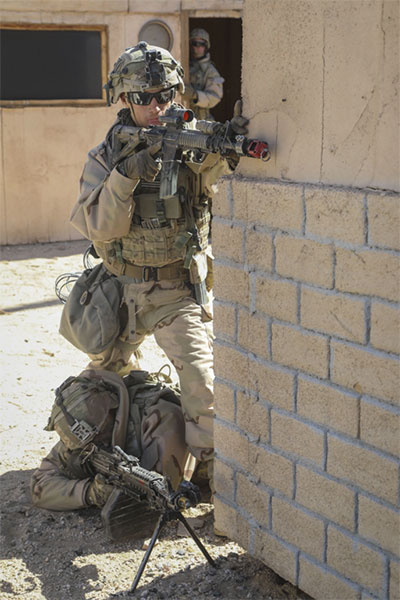
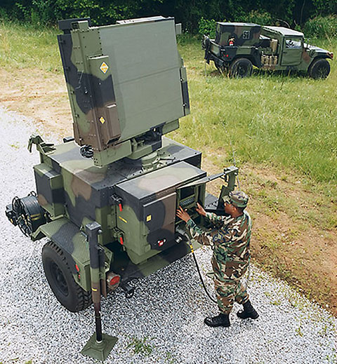
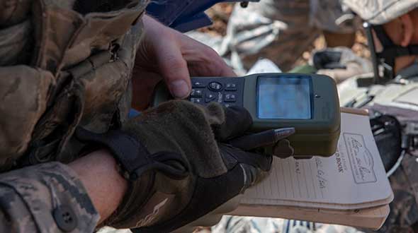
Feature image: An Airman with the 374th Security Forces Squadron uses a Defense Advanced GPS Receiver (DAGR) to track the team’s current during a 2018 field training exercise at Camp Fuji, Japan. (Photo: Senior Airman Matthew Gilmore/U.S. Air Force)
A new system, called WarLoc, makes it possible to locate warfighters and first responders in GPS-denied environments.
Created by Robotic Research, a manufacturer of autonomy and robotic technology, the system provides localization and positioning data for teams entering underground facilities and traveling inside buildings and in urban canyons.
According to the company, multiple systems — including, besides WarLoc, robotic systems, UAVs and manned vehicles equipped with its technology — collaborate to enhance accuracy and maintain the localization of teams.
Its system, the company said, is unique in that “it has very small 3D position error in such a small package” and its filtering algorithms, rather than being centralized, are “distributed and opportunistic in nature to provide the best solution given the communications available.”
In January, Robotic Research received a $16.5-million order for WarLoc from the U.S. Army Product Manager Sets, Kits, Outfits and Tools (PM SKOT) to support forward-deployed U.S. military personnel. The company will deliver the WarLoc units to equip four deployed U.S. Army Brigade Combat Teams. The first batch has been shipped. The procuring organization, PM SKOT, provides Army and Joint Services oversight of the lifecycle for all sets, kits, outfits and tools used by U.S. soldiers.
Distributed System
A self-contained localization system typically relies on GNSS signals, when available, complemented by inertial navigation. By contrast, the WarLoc is a distributed system meant to work as a team, said Alberto Lacaze, Robotic Research’s co-founder and president. The problem, he explains, is how to filter these devices. Centralized approaches, in which every device sends its information to a central computer that does all the filtering, “work very well for an incident commander with a group of first responders going into a building, where the distances are relatively small.” However, he pointed out, they do not work when communications go down.
The alternative approach is to filter the information opportunistically, in a distributed fashion, which is what WarLoc does. In GPS-denied environments, “there is a process that synchronizes all the nodes once the communications have been established,” Lacaze said. “However, if you have, for example, two team members that are each in their own radio bubble, their solutions will continue to be optimized and other team members might be in their own bubbles, so their solution is also being optimized. If these two teams get in contact, their information will get synchronized and collectively optimized.”
The system, he adds, is “heavily reliant on the inertial solution and dead reckoning.” The more units can communicate and share data, the more accurate the navigation solution is. “In a relatively small package, we can achieve better than 1% error of distance traveled for a single unit,” said Lacaze. “Once you have multiple units communicating and measuring with each other, the solution gets significantly better.”
WarLoc, which contains all the required hardware and software, connects to a system used by first responders and the Department of Defense’s Android Tactical Assault Kit (ATAK) also being used in GPS-enabled areas. “Our system can be used not only for tracking humans, but also for tracking animals and other devices, such as robotic systems or vehicles,” Lacaze said.
Relative Localization
On the commercial side, the company has created a kit for autonomous shuttles and is deploying it in about 20 cities around the world. Like WarLoc, this device also works in GPS-denied areas, such as on an underground shuttle on a university campus. “We just won a contract to automate the busses that go through the Lincoln Tunnel,” Lacaze said.
Busses or shuttles using Robotic Research’s system “learn landmarks in the area that they are traversing and use them as an aid in localization, in conjunction with inertial units,” Lacaze said. “The vehicles learn their surroundings.” They don’t care about their absolute position, he explained, only about their relative position with respect to those areas. This is similar to pre-GPS directions like “Make a left at the post office, then a right at the gas station.” They can also use a common landmark. “If the first vehicle is seeing a certain building and knows its lat/long and the second vehicle saw that building some time ago, it can measure its distance from it using its own inertial system.”
While warfighters communicate their position information via their personal tactical radios to ATAK, which then shares it through its current radio infrastructure, vehicles on the road communicate it through dedicated short-range communications (DSRC) radio, a cell network, or some other network.
Other Robotic Research Programs
Robotic Research’s technology supports a range of robotics and autonomous vehicles in GPS-denied environments, including shuttles and buses for public transportation, hybrid unmanned aerial and ground vehicles (UAVs and UGVs), and trucks in the U.S. Army Autonomous Ground Resupply (AGR) Expedient Leader-Follower program.
The company is the prime contractor on several Army programs, including AGR, which consists of robotic trucks that the Army will begin to deploy. “We have delivered close to 100 of those trucks,” said Lacaze. “So, for example, if you are in a convoy and you need to know whether your warfighters are inside or outside a truck, WarLoc can tell you.”
Robotic Research’s AutoDrive autonomy kit, which can be retrofitted to vehicles of all sizes, provides autonomous functionality on surfaces ranging from urban-improved roads to off-road terrain, while the vehicle collects and analyzes data. The technology provides automation to one of the largest international shuttle providers as well as to the largest U.S. manufacturer of commercial buses, according to the company.
In February, the company announced it will begin testing totally unmanned, fully autonomous, low-speed shuttles in the second quarter of this year. It will initially involve attendants in fixed on-site locations, then will aim to move attendants to an offsite safety-monitoring facility.
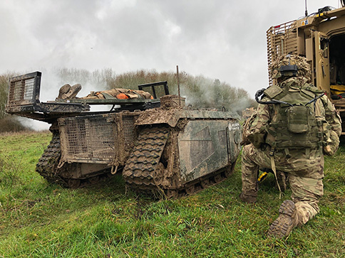
In December 2018 near Salisbury, England, four Milrem Robotics’ and QinetiQ TITAN unmanned ground vehicles (UGVs) were put through three weeks of rigorous tests by British troops during the Army Warfighting Experiment 2018 (AWE18).
The goal was to determine how new unmanned technologies can enhance soldier’s survivability and effectiveness on the modern battlefield.
The modular base can be adapted for various missions, including casualty retrieval. (Photo: Milrem Robotics)
The test was conducted in three phases: conduct combat operations without the benefit of new technologies; conduct combat operations using new technologies but without changing tactics; and, lastly, conduct combat operations using new technologies and adapting tactics according to the capability that the new technology provides.
The UGVs were used in a number of different roles with missions conducted in urban, open and forested terrain.
In remote-control mode, a command-and-control station allows the operator to receive real-time sensor data from the UGV and to transmit command data to the vehicle through a tactical data link. Various third-party sensor packages can be installed.
Of the four Milrem UGVs, two were deployed by Milrem Robotics and two by QinetiQ. The Milrem-fielded systems included one configured as a casualty evacuation and logistical support unit and a second unit equipped with a tethered multi-rotor drone pod provided by Threod Systems.
One of the four UGVs was TITAN Strike, a prototype system carrying a Kongsberg remote weapon station, fully controlled by a remote operator and using QinetiQ’s Pointer system as a means of integrating the capability with dismounted infantry.
The second system, TITAN Sentry, also enabled with Pointer, featured a Hensoldt-provided sensor suite including electro-optical and thermal-imaging cameras and a battlefield radar.
Airbus Defence and Space is celebrating the 25th anniversary of Eagle Vision, its lightweight deployable imagery downlink ground station designed to process and distribute commercial satellite imagery in near-real time to support U.S. Air Force and Air National Guard missions in homeland security, combat and disaster relief.
Eagle Vision allows downloading and processing of unclassified commercial satellite imagery directly in the field, as the satellite passes overhead, supporting military leaders, even in remote areas and non-anticipated operations. Imagery provided by this system supports wartime operations, natural disaster and relief efforts as well as Homeland Defense preparations.
“Today we celebrate an uninterrupted success since 1993,” said François Lombard, director of the intelligence business at Airbus Defence and Space. “Since then, Eagle Vision has become a valuable source for commercial imagery exploitation for the U.S. Air Force and many entities within the U.S. government, to provide fresh, near-real time satellite data for information extraction in preparation for mission critical applications.”
The system receives and processes SPOT 6 and 7, TerraSAR-X and Pléiades images, and is also capable of processing Landsat, Radarsat, RapidEye, Cartosat, Ikonos, Cosmo-SkyMed and Resurs-DK data.
The Eagle Vision Program has been a valuable asset within the U.S. Air Force for the past 25 years, the company said. The program enables warfighters, first responders and planners to have situational awareness so that they can plan, execute and deliver mission resources efficiently and effectively, Airbus said.
Five Eagle Vision systems have been developed and sustained 24/7 by Airbus Defence and Space for the last 25 years. They are assigned to:
Ramstein Air Base, Germany
San Diego Air National Guard Station, California
McEntire Joint National Guard Base, South Carolina
Surrounding sounds may not be a common way of determining location. But on the battlefield, warfighters need to know the direction of gunshots to enable a proper response.
Weighing 12 ounces, the Boomerang Warrior-X by Raytheon BBN Technologies provides immediate hostile fire location awareness to individual soldiers and gives unit leaders shooter grid coordinates, according to the company. These situational awareness enhancements improve coordinated team responses to hostile fire.
Incoming shot announcements are transmitted to a built-in speaker or an earpiece while a lightweight display provides range and azimuth of the shooter position. As the soldier moves, the system compensates for the soldier’s motion and continually updates the threat’s location on a wrist display.
The Boomerang Warrior X system.
This summer, an undisclosed Gulf nation has awarded a direct commercial sales contract to Raytheon BBN Technologies valued at more than $10 million for the delivery of 2,000 Boomerang Warrior-X systems during the next 12 months.
“This technology is a proven life saver on the battlefield,” said Ed Campbell, president of Raytheon BBN Technologies. “Boomerang delivers the best performance of any available shooter detection system today at the lowest cost.”
Raytheon BBN Technologies is a wholly owned subsidiary of Raytheon Company.


 Eagle Vision allows downloading and processing of unclassified commercial satellite imagery directly in the field, as the satellite passes overhead, supporting military leaders, even in remote areas and non-anticipated operations. Imagery provided by this system supports wartime operations, natural disaster and relief efforts as well as Homeland Defense preparations.
 Surrounding sounds may not be a common way of determining location. But on the battlefield, warfighters need to know the direction of gunshots to enable a proper response.