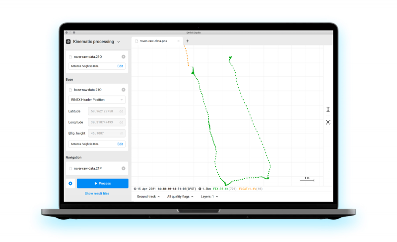
Emlid has released Emlid Studio, a new post-processed kinematic (PPK) application designed specifically for post-processing GNSS data. The app is free and available for Windows and Mac users.
Emlid Studio features a simple interface to make post-processing easy. The app allows users to convert raw GNSS logs into RINEX, post-process static and kinematic data, geotag images from drones (including DJI brand), and extract points from survey projects completed with Emlid’s ReachView 3 app.
With Emlid Studio, users can post-process data recorded with Emlid Reach receivers and other GNSS receivers or NTRIP services. Post-processing requires RINEX observation and navigation files. Raw data in UBX and RTCM3 format also can be used — Emlid Studio will automatically convert them into RINEX.
The post-processing workflow is straightforward. Users can receive precise positioning of a single point or track depending on the positioning mode. Users can simply add several RINEX files and enter the antenna height, click the Process button, and Emlid Studio will do the rest. Once the resulting position file is ready, the plot will show the result.
Another tool is available for the users of Reach receivers and the ReachView 3 app. The Stop & Go feature allows users to improve the coordinates of points collected in single or float modes.
Geotagging for drone mapping. Adding geotags to images’ EXIF data requires aerial photos and the POS file with the events. Emlid Studio also provides a chance to update data from the RTK drone in case of a float or single solution during a survey. A set of RINEX logs from a base and drone, an MRK file and images from the drone are dragged and dropped into specific file slots, providing result in seconds.
Ultra stable for low jitter and phase noise applications
The RHT1490 series of high-frequency and low-jitter ultra-stable TCXOs are available in frequencies from 50 MHz to 204.8 MHz. It delivers telecommunications-grade stability with a low real mean squared (rms) phase jitter of <200 fs (12 kHz–20 MHz). The platform’s frequency output enables lower system jitter, allowing communication system architects to optimize noise budget and performance. It can serve as a reference clock for SyncE and packet clock requirements (ITU-T G.826x and G.827x). It works with both discrete and integrated IEEE 1588 solutions, providing medium-term stability for low loop bandwidth applications. Its ultra-low noise floor performance, combined with system phase locked loop filtering, helps achieve very low system clock rms jitter numbers required by reference clocks of physical layer devices for high -speed interfaces (40 G and 100 G applications).
The 50-channel 8835 GPS reference clock serves satellite communications, defense and wireless applications. It has extreme power and interoperability options while maintaining GPS accuracy and reliability. Tracking GPS, the clock exhibits a frequency accuracy of <1 x 10-12 and a 1 PPS accuracy with <50 nanoseconds real mean squared. The proprietary oscillator steering discipline algorithm can enhance the rms accuracy of either the double-oven crystal oscillator or optional enhanced rubidium oscillator for greater depths of accuracy. It operates from –30° C to +60° C with a terminal node controller GPS receiver port.
The Algiz 8X ultra-rugged tablet computer is built for field workers who require a powerful, portable computer for mobile tasks. It offers communication features such as LTE and dual-band WLAN, along with an 8-inch projective capacitive touchscreen for outdoor use. Enabling glove mode or rain mode allows for operation in changing weather. The chemically strengthened glass survives an impact test in which a 64-gram steel ball is dropped on the screen 10 times from a height of 1.2 meters. The Algiz 8X has optional active capacitive stylus. Built-in features include Windows 10 Enterprise LTSB; u-blox GPS and GLONASS; WLAN a/b/g/n/ac; BT 4.2 LE; a rear-facing 8-MP camera with autofocus and LED flash; and 4G/LTE.
The X-52 entry-level machine control system for excavation features the new intuitive MC-X1 controller, compatible with all brands and models of excavators. Its reliable and rugged TS-i3 tilt sensors detect the precise positioning of the boom, stick and bucket at all times. Later this year, the X-52 will be upgradeable to a full 3D system with GNSS. The X-52 not only allows operators to work faster and with better accuracy, but also promotes a safer work site by keeping grade checkers out of the trenches. The system is designed to pair with the GX-55 touchscreen control box to offer sunlight-readable indicate grade reference in any climate.
Integrated display and keypad for configuration without controller
The Precis-TX204 receiver is a light-weight, rugged, all-in-one GNSS receiver with a built-in centimeter-accuracy RTK engine, onboard storage and versatile connectivity. The built-in battery can support up to 10 hours of continuous field work. Up to 16-GB SD card support makes field work easier, and the rugged enclosure enables the receiver to work in harsh environment. The receiver is designed for infrastructure applications such as providing differential data or logging observations; centimeter-level position and velocity information; precise tracking for internet of things; precise navigation for UAV and robotics. It supports GPS L1 and L2, and BDS B1 and B2.
The CMA-6024 aviation GPS/SBAS/GBAS sensor, featuring an embedded VHF data broadcast (VDB) receiver, is a complete, self-contained, fully certified, precision approach and navigation solution certified to Design Assurance Level A (DAL-A). Designed as an easy-to-integrate solution for all aircraft, the plug-and-play standalone unit requires no specialized installation or integration support. The new CMA-6024 provides a navigation solution that is fully compliant with automatic dependent surveillance-broadcast (ADS-B) and Required Navigation Performance (RNP). The CMA-6024 includes SBAS Localizer Performance/Localizer Performance with Vertical Guidance (LP/LPV) and GBAS GNSS Landing System (GLS) GAST-C/D precision approach guidance for all aircraft. Built on the success of the CMA-5024, the CMA-6024 is the next step forward, adding a complete GBAS/GLS solution. All CMA-5024 receivers can be upgraded to a CMA-6024.
Alternative to paper logs streamlines fleet management
The GPS Insight Hours of Service solution has a feature set designed to streamline fleet management and ensure Federal Motor Carrier Safety Administration (FMCSA) compliance. Hours of Service bundles an Android tablet hardwired to a GPS tracking device. The ruggedized Electronic Logging Device (ELD) tablet features an intuitive user interface to ensure ease of use for all drivers. The management portal is web-based, secure and accessible via PC, tablet and smartphone. Features include messaging between drivers and dispatch; audible and visual directions using designated truck-specific routes; and e-logs combined with GPS monitoring, alerting and reporting. The GPS Insight Hours of Service Solution offers a simple alternative to paper logs and provides many benefits beyond compliance.
Rugged platform designed for aerial inspection, data collection
The Matrice 200 drone series (M200) is built for professional users to perform aerial inspections and collect data. The folding body is easy to carry and set up, with a weather- and water-resistant body for field operations. It offers DJI’s first upward-facing gimbal mount, for inspecting the undersides of bridges, towers and other structure. It is compatible with DJI’s X4S and X5S cameras, the high-powered Z30 zoom camera and the XT camera for thermal imaging. A forward-facing first-person-view camera allows a pilot and camera operator to monitor separate images on dual controllers. Obstacle avoidance sensors face forward and up and down, and it has an ADS-B receiver for advisory traffic information from nearby manned aircraft.
PCI Geomatics’ STAX UAV image alignment and analysis tool.
Designed to ease image alignment
The STAX UAV image alignment and analysis tool provides automated tools for aligning and analyzing UAV imagery without a full photogrammetric software suite. STAX was built to address the challenges of collecting and aligning multiple UAV surveys of the same location over time. By automating the alignment process, UAV operators can reduce or eliminate the use of ground control points that are traditionally installed and measured in survey sites. Relative corrections can be applied by using one of the surveys in a stack as a reference. Alternately, a highly accurate reference image of similar resolution over the area of interest can be used to automate the image alignment process. Once multi-pass UAV surveys have been aligned, customers can accurately make comparisons between surveys to measure changes over time or perform feature extraction. STAX provides tools to calculate vegetation indices as well as visualization and basic cartographic capability. Stacked data sets
can be exported for deeper analysis.
Enables long-endurance missions for very small UAVs
The miniature, lightweight BlackRay 72Ka terminal enables long-endurance missions for very small UAVs. The ultra-compact airborne SATCOM terminal for unmanned aircraft systems delivers exceptional throughput for its size. Tactical, long-endurance unmanned aircraft systems (UAS) are commonly used to gather and send intelligence, surveillance and reconnaissance information to ground stations in real time. Reliable, high-performance satellite communications are crucial for ensuring uninterrupted broadband connectivity in beyond line-of-sight missions. Weighing less than 5 Kg, the BlackRay 72Ka combines high performance and throughput with minimal footprint.
Long endurance aircraft equipped for military applications
The carbon-fiber HyDrone 1800 is designed for use in tough conditions. The drone is wind-resistant, rain-resistant, cold-resistant and lightweight. Its hydrogen fuel-cell technology provides a flight endurance of 4 hours — 50+ hours when combined with MMC tethered technology. The HyDrone 1800 achieves extended flight time while maintaining altitude limits of 4,500 meters with a payload capacity of up to 5 kg. Constructed for safety and durability, an auxiliary lithium battery starts the fuel cell and provides a backup power source. Hydrogen drones can be flown in extreme temperatures from –10° C to 40° C. Payloads include a thermal imaging camera, low light camera, laser equipment or zoom camera, making the system suitable for many military applications such as intelligence gathering, border patrol, aerial fire support, laser designation or battle management services to tactical military operators. MMC also offers packaged solutions in target acquisition and reconnaissance technology (ISTAR).
Handheld Group, a manufacturer of rugged mobile computers and tablets, has launched the Algiz 8X ultra-rugged tablet computer. The Algiz 8X is built for field workers who require a powerful, portable computer for mobile tasks.
The Algiz 8X offers GPS and GLONASS positioning via u-blox, along with an 8-inch projective capacitive touchscreen that is ultra-bright and built for outdoor use. Enabling glove mode or rain mode allows for operation in changing weather. The chemically strengthened glass survives an impact test in which a 64-gram steel ball is dropped on the screen 10 times from a height of 1.2 meters. The Algiz 8X also comes with an optional active capacitive stylus.
“The new Algiz 8X is the most compact and ergonomic Windows tablet we have ever developed,” said Johan Hed, director of product management.”We’ve pushed the limits of modern field technology with this product, fulfilling customers’ needs for powerful computing, mobility, outstanding screen performance and battery life. We made no compromises.”
Built-in features
The Algiz 8X rugged Windows tablet by Handheld Group. Photo: Handheld Group
The Algiz 8X comes standard with Windows 10 Enterprise LTSB to meet the needs of enterprise customers who value long-term stability. Other features include:
u-blox GPS and GLONASS
WLAN a/b/g/n/ac
BT 4.2 LE
A rear-facing 8 MP camera with autofocus and LED flash
4G/LTE
Expansion options
The Algiz 8X offers LAN port, COM port or barcode scanner options. It also features a “backpack” system that allows users to add custom features and electronics.
Ruggedness
The Algiz 8X is rigorously tested for use in tough outdoor and industrial environments. It’s IP65-rated for dust and water ingression and meets stringent MIL-STD-810G military standards for:
Operating temperature: -20°C to 60°C (-4°F to 140°F) — Method 501.5, Procedure II
Storage temperature: -40°C to 70°C (-40°F to 158°F) — Method 501.5/502.5, Procedure I
Drops: 26 drops from 1.22 meters (4 feet) — Method 516.6, Procedure IV
Vibration: Method 514.6, Procedures I & II
Humidity: 0-95% (non-condensing) — Method 507.5
Altitude: 4,572 meters (15,000 feet) — Method 500.5, Procedure I
Orders can be placed immediately. Units will be in stock in March 2017.
CartoPac International Inc. has added iOS mobile operating system support to its CartoPac software suite. CartoPac also supports Windows and Windows Mobile applications, but the company says the addition of iOS enables it to deliver advanced mobile functionality to a broad range of devices used for geospatial data collection.
“Companies struggle to find single mobile software that supports the diverse requirements and robust functionality needed for both asset inventory and inspection workflows,” says Glenn Vlass, CartoPac’s vice president of marketing and product management, in a news release. “With the recent addition of mobile for iOS, our software gives organizations a single platform to author, publish, deploy and manage mobile solutions for their entire workforce.”
Since its introduction in 2002, the company says the CartoPac suite has been adopted by energy companies, natural resource agencies and municipalities, as well as gas and electric utilities, to manage their assets. CartoPac applications are fully integrated with Esri GIS solutions.
The suite has the ability to configure solutions that leverage data from both the GIS database and other enterprise databases, such as work order management systems.
CartoPac Workflow Manager, a module in the suite, supports configured structured processes for bringing field data back to the enterprise. CartoPac also supports both fully integrated on premise deployments and complete hosted deployments using CartoPac Core.
“Regardless of the field device, the captured or updated data will be complete, consistent and accurate,” Vlass says.
Ubisense Group plc, an enterprise location-intelligence solution company, has released version 2 of myWorld Inspection & Survey. Version 2 of the software offers a host of new features to transform the way utility and telecommunications teams conduct inspections and surveys.
myWorld Inspection & Survey enables field workers to collect inspection data on any mobile device, eliminating paper-based processes and is a dramatic improvement on first-generation software solutions, Ubisense said. Users now have the flexibility to run the system on iOS, Android or Windows and dynamically push both data and application code updates, significantly reducing IT management costs, UbiSense said.
Based on discussions with existing customers, Ubisense has also incorporated a range of new workflow and data capture features to make day to day inspections and management even easier. Users of myWorld Inspection & Survey are now able to:
Carry out multiple surveys concurrently, significantly improving productivity.
Assign multiple crews or surveyors to a single survey or inspection order, enabling support of a wider range of existing business processes without requiring any product customization.
Support for “dual pass” surveys, in which each survey item needs to be visited twice in order for the survey to be regarded as complete.
Enhanced map filtering, to allow users to only display items relevant to the survey(s) that they are currently working on.
Process checks to automatically turn off surveying when the vehicle speed exceeds a specified value, avoiding accidentally marking something as surveyed incorrectly.
“We know that our customers want the flexibility to use any device in the field,” said Peter Batty, Geospatial CTO at Ubisense. “We allow them to run iOS, Android or Windows with a single application giving them more flexibility in device selection and future proofing their hardware decisions.”
The Lehmann L-A 300 drone is designed for mapping.
Lehmann Aviation has rolled out a new version of its OperationCenter, a flight preparation and mission control software program for automatic orthomosaic flights. Also, the company dropped the price for its L-A 300 fully automatic professional drone designed for mapping, because of an uptick in demand and increased production.
The new version of Lehmann OpsCenter, designed for Windows 8.1 tablets and PCs, now includes:
New mission control functions (holding, auto return, non-flying zone)
Terrain awareness during mission preparation, for safer flights in mountain areas
Integration with Google Earth for flight preparation and replay
New easier upgrade and update procedures directly through the web
New options to manage new cameras (GoPro, Canon) for orthomosaics and surveying.
Priced at $2,890, the L-A 300 is a professional drone designed for accurate mapping and digital elevation models (DEMs) that works with the GoPro, Canon S110 and multispectral cameras. It flies automatically for 30 to 45 minutes at a trajectory pre-prepared by the user in the OpsCenter (the range is 18.5 miles).
“In 2014 we significantly increased our production volume thanks to numerous orders from all around the world,” said Benjamin Lehmann, founder and CEO of Lehmann Aviation. “This enabled us to reduce the price for our best-sellers, all L-A-series drones. We also made the decision to follow our strategy of offering really high-tech aerial solutions at fair prices.”
The gvSIG Association has published the final version of gvSIG 2.1. This is the first version based on the new architecture oriented to users, and offers many new features, the association said.
Besides the new functionalities and the correction of a great number of errors that were detected through community collaboration, the association wants to highlight the availability of a distribution for Linux 64 bits and portable versions for Windows as well as Linux.
Along with the gvSIG 2.1 release, gvSIG has published a new gvSIG website that includes the old gvSIG Association website as well as the project website. It will also serve as a knowledge portal about gvSIG technology. The new website features gvSIG’s catalog of products, such as gvSIG Roads or gvNIX.
“We want to take advantage of this announcement to thank all the people that have collaborated in making this new version reality, and all the entities that have counted on the gvSIG Association services to solve their needs on geomatics, helping to guarantee the sustainability of the project,” the association said in a statement.
Features in the latest version include:
Legends
– Expresions
– Proportional symbols
– Graduated symbols
– Dot density
– Quantities by category
– Charts (pies and bars)
– Import/export SLD
Copy/paste geometries
Lateral buffer
Split line
Consecutive numbers function
Duplicated records function
Derived geometries
Chart document
Map sheets (map series)
Connection with OpenStreetMap services
New symbol libraries: Geology, POI Cities, Commerce, Military-APP6, Collective Mapping, Colors, AIGA, Weather
PostGIS 2.x support (raster and vector)
Layout
– Insert chart
– New layout with TOC (table of contents) included.
– New grid functionalities.
Portable views (thematic maps plugin)
Advanced dissolve geoprocess
Labeling
– Advanced labeling
– Halo option
– Always show label option
Raster
– Set projection to layer
– Change data type
– Create multi-file layer
– Convert to grayscale
– Integration of tools in the geoprocessing toolbox
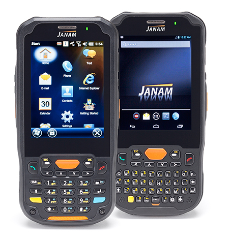
The Janam XM5 series has both Windows and Android OS.
Janam Technologies LLC, a provider of rugged mobile computers that scan barcodes and communicate wirelessly, today announced the launch of its XM5 family of rugged mobile computers. Designed to maximize the mobility investments of enterprise and government organizations, the new XM5 has high-sensitivity GPS and Assisted GPS, and supports Windows Embedded Handheld 6.5 and Android operating systems on the same hardware.
Having both OS enables customers to choose the OS strategy and application migration schedule that best meet their mobility requirements, Janam said.
The XM5 provides the power and flexibility required by mobile workers in field sales, field service, public safety, direct store delivery and transportation and logistics markets, Janam said. Customers can choose between integrated, best-in-class, 1D/2D imager or 1D laser scanner for instant decoding of the hardest-to-read barcodes. Embedded RFID and NFC reading capabilities ensure more efficiency and accuracy in a variety of applications including inventory management, asset tracking, personal identification and mobile point of sale.
“Janam’s XM5 is one of the few rugged mobile computers that allows a customer to migrate from Windows to Android without purchasing new hardware,” said Harry B. Lerner, CEO of Janam. “Packed with all the features that enterprise requires, built to exacting standards of quality and available at an attractive price point, the XM5 catapults Janam to the lead position among hardware providers that not only listen to what customers need, but deliver to those requirements.”
The XM5 comes with either a QWERTY or Numeric keypad and a specially-fortified 3.5-inch VGA display that withstands heavy-duty use. It also offers 802.11a/b/g/n dual-band WLAN and 4G-ready UMTS/HSPA+/HSDPA/HSUPA/GSM WWAN communications for access to high-quality and reliable voice and data inside and outside the four walls.
Built to withstand the rigors of everyday use in the enterprise, the XM5 is sealed to IP65 standards, can withstand five foot drops to concrete and is UL-certified for hazardous environments. In addition, the XM5 ships with a 4000mAh rechargeable Li-ion battery, providing extended battery life as a standard feature, not an optional one.
XM5 Features
Android 4.2 and Microsoft Windows Embedded Handheld 6.5 operating systems
Eos Positioning Systems has introduced a new line of high-accuracy GNSS receivers for smartphones and tablet computers, including both sub-meter and RTK performance for all mobile platforms: iOS, Android, and Windows.
Eos’s entry-level product, the Arrow Lite, is Bluetooth compatible with all mobile devices.
The Arrow 100 is Eos’s advanced real-time, sub-meter GNSS receiver that utilizes both GPS and GLONASS, and is expandable to Galileo, Beidou and QZSS. It offers superior tracking under tree canopy, around buildings and in rugged terrain, the company said. In addition to supporting SBAS in North/Central America, Europe, Northern Africa, Japan, India and Russia, the Arrow 100 also supports OmniSTAR’s worldwide, real-time sub-meter service.
The most advanced Arrow receiver is the Arrow 200, a dual-frequency, multi-constellation RTK GNSS receiver capable of 1-cm accuracy in real time. The Arrow 200 is an iOS-compatible RTK and OmniSTAR receiver that works with all models of iPads and iPhones via wireless Bluetooth connection. An iOS NTRIP app that allows the user to log into any available RTK network. The Arrow 200 will provide quality RTK performance for years to come because it supports current and future satellite constellations: GPS, GLONASS, Galileo, BeiDou and QZSS, the company said. It also supports OmniSTAR’s G2, XP and HP real-time worldwide decimeter services.
“After spending more than 12 years designing high-accuracy Bluetooth GNSS receivers, I believe Eos has set the new standard for high- accuracy GNSS receivers that work across all mobile platforms, no matter if it’s iOS, Android or Windows,” said Chief Technology Officer Jean-Yves Lauture.
All Arrow receivers employ long-range (1-km) universal Bluetooth connectivity so the user can interface to any brand of smartphone or tablet, whether it’s iOS, Android, or Windows-based. A variable-power Bluetooth implementation allows the Arrow receivers to communicate up to one kilometer from the mobile device.
Arrow receivers have been optimized to run all day on battery power. The battery pack is field-replaceable and rechargeable separately. It contains smart charging logic so expensive battery chargers are not needed.
All Arrow receivers have been designed to meet IP-67 specifications for immersion in water and are completely dust-proof so they will survive in the harshest environments.
The Arrow receiver product line is targeted at high-accuracy applications like GIS, environmental, agriculture, electric/gas/water utilities, surveying, machine control, and federal/state/local government.
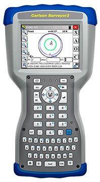
The Carlson Surveyor2, the newest model of Carlson Software’s Carlson Surveyor line of data collectors, was launched at the InterGeo Trade Show in Berlin this week.
The handheld surveyor is on display at Carlson’s Stand 1.037, Hall 1.1, at InterGeo.
Fast, durable and more powerful, the Carlson Surveyor2 is ruggedized, with an IP68 water and dust-resistant ingress rating. Still weighing two pounds, the Carlson Surveyor2 offers increased program memory (now 512MB) and increased non-volatile data storage (now 8 gigabytes), and a 1.0-GHz processor to provide the speed surveyors need in the field. It comes equipped with significantly increased Bluetooth range, up to 1500 feet when paired with a class I device.
The Surveyor2’s QWERTY keyboard eases data entry and is designed to be workable even for those with large hands or wearing gloves. The backlit keys and larger, brighter display screen allow users to work effectively in all lighting conditions.
“Not only did the Surveyor2 retain the durability of its predecessor, but its higher-resolution, easier-to-read display screen also comes with scratch-resistant glass,” said Bruce Carlson, president and founder of Carlson Software. “An added convenience is its enhanced battery life — up to 20 hours.”
The Surveyor2 has kept its easy-to-grip design, being thinner front to back than other data collectors when resting on a table top. The computer runs on Windows Mobile 6.5.3 and Carlson SurvCE 4.0 can be included. SurvCE is the powerful data collection software used around the world.
The Surveyor2 is designed for surveying, stake out, construction layout and GIS mapping. The easy-to-use, tab-based menu and advanced graphics in Carlson SurvCE 4.0 enhance the Carlson Surveyor2’s usability. Options include an integrated GSM cell modem for real-time connectivity, an integrated 5 MP camera with LED illuminator that doubles as flashlight, and a mapping-grade GNSS receiver.
Handheld Group, a manufacturer of rugged mobile computers, has launched the Nautiz X8 rugged PDA. The Nautiz X8 is a handheld computer with superior processing power, screen performance and battery life, the company said. It is built for tough field conditions primarily in GIS, land surveying, public safety, forestry and the military.
Photo: Handheld Group
The Nautiz X8 is built to enable efficient and reliable data collection in tough environments. It has an IP67 ingress protection rating, which means it offers complete protection against dust and sand and can withstand immersion in water. It also meets stringent MIL-STD-810G military test standards for overall durability and resistance to humidity, shock, vibration, drops, salt and extreme temperatures.
The Nautiz X8 features a high-performance Texas Instruments 4470 dual-core 1.5 GHz processor. It has 1 GB of RAM, 4 GB of iNAND Flash and a 5200 mAh Li-ion battery that lasts up to 12 hours on a single charge. It comes with a choice of operating systems — Android 4.2.2 or Windows Embedded Handheld 6.5.3.
The device has a large 4.7-inch ultra-bright capacitive multi-touch screen with chemically strengthened Asahi Dragontrail glass, offering users brightness and protection in any field condition. The unit has an ergonomic design and weighs 490 grams (17.3 ounces).
The Nautiz X8 has a dedicated u-blox GPS receiver, Bluetooth 2.0 and 802.11b/g/n WLAN functionality, as well as connectivity through GSM/UMTS or CDMA phone data transmission. A built-in 8-megapixel camera with autofocus and an LED flash lets users capture visual data quickly and easily. This handheld also features an open architecture and an extension cap system that allows for additional hardware connections such as sensors, radios and other add-ons.
Orders for the new Nautiz X8 can be placed immediately. First deliveries will begin in November.
The Nautiz X8 rugged handheld will be shown first at WEFTEC in New Orleans, followed by InterGeo in Berlin.
CartoPac International Inc. has announced a major new release of the CartoPac Mobile Platform. CartoPac 5.0 extends the mobile platform with support for Windows 8 and introduces the CartoPac Workflow Manager, which provides a structured process to manage the use of geospatial data across the enterprise.
CartoPac will demonstrate the applications and technologies of Version 5.0 in the free CartoPac Mobility Webinar Series beginning on September 30.
The CartoPac Platform is a configurable suite of field and office tools designed to maximize the productivity of crews as they digitally map, inventory and inspect critical assets using GPS-enabled mobile devices. Seamlessly integrating with the Esri ArcGIS Server, CartoPac is used extensively by oil and gas companies, pipeline operators, electric utilities, state/local governments and environmental engineering firms to populate the enterprise GIS and asset-management systems with captured infrastructure information.
The new CartoPac Workflow Manager (CWM) in CartoPac 5.0 provides organizations with a structured workflow to view, edit, validate and approve asset data as it moves from the field back into the enterprise. CWM ensures that individuals responsible for data are notified as it comes into the organization so they can incorporate the data into systems related to work-order fulfillment, risk analysis, integrity modeling and other asset management processes.
CartoPac developed CWM for the management of heavily regulated assets in the field, such as gas pipelines and electric distribution infrastructure. A module within the CartoPac Server, the CWM extension creates an audit trail of all the edits and modifications made to the data sets that represent the monitoring and maintenance of real world assets in the field.
“CartoPac Workflow Manager fills the gap between data collection and enterprise asset management systems to enable organizations to maximize the value of their data,” said CartoPac CIO Scott Crouch. “CWM enables organizations to show regulators they have a structured process for tracking and responding to the conditions of their critical assets and has proven to be key component for assisting companies with their regulatory compliance and integrity management programs.”
Further expanding the capabilities of the CartoPac mobile components, version 5.0 has been optimized for the Windows 8 operating system running on standard GPS-enabled laptop computers and tablet devices. This migration means that crews can use CartoPac to collect and manage asset data in the field on the same hardware devices they will use back in the office to run their daily business applications.
“The attractive cost, integration with GPS and expanded performance of Windows 8 tablets and laptops will enable organizations to put more personnel into the field, ensuring that vital infrastructure is mapped, inventoried and properly managed,” said Crouch “Laptop/tablet-equipped maintenance personnel in the field will now be able to run CartoPac solutions on the hardware they already use for tracking repairs and closing work orders.”
To demonstrate the advantages of enterprise asset management, CartoPac has launched the CartoPac Mobility Webinar Series, which will feature applications by electric and gas utilities and highlight new mobile technologies. The first webinar, “Applying New Mobile Technologies to Electric Utility Inspections,” will be presented with EDM International Inc., a Colorado electric utility services company.
The free “Applying New Mobile Technologies to Electric Utility Inspections” webinar will be held on September 30, 2014, at 4:00 pm Eastern Time. To register, click here.