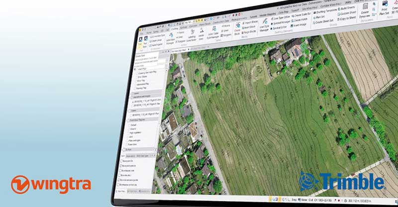
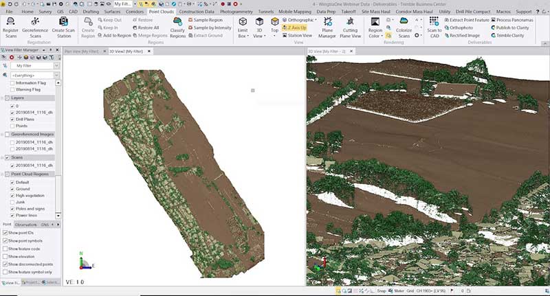
With Wingtra’s latest software release, surveyors and geospatial professionals can now directly import WingtraOne drone data into the Trimble Business Center (TBC).
According to Wingtra, the new integration seamlessly combines WingtraOne high-accuracy drone data within TBC, optimizing drone mapping workflows for survey and construction projects within a single software platform.
The integration allows users to drag and drop data into the software suite. Automated point cloud tools, such as classification and feature extraction, can then be used to quickly generate surface models, topographic plans and as-built deliverables.
Photo: Wingtra
“It’s a solid step forward to enable our data to work smoothly with Trimble Business Center,” said Francois Gervaix, Wingtra’s geospatial expert. “TBC is a reference software in the industry, because of its success as a data hub for construction and geospatial workflows. Optimizing the workflow lets TBC users smoothly integrate data from the fastest drone data capture platform on the market — WingtraOne.”
This latest Wingtra software release that introduced JobXML (TBC file format) compatibility also brought various other product updates. Namely, high-altitude flight capabilities, longer flight times and more intuitive battery level readings in-flight, Wingtra added.
Wingtra and 3DR, producer of the Site Scan drone data platform, have signed a partnership agreement to benefit the mining and surveying industries.
Wingtra’s VTOL drone WingtraOne and Site Scan form a complete aerial surveying solution, including highly efficient aerial data collection, post-processing and analysis. Through the partnership, 3DR now endorses the WingtraOne as the preferred fixed-wing drone for its Site Scan platform.
Wingtra and 3DR will distribute the complementary solution across a range of industries, focusing particularly on mining and surveying teams. 3DR will sell Wingtra products through its existing distribution partnerships across North America, Europe and Australia, and Wingtra will sell Site Scan worldwide.
“We’re thrilled to officially partner with Wingtra and make a fixed-wing VTOL drone available to our customer base,” said Chris Anderson, 3DR CEO. “We’re looking forward to deepening this partnership and continue making Site Scan and Wingtra the go-to drone solutions for mining teams across the world.”
Mining and surveying professionals are turning to fixed-wing vertical take-off and landing (VTOL) drones because of their ability to take off and land vertically as a multicopter but fly as fast a fixed-wing craft.
The WingtraOne VTOL drone offers safe launch and land, as well as high resolution and broad coverage in a single flight with absolute accuracy down to 1 centimeter (0.4 inches).
Users can upload photos collected with the WingtraOne into the Site Scan cloud-based web application to process them into high-resolution maps and 3D models.
Site Scan users include mining firms such as Newmont, Newcrest and Gerdau. Site Scan offers an all-in-one software program for analyzing drone-captured data with a suite of measurement tools, securely sharing them with teammates and stakeholders, and exporting them for use in CAD, mine planning and geological software.
“Our partnership with 3DR lets our customers analyze high-precision aerial data directly in Site Scan — in a lot of cases without any additional tools,” said Basil Weibel, founder of Wingtra. “Together, WingtraOne and Site Scan make up a complete solution and we are very excited to offer this bundle to the industry.”
Wingtra shares advantages of using its WingtraOne vertical-take-off-and landing (VTOL) drone at Intergeo 2018 in Frankfurt, Germany. The surveying drone offers large coverage, high resolution and accuracy down to 1 centimeter.
Background image: iStock.com/imaginima; B-roll footage courtesy of Wingtra
The Commercial UAV Expo takes place Oct. 1-3 at the Westgate in Las Vegas. The expo brings together more than 3,000 professionals, and provides both education and an exhibit floor filled with high-precision UAS technology.
LidarUSA showcases revolutionary tech.LidarUSA will be at Booth 515, discussing its lidar products and the impact of the technology on the UAV industry.
“Whether you’re documenting a road accident scene at night, designing rice field irrigation systems or surveying archeological sites under dense forest canopies, advances in 3D mapping and geospatial data capturing are making these once time-consuming tasks, quicker and more efficient than ever before,” the company explains.
Pilot a WingtraOne. Wingtra, in collaboration with RDO Equipment Co., will be attending Commercial UAV Expo, North America’s trade show and conference for the commercial drone market.
Wingtra will be demonstrating its WingtraOne drone on Wednesday, Oct. 3, at the William Bennet R/C Airfield. The demonstrations begin at 8 a.m., with hotel pick-up provided at 7:30 a.m.
Register here for the demo, or visit Wingtra’s booth is 1404 in the Westgate.
RIEGL exhibits sensors, systems.RIEGL will be exhibiting at Booth 309 during the conference, showcasing its unmanned sensors and systems as well as the miniVUX-1UAV.
The miniVUX-1UAV is integrated onto a DJI-M600 with the RIEGL Integration Kit 600. It is a user-friendly, cost-efficient miniaturized lidar sensor for unmanned laser scanning to acquire survey-grade measurement data through the use of remotely piloted multi-rotor, rotary-wing or fixed-wing UAVs for a variety of applications.
The miniVUX-1DL. (Photo: Riegl)
The miniVUX-1DL is a downward-looking lidar sensor for unmanned laser scanning with a special design tailored to meet the needs of corridor mapping tasks through its downward looking capability, its optimized field of view, and its small size.
Microdrones offers post-show event.Microdrones, which offered a series of workshops during the expo, is providing an in-depth technical symposium following its conclusion. The Key presenter is Mohamed Mostafa, director of mdSolutions at Microdrones.
On Oct. 4, expo attendees are invited to join ASPRS for an additional in-depth technical symposium led by Mostafa. Registration at the Commercial UAV Expo is required and the ASPRS UAS Symposium is an optional add-on event.
The symposium features detailed technical discussions on high-precision mapping by drones including lidar, photogrammetry, GNSS, inertial, datums, post processing, best practices and quality control. Real-world datasets acquired in the U.S. and Canada will be used to demonstrate the concepts and best practice of precision mapping by drones.
Other presenters at the symposium are:
Karen Schuckman, PLS, CP, CMS, Pennsylvania State University
Special section, October 2018 GPS World. Cover photo: PrecisionHawk
If you blink, you might miss something! The examples here represent only a fraction of this booming field, but they show how diverse drone use has become. Interspersed among them, this article offers further insights on technology integration, the regulatory outlook and the economic future of this fast-moving industry.
By Tony Murfin, Contributing Editor, UAV & Professional OEM
Capturing where the drone industry has been this year and where it is headed in 2019 resembles trying to describe a Florida thunderstorm: how can there be so much rain so quickly, how long will it last, and what will the landscape look like afterwards? (I’m writing this during just such a deluge near Venice on the Gulf Coast.)
The UAV/UAS industry has grown at such an amazing rate, it’s almost impossible to count or describe all the applications that have become normal practice, not to mention the number of companies involved in either making drone platforms or supplying drone integrators with sensors: GNSS, inertial, lidar, cameras photographic, thermal, infrared, video and more.
From accident reporting to crop monitoring to infrastructure inspections, drones are, so to speak, on the rise. This year we have seen substantial increases in investments by equipment suppliers, continuing funding for military businesses, prototype systems for remotely identifying and even taking down drones, and vastly expanded use in mapping and survey.
As precision guidance, autonomous operations, high-definition geocoded images and high-volume data processing all improve, drone usage will continue to increase. OEM receiver manufacturers, sensor suppliers and data-handling companies play key roles in development, and stand to profit thereby.
The Delair Septentrio UX11 mapping UAV. (Image: Septentrio)
In particular, use of drones is growing in land management, construction, mining and farming. An open-pit mine operation can be supported through detailed drone inspection producing high-resolution images. Processed images and data enable keeping tabs on inventory, site changes over time, identifying best areas for further extraction, and monitoring and managing vehicle movement. These tasks required huge amounts of time in the past. Drone overflight and processing tools condense all the effort as well as producing enhanced results to enable faster and clearer decision-making.
Surveillance and reconnaissance are probably the biggest military drone applications. Carrying payloads that include color video cameras and infrared night vision cameras, more than 19,000 drones are now in the arsenal of the U.S. Army, Air Force, Marines and Special Ops, and more have gone to other nations’ militaries. Some fly at relatively low altitude, with limited range and powered by a single quiet electric motor; these drones have become essential in gathering forward-situation intelligence.
The following examples represent only a small part of the industry. I selected them here to show how diverse drone use has become. Interspersed among them, I’ll offer further observations on technology integration, the regulatory outlook and the economic future of this fast-moving industry. If you blink, you might miss something!
Accident Investigations
In the past, when police arrived at a serious traffic accident, investigators had to use tape measures and roller wheels to construct an accurate physical record of the incident. More recently, police have used laser measuring tools but this still entails time-consuming procedures and produces traffic back-ups. Now police departments have started to collect highly accurate aerial images of traffic incidents using drones, and it’s proving quicker and more efficient.
UAVs collect photos and videos, and software then stitches multiple high-resolution images together into a 2D or 3D map. With geolocation annotation provided by the drone, investigators can then take measurements directly from visual accident records.
Previously, an investigation could take up to three hours gathering information manually, but with a drone overflying and documenting an accident this might be reduced to around 45 minutes. This clearly saves time and money for the police as well as drivers who suffer shorter traffic delays. With an investment of about $15,000 in drone hardware and training, payback can happen pretty quickly.
Overall UAV Market Growth
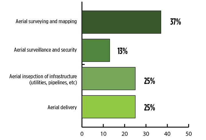
What is the killer app for drones? What professional UAV market sector will most powerfully drive adoption and influence new regulations for unmanned aerial vehicles? (Source: GPS World 2018 State of the GNSS Industry survey)
The drone logistics and transportation market was estimated to be valued at US $11.20 billion in 2022 and is projected to reach $29.06 billion by 2027, at a combined annual growth rate (CAGR) of 21.01%, according to India-based MarketsAndMarkets Research, in its May 2018 report.
The logistics and transportation market was defined to include warehousing, shipping, infrastructure, software, military, freight, and even passenger and ambulance drones. “The increasing use of unmanned aerial vehicles in civil and commercial applications for faster delivery of goods is one of the most significant factors expected to drive the growth of the drone logistics market,” stated the report.
The shipping segment is indeed projected to grow at the highest CAGR, as drones will see increasing use to transport a range of products from small packages to medical supplies and food. Venture capitalist investment in this market has been substantial as well as significant commitments by companies such as Amazon, Google, and Walmart in research and development to commercialize drone delivery services.
Couple that with another report from the same company report on the drone analytics market, valued at $1.17 billion in 2016 and projected to reach $5.41 billion by 2022, at a CAGR of 28.11% from 2017 to 2022. The drone analytics market was considered to encompass agriculture and forestry, construction, insurance, mining, utilities, telecommunications, oil and gas, and scientific research.
Both reports note that “The imposition of restrictions by various government agencies on the use of UAVs in civil and commercial applications is one of the major challenges faced by the drone logistics and transportation market.”
In February of this year, MarketsandMarkets estimated that the overall UAV market was valued at $18.14 billion in 2017 and projected to reach $52.3 billion by 2025, at a CAGR of 14.15%.
Agriculture
Results of a survey of 269 farmers by Munich Reinsurance America indicate that three quarters of all farmers in the U.S.— from those with less than 100 acres to those with more than 5,000 — have either begun to use drones for precision agriculture, and monitoring crops, livestock and soil conditions, or are thinking about using drones. Roughly half of these farmers contract out the work to drone service suppliers and most use drones either daily or more than once a week.
Sensor Integration
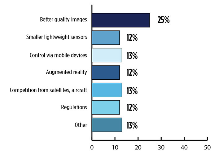
What is the biggest challenge for the UAV industry? (Source: GPS World 2018 State of the GNSS Industry survey)
As the size, weight and power (SWAP) and the accuracy of sensors continue to improve, drone use will continue increasing steadily. OEM receiver manufacturers, sensor suppliers and data-handling companies play key roles in this vital and ongoing development, and stand to profit thereby.
Making it all work is a combination of sensor payloads gathering inertial and GNSS location, stills and video, lidar, thermal and hyperspectral data; the secret sauce lies in how the data is processed and presented to users. All these areas show significant growth. The following are only a few key examples.
Lidar. Light detection and ranging (lidar) detects and measure the distance of an object or surface from an optical source, in this case a hovering or cruising UAV. GPS and inertial provide geo–referencing per each scan point.
Lidar has seen increasing application in surveying and engineering, GIS mapping, accident scene reconstruction, topographic and coastline mapping, digital elevation model and digital surface model generation, mining and quarries, gas and oil pipelines, railroads and other infrastructure. As hardware costs decline, software begins to play more and more of a major role, becoming a larger part of the solution in every way.
The M200 Snoopy series lidar package from LidarUSA is designed specifically for integration aboard the DJI M200 UAV. The laser scanning has a 100-meter maximum range, yielding 4-5 cm accuracy. It carries a tactical grade L1/L2 GPS/IMU unit and weighs 1.63 kg.
Inertial Miniaturization. UAVs are driving even further size-downs of other navigation sensors as well.
As just one example, the miniature μIMU from Inertial Sense incorporates a magnetometer, barometric pressure sensor, and L1 GPS (GNSS) receiver. Angular rate, linear acceleration, magnetic field, barometric altitude, and GPS location outputs are at 1 KHz with UTC time synchronization.
ADS-B.Aerobits in Poland has developed a high-speed, miniaturized (23.0 x 18.0 x 2.5mm & weighing 2 grams) Automatic Dependent Surveillance-Broadcast (ADS-B) module which provides detect-and-avoid for small UAVs. The module accepts external GNSS position inputs and has high speed on-chip processing which enables processing of thousands of ADS-B signals/second from other aircraft/drones. Aerobits claims a reception range of over 200 miles due to a high-sensitivity RF front-end. With FAA-mandated equipage coming for aircraft in 2020, this potentially offers a detect-and-avoid option for even small drones.
Regulatory Outlook
The Association for Unmanned Vehicle Systems International has been an industry voice for more than 40 years. AUVSI president Brian Wynne recently told Congress what needs to be done to fully integrate UAS into the National Airspace System — a critical step in further drone development and growth.
Initial regulations governing civil and commercial UAS operations are now in place. The FAA’s small UAS rule, known as Part 107, established a flexible, risk-based approach to regulating UAS and reduced many barriers to low-risk civil and commercial UAS operations. Since its enactment in 2016, however, demand for commercial UAS has exploded.
“As of March 2018,” Wynne stated, “more than 150,000 platforms have been registered for commercial use. The FAA expects more than 450,000 UAS to be flying for commercial purposes over the next five years.” That’s three times as many as today!
Waivers to Part 107 permit their holders to operate at night, as well as in certain restricted airspaces, beyond line of sight and over people. More than 1,700 operators across the U.S. have received these waivers.
Continued adoption of unmanned flight will require an expanded regulatory framework that extends the waiver provisions much more widely. There are many challenges to this, particularly security concerns. A key step will be “implementing a remote ID system that identifies any UAS flying in the airspace, in real time.” according to Wynne.
The FAA reauthorization bill recently passed by the House of Representatives calls for rulemaking concerning carriage of property, a necessary step for allowing UAS package deliveries — the next big thing.
Military UAV Business Strong
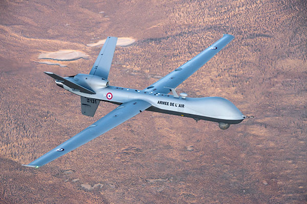
French MQ-9 Reaper. (Photo: DoD press release/UAS Vision)
Military business remains a major source of revenue for the UAV/UAS industry, as demonstrated by the recent award of several contracts to various drone suppliers.
U.S. Naval Air Systems Command recently awarded Insitu a ~$54 million fixed-price contract for four production RQ-21A Blackjack unmanned aircraft systems and eight attrition air vehicles: seven for the Marine Corps and one for the government of Poland. The contract includes ground control stations, launch and recovery equipment, shipboard equipment kits as well as systems engineering and program management support.
U.S. Army Contracting Command recently awarded General Atomics Aeronautical System Inc. (GA-ASI) a Grey Eagle engineering support contract worth ~$11m. Work will be undertaken at the GA-ASI facilities in Poway, CA and will run through to Sept 30, 2019.
GA-ASI has also just won an FMS (Foreign Military Sales) contract worth $123 million for MQ-9 Reaper systems for France – deliveries are expected to be completed by May 2020. An FMS contract is normally how a foreign government procures U.S. government military equipment. The foreign government contracts with a U.S. agency, and the U.S. agency awards a back-to-back contract to the U.S. supplier. In this case, the U.S. contracting authority is the Air Force Life Cycle Management Center at Wright-Patterson Air Force Base.
The U.S. Missile Defense Agency has awarded General Atomics Electromagnetic Systems (GA-EMS), San Diego, California, a contract worth up to ~$134 million to develop, integrate, and flight test an advanced sensor into the MQ-9 UAV. The work will be performed in San Diego, California from August 2018 through October 2021 with realistic flight testing scenarios taking place both within the U.S. and elsewhere.
At the end of August, Boeing won the contest for the U.S. Navy’s unmanned refueling tanker with an $805 million contract award. The award covers the development and manufacturing of an initial four air vehicles. The future MQ-25 Stingray will be the first UAV to operate from U.S. aircraft carriers to refuel and extend the range of several combat aircraft.
L3 Technologies has won a U.S. Army $454M contract to build, deliver and support an electro-optical infrared laser designator for the RQ-7Bv2 tactical UAS. The drone mounted payload will help the Army manage battlespace situational awareness, increase UAS survivability and obtain imagery for target/threat detection.
Counter-UAS Systems
DroneShield out of Australia markets a drone detection and mitigation system, known for its DroneGun, a point-and-shoot device able to disrupt multiple RF frequency bands simultaneously (433MHz, 915MHz, 2.4GHz & 5.8GHz), taking out the communication link to a drone operator — and also GNSS signals when so equipped — up to 1km away.
The full DroneSentry detection system integrates a suite of sensors and countermeasures including radar, optical, RF listening, acoustic, thermal and an RF countermeasure transmitter with greater power/range than the portable DroneGun.
Survey and Mapping
SenseFly recently completed work on a three-year construction project in Northern Ireland to build the new A6 highway. A senseFly eBee Plus drone provided detailed aerial coverage and minimize interruptions with road traffic and ongoing quarry operations.
Adopting an integrated aerial approach enabled the construction contractor to quickly obtain detailed, accurate, professional-grade data, and has helped save time and resources. Reducing the time required in the field and proximity to dangerous quarry sites optimized the mapping task
High-Precision Survey Drone. The TRIUMPH-F1 UAV is built around the JAVAD GNSS TRIUMPH-1M receiver, the company’s high-precision geodetic GNSS receiver with 864 channels to track all current and future GNSS signals.
When used on the ground, the TRIUMPH-F1 can function as a TRIUMPH-1M base or rover. The four motor arms (for eight motors) are detachable. Four screw inserts in the bottom to attach the TRIUMPH-F1 to a pole mount for field use.
The TRIUMPH-F1 features user-friendly mission programming. The four lithium polymer batteries that power the eight propeller motors, arranged in a stacked quad formation.
The TRIUMPH-F1 also has two micro-SD slots for image storage, a SIM card slot, a USB connector for uploading flight plans and downloading collected images, and indicators for satellite tracking and communications. Other indicators are dedicated to flight status and gyro.
Vertical Landing.WingtraOne’s vertical landing technology enables touchdown in confined areas as small as 2 m x 2 m like boats or forest lanes. Combined with a flight range of up to 50 km, this makes large-coverage mapping missions feasible
The vertical-take-off-and landing (VTOL) drone WingtraOne is designed to safeguard its valuable sensors and eliminate wear and tear of the equipment. Instead of broken wings or damaged cameras from belly landings and parachute touchdowns, the WingtraOne lands gently. During the vertical descent, laser sensor data enables the WingtraOne to sense the ground and land safely even on rocky or hilly hilly terrain.
In case of a changing landing environment like a drifting boat or recently parked cars, the landing spot can be adjusted easily.
The WingtraOne works truly autonomously during its entire mission, including take-off and landing. Instead of catapult or hand launches that can cause injuries or damage equipment, the WingtraOne takes off vertically without any human interaction.
Shipping and Logistics
Matternet, based in Switzerland, is testing deliveries using drones under a 3-year program run by the North Carolina Department of Transportation. The NC program is one of 10 authorized by the FAA to evaluate the commercial use of drones.
The objective is to transport small items like blood samples, but initially vials of water will take the ride from a medical office building before landing on a hospital roof. In March, the company was authorized to operate drones over populated areas in Switzerland, carrying samples to hospitals in Lugano.
Items can be securely deposited into the drone station for pick up or retrieved following delivery. A smartphone application is used to authorize pick up and delivery. The item is then scanned for pick up, the station automatically installs the item into the drone for transport, the drone then departs for the assigned destination and on arrival, scanning is required to retrieve the delivered item at the other end.
Conclusion
These examples just skim the surface of an exploding industry which just keeps on keeping on, constantly developing new solutions and applications. High-altitude pseudo satellite drones, drone delivery of goods within minutes of placing an internet order, automated drone facility inspections, power via wireless to keep drones airborne, parachute safety systems for drones….the list goes on and on.
Clearly the UAV/UAS industry has only begun its journey. There are many unexpected places we can look forward to it visiting in coming months and years.
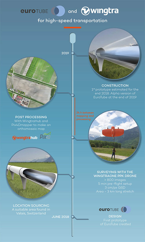
EuroTube is Europe’s first testing ground for high-speed vacuum maglev transportation.
In May, a WingtraOne drone conducted a topographic survey of a construction site where a EuroTube vacuum high-speed test track will be built.
The futuristic project is the European answer to its American counterpart Hyperloop of the SpaceX and Elon Musk fame. The EuroTube project plans to provide a 3-kilometer-long vacuum tube to developers of pod technologies for testing.
The Eurotube test infrastructure for high-speed vacuum transportation will provide an environment free of air resistance to test “pods”, or cars, that can be accelerated to speeds as high as the Boeing 747 in flight. (Photo: EuroTube)
The project proved to be surprisingly challenging from the very beginning. First, the team had to find a long, flat stretch of land for EuroTube’s construction in Switzerland, a country famous for its mountains.
And just as the right location was found in the canton of Valais, another challenge came along. How to survey such a complicated site surrounded with mountains, water bodies, forests and railway tracks? Luckily, the fellow Swiss company Wingtra already had a solution — the vertical-take-off-and-landing (VTOL) drone WingtraOne.
After spending months in research and development of prototypes, the team at EuroTube selected the stretch of land in the Valais region of Switzerland as its candidate location. The chosen construction site is located next to railways tracks. A few water bodies, forests and ditches flank the other side of the construction site, making available a mere 3-meter-wide piece of land for take-off and landing of the drone.
Fortunately, the WingtraOne’s VTOL capabilities were designed with exactly these kind of constraints. But why choose such a peculiar construction site in the first place?
Bringing Europe’s transportation system to 21st century
The answer lies in the technology behind the EuroTube itself. One of the main limitations in speeding objects on ground is the high air resistance, also called drag (drag is a type of friction force acting opposite to the relative motion of any object). By maintaining a low-pressure environment or even a vacuum, this air resistance can be lowered drastically, and hence objects can be accelerated to high speeds.
Technologies such as the EuroTube provide this vacuum environment inside a long tube. Within such tubes, cars called “pods” can be accelerated to speeds as high as 800 km/h, meaning a journey between Zurich and Paris, which currently takes 4 to 6 hours, would be reduced to a mere half an hour. This is the vision driving the EuroTube project, which will provide a 3-kilometer-long vacuum tube to developers of pod technologies for testing.
Aerial surveying of the construction site
Gerard Güell, the construction director of EuroTube, at the construction site with the WingtraOne. (Photo: Wingtra)
Before the construction of the tube could begin, however, the EuroTube team needed to survey the construction site. Looking at solutions that would cut time and cost, Sascha Mark, the technical director at the EuroTube project, reached out to Wingtra in early May.
A partnership between Wingtra and EurtoTube was quickly formed where Wingtra would provide the WingtraOne as well as conduct the surveyof the construction site.
“For a cutting-edge research project involving significant infrastructure, time is of crucial importance,” Mark said. “We were looking at surveying solutions that can provide the dataset required for a construction site quickly without compromising on the accuracy. From this perspective, WingtraOne looked like a viable prospect.”
The survey was conducted on May 21 when Gerard Güell, the construction director at EuroTube, met Adyasha Dash from Wingtra on site. To survey the area quickly with high accuracy, a WingtraOne equipped with an RX1RII camera and post-processed kinematics (PPK) was chosen. As the survey required flights over a straight, flat piece of land, flight planning was done on site, and took less than 5 minutes for the setup.
The wind on site ranged from 2 m/s to 5 m/s. After letting the flight planning app WingtraPilot run a host of automatic pre-flight checks, the drone started its flight to collect aerial imagery at a ground sampling distance (GSD) of 3 cm/px. At the end of two consecutive flights taking less than an hour in total, the drone had collected a little more than 800 individual images.
“It was nearly effortless to conduct the aerial surveying with the WingtraOne,” Güell said. “All we had to do was to walk to the take-off area, double-check the survey area we wanted to cover on the flight planning app, and hit go.”
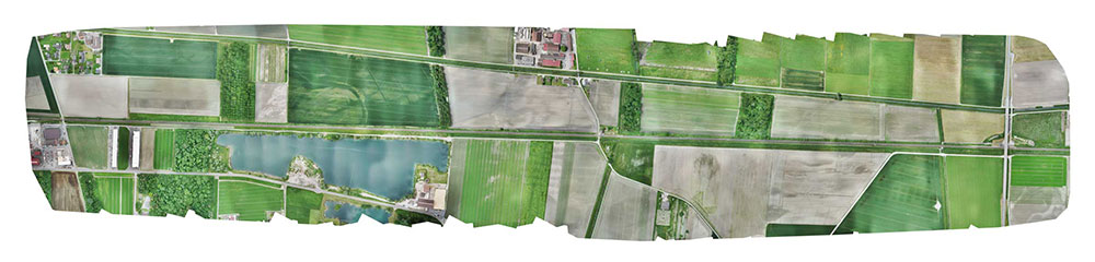
Final orthomosaic generated by the images collected by the WingtraOne: the 3-km long Eurotube will be constructed along the indicated area. (Image: Wingtra)
From aerial imagery to point cloud
Infographic: Wingtra
After two flights, the images were pre-processed with WingtraHub, a desktop app, to add geographical identification metadata to the images. PPK processing was also done in this step. The base file for PPK processing was obtained from Swisstopo, which monitors GNSS receivers at 30 permanent locations in Switzerland. These receivers form the modern-day reference points for positioning and surveying, and help enhance the geolocation information of the images in conjunction with the flight data (hence the name, post-processed kinematics). It took a little more than half an hour to pre-process the entire dataset.
The images with their accurate geolocation information were then uploaded to Pix4Dmapper to generate a point cloud of the site. All in all, it took less than 24 hours to go from data collection to point-cloud generation, without compromising on the quality of survey itself.
“We are pleased to say that the dataset gathered by the WingtraOne was precise enough to let the engineering office begin planning construction,” Mark said. “The generated point cloud has a vertical accuracy of 10 centimeters and horizontal accuracy of 3 centimeters. Thanks to the WingtraOne, we are now well on track on our timeline to begin construction.”
According to EuroTube’s scheduled timeline, a shorter prototype of the tube will be completed at the end of this year, and an alpha tube at the end of 2019. European research and development teams across institutes and universities can then start testing pod technologies to make ultra-high speed transportation systems a reality.
Adyasha Dash works as a software developer at Wingtra, where she focuses on developing safe flight control and planning algorithms. When she is not tinkering with drones, you can find her writing about the ethics of artificial intelligence and human machine interactions.
Wingtra’s Stephanie Lambert discusses the company’s WingtraOne drone at Intergeo 2017, which took place Sept. 26-28 in Berlin, Germany. According to the company, the WingtraOne simplifies mapping and surveying through easy and smart aerial data collection.