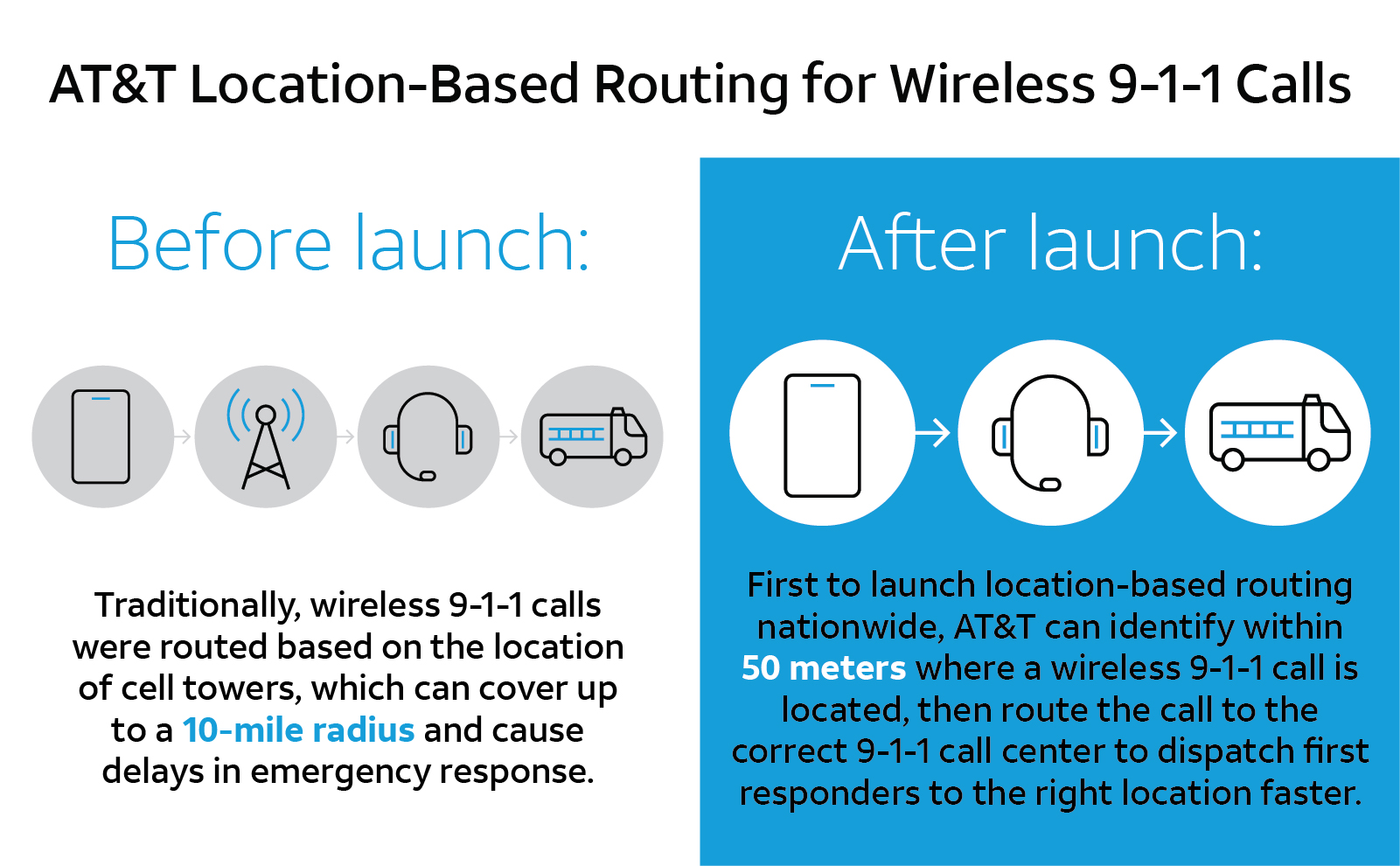
U.S. cellular carrier AT&T is rolling out location-based routing to automatically transmit wireless 9-1-1 calls to the appropriate call centers.
Traditionally, wireless 9-1-1 calls were routed based on the location of cell towers, which can cover up to a 10-mile radius. This can cause delays in emergency response, especially when a call is made where state, county or city boundaries overlap.
With location-based routing, a device can be located and routed within 50 meters of the device location. Through a new “Locate Before Route” feature from Intrado, AT&T can quickly and more accurately identify where a wireless 9-1-1 call is coming from using device GNSS and hybrid information to route the call to the correct 9-1-1 call center.
Graphic: 911
The nationwide rollout has started and is available in Alaska, Colorado, Hawaii, Idaho, Montana, Oregon, Washington, Wyoming, Kansas, Illinois, Iowa, Minnesota, North Dakota, Missouri, Nebraska, South Dakota and Guam. Additional regions will be rolled out over the next several weeks. The nationwide rollout is scheduled to be completed by the end of June.
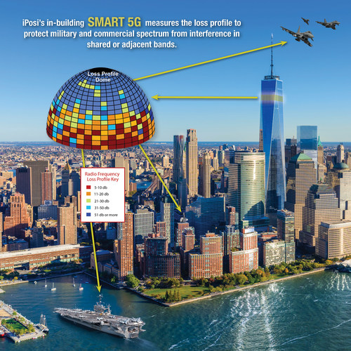
iPosi’s in-building SMART 5G measures the loss profile to protect military and commercial spectrum from interference in shared or adjacent bands. (Image: iPosi)
The Defense Spectrum Office (DSO) of the U.S. Department of Defense (DOD) has contracted iPosi Inc. and Virginia Tech Applied Research Corporation (VT-ARC) to develop a GPS/GNSS system to measure radio frequency path loss that substantially increases shared spectrum without interference.
The contract addresses the need for increased shared spectrum between DOD and wireless providers who require expanded access because of skyrocketing demand for broadband 5G spectrum.
The iPosi loss-profile technology automates measurements of GPS/GNSS controlled satellite signal transmissions. Once compiled, these form precise intelligent arrays ultimately characterized as an intensity-based 3D loss-contour map.
As satellites move across the sky, their signals illuminate radio path obstructions precisely. The 3D map is specific to each site sharing the channel. Each loss-map determines the extent of shared channel radio isolation with a low-error loss between wireless entities, and continuously updates to maintain interference-free channels.
Though applied initially to sharing DOD ground-to-air systems with commercial wireless services, the technology has wide applications for other 5G services, iPosi said.
“This relationship is an important foundation for DoD and commercial applications of our technology across a wide range of spectrum sharing initiatives,” said Richard Lee, CEO of iPosi. “We look forward to collaborating with our partners to enable greater spectrum sharing.”
The agreement represents a collaboration among multiple academic and industry partners, one of several endeavors by the Defense Information Systems Agency and Defense Spectrum Organization under the Spectrum Sharing Test & Evaluation (SSTD) project as part of the DOD Advanced Wireless Systems–3 (AWS-3) spectrum transition program.
The iPosi/VT-ARC technology would enable a substantial increase in protected, interference-free wireless service that operates in DoD or federal government bands. Once scaled, it could also support broader civilian and federal shared spectrum operations essential to both spectrum protection and growth of 5G.
Lee cites iPosi’s three-year relationship with VT-ARC and DISA/DSO as an important foundation for commercial and government applications of iPosi’s GPS-based loss-profiling technology. The earlier collaboration led to field validation of new tomographic wireless propagation measurements that enable sharing between new 5G and DOD in common 1-10 GHz mid-band spectrum blocks.
The next generation of mobile network architectures promises increasing speeds and lower latency for the ever-expanding base of users and the constantly growing data volumes transmitted.
In order to deploy this next generation (5G), the network must be densified. Densification implies more cell sites in more locations and getting the signal closer to the users. This in turn places more stringent requirements on network synchronization to achieve these goals.
Network time and phase synchronization below 100 ns accuracy is critical for the low-latency requirements of 5G networks. As wireless carriers gear up for deployment, new digital GPS repeaters can ensure wireless networks are 5G-ready.
A free webinar this Thursday, Sept. 6, will review different methods of achieving frequency, phase and time synchronization in advanced communication networks, including 5G commercial wireless applications. Join two technical experts as they discuss the requirements for 4G and 5G network synchronization, the role of GPS/GNSS signals in synchronization and the different types of synch architectures.