Landscape of Badwater Basin salt flats, with halite textures under a vibrant pink sky during sunset or sunrise at Death Valley National Park. (Photo: StephenBridger / iStock / Getty Images Plus / Getty Images)
The U.S. Geological Survey (USGS) has commissioned Woolpert to collect Quality Level 1 lidar data and conduct ground control surveys throughout Southern California in support of the 3D Elevation Program (3DEP) and The National Map.
Overseen by the USGS National Geospatial Program, 3DEP provides the nation’s first comprehensive, high-resolution topographic elevation data integrated into The National Map. The data will be accessible to local, state and national agencies to consider when making decisions that affect the immediate safety of life, property and the environment, as well as for long-term infrastructure planning.
Woolpert will collect roughly 60,000 km2 of aerial lidar data throughout Inyo County, California, including parts of the Mojave Desert and Death Valley National Park, using a Leica TerrainMapper. QL1 data are collected at eight points per square meter.
“Woolpert has had the honor of supporting USGS’ 3D Elevation Program since its launch nearly a decade ago,” said John Gerhard, Woolpert vice president and program director. “Critical decisions that depend on accurate and available elevation data are being made every day, and we are incredibly proud to continue our support for the U.S. Geological Survey and its commitment to completing the nation’s first-ever baseline of consistent high-resolution elevation data.”
Gerhard added that the data acquired for this project will also support the USGS 3D Hydrography Program (3DHP). The project is underway, and data is expected to be acquired by fall 2024.
Woolpert has received the 2019 Google Cloud Specialization Partner of the Year award for location-based services.
Woolpert was recognized for the company’s achievements in the Google Cloud ecosystem, helping joint customers deploy and optimize their location-based services, developing an online customer assistance system and cloud information portal, more than doubling its staff to support customer needs and supporting all location-based data efforts with its extended geospatial team.
The firm, which has been a Google Cloud Partner since 2015, was awarded this honor and the Google Cloud Partner Award for Customer Success in Google Maps Platform in 2018. Woolpert Vice President and Chief Innovation Officer Jon Downey said Woolpert is honored to work with Google Cloud and provide a heightened level of products and services to the teams’ joint customers.
“We thought this would be a natural partnership, joining the world leader in customer-facing location-based services with one of the first global geospatial mapping firms, but it has far exceeded our expectations,” Downey said. “It has given us the ability to create products and provide support specific to our clients’ location-based needs, which has led to a greater than 98% retention rate and more than 100 additional customers in 2019. We look forward to what this partnership will yield in the future.”
“We’re proud to recognize Woolpert’s work on behalf of customers,” said Carolee Gearhart, vice president, Worldwide Channel Sales at Google Cloud. “Woolpert has demonstrated strong expertise and results in providing location-based services for customers over the past year, and we look forward to continuing our partnership to help customers succeed.”
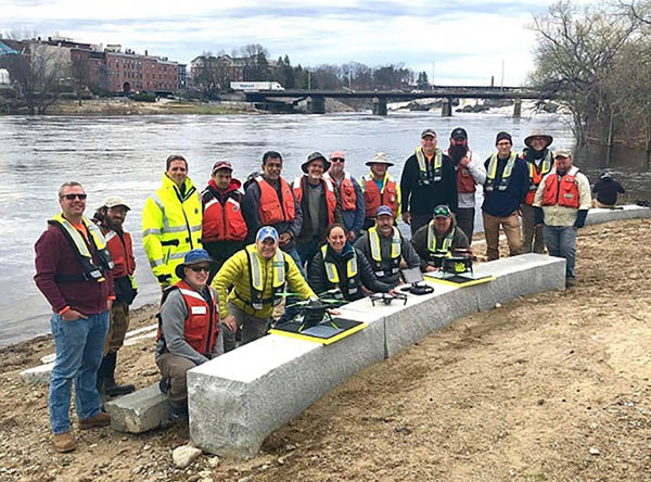
2019 Aquatic Airshow participants at Androscoggin River in Auburn, Maine, on May 1. (Photo: Mario Martin-Alciati, USGS)
The U.S. Geological Survey (USGS) and independent scientists gathered this month in Auburn, Maine, to evaluate the use of sensor-mounted unmanned aircraft systems (UAS) to gauge stream stage, velocity, bathymetry and discharge.
The technology is being evaluated and modeled to determine whether it will support the fast, accurate and safe measurement of rivers, especially when they are flooded or contain floating trees, ice or other debris.
Close to two dozen hydrologic, geospatial and scientific experts gathered in what has been dubbed the “2019 Aquatic Airshow” to assess the technology. They were led by John Fulton of the USGS Colorado Water Science Center, Jack Eggleston of the USGS Water Mission Area Hydrologic Remote Sensing Branch, and Joe Adams and Sandy Brosnahan of the USGS National UAS Project Office.
The USGS Water Mission Area works with partners to monitor, assess, research and report on a wide range of water resources and conditions, including streamflow, groundwater, water quality, water use and water availability.
The testing involved equipping drones with noncontact sensors, including ground-penetrating radar for measuring river depths, doppler velocity radar and cameras with velocimetric analysis for measuring water surface velocities and calculating mean-channel velocities; and high-resolution cameras for photogrammetric mapping of surface topography and vegetation structure.
All the evaluated sensors were equipped with GNSS receivers; some with RTK correction capability. Most of the drones used were equipped with a low-grade inertial measurement units (IMUs) for navigation.
Team members from the USGS Water Science Centers in Colorado, New England and Virginia collected ground-truth river monitoring data with acoustic doppler current profilers deployed from a boat and multiple other surveying techniques to verify the accuracy of the drone-based stream data.
Woolpert Chief Scientist Qassim Abdullah was one of two scientists from the private sector asked to participate in the airshow. Abdullah has more than 40 years of experience in analytical photogrammetry, digital remote sensing, and civil and surveying engineering.
For the event, Abdullah devised a process in which the data collected by the drones underwent Pix4D triangular adjustment to produce three-dimensional models of the water surface and river edges to assist the modeling of river velocity using the drone-based doppler velocity radar and large-scale particle image velocimetry.
USGS scientists are in the process of evaluating the data and modeling produced by this testing to conclude whether this technology will prove beneficial.
Abdullah said the airshow was a success due to the varied contributions from each member of the team, their diverse backgrounds and their shared focus on water research.
“This was a great example of how a public-private partnership can work together to activate and elevate necessary, groundbreaking technologies to address worldwide issues,” Abdullah said. “Airshow team members brought different perspectives, processes and applications to the testing, which not only proved essential for this project but will help with many others moving forward. I love working with this group and look forward to continuing to help advance these vital technologies.
Woolpert has signed a five-year, multimillion-dollar Geospatial Product and Services Contract 3 (GPSC 3) with the U.S. Geological Survey (USGS) to provide mapping and surveying services.
The GPSC is a suite of contracts used by federal, state and municipal government entities to partner with USGS for the purpose of fulfilling their geospatial data requirements.
The contract will be administered through the National Geospatial Technical Operations Center (NGTOC) in an effort to obtain geospatial data services throughout the United States and its territories. The contract also will be used to support the 3D Elevation Program (3DEP) and used by other federal, state and local agencies.
“This provides Woolpert with the opportunity to continue working with USGS on their 3D Elevation Program (3DEP), an eight-year program to provide highly accurate 3D elevation data of the entire U.S.,” said John Gerhard, Woolpert project director. “This data will be collected via lidar (light detection and ranging) to create the most accurate surface model, and will be used to evaluate flood risk and natural resources, support FEMA, help farmers with precision agriculture, assess and manage infrastructure, and much more.”
Jeff Lovin, Woolpert senior vice president and director of government solutions, said the Woolpert staff is proud to have had the opportunity to work with the USGS for nearly 25 years. “Over those 25 years, we’ve had the opportunity to collaborate on different layers of the National Spatial Data Infrastructure (NSDI), from the development of nationwide imagery in the 1990s to 3D elevation and hydrography today,” Lovin said.”It’s very gratifying to have the opportunity to play a part in such an important program for our nation.”
From (L to R) John Palatiello, MAPPS executive Director; Jim Green; Mike Sitar and Michel Stanier of Optech Teledyne.
Teledyne Optech‘s ALTM Titan lidar sensor earned the 2015 Grand Award in the ninth annual MAPPS Geospatial Products and Services Excellence Awards, MAPPS recently announced in a news release. The awards ceremony was held Feb. 2 at the Green Valley Ranch in Henderson, Nev.
Teledyne was also presented with an award in the Technology Innovation category.
The company said in a news release that Titan is easy to handle in complex scenarios, such as acquiring three wavelengths simultaneously; incorporating a metric camera imbedded in the system; creating a sensor that fits in a 16-inch gyro-stabilized mount; and increasing the depth penetration of the bathymetric sensor. To achieve this, Vaughan, Ontario-based Teledyne Optech had to develop new fiber lasers and a triple wavelength receiver which allowed for the collection of bathymetric lidar, topographic lidar and multispectral lidar in one single sensor.
“Teledyne Optech’s ALTM Titan is a marvel in lidar engineering,” said Robert Burtch PS, CP, professor emeritus at Ferris State University in Big Rapids, Mich., and chairman of the panel of judges. “This development allows the collection of bathymetric lidar, topographic lidar and multispectral lidar in one single sensor.”
The MAPPS awards competition recognizes the professionalism, value, integrity and achievement that member firms have demonstrated in their projects and technology developments over the previous year.
MAPPS also honored winners in six technical categories.
Woolpert of Dayton, Ohio, was selected in the Photogrammetry/Elevation Data Generation category with the Little Bighorn Battlefield National Monument Headstone Mapping Project that utilized lidar to locate and map 4,320 headstones and 280 battlefield markers.
The winning project in the Remote Sensing category was by Aerial Services Inc. of Cedar Falls, Iowa, for The Race for Now: Maximizing Crop Yields Using Innovations in Remote Sensing project, which acquired imagery using multiple sensors during the critical growing phases to produce a web-based precision agriculture service in the State of Iowa.
In the GIS/IT category, Merrick & Company of Greenwood Village, Colo., was selected for GIS Models Visualize Ancient Flooding Problems in the country of Columbia. As project manager, Merrick provided technology transfer and GIS data and training, and introduced a new methodology, “monotonicity,” which guarantees that acoustic bathymetry, lidar and breaklines are correctly integrated.
The winner in the Surveying/Field Data Collection category was the Baltimore, Md., office of AECOM for its Protocol for Determining Grass Channel Credits project. Using GIS, lidar and aerial imagery, AECOM worked with the Maryland State Highway Administration to identify roadway ditches to assure compliance with the Department of the Environment grass channel treatment criteria.
TerraSond of Palmer, Ark., earned the award in the Small Projects category for the Bradley Lake Hydro Power project. TerraSond teamed to perform an inspection of a diversion tunnel to a dam and power tunnel inlet in Homer, Alaska to identify the quantity of debris that was covering the inlet screen by comparing the debris profile with the as-built drawings to determine the amount of debris that needed to be removed.
Titan, Teledyne Optech’s multi-spectral lidar sensor, also won in the Technology Innovation category.
A panel of independent judges evaluated projects submitted by MAPPS members for the awards program.
The Japan District of the U.S. Army Corps of Engineers has awarded the Woolpert-KZF Joint Venture (W-KZF JV) three task orders totaling approximately $6.95 million to support the design of a $150 million CV-22 complex at Yokota Air Base in Fussa, Japan.
The facilities, which will support the bed-down of CV-22 Osprey aircraft at the base, include an aircraft maintenance hangar, a squadron operations building, an MRSP warehouse, a flight simulator facility and a headquarters building.
W-KZF JV is working closely with Jacobs Engineering of California. Jacobs is providing design services in support of the horizontal infrastructure improvements for the CV-22 campus development.
Woolpert is a national architecture, engineering and geospatial firm headquartered in Dayton, and KZF Design is an architecture, engineering, planning and interior design firm based in Cincinnati. The Ohio firms’ joint venture also was selected this summer to provide full design and construction services for the schools serving U.S. military families in Japan.
Jacobs, headquartered in Pasadena, is a large and diverse providers of technical, professional and construction services.
Project Manager Rebecca Knolle said Woolpert has been working on the CV-22 campus development plan with Air Force Special Operations Command (AFSOC) since 2013.
“We’ve been with this endeavor from the outset,” Knolle said. “What’s novel about this project is that it will require the W-KZF JV and Jacobs teams to work collaboratively. We see this as a good opportunity for knowledge sharing.”
Construction is expected to begin on the complex in 2017 and will be completed in 2020-21.
The U.S. Geological Survey (USGS) has contracted with Woolpert to evaluate new lidar (light detection and ranging) technologies to assess the suitability to support the 3D Elevation Program (3DEP).
This use of the single photon and Geiger mode lidar for this evaluation is new to the commercial market, according to Woolpert Project Director John Gerhard.
“This technology provides the ability to fly at higher altitudes while acquiring data at an increased point density,” Gerhard said. “The USGS has asked us to provide an evaluation of this sensor technology in support of 3DEP.”
The USGS is developing the 3DEP initiative to respond to the growing need for high-quality topographic data nationwide, to address issues that include flood-risk management, precision agriculture, natural resource management, infrastructure management and hazard mitigation.
Woolpert — a national architecture, engineering and geospatial firm — will then evaluate the data, conduct an accuracy analysis, develop final data products and provide a comprehensive report to the USGS by the end of the year.