Author: Don Jewell

  • Mobile Epiphany – Round Two

    Don Jewell
    Headshot: Don Jewell

    Many of you may remember my one and only software review of a product called Touch Inspect back in December 2009, by a Denver, Colorado (Aurora)-based company called Mobile Epiphany. At the time this is how I began my initial brief review of the software program:

    “The software is called Touch Inspect, and it is essentially a computerized, geospatially aware, data-collection application with an amazing user interface. But having said that, just so you understand the basic intent of the program, I have to also say that it is so much more than a computerized data-collection application. Calling Touch Inspect a typical computerized data-collection application is like comparing a skateboard to a Ferrari.”

    At the time I promised an in-depth review the software “real soon.” Well, real soon has turned into 16 months, and not a single week has gone by that I have not received several e-mails wanting to know more about the software and asking when the next review would be published. So for all of you who have been waiting, this is the promised in-depth review of Touch Inspect version 2.0, which the company now promotes as customizable software tools under the more apt heading of “Mobile Business Process Software.” But the base program is still known as Touch Inspect.

    Bottom Line Up Front — BLUF

    When you brief senior military officers today, as I have occasion to do, it seems that they all want the first chart to be the BLUF chart. It is a version of the old military briefing idiom that goes like this: Tell me what you are going to tell me and then tell me and then at the end tell me what you told me. So I will start by saying that my original assessment of Touch Inspect has not changed, unless it is to have become even more enamored with this incredible software. I have an even broader vision of its uses, especially for warfighters, whether their primary function is combat, maintenance, inspection or logistics. This software applies to first responders as well. You be the judge.

    Versatility and Visions

    When I was first briefed on this unique software program back in 2009, my first thoughts were that this is indeed a great inspection software program, but I can think of so many more uses for it. My first thought was that it would be wonderfully useful as a mobile IED (Improvised Explosive Device) database, inspection, and information-gathering program. In fact, it was so obvious that I was off wool-gathering about IED databases during the briefing that the CEO of Mobile Epiphany, Dr. Glenn Kletzky, stopped his presentation until I rejoined the real world. But this is what hearing about this incredible software does to you. It makes you think of all the possibilities and capabilities it makes available to our warfighters and first responders. I was happy to hear from Glenn that my reaction, thinking that Touch Inspect is so much more than a top-notch mobile inspection tool, was to become a commonplace reaction amongst almost everyone who saw or heard about the software.


    Today, Touch Inspect, running under numerous pseudonyms, is being utilized by our government and others in ways we just can’t discuss in this venue. It is being tested and/or used in the construction industry, in oil and gas operations and exploration, in utility related industries, in the telecommunications industry, in human services and tracking, as well as in healthcare, just to name a few of the myriad user communities. There are other users that I am not allowed to list because this software really gives you an unfair advantage over those not utilizing its considerable and unique capabilities. Suffice it to say that almost everyone who views a demonstration of this extremely flexible asset and process/procedure-focused software thinks of something useful for it to accomplish, and sometimes it even involves inspecting something.

    My first thoughts of using Touch Inspect for activities surrounding IEDs has evolved considerably. Not only can the Mobile Epiphany software be used to house an interactive mobile database with all the knowledge we have gained about IEDs, but when the software is running on a rugged mobile device with GPS, communications, and cameras, as well as other sensors, it enables the user to:

    • Take a picture of the device and annotate that image
    • Look up other items in the database with automatic prompting of what the user should look for
    • Instruct the user how to interact with the IED (other than the obvious precaution of ‘run’ or proceed very carefully)
    • Assist users in identifying the type of IED and the associated dangers
    • Automatically gather data such as location to include GPS or specific grid coordinates, altitude, and heading and whether other IEDs have been found on the same site previously or in the surrounding area and can automatically identify those locations on an internal or externally obtained map
    • Record the time of the observation and the position of the observer, for review at a later date.

    If the IED is a common type or one seen previously by EOD or Explosive Ordnance Disposal personnel, the software can be configured to instruct the user on disarming the device, if he/she is crazy enough to do that, and if disarming is indeed an option; it does all this with preprogrammed software that ensures all the necessary data is collected. If the user is a novice, which can be automatically determined by the user’s login and granted permissions, the software can automatically prompt the user at every step, or in the case of an experienced user, the software can make use of an accelerated or “fast-flow” mode that eliminates many of the more basic steps or procedures and gets to the required data collection and instructional screens without delay.

    In short, the software is flexible in the extreme, to the point that I can make the statement that I see uses for it every day, especially for our warfighters and first responders, and I sincerely hope that it makes its way into the .mil applications store for the DoD soon. It is a software product and capability/advantage our warfighters desperately need.

    Platforms

    When I wrote my first review, the Touch Inspect software (version 1.0) ran only on handheld devices that used the Windows Mobile Operating System. Today, it runs on all versions of Windows Mobile (5, 6, 6.1 and 6.5) as well as running on all versions of the full Windows operating systems (XP, Vista, and W7). Furthermore, the full Windows version of Touch Inspect runs on all PC-based slates and tablets in either orientation (portrait or landscape) and can be resized from full screen to a minimal window size, thus sharing the screen with other applications.

    Today the software is also in the process of being ported to Android and Apple platforms. The Android operating system versions will be released in the third quarter of 2011 and the Apple versions will be released in the fourth quarter of 2011.

    Although Mobile Epiphany is growing by leaps and bounds, according to Dr. Kletzky, I predict that the company will really take off when the Android and Apple versions hit the street. If you can’t tell, I am as excited about this software as I am about my iPad and
    iPhone because it will take the usability of these highly desired and much utilized mobile platforms, especially for warfighters and first responders, to new heights. The software and hardware combined will present an awesome potential that will greatly enhance our warfighters’ and first responders’ productivity and safety. For example, since these are the most popular and prevalently used devices in theater, the U.S. Army is considering a plan to provide Android and Apple mobile devices to the warfighters. So why not provide the warfighters with the very best and most flexible software, along with its very friendly user interface as well? Provide the warfighter with devices and software that they will actually use and customize to their needs. The combination of top-of-the-line mobile devices and Mobile Epiphany software will save time, money, and lives. But, of course, Windows is already in very wide use today throughout our armed forces, and this software is ready right now to help those existing users.

    I’m convinced the combination will prove to be an invaluable tool for mission planning, data collection, intelligence gathering, and post mission debriefs, as well as a tool for the everyday tasks that must be conducted in a prescribed manner — such tasks as pre-flights, repair procedures, facility and equipment inspections, and anything else that requires a complex procedure or checklist today. I don’t want to dumb down this versatile product and call it an automated and/or interactive checklist, because that is just one of the more mundane but important uses of the software. And I don’t want you to forget the instructional capability of the software. You can have complex procedures where every step is accompanied by multiple reference high-definition media to ensure success at your task, like a parts blow-out or a wiring diagram, right on your mobile device. Whether you need to learn a new complicated business process or a new series of military procedures, the Mobile Epiphany software has the ability to take you through it step-by-step flawlessly, with seemingly endless potential branches in any scenario, until you are confident that you have mastered your task. Glenn Kletzky explained it this way: “Once you have procedures or processes of any sort established, and you have users who perform and confirm those steps on paper or on screens, it is then just another small step to convert those steps, complete with branching logic based on a user’s input, into Touch Inspect.”

    “Although it is critical to ensure quality data collection and disciplined procedural adherence to process, it is also a step ignored by most software programs,” Kletzky said. “Once these steps are rapidly configured into the Touch Inspect’s Business Process design tool in combination with the available branching logic capabilities, viola! you have a process that can be customized to the user’s needs.”

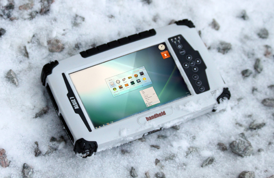
    The Algiz 7 running Touch Inspect.


    The Real Deal

    Never being one to totally trust marketing hype, I showed up at Mobile Epiphany’s facility a few weeks ago with three very different GPS-enabled mobile computers. I brought the latest Trimble NOMAD, being used by thousands of our warfighters today, a borrowed first-generation GD (General Dynamics) rugged MR-1 computer, which I reviewed for our readers two years ago in April 2009, and the most recent computer I reviewed, just last month in fact, the Handheld Algiz 7. I then challenged Glenn to load version 2.0 of the Touch Inspect software on all three machines and we would see how they fared.

    So while Glenn was giving me the latest updated briefing on and future plans for the Mobile Epiphany software, his technicians loaded the software and the results were amazing. The rugged GD computer was the oldest machine, being a very early version (Hint: there is a much more modern and totally waterproof version of the MR-1 available today from GD). My borrowed device is several years old and still operating with an antiquated version of the Microsoft XP operating system, with a small amount of RAM, compared to today’s latest machines. But once loaded, the Mobile Epiphany software screamed on the machine. Everything from zooming in on annotated images, slipping and zooming in on maps, rolling through flick lists of assets, etc., all animated smoothly. It ran as fast, once loaded, as the two newer machines, which sported much faster processors and double or triple the RAM. This just goes to prove that the software does adapt well to various platforms and operating systems. You don’t need to have the latest and greatest hardware and tons of RAM to run this software. That to me is a testament to the hard work the Mobile Epiphany software engineers have put into making this a truly adaptable mobile software tool, that really comes alive on a PNT-enabled device.


    The GD MR-1 running Touch Inspect.


    Adaptability

    For those of you who are saying, yeah, great, sure it is customizable, but I don’t have millions of dollars and months or years to customize the Touch Inspect software to make it do what I need it to do. Oh contraire, mon ami. On-the-fly process and workflow customization is another major strong suit of this software, and it differentiates it from any other software I have ever used.

    Dr. Glenn Kletzky is actually the CEO of two very successful IT companies, Mobile Epiphany and iBeta. iBeta is a 12-year-old software quality assurance and testing laboratory for software ranging from enterprise class applications for government all the way to the video game industry. And he and his team have been at this for some time, and they have experienced the agony of the software development life-cycle (SDLC). It is not uncommon for robust mobile applications which include geospatial and process capabilities to require no less than 18 months to design, develop, test, and fix prior to being ready for deployment. Additionally, the SDLC requires a team of skilled programmers and testers to meet those deadlines. And even that speed can only be achieved using tools known as Rapid Application Development or RAD tools. Glenn likes to say, we (Mobile Epiphany) took that process from 18 months to 18 hours, and the 18 hours requires no software developers. All that is required is a subject matter expert (SME) in the field for which you are customizing the software and a single person who knows how to configure the process using the technology’s easy-to-use configuration toolset. Yes, you heard me right: just 18 hours versus 18 months. Talk about time, cost savings, and flexibility.

    Mobile Epiphany accomplishes this feat through a process known as Rapid Application Configuration or RAC, and it is possible because of Mobile Epiphany’s new approach to rapid application creation and deployment. You do not have to go through the traditional lengthy process of designing the application itself and the screen appearances, or even the work flows. This is because the application and all the relevant workflows required for a geospatial, process-based application already exists. The software has already been designed, developed, and tested. The person in charge of configuration simply “configures” the application (easy to learn — no programming at all) with a rapid customization tool included in the
    configuration tool set, known as the “Business Process Designer.” And this configuration tool, along with others, can be learned by non-programmers in a matter of a few hours. This means our warfighters, who already customize and download specialized applications on their non-government mobile devices, can now totally customize Touch Inspect software via the RAC process, on the fly, in the field, in less than a day, to do exactly what they need it to do. And after one person configures the work flow or process required, it can be sent wirelessly or by wire to two or two thousands other users. I know this sounds impossible and too good to be true, but I have personally observed the process and then customized the software myself, and believe me if I can do it, anyone can. And the beauty is that the customization process and version control are seamless. They appear to the user to just be another part of the application because they are, and that is a large part of the appeal of the Mobile Epiphany software.

    What makes Mobile Epiphany Software So Different?

    When I asked Glenn how he had managed to develop software with such incredible and user-friendly capabilities, he simply said: “We listened to our customers and our users, and we figured out a way to simplify the process of giving them what they need. They asked for powerful and flexible software with a friendly user interface that could be customized in the field, on the fly and that’s what we gave them.” It should be noted that Glenn worked with video-game designers in his company, who are not programmers, to develop the entire interface.

    Now- anyone in the software business knows that in order for a powerful software program to accomplish useful work and still be simple to operate, there must be a tremendous amount of capability hidden inside an intuitive interface with a definable hierarchical process and this is what Mobile Epiphany software epitomizes.

    So indeed Mobile Epiphany has built a very useful business process software tool that incorporates:

    • Robust hierarchical lists with image and data lookup built-in. After all, images can be a big part of the procedural discipline and data collection and process.
    • A powerful and advanced branching logic engine: think Boolean logic and powerful and/or <> = rules and searches made easy.
    • Using math as a method to determine branching logic requirements, and making math easy and natural for the user.
    • Ensuring there is a hierarchical approach to everything (if you require it) with drill downs at every level to ensure you won’t get lost in the process.

    To add authenticity, intended use specificity, and ownership for the user, Mobile Epiphany spent hundreds of programming hours making it easy for the user to “skin” or customize his own application’s appearance. It is all Touch Inspect underneath, but it can make the interface appear to be user purpose specific, with art placed onto the interface not only as a user trademark, but also as an integral part of the buttons they press to complete their unique workflow and process. Indeed, with the Mobile Epiphany software, customer branding can be displayed in many ways, obvious or subtle, on every screen if necessary, and it can all be accomplished within the confines of the original software. As the saying goes today, there is a GUI (graphical user interface) and/or an app for that, and in this case they are built-in.

    For example, if a fire department is using the software, the program displays an almost endless variation of maps and/or floor plans plus a database of chemicals that have toxic fumes when exposed to heat. Both maps and encrypted data can be stored directly on the device (no network connection required in order to keep working) or it can be brought in through secured online connections (real-time) to map and data servers. The software readily accommodates PNT (position, navigation and timing) inputs, as well as geospatial information system data, from numerous sources, and seamlessly incorporates those inputs and displays the information as needed by the user, in more ways than you would imagine. The system’s server even has a complete set of web services and APIs (application programming interfaces) so that the data trapped in legacy systems and only accessible through fixed terminals can now be made mobile through integration to the Mobile Epiphany servers.

    If you want or need more diversity, then rapid customization on the fly is only a few hours away. You don’t need a separate development team or costly software development program. All the customization capabilities are built into the Mobile Epiphany software, and you can test the results of your changes as you go along. Remember, all that’s required are the subject-matter experts who have a process that needs to be made mobile. The software also features a powerful report-building and report-running tool, a business process design tool for rapid application configuration (RAC), an enterprise description and security administration tool so that you can decide who in the organization (or what group of people) can gain access to which data, as well as a data exploration tool for rapid look-up of data via an easy-to-use query engine.

    Reports

    All the customization and rapid configuration tools and capabilities sound great, but what about the reporting tools? What happens when you need to interface with the office IBM mainframe or a distributed military server network and then need to print or produce reports in a standard format with legacy reporting requirements? Not a problem; the Mobile Epiphany software can integrate to any legacy system on the company server or network seamlessly and produce reports in most all required formats.

    There are web services and APIs (application programming interface), which allow the software to be integrated to any other existing system or network. It is a combination push-and-pull process. While the software does not need any other back-end system to function (it is a full, end-to-end system), it can also function as powerful middleware for existing systems. The way Touch Inspect collects data and tracking geospatial metadata, it retains a rich layer of metadata on the assets and users in the system (as well as images and signatures that are also date, time, and geotagged) that most systems may not be designed to store and report on. Therefore, the integration of data from a legacy system into the Mobile Epiphany servers acts not only to mobilize the data, but to extend the capability of the legacy system, storing the geospatial metadata and other aspects of data that the legacy system was not designed to retain.

    Integration to other systems is certainly not a requirement to make use of the software. As stated previously, it is a full stand-alone, end-to-end system. But the Mobile Epiphany software works in such a unique way that customers can take advantage of the capability until their systems can be modified to store and forward the encrypted data as needed. Although Mobile Epiphany hosts their clients’ data in their servers in the cloud, the server technology need not be hosted by Mobile Epiphany. The Mobile Epiphany server technology is also available to customers who want to host and secure their own data behind their own firewalls. Like the new IBM commercial says, “We have to start thinking about data differently,” and once you experience the amount of rich metadata that the Touch Inspect software produces, you will understand why this is a popular capability.


    Bottom Line at the End – BLATE

    The Mobile Epiphany software is a valuable tool that our warfighters and fir
    st responders need to have in their arsenal now. The software by itself is a revelation, and when combined with real-time GPS data, it becomes a true force multiplier. The Mobile Epiphany software provides the warfighter and first responder with a capability that, once used, they will not want to be without.

    The Mobile Epiphany software is so easy to use and customize, and the user interface is so intuitive, that users are typically up and running and customizing the software in a matter of hours. When contrasted with the horrible user interface and proprietary software on the current MGUE (Mobile Government User Equipment) issued today, the Mobile Epiphany software is a simple no-brainer. Let’s make sure we provide our warfighters and first responders with the latest and greatest software and most friendly user interface available today; in my opinion, that is software from Mobile Epiphany. I will go so far as to say that if the current version of the handheld DAGR (Defense Advanced GPS Receiver) were running Mobile Epiphany software, it would be a valuable tool that warfighters would actually enjoy using, despite all its other shortcomings. I can say this because reportedly all the embedded DAGRs that are currently in use perform their tasks well, as long as the user does not actually have to interface directly with the device. What our warfighters actually say about the current DAGR user interface and operating system, we can’t print. But you can imagine. So it’s nice to know there could be a fix. Now I just need to get Rockwell Collins and Mobile Epiphany in the same room.

    But, hey. You don’t have to take my word for it. Just go to the Mobile Epiphany website and view the numerous video demos and tutorials. Or call the company and request a test drive. I am convinced you will agree with my assessment. Please click on the e-mail address below, and then drop us a line and let us know what you think at[email protected].

    This week (11-15 April 2011) I will be attending the 27th Annual National Space Symposium, the largest space symposium and exhibit in the world today, in Colorado Springs, Colorado, at the beautiful Broadmoor Resort. Tough duty, but somehow I will prevail. Be sure and check the GPS World website for my daily blogs, as I am sure the LightSquared debacle will be a focal point of many discussions. (For a list of all GPS World blogs, click here.)

    Until next time, happy navigating.


  • A Look at the Rugged Handheld Algiz 7

    The warfighters have spoken. My correspondence lately has been full of questions about tablet and handheld computers. My sources at AT&T and Verizon tell me that the number of iPads in Iraq and Afghanistan have doubled in the last year alone. The problem is that Apple iPads and iPhones, for all their ubiquity, are not rugged in any sense of the word. Enter Handheld US with the Algiz 7.

    Algiz-7-on-snowy-ground-W

    The warfighters have spoken. My correspondence lately has been full of questions about tablet and handheld computers. Out of every 10 letters or emails, seven contain comments or questions about tablet type or handheld computers.

    Ever since the Apple iPad came bursting onto the portable computer scene, everyone else has been trying to produce a competitor. Now that the iPad 2 has bowed, everyone is once again behind the eight ball and struggling to catch up.

    My sources at AT&T and Verizon tell me that the number of iPads in Iraq and Afghanistan have doubled in the last year alone. Skype calls are the most frequent way our warfighters stay in touch with their loved ones. Viewing those you care about on a high-definition 10-inch color screen beats a MARS call any day!

    The problem, of course, is that Apple iPads and iPhones for all their ubiquity are not rugged in any sense of the word. You can make them more rugged with the excellent line of Otterbox cases I have reviewed in the past, but the fact remains that the iPad and iPhone are still not built from the ground up to be a rugged computing device, no matter how badly we think we treat them in our day-to-day work and commuting environment.

    The Swedes at the Gates

    Enter Handheld US, an affiliate of Handheld Group AB, a Swedish firm located in Lidkoping, which is a thriving metropolis of about 30,000 hardy inhabitants. Not surprisingly Handheld Group AB and Handheld US specialize in rugged handheld computers, like the Algiz 7, that are designed and built from the ground up for the rugged outdoors, for first responders, and for the military war zone environment.

    ROE – Rules of Engagement

    As many of my regular readers know, I review rugged military-compatible handheld computers on a regular basis. As with all the rugged computers I review, I put them through a series of torture tests. The ones that fail you never hear about, because I have a policy of never writing a bad review. Why should I waste my time and yours? After all, we both want to know about products that work as advertised, right? I know I do and be assured, BLUF, bottom line up front, the Algiz 7 lives up to its reputation as a rugged handheld or tablet computer that from all reports functions well in rugged military theaters such as Iraq and Afghanistan.

    Warfighters

    Several of our warfighters are currently using the Algiz 7 as well as many of the other Handheld US derivatives, many of them from companies such as Trimble that are repackaged and resold by Handheld US. To date it has been my experience that as a first responder or warfighter you cannot go wrong with any of the rugged Handheld US computers I have had the pleasure to review.

    Torture Tests

    As far as my torture tests are concerned, they usually involve lots of water, snow banks, and freezing temperatures, with some mud and ice thrown in for good measure, along with a few drops from several feet onto hard frozen ground. When I looked up Handheld Group AB and found their location in Sweden, it immediately became clear that the Handheld Group AB folks can test their computers the way I do almost any day of the week for a large portion of the year, just by stepping out their front door. Even so, I assiduously ran the Algiz 7 through all the torture tests and it survived admirably. Plus unlike many of the nearly sea-level tests in Sweden, my tests are performed at about 7,000 feet above sea level or higher, more closely resembling the altitudes in parts of Afghanistan.

    Specifications

    The word Algiz can mean many things, but is usually translated as “elk,” and that is a rugged animal. I see them occasionally in my backyard and they certainly survive in some rugged environments in the Rocky Mountains, so the name is fitting. The Algiz 7 certainly sounds better than the Elk 7.

    The Algiz 7 is a rugged handheld Windows 7 computer with integrated GPS capability perfect for today’s warfighters in many respects.

    We have been batting the word “rugged” around for some time, and now might be a good time to define exactly what rugged means. I have told you about my unofficial tests that are based on some of the MilSpec (military specifications) standards and their readily available definitions. However, it is interesting to see how Handheld defines rugged. Handheld defines rugged in its literature as pertaining to environmental specifications, of which the three most common and useful are:

    • Temperature range,
    • MIL-STD-810F/G
    • IP

    Fortunately for users, these specifications are almost always prominently listed on the product data sheet, but what the heck do they really mean? How do they translate into real-world requirements, especially in battlefield conditions?

    The temperature specification defines the operational temperature range of the unit. Working with a unit above or below this specification may well cause the unit to fail when you need it most.

    I have defined MIL-STD-810F/G several times in the past, but for all the first-timers, it is a standard issued by the United States Army’s Developmental Test Command. The standard consists of a series of various environmental tests to prove that equipment qualified to the standard will survive in the field. The MIL-STDs (military standards) were originally designed specifically to test military equipment, but are now used to test a wide range of both military and civilian products, including mobile computers with GPS capabilities.

    Certainly the letters IP stand for many things in our high-tech world today, but here it stands for Ingress Protection, and an IP rating is used to specify the level of environmental protection of electrical equipment against solids and liquids. In other words, it tells us what amount of a certain size of solids or liquids can get inside the Algiz 7 enclosure and possibly damage the device. For those of you who must know, it is defined by international standard IEC 60529.

    The MIL-STD Testing Methods

    If you look it up, you will find that MIL-STD-810F/G comprises about 24 laboratory test methods that cover a wide range of environments, from the ability to perform at high altitude (method 500.4 and one I know well) to the ability to survive ballistic shock (method 522). No mobile computer has ever, to my knowledge, been tested to all 24 methods; many of the tests just do not apply to mobile computing, but generally speaking, the more methods tested (and passed), the more rugged the unit.

    The most rugged handheld GPS/computer devices (like the Handheld Nautiz X7, which I reviewed in GPS World in April 2010) have been tested on average to between 8 and 10 MIL-STD-810F methods. So when you are evaluating a data or specification sheet, pay close attention to the testing methods that apply to your specific situation. If you are a warfighter in Afghanistan and will be routinely working near or over 10,000 feet of elevation, make sure the unit has been tested to the MIL-STD method that covers that altitude.
    If you are going to be working in rapidly changing temperatures, make sure the unit has been tested for temperature extremes and temperature shock. Several of the units I have tested and you have not read about, in one of my columns at least, failed both the temperature and thermal shock tests.

    The IP Definitions: What Level Do You Need?

    IP ratings are routinely displayed as a two-digit number. The first digit reflects the level of protection against dust (think Afghanistan and Iraq). The second digit reflects the level of protection against liquids, most frequently water or snow (think the mountains of Afghanistan).

    Technically speaking, the dust specification has seven different levels, level 0 to level 6, and the water specification has nine different levels, level 0 to level 8. But practically speaking, rugged computers all must have at least a dust protection level of 5 and water protection level of at least 4 or they are simply not rugged in my book. Beware, because there are some computers that list themselves as being rugged that do not meet these minimum IP specifications. I, for one, would be wary of them in adverse environments. Be warned: At the operational ends of the scale, the IP levels can make a huge difference in a device’s ability to operate in severe environments and to a device’s overall longevity. For example, a dust level of 5 means that some dust may get into the device, whereas a level 6 device is completely sealed and dust proof.

    For example, an IP65-rated device, such as the Algiz 7, is totally dust proof and is capable of surviving rain showers and dust storms, but not total immersion in water. This device would be an excellent choice in either a very dusty or dirty environment or one where it may be possible to drop the unit in the occasional snow bank. Currently both AORs (areas of responsibility) for our warfighters come to mind. For more complete IP definitions see the Handheld-provided list below:

    Ingress Protection
    First digit = protection against dust:
    0: No protection
    1: Protection against solids up to 50 mm
    2: Protection against solids up to 12 mm
    3: Protection against solids up to 2.5 mm
    4: Protection against solids up to 1 mm
    5: Protection against dust; limited ingress
    6: Totally protected against dust

    Second digit = protection against water:
    0: No protection
    1: Protected against dripping water
    2: Protected against dripping water (tilted)
    3: Protected against water spray
    4: Protected against splashing water
    5: Protected against water jets
    6: Protected against a nozzle under pressure
    7: Protected against immersion (1 meter for 30 min)
    8: Protected against submersion (at depth, under pressure)

    Rugged Computers for Tough Environments

    If you are aware of your requirements, then knowing what the specifications of a particular device are and what they mean can provide invaluable information about how a unit will function in the field and over the long term. So, use the specifications to help you pick out the best unit for your situation. The bottom line for most warfighters is that a rugged computer, even though it may cost a little more up front, is guaranteed to be the most cost effective in the long run and will most probably be there when you need it, such as when your life depends on it. We know that is especially true of rugged computers with built-in GPS capabilities such as the Algiz 7.

    I hope, like me, you found the Handheld MIL-STD definitions and explanations helpful, but the question is how does the Algiz 7 really measure up? Handheld defines the Algiz 7 as super-rugged and ultra-mobile, but is that just hyperbole and marketing? Certainly the reports from warfighters that are currently using the Algiz 7 on the battlefield seem to defend the Handled description, but let’s check the specifications.

    The Algiz 7 sports a seven inch high definition (1024×600) resolution sunlight visible TFT LCD (thin film transistor liquid crystal display) touch color screen in a body that is 5.56″ (144 mm) x 9.5″ (242 mm) x 1.57″ (40 mm) and it weighs in at 2.42 lb (1.1 kg). But how does it measure up to those MIL-STD specifications we mentioned as being the definition of rugged?

    Operating: -9.4 °F to 140 °F (-23 °C to 60 °C), MIL-STD-810G
    Storage: -40 °F to 158 °F (-40 °C to 70 °C) MIL-STD-810G
    Drop: MIL-STD-810G 4ft Drop, Free to Concrete; 26 drops from 4 ft (1.22 m) MIL-STD-810G
    Vibration: MIL-STD-810G
    Sand & dust: IP65, MIL-STD-810G
    Water: IP65, MIL-STD-810G
    Humidity: MIL-STD-810G, 90% RH temp cycle 0 °C/70 °C
    Altitude: 15.000 ft (4572 m) at 73 °F (5 °C)

    As I said, I tend to be tough on equipment that I test, but even I did not drop it 26 times onto a concrete hard surface from a height of four feet. While I have been known to take a unit to the top of Pikes Peak, at a mere 14,100 feet, the temperatures rarely gets to 73 degrees Fahrenheit on top. In fact it is more like 7-10 degrees, and so I may have exceeded the MIL-STD specifications of the unit but with no noticeable affects.

    Visibility

    I can certainly vouch that the screen is viewable from almost all angles, and it is viewable in bright sun and reflected snow light. It is also viewable while wearing polarized sunglasses, which is a specification you may not see listed, but is critically important in snow country and one for which I always test. In many situations, polarized lenses do funny things to specially treated computer screens. I have seen computer screens that were just not visible or totally disappeared when viewed through polarized lenses. However, the Algiz 7 screen was easily visible, and if you are wearing heavy winter or work gloves, the attached stylus works well. Without gloves your finger is still generally the best stylus, but the screen on the Algiz 7 is capable of clearly portraying very tiny linkable objects, and at those times a stylus is more accurate than even our God-given digits.

    More Specifications

    The rest of the specifications for the Algiz 7 are as follows:

    Processor/memory: Intel Ultra Low Power Atom Z530 1.6 GHz processor (w/ US15W Chipset), 2 GB DDR2 RAM

    Data Storage/Disk: 64 GB SSD solid state hard drive

    Operating system: Microsoft Windows 7 Ultimate

    Screen: 7″ widescreen 1024×600 resolution TFT LCD MaxView sunlight readable resistive touchscreen display

    Keyboard/Keypad:

    10 keys:

    • Power key

    • Menu key (Controls Brightness, Volume, Battery Status, WiFi& BT On/Off, and 3G On/Off)

    • 4+1 Navigation/directional keys (Left, Right, Up, Down, Center for Enter)

    • 3x user programmable hotkey buttons that control up to 6 functions

    • On-screen QWERTY soft keyboard

    Battery: Hot-swappable Dual Li-Polymer Battery Pack, 2600 mAh each, support minimum 6 hours operation

    Connections:

    2 x USB 2.0 port (one fully waterproof, even when the latch is open)
    1 x 9-pin serial RS-232 port (fully waterproof, even when the latch is open)
    1x LAN
    1 x DC power port
    Input: 120-240 VAC, 50-60 Hz, 12 VDC Output
    Docking Connector (Contact Pin Type)
    1 x 4 pin docking
    Audio Out
    1 x Microphone
    Audio Integrated (one speaker)
    Fully Gobi™ 2000 PCIe module-ready

    Communication:

    Wireless LAN 802.11 b/g/n
    PAN: Integrated Bluetooth v.2.0 + EDR Compliant
    Integrated GPS Mediatek, WAAS/EGNOS capable
    WWAN (Optional) Gobi 2000 ready, supporting the following RF bands:
    • HSDPA/UMTS 800/850/900/1900/2100 MHz
    • Quad-band EDGE/GPRS/GSM – 850/900/1800/1900 MHz
    • Dual-band EV-DO/CDMA – 800/1900 MHz

    Camera: 2 Megapixel Camera + LED light

    Using the Algiz 7

    I will have to admit that the first time I saw the Algiz 7, I did not think it looked like a very rugged computing device, when in fact it may be one of the most rugged devices I have ever tested. Do not let appearances fool you; this is one very rugged mobile computing device.

    Light, Camera, Action

    For the warfighter and the first responders, the 2-megapixel forward-facing color camera and the LED light work extremely well. The LED light is very bright and not something you want to have flash or activate if you are working in a clandestine or stealth environment. But when you need it, it is extremely bright and works well. In an emergency it also works well as a flashlight.

    Skype and Batteries

    I ran Skype on the device with no problems. I once did a single battery hot swap and in the process did not drop the Skype call. I must admit I was impressed. As for battery life, the claimed six hours is a legitimate claim. I saw some days with five-plus hours under intensive work, and some days with seven-plus hours under a lighter load, so the six-hour battery life is the real deal. The dual Lithium Polymer batteries are very light and easy to swap out. For extended operations you will want a couple of spare batteries, and since they are hot swappable you will not lose one byte of data. For those of you with lots of sensors and accessories or the need for an even longer battery life, there is an extended life battery that provides 10-12 hours of service.

    Ports

    The ports on the Algiz 7 are extensive and all worked well for me. If there is a minor , I would say it is the number of USB 2.0 ports, as there was a time when I had a printer, full-sized keyboard, and some optional sensors connected and was looking for more USB ports. I simply used a USB port multiplier and that worked well, but this is obviously not ideal, especially if your USB devices draw power from the USB port. For most users this may never be a problem, but when you are testing a unit you like to push it to the limit.

    Communications

    The communications options are also quite extensive. As I said, I used Skype because that is what I had readily available. However, you can use 3G data and communications plans from several carriers as well. And since Verizon and AT&T both have extensive data networks in Iraq and Afghanistan, and there are tons of Wi-Fi sites, communications should never be a problem with the Algiz 7. You can take good-quality photos with the onboard 2-megapixel camera and quickly transfer them using 3G or Wi-Fi communications. Note: As I write this, certification of the Algiz 7 with the Verizon 3G network is still in the works but should be completed any day now.

    GPS

    The Algiz 7 has an integrated MediaTek GPS chipset, which is the same chipset that Garmin uses in many of its products. The Algiz 7 GPS is WAAS (Wide Area Augmentation System) and EGNOS (European Geostationary Navigation Overlay Service) capable. Adding the WAAS/EGNOS capability does make a considerable difference where availability, accuracy, and integrity issues are concerned. To most WAAS-enabled GPS devices, the GEO WAAS (Geosynchronous Orbit) signal due to geometry can be the apparent geometric equivalent of three additional GPS satellites in MEO (Medium Earth Orbit). WAAS of course is only available in the geographical area in and around the United States and EGNOS is only available in the European theater.

    I ran numerous navigation applications, and all the programs I tested found and integrated with the MediaTek GPS chipset output without problems. I tried several different maps and coordinate systems on the Algiz 7 without any significant issues. Not all coordinate and grid systems come as standard fare on the Algiz 7 but they can be found, downloaded, and used without issue.

    All in all, I was very impressed with the Algiz 7 as a handheld GPS capable device. Our warfighters should have no problems downloading and utilizing military maps and grid systems on the device. Google maps worked extremely well.

    Versatility

    While testing the Algiz 7 in the field, I once washed my muddy fingerprints off the screen with a handful of snow and then wiped it with a towel. I never feared I would cause any damage or lose any data because the 10 buttons on the face of the device are all covered and yet are clearly marked and readable. It is difficult to push a button by mistake. It never happened in the several weeks I was testing the device, and that is a big plus for our warfighters, who must frequently put the unit aside and come back to it later, say after a small engagement with the enemy.

    So the bottom line is that I am impressed with the Algiz 7, as I am with all the Handheld US products I have tested. I hope more warfighters and military procurement offices give it a shot. They won’t be disappointed.

    Until next time, happy navigating.

  • Raytheon Interview: GPS OCX Program Status

    Don Jewell, our intrepid Defense editor, finally stopped traveling long enough to catch up with Robert “Bob” Canty, the Raytheon vice president and program manager for the GPS OCX program. They managed to find time for a very interesting and uplifting conversation concerning the history, current status, and way ahead for the next-generation GPS operational ground control segment. Uplifting because, incredibly, this critical space program is actually on schedule and on budget. Alert the media and roll the presses!

    DJ (Don Jewell): Bob I really appreciate you taking the time to sit down with GPS World and talk about OCX which is the future GPS Operational Ground Control Segment located at Schriever AFB in Colorado.

    BC (Bob Canty): Don, I am always happy to talk about OCX. The program is doing extremely well and it is a good space story to tell.

    DJ: Great, Bob. Now, historically, exactly how long has the Raytheon OCX team effort been in place? By that I am referring to the fact that Raytheon was required to prepare some amount of operational software for the last demo phase during the OCX competition, before contract award, that would supposedly be used at a later date. Are you making use of that software, and if you count that time during the competition phase, exactly how long have you or your team been working the OCX program?

    BC: Don, what’s interesting is that we (Raytheon) were involved all the way back in the SARD (System Architecture and Requirements Definition) days, the early 2000s. I have personally been involved since the SARD days as well when we were supporting the Spectrum Astro and the Boeing teams. Then, after the SARD phase, the Spectrum Astro team joined the Lockheed Martin team, so then we were supporting Lockheed Martin (LMCO) and Boeing in that phase. When the space and control segment competitions were separated we had a PRDA (Program Research and Development Announcement) team, and consequently our team has been together since 2005. So our team has been around GPS a long time…when we came into the last phase, which was Phase A, of the program our team had a very mature design and a very mature approach. The Raytheon team was integrated and had many of the process steps behind us when we came into Phase A.

    Essentially, we designed in Phase A the ability to be able to reuse that software in Phase B, so 97 percent of the software we developed in Phase A is being reused now in Phase B. Now, because of our reuse heritage, we have reuse from many different programs. We were able to incorporate that experience into Phase A and deliver a significant amount of code. Just from a DSLOC (Delivered Source Lines of Code) standpoint, on the order of 40 percent of the Block 1 code is completed and integrated together. When you look at equivalent source lines of code, or how much effort it took us to put that DSLOC together, it was about 75,000 lines of code. So when I take a look at all the code that AEP/LADO (Architecture Evolution Plan [current GPS ground control system]) has as delivered source lines of code, our final program will have less than half the lines of code than are currently in operations with the AEP/LADO program.

    Now to get back to your original question about Raytheon’s longevity with the OCX program. In November 2007, Raytheon won a $160 million Phase A System Design and Risk Reduction contract. In February 2010, just 12 months ago, Raytheon was awarded a 73-month, $886 million contract for Blocks 1 and 2 of the GPS Advanced Control Segment (OCX). Raytheon has been working the next-generation GPS control system for more than 10 years. Now the Raytheon team, as such, has been in place since the PDRA phase so we have worked together for over five years. By establishing our technical approach and processes prior to Phase A, we were able to move very quickly into maturing our system design. This allowed us to develop software that is reusable in Phase B.

    DJ: That’s great Bob, but why the smaller overall amount of code? Are you just utilizing a more modern and efficient software development language?

    BC: Right, Don, it has to do with the overall efficiency of the code and the way it is architected and designed. There are many things we are doing with this particular code. Specifically we build functionality once and use it in many places in the architecture. By understanding the complete construct of what we have to deliver, we can get a tremendous amount of efficiency by the way we architect the overall SW and reuse pieces. We build once and deploy in several different places.

    DJ: That sounds like very efficient code, Bob. What exactly is the primary software development language the Raytheon team is using?

    BC: It is primarily C++ and Java.

    DJ: So that must make it easier to follow sequences and find errors and problems in the code.

    BC: It does, and from an integration standpoint, the overall modularity approach of a Service Oriented Architecture (SOA), facilitates integration. An SOA done right, and they aren’t all designed correctly, partitions code into much smaller modules with standard interfaces that makes it easier to integrate and test. Plus, in older architectures, you had to integrate all the code together before you could find problems among modules. In today’s OCX architecture you can really isolate problems down to different layers in the architecture, which also makes it much simpler to integrate and test.

    DJ: It certainly sounds like OCX software will be easier to maintain. And I think you mentioned to me before that there will be no reuse of the AEP software in the OCX code.

    BC: Right. We have no AEP code in our architecture at all. We are, however, reusing some parts of the LADO (Launch and Early Orbit, Anomaly Resolution, and Disposal Operations) software. Some of the software code that Braxton has, especially for modeling and simulation — and I will talk more about that in a minute — is being validated in our modeling and simulation framework. We are bringing all that reuse of Braxton software into our overall offering.

    Essentially, Don, the entire OCX architecture was designed to easily evolve to accommodate new functionally, automation and changes in the mission CONOPS (Concept of Operations). It is also a very efficient design. Our design will use less than half the lines of code as AEP/LADO with twice the capability. As I said, we purposely did not reuse any AEP software. We have taken advantage of Braxton’s validated LADO IIR, IIR-M, and IIF models. Raytheon is also taking advantage of our Eclipse Command and Control and Equinox Mission Management product suites. ITT reuses designs from its GPS IIR, GPS IIR-M, and GPS IIIA , and Raytheon’s NCS (Network Centric Systems) brings reuse from the FAA’s (Federal Aviation Administration) Wide-Area Augmentation System better known as WAAS.

    DJ: I guess that makes sense, and it’s obviously more economical for cost and schedule to automate and reuse software where you can. And since you mentioned LADO, many of the 2SOPS (2nd Space Operations Squadron) operators tell me that they prefer to use the Braxton LADO system and software because so much of it is automated. It does away with human interpretation and is less prone to fat fingering errors, especially during times of high-operations tempo on the operations floor at Schriever AFB.

    BC: Absolutely. In our system going forward, we are bringing more automation into play. As you start bringing in NAVWAR (Navigation Warfare) in Block II, the overall goal is to have the same or a fewer number of operators than are on the GPS operatio
    ns floor today. We are essentially doubling the operational capacity with the same or a fewer number of people. We are introducing much more automation into OCX program, more even than the Braxton LADO program has today.

    DJ: We’ve talked a lot about software and procedures, but is the OCX program also about hardware?


    BC: You’re right, Don. Although the GPS OCX contract is primarily a software development effort, there is a significant amount of hardware. Approximately 20 percent of the effort is hardware. In addition to the computer equipment that will support operations at the primary and alternate Master Control Stations (AMCS), we will be installing new GPS receivers in 17 globally distributed monitoring stations to monitor all GPS signals, and upgrading the ground antennas at all four legacy ground antenna (GA) locations. Most of it is COTS (commercial off the shelf) hardware, the only exception being the receivers that we put in the monitoring stations. They are custom built receivers in order to get the performance we are looking for. Since we are incorporating the M-Code (military-only code) capability into the receivers, we are required to go through an intensive information assurance (IA) accreditation process. So that is really the only custom piece of hardware out there as far as OCX is concerned.

    DJ: Does that mean that you are going to have to certify all new hardware to prove that it will operate with OCX?

    BC: Actually, no, there are only two segments of the hardware program that are going to have to be certified, and that is the GPS monitors/receivers and the key management system.

    DJ: Key management… Does that mean that you are currently working the SAASM (Selective Availability Anti-Spoofing Module) OTAR (over the air re-keying) and OTAD (over-the-air delivery) piece of the GPS control system as well within the OCX program?

    BC: Correct.

    DJ: And now the question that everyone wants answered; is the OCX program still on schedule? Will it be delivered on time?

    BC: We are on schedule and on cost. Since contract award in February 2010, we have successfully completed our Technical Baseline Review, Integrated Baseline Review, Software Specification Review, and Hardware Preliminary Design Review. We are on track for a successful system PDR in the second quarter of calendar year 2011 (2Q11). We just completed software iteration version 1.2 integration and test. We have started software iteration version 1.3 design activities so we are right on schedule. As I mentioned before, since we had a lot of code reuse coming out of Phase A, we were able to incorporate 97% of it into our iteration version 1.2 of the software baseline. We will progress all the way to version 1.7 in our software iterations for Block 1, so essentially we are currently a little less than a third of the way through our software development activity. We completed iteration 1.2 right on the day it was scheduled in our original operational baseline schedule. Starting this week we are beginning our iterative software design for iteration version 1.3 and that is scheduled to complete in the fall of 2011. So, yes, right now on the software development side we are right on schedule.

    DJ: Bob, anyone familiar with the OCX and GPS IIIA programs has heard about a supposed gap or lack of synchronization between the two programs. Is there still a gap between the OCX FOC (full operational capability) date and the proposed launch date for the first GPS IIIA satellite? If so, how large is that gap and is it getting bigger or smaller?

    BC: Don, the first GPS IIIA satellite is currently scheduled to launch in May 2014, and the OCX Block 1.0 Ready To Operate (RTO) date is August 2015. Over the past six months, we have worked closely with the GPS Directorate and GPS IIIA contractor Lockheed Martin (LMCO) to align our schedules and ensure OCX is ready to support the first IIIA launch. This has required the introduction of a streamlined Launch and Checkout System (LCS) designed to:

    • Reduce schedule risk for OCX Block 1.0 RTO through early completion of GPS IIIA integration, test, exercises, and rehearsals.
    • Provide earliest GPS IIIA-1 operational availability.
    • Provide opportunity for discovery of potential IIIA-1 design issues.

    LCS will provide Block 1.0 Initial Checkout Capability in April 2013, On-Orbit Checkout Capability (spacecraft only) in March 2014, and Full Checkout Capability (spacecraft and navigation payload) in March 2015 (in time for the scheduled IIIA-2 launch). With LCS we have essentially closed the gap between GPS IIIA launch and OCX Block 1.0 delivery.

    DJ: Great. You have theoretically closed the gap as long as LCS comes to fruition. Barring that, if required, could LADO launch the first GPS IIIA satellite?

    BC: The LADO system does not currently support the IIIA vehicle and, ultimately, it is not about launching GPS IIIA as much as it is about bringing it into operations. OCX is the only system that can bring GPS IIIA into operations. Raytheon feels the current LCS approach significantly reduces the operational risk to GPS IIIA.

    DJ: Now, Bob, as we mentioned earlier Raytheon has put together a team. You are not doing this alone, so please remind us of who your initial teammates were and are they all still on board? Have any new teammates been added and what does each teammate specialize in as far as OCX support is concerned?

    BC: Actually, we maintain the same team today with which we started the OCX contract. Raytheon‘s teammates include Boeing, ITT Corporation, Braxton Technologies, Infinity Systems Engineering, and the Jet Propulsion Laboratory. Details on each partner and its role in the GPS OCX program are as follows:

    DJ: Is the Raytheon team going to design a new Kalman filter for OCX? [Editor: for those who aren’t aware, a Kalman filter is not a hardware device but rather a set of sophisticated processing algorithms.] And if so, how do you envision the transition process progressing? Is this an area of special concern? And would Raytheon build the Kalman filter or would it be one of your teammates? If so, which one and why?


    BC:I think you just asked me six rapid-fire questions about the Kalman filter.Yes, we are designing new Kalman filter algorithms for OCX. Our Jet Propulsion Laboratory (JPL) teammate, with extensive experience in this area, is responsible for developing the Kalman filter algorithms and ITT Space Systems is integrating the algorithms into the OCX navigation solution. Based on past experience, we are developing a very robust and flexible transition plan in which the Kalman filter can be operated in parallel and switched in and out even after long periods of operations. We believe this will facilitate a smooth transition from the current GPS AEP OCS to OCX.


    DJ
    : Bob, if you don’t mind, I would like to go back to the gap issue for just a moment, just to make sure there are no misunderstandings. According to LMCO, the GPS IIIA program is continuing to move to the left, so much so that the first IIIA launch might take place before the last IIF launch. Will this cause OCX any special problems?

    BC: Don, as stated before, the first GPS IIIA launch is scheduled for May 2
    014 and we do not anticipate any schedule problems.

    DJ: That’s great. Not to beat a dead horse, but that is a question we get a lot at GPS World, and I just wanted to make sure we had it covered. Now to move on, have there been any major surprises in the program so far, good or bad?

    BC: I have been very pleased with the collaboration efforts among the GP (GPS Directorate), SE&I (Systems Engineering and Integration), GPS IIIA, and OCX contractors. The cooperation, data sharing, and teaming are outstanding. Bringing in a diversity of views and solutions is really enhancing the program.

    DJ: Bob, is there a particular aspect of the OCX program of which you as the PM (program manager) are particularly proud?

    BC: There is. As identified earlier, we are proud to be on schedule and on cost. We have an outstanding team that is executing to meet the customer’s needs. The strong relationship we have built with our teammates, with Lockheed Martin, the GPS IIIA contractor, and our SMC customer has been vital to the success of the program to date. In addition, we believe the ability to design a solution that leverages significant software reuse has proven invaluable to reducing cost, schedule, and technical risk on the program.

    DJ: Sounds like the A-Team motto, “I love it when a plan comes together.” But what about the future, the way ahead for OCX? Is the government continuing to add requirements as you go along?

    As you know many PMs have seen their well-planned programs fail because of continuous government change requests.

    BC: Actually, Don, the requirements have been very stable on Block 1 and 2 for OCX. As for the future of OCX, the net-centric features that will be enabled by OCX will revolutionize future GPS services. We anticipate new capabilities such as:

    • Net-centric GPS user equipment will enable delivery of future GPS OCX net-centric services (e.g., situational awareness, augmentation, differential GPS) directly to end-users.
    • Net-centric user equipment and the future ISR (intelligence, surveillance, reconnaissance) sensor “cloud” will close the loop for GPS forward monitoring for assured delivery of PNT services and for identifying, locating and reporting sources of interference.
    • Collaborative, effects-based decision support tools and ad hoc planning coupled with an integrated space/ground network will tighten the NAVWAR and integrity timeline.
    • Combined planning of space, air, and ground-based L-band augmentation assets for assured PNT (position, navigation and timing).
    • Secure, cross-domain collaboration and GPS mission situational awareness will provide efficient user help-desk services and automation for constellation management.
    • Standards-based developer’s toolkits will speed delivery of new capabilities to users and ensure future interoperability.

    DJ: OK, Bob, OCX may be flashy, new, on schedule and on budget as well as being projected to be more efficient. But as the PM what do you consider to be the most impressive or critical new capabilities that OCX brings to the GPS control system and to the warfighters?

    BC: GPS OCX consolidates all ground system operations into a single, flexible, service-oriented architecture (SOA) solution that meets the needs of both legacy and future satellites. GPS OCX offers the capability to optimize across all elements of the space segment and provides net-centric interfaces and services to improve civil and commercial capabilities and enhance warfighter effectiveness well into the future.

    GPS OCX will act as a service bridge between space and user segments, enabling a more innovative, user-centric system including:
    Improved availability of signals from space

    • Increased accuracy of data
    • Flexible modern software that is easier to maintain and modernize
    • Timely clock and calendar updates
    • Enhanced anti-jam and interference performance
    • Increased capacity for satellite support
    • Increased Situational Awareness for GPS operators
    • Syncs with current satellites and future satellites
    • Performance continuity with existing GPS devices.

    GPS OCX will revolutionize command and control (C2) and mission capabilities for U.S. armed forces and our allies, transforming the focus of GPS operations from satellite C2, to user-oriented, effects-based operations. The program will increase operational efficiency by supporting network-centric capabilities, navigation warfare, and effects-based operations (EBO), while providing the war fighter secure, actionable and predictive information to enhance situational awareness, real-time decision-making, and responsiveness.

    DJ: Bob, what can you tell us about the new Raytheon GPS collaboration facility that is scheduled to open sometime this month in El Segundo, California? What part will that facility and its capabilities play, if any, in the OCX process going forward?

    BC: Don, bringing new GPS capability on-line is directly related to when the control segment (OCX) can transition the capability to everyday operations. We recognize that close collaboration is necessary for enterprise success. The GPS Collaboration Center will be used for OCX development and deployment in addition to demonstrating future GPS capabilities from across the Raytheon Corporation and the OCX team.

    DJ: Well Bob I’m certainly impressed and I want to thank you once again for your time today. This is an impressive story. There aren’t many space programs today that are on their cost and schedule budget or anywhere near it for that matter. That in itself is an amazing achievement. Any closing comments or important questions we forgot?

    BC: Don, I appreciate the opportunity to talk about the OCX program and in closing I want to say that GPS OCX, the next-generation operational gateway service, is designed to provide secure, accurate, and reliable navigation and timing information to effectively support military, commercial, and civil users. GPS OCX will act as the service integrator for ground, space, and user segments to enhance mission command and control, and situational awareness capabilities, while seamlessly supporting millions of users around the world.

    Raytheon IIS brings more than four decades of high-availability, precision-based, and command and control systems experience to GPS OCX. In addition, Raytheon IIS understands the need to move from a platform-centric to a user-centric system, and is able to deliver capability upgrades in an asynchronous environment and support the government’s desire to operate as a systems integrator. As the prime contractor for the GPS OCX program, Raytheon will continue to ensure that the solution is delivered on time, and on budget.

  • New Year’s GPS Update with Col. Bernie Gruber

    Gruber-2
    Colonel Bernard Gruber, director of the GPS Directorate.


    Don Jewell (DJ), our Defense Editor, caught up with Colonel Bernard Gruber (BG), the newest director of the newly renamed Global Positioning Systems Directorate at SMC in Los Angeles, California. They discussed the current status of the GPS program and the way ahead. Don caught Colonel Gruber just before he departed for the East Coast for an Executive-Level Acquisition Course at the Defense Acquisition University at Fort Belvoir, Virginia.

    DJ: Colonel Gruber, thanks so much for taking the time to talk with us today. I know you are a busy man. I know our readers would benefit from a GPS program status update, and I hoped we might also discuss the future of GPS if you are comfortable with that?

    BG: It would be my pleasure, and Happy New Year to you, Don.

    DJ: Thank you, sir. One of the questions I have been asked many times is how will the re-designation as a Joint Program Office or GPS Systems Directorate versus a GPS Wing affect operations and day-to-day activities, and will it have any impact on your effectiveness as an organization or on the user community? And what exactly is your title now, anyway? I have heard so many versions. Set us straight please.

    BG: Great first question, Don. It’s been almost five years since we’ve been assigned as a Joint Program Office. And while I answer to a lot of things, my title is now officially the director of the Global Positioning Systems Directorate. The re-designation to the GPS Directorate is basically transparent when considering day-to-day activities and our effectiveness. We are still the same strong organization with the same mission and goals. We still develop, acquire and sustain GPS space, ground, and user equipment and want to keep GPS as the world’s gold standard for positioning, navigation, and timing, and the “joint” aspects of our program are as strong as ever.

    DJ: That’s great to hear sir, so business as usual, just a unit re-designation to work through. Now let’s get to a space segment question. The first GPS IIF (IIF SV-1) is on orbit and reportedly performing better than expected. Could you provide us with a status update as well as a forecast for when IIF-2 will be ready for launch, and do you expect the same performance as IIF-1?


    GRUBER-1BG
    : The first-ever GPS IIF (SVN-62) is performing its navigation mission well and with the best atomic clock performance ever seen on-orbit. GPS IIF SV-2 is in final integrated system test and on track for a summer 2011 launch. We are heavily focused on getting these first couple of vehicles absolutely right to ensure that our production run of the remaining 10 IIF vehicles stays on track to support the GPS constellation. We expect to see solid performance meeting all requirements from SV-2 and all GPS IIF satellites.

    DJ: Well, we certainly hope that prediction comes true. The last time we checked the GPS IIIA program was on track as well, and perhaps even a bit ahead of schedule. Has anything changed, and how do you foresee the future of the IIIA program?

    BG: Don, we are still on track; the program has switched its focus from design to manufacturing with half of our 59 manufacturing readiness reviews completed to date. On December 17, the GPS IIIA space vehicle program received Milestone C approval, as well as authorization to initiate “long lead” parts procurement for the first two production satellites. This was a huge accomplishment for the whole GPS team. A total of eight GPS IIIA satellites will be built, with first delivery scheduled for spring 2014.

    Additionally, the Bus Real Time Simulator (BRTS), which is the first deliverable on the contract, was received by the government in September 2010. The Assembly, Integration, and Test facility construction in Denver, Colorado, is on schedule with the outside of the building fully enclosed. So, yes, we’ve been making huge progress since we successfully completed, two months early, our GPS IIIA critical design review last August.

    DJ: We hear the term all the time, but just what is Milestone C for the GPS IIIA program? And can you tell us a little more about the BRTS?

    BG: Sure. We use these terms all the time and forget that there is another audience out there that does not use them on a daily basis. Milestone C is formal approval of the work completed in engineering and manufacturing development and approval to enter production and deployment, specifically low-rate initial production (LRIP) for most programs. For satellite programs, such as GPS IIIA, this is approval to begin production. As mentioned, we were approved for long-lead parts buys for our first two IIIA production vehicles, SVs 3 and 4. It might be interesting to note here that SVs 1 and 2 were bought with research and development (R&D) dollars, just a different color of money appropriated by Congress.

    As mentioned, the BRTS was one of our very first deliverables on the IIIA contract. What we do with the BRTS is we take the simulated GPS signals that come from the A2100 bus that’s part of the Lockheed Martin GPS III system. This allows us to work through all the interface, data, and timing issues we have. Physically, it sits across the street from Los Angeles AFB in the laboratory in the Aerospace engineering facility.

    DJ: Now the OCX program (Global Positioning System (GPS) Advanced Control Segment) is also reportedly on track, but historically ground support programs for space programs have always been a problem and a long pole in the tent for GPS. Can you give us an update on OCX and what we can expect in the next couple of years?


    GRUBER-3BG
    : Yes, I can. Since contract award last February, several reviews have been successfully completed: namely the Technical Baseline Review (TBR); Integrated Baseline Review (IBR); Software Specification Review (SSR); and a Hardware Preliminary Design Review (HPDR). We are planning for a system Preliminary Design Review in the spring of 2011. I know that’s a lot of reviews, but all of these will lead us to a Milestone B decision by the DOD, and is anticipated by the third quarter of fiscal year 2011, and reduce our risk posture along the way.

    Now before you ask [laughs], a Milestone B decision is formal approval of work completed in the Technology
    Development phase and approval to enter into the Engineering and Manufacturing Development phase. As you know, with OCX, we completed a source selection in February, which was a down-select from the two phase A contracts to a single developer — Raytheon Space Systems in Aurora, Colorado.

    Over the next couple of years, you can expect us to set up facilities, buy hardware, and continue software development until delivery of the first block in 2015.

    DJ: Thanks for clearing that up. Now for one of my favorite topics; what about the MUE and MGUE programs?

    BG: The Modernized User Equipment (MUE) program was established to leverage technology demonstrations to significantly reduce risk and ensure a high probability of success for the Military GPS User Equipment (MGUE) program. We have received working hardware from each of the three MUE vendors and government testing is under way. The MGUE program has progressed nicely through the latest series of program reviews and we anticipate a Milestone A decision in early 2011.

    Now, to be consistent, I guess
    I should define Milestone A, which is formal approval of a program’s Materiel Solution Analysis to go into Technology Development. For MGUE, we have written a Technology Development Strategy document, using lessons learned from the MUE program, which highlights the acquisition strategy of the new program. This document has been approved by senior Air Force acquisition officials, and we are working to achieve OSD (Office of the Secretary of Defense, Robert Gates) approval in February.

    MGUE will provide the warfighter with next-generation capabilities including a more secure GPS receiver and use of a more robust GPS military signal.

    DJ: That’s great. Plus we managed to hit all three milestones and you defined them for us. Now what about flex power? We heard there might have been more problems than first announced when all the data from the flex power demonstration was analyzed. Any comments?

    BG: After all was said and done, we considered the exercise of flex power in 2010 a great success. As you noted, there were a couple of older GPS receiver designs that exhibited unexpected behavior. To date, we have identified the issues and we now understand the behavior of these receivers during flex power conditions. Along with our sister wing, the 50th at Schriever AFB, the GPS Directorate is working with each of the affected organizations to determine the extent of operational impact, if any, and to identify acceptable techniques, tactics, or procedures that would allow these organizations to operate nominally in a flex power environment.

    DJ: Colonel Gruber, let’s stay with the user equipment topic for a moment more. What are you able to tell us about OTAD (over-the-air-distribution) and OTAR (over-the air-re-keying)?

    BG: Thanks for asking Don. A [cryptographic] key is required to unlock access to the GPS military signal. These keys are typically distributed to each military user and periodically loaded directly into each GPS receiver. As the number of military users has grown, the logistics for distributing these [physical] keys has become logistically more difficult. An over-the-air distribution capability has recently been added that facilitates the distribution of keys directly to military GPS receivers via the GPS signal, instead of physical contact or connection. We are confident this capability will help to alleviate some of the burden associated with physical key distribution. An on-orbit OTAD exercise was recently held to validate the capability and to help train users. The test, designated Transition Exercise #7, was successful and the GPS Directorate is excited to see this capability come on line in the near future.

    DJ: Certainly we know having to key military GPS receivers sometimes presents a problem and many military users (warfighters) say it can be cumbersome and time-consuming. What do you say to the warfighters that repeatedly say these are many of the reasons they have gone to commercial and civil equipment in theater, not only as a backup but sometimes as their primary PNT equipment?


    GRUBER-4BG
    : The first thing that must be kept in mind is this: commercial and civil equipment is susceptible to being jammed or providing misleading information as a result of electronic attack. Warfighters depending on the integrity of their GPS data on the battlefield are assuming a significant operational risk when using commercial receivers, comparable to conducting military missions using non-secured communications. We understand that military receivers cannot always compete with commercial products in terms of the ability to rapidly incorporate the latest technology, so it is important that we receive user inputs so we can incorporate changes, if possible, in current receivers or into the design of new receivers.

    DJ: Speaking of the integrity of GPS receivers, should we be on the watch for another major ground control segment (AEP) update any time soon?

    BG: Again, with the 50th Space Wing, we actually just released and fielded AEP (Architecture Evolution Plan) Version 5.6 of our ground software. Part of our efforts to ensure seamless transition of these updates has been to develop a release process that includes a pre-engagement strategy and a test suite with many variations of current GPS user equipment. The next major update will be AEP Version 5.8. It is planned to complete depot-level software testing in the fall of 2011 and is scheduled for fielding in early 2012.

    DJ: So, no new AEP updates to concern users for a while. However, there is currently a Sources Sought for GPS IIIA launch capability that was just released. Is there a problem projected with launching IIIA satellites that we don’t know about?

    BG: There is no problem projected with launching the IIIA satellites. The GPS program has implemented a new concept of operations (CONOPS), where on-orbit testing is conducted by the program office before turning the satellite over to operations. The first GPS IIIA satellite will launch prior to the new control segment (OCX) being operational; therefore, we have taken measures to ensure a system is available to fully checkout the first IIIA spacecraft. This system, called LCS (Launch and Checkout System), ensures the maximum value of on-orbit testing to GPS III production, which in turn provides an on-orbit asset for test and checkout of the new OCX control segment as it becomes available for operations. We expect OCX and the first GPS IIIA satellite to be operationally available simultaneously.

    DJ: So, what exactly makes the launch process so different between the IIAs, IIRs, IIFs, and IIIAs?

    BG: Fundamentally there are no differences with the exception of the new CONOPS, which has gone into effect with the launch of the first GPS IIF. As I mentioned earlier, the GPS Directorate is now responsible for conducting on-orbit testing prior to turning the satellite over to the operational community.

    DJ: Now talk about a CONOPS change; this certainly sounds like a major change in policy.

    BG: Actually, Don, it is not so much a change as a move to comply with current policy. An AFSPCI (HQ Air Force Space Command Instruction) currently specifies that the program office must certify the satellite performance to the 14AF (14th Air Force) and the command (AFSPC) on-orbit. While this is commonly practiced by other space programs, GPS has been an exception. It aligns the authority to conduct the test with the program director’s accountability for its outcome. The change aligns GPS with the AFSPCI, and was first implemented on IIF-1.

    DJ: So this is a major CONOPS change that means now you are responsible, that is the GPS Directorate, for the satellite from procurement until it is declared operationally ready and turned over to the 2 SOPS (2nd Space Operations Squadron) at Schriever AFB in Colorado. And you went through that process for the first time on IIF-1. Interesting.

    That brings us to the next family of GPS satellites to be launched after IIF and that is IIIA. When exactly can we expect the first IIIA launch to occur?

    BG: We are still on track to deliver the first GPS IIIA to
    support a forecast late spring 2014 launch.

    DJ: Colonel Gruber, uncharacteristically the GPS IIIA launch date has actually moved to the left or earlier on the calendar. If the IIIA launch date keeps moving to the left, could you find yourself in the position of launching a GPS IIIA before the last IIF is launched?

    BG: As currently foreca
    st, the first IIIA certainly could launch prior to the last IIF. While we will continue to work this with the 50th and through the 14AF, this may be a plan that helps the GPS program maintain itself as the gold standard for positioning, navigation, and timing. To that end, it will give us the ability to test and characterize the first on-orbit IIIA while still keeping IIFs in reserve.

    DJ: Other than the major CONOPS change we just mentioned, what other significant changes have you made since you have been the new GPS Wing commander and now the director of the GPS Directorate?

    BG: To be honest, Don, not many. Basically, we are continuing to build on the tremendous work of Colonel (USAF, Ret.) Dave Madden. With that in mind, I spent the first 30 days just listening and learning. That gave me an opportunity then at the 90-day point to release my Director’s Intent for 2011. And shortly thereafter, I signed out the Directorate’s Strategic Plan that put our organizational goals and objectives into three bins:

    1. Mission Effectiveness, which equals mission assurance
    2. Mission Efficiency, which equals return-on-investment, and
    3. Taking care of our people — always.

    Although I didn’t change a lot, I did energize (or maybe re-energize) a few key areas. First, I wanted to close the gap between OCX and GPS IIIA, which we have now effectively done; second, I am taking another look at dual launch for future GPS space vehicles, including the use of new lithium ion (LiON) batteries and a lighter weight interface between the space vehicle and the launch vehicle; and third, I want to put a clear focus on standards so that vendors can exploit new technology and solutions for future user equipment.

    DJ: What significant challenges then do you see in your future tenure?

    BG: I think our biggest challenge is potential budget constraints in this fiscally constrained environment. Program stability is absolutely paramount for program success, and program stability requires three legs:

    1. Requirements stability
    2. Funding stability; and
    3. Personnel stability.

    We’ll keep our eye sharply on all three.

    Another major challenge facing the GPS Directorate is the proliferation of GPS user equipment, both from the perspective of the hostile intentions of our enemies, as well as interoperability or compatibility with the sheer number of GPS receivers out there. To that end, we have embarked upon an “Underwriter’s Laboratory” construct for security and performance validation.

    DJ: Colonel Gruber, I want to thank you again for your time today and ask as a final question if there are any closing comments you would like to make or any additional topics you would like to discuss?

    BG: Don, the great thing about the GPS program is that everyone truly wants to make this system work, and I’ve found that people understand GPS is a worldwide utility. As I hope I’ve articulated, we have an exciting future in this program, and you can clearly see how much is going on. And Don, let me say that I appreciate folks like you and GPS World magazine who continue to educate people around the world about our system. To that end, I would like to close with a special thanks to the men and women of the GPS Directorate for their tenacity, unparalleled work ethic, and incredible dedication to mission success.

    DJ: It is our pleasure, sir, and again, thanks for your time and for the update. Good luck at Ft. Belvoir.

  • The System: An L5 Surprise

    It has long been accepted that we may reasonably expect any new technical device to have some growing pains. If you examine the history of the space program you will discover evidence of this. In the case of the first GPS IIF vehicle on orbit we do not have a 12,552-mile screwdriver. but we do have dedicated software and systems engineers at Boeing and in the U.S. Air Force that will solve the issues that crop up and eventually present the world with a stable PNT platform.

    I bring this to your attention because researchers at the German Aerospace Center (DLR) say they have found a small variance in the L5 signal on IIF-1. The signal variation results in no more than a 5-centimeter error with a predictable periodicity of about six hours. While observing the IIF, DLR also reports that the signal appears to be “hot” or stronger than anticipated or advertised by about 1/2 db.

    Initial reaction from the GPS Wing and Air Force experts at Schriever AFB is that the signal fluctuation appears to be temperature-related, as the periodicity correlates directly to the temperature extremes the satellite is experiencing at this time of year in its MEO orbit. It is being investigated as a matter of course during the standard checkout of the satellite, which will continue for about another four weeks according to the original checkout schedule.

    The GPS Wing is confident that all the IIF signal specifications will be met by the time the satellite is set healthy in about a month’s time and they will be able to move forward with the IIF launch schedule as planned. Obviously this could be perturbated by having to make corrections or adjustments to the satellites still to be launched, but this is normal procedure, and some leeway to correct anomalies is built into the schedule for the first few launches of any new satellite system.

    Privately, one official commented, “It turns out that no one has ever made this measurement before. The Galileo SVs can only broadcast from 2 transmitters at a time so they are combining two E5 signals generated from the same transmitter.  Furthermore, their data was collected during max Beta meaning when they weren’t in eclipse (less thermal variance).”

    The press release from the GPS Wing reads as follows.

    SMC Update. July 19 — “Officials from the Air Force Space Command, Space and Missile Systems Center’s Global Positioning Systems Wing announced the “on-orbit checkout” of the first IIF satellite is progressing as scheduled. “Nearing the half way point of its 90-day checkout period, GPS IIF SV-1 also known as SVN 62/PRN 25, is currently broadcasting the same L1 and L2 signals as previous GPS satellites and the new safety of life signal known as L5. All three signals being broadcast from SVN 62 are set unhealthy while experts monitor the quality and characteristics of the signals and the performance of the satellite.

    “During the initial phase of testing, [DLR] combined L1, L2, and L5 signals in a technique used to characterize a number of known and modeled error sources from the signals. This three-frequency combining technique helps isolate “other” sources of location error, such as multi-path (when more than one path exists for signals to travel before reception), receiver errors, satellite induced errors and unmodeled phenomena. The L1, L2 and L5 signals from SVN-62 are operating nominally but DLR noticed higher residual errors than expected compared to previous somewhat similar measurements from Galileo’s GIOVE-A R&D satellite.

    “The GPS Wing at Los Angeles Air Force Base has corroborated DLR’s results and is investigating root cause to share a deeper understanding of this new signal’s behavior with the user community. The causes of the phase variation are still being investigated, but they are likely the result of sensitivities to changes in the satellite’s thermal environment. SVN 62/PRN 25 is currently experiencing periods of both sunlight and total darkness (known as eclipse season) as the satellite orbits the Earth and traverses through Earth’s shadow. Tests to characterize the satellite’s performance during continuous sunlight exposure will continue after the current eclipse season ends later this month.

    “Typical GPS receivers using stand-alone (single signal – L1, L2 or L5) or combinations of L1, L2 and L5 signals as part of their navigation solution will not be affected by this small phenomenon. The Air Force is committed to maintaining excellence in GPS navigation and timing services and to working with the user community to best use and exploit the new modernized GPS signals.

    “When tests of this new generation of GPS satellites have been completed and Air Force leadership gives approval, the satellite signals will be set healthy and will operate as specified in the Interface Control Documents (ICDs).”

  • Col. Dave Madden Looks Back, and Forward into GPS Future

    Col. Dave Madden Looks Back, and Forward into GPS Future

    I had the honor of attending Colonel David Maddens’ retirement luncheon at the Space and Missile Systems Center (SMC) on Los Angeles Air Force Base (LAAFB) on June 16, and it was quite an event. Just prior to it, I asked Dave if he would like to conduct an exit interview after he took a short vacation with his family. He agreed it would be a good idea and a way to say some things he has wanted to say for awhile.

    During the retirement luncheon, various people and organizations presented Dave with mementos of his time at the GPS Wing; I stopped counting at approximately 50 different presentations. This is an indication of the high regard in which Dave is held by those with whom he works on a daily basis. The military shadowbox he was presented (see photo), which is a typical military farewell presentation, had the following inscription, which is certainly not typical, and sums up the way those who work with Dave feel about him as a commander and as a person.

    SHADOWBOX presented to Col. Madden on his retirement. The quote reads, in part,“The credit belongs to the man who is actually in the arena, whose face is marred by dust and sweat and blood, who strives valiantly, who errs and comes up short again and again, because there is no effort without error or shortcoming, but who knows the great enthusiasms, the great devotions, who spends himself for a worthy cause; who, at the best, knows, in the end, the triumph of high achievement, and who, at the worst, if he fails, at least he fails while daring greatly, so that his place shall never be with those cold and timid souls who knew neither victory nor defeat.” Theodore Roosevelt, 1910
    SHADOWBOX presented to Col. Madden on his retirement. The quote reads, in part,“The credit belongs to the man who is actually in the arena, whose face is marred by dust and sweat and blood, who strives valiantly, who errs and comes up short again and again, because there is no effort without error or shortcoming, but who knows the great enthusiasms, the great devotions, who spends himself for a worthy cause; who, at the best, knows, in the end, the triumph of high achievement, and who, at the worst, if he fails, at least he fails while daring greatly, so that his place shall never be with those cold and timid souls who knew neither victory nor defeat.”
    Theodore Roosevelt, 1910

    “It is not the critic who counts: not the man who points out how the strong man stumbles or where the doer of deeds could have done better. The credit belongs to the man who is actually in the arena, whose face is marred by dust and sweat and blood, who strives valiantly, who errs and comes up short again and again, because there is no effort without error or shortcoming, but who knows the great enthusiasms, the great devotions, who spends himself for a worthy cause; who, at the best, knows, in the end, the triumph of high achievement, and who, at the worst, if he fails, at least he fails while daring greatly, so that his place shall never be with those cold and timid souls who knew neither victory nor defeat.”

    Theodore Roosevelt
    “Citizenship in a Republic,”
    Speech at the Sorbonne, Paris, April 23, 1910

    Dave was officially retired the next day by Colonel (USAF, retired) Bradford Parkinson. Dr. Parkinson was the first GPS Joint Program Office Director, in the early 1970s. He recently reviewed those early days and those responsible for the success of GPS with a two part series in the pages of GPS World.

    Interview

    Don Jewell (DJ): Dave, after almost four years first as the Vice Commander and then for the last three years the commander of the GPS Wing, of what are you most proud?

    Colonel David Madden (DM): Overall, the GPS Wing has made significant progress over the years moving critical space system developments and acquisitions forward. The GPS Wing continues to lead with a “back-to-basics” foundation of rigorous system engineering, incorporated strategies like parallel risk reduction and capability insertion efforts, incremental delivery of timely and valuable capabilities to warfighters and civil users, and best business practices with solid cost estimates and contract incentives. Our new GPS III space vehicle, Next Generation Control Segment, and our GPS Modernized User Equipment programs incorporate our latest thinking of these innovations, and pave the path as a model for future acquisitions: low risk and high confidene associated with program execution (cost, schedule and technical performance).

    The GPSW Team has had many specific accomplishments over the last four years. I would like to highlight just a few.

    Space Segment. In the space segment, we accomplished a major milestone in GPS history with the launch of the final GPS IIR-M satellite in Aug 2009. GPS IIR-21 (M) marked a critical milestone in the GPS modernization program that was initiated in early 2000. The GPS IIR/IIR-M satellites are the cornerstone of the GPS constellation, and I expect them to perform well into the future. We’ve completed the development, testing and launch operations of the first GPS IIF Space Vehicle. The GPS IIF is the “Dawn of a New Era” of GPS services, providing new and improved capabilities that will continue to support not only the warfighter but commercial and civil users around the globe. IIF vehicles two and three will be delivered by early 2011, and two of the remaining nine fixed-priced vehicles are already proceeding down the Boeing Pulse Line.

    Another noteworthy accomplishment was the award of the GPS III spacecraft contract. The GPS III will be developed in three increments with each increment to include more capabilities based on technical maturity. We successfully completed the GPS IIIA satellite Preliminary Design Review (PDR) in May 2009 and the GPS IIIA Critical Design Review (CDR) is scheduled for August 2010, two months ahead of schedule, which completes the detailed design and lays the foundation for fabrication. GPS IIIA is a back-to-basics spacecraft program with a strong focus on systems engineering, mission success, and acquisition excellence.

    Ground Segment. In the GPS ground control segment, great lengths were taken to ensure the successful replacement of the decades-old command and control (C2) system with the new Architecture Evolution Plan (AEP) software, to improve GPS operator interfaces while providing a test capability for the new signals on the modernized satellites and to improve launch, anomaly, and disposal (LADO) operations. This new software will also provide robust security improvements to include “over-the-air” distribution (OTAD) of encryption keys to properly equipped military users.

    I would also like to mention the successful award of the Next Generation Control Segment (OCX) back-to basics contract. The current acquisition strategy for fielding the OCX consists of four increments (commonly referred to as Blocks). The recently awarded OCX contract consists of Blocks one and two [while] Blocks three and four will be follow-on contracts that align with the future GPS IIIB and GPS IIIC spacecraft capabilities.

    Madden-1
    Colonel (USAF, retired) Bradford Parkinson congratulates Colonel Dave Madden on his fruitful career and retirement.

    User Segment. In the GPS user equipment segment, we are actively working the development of a new generation of military user equipment to take advantage of the modernized M-Code [military only] signals. Currently we are conducting technical demonstrations and risk reduction for our next generation Military GPS User Equipment (MGUE) and defining a creative acquisition strategy.

    USD-AT&L (the undersecretary of Defense for Acquisition, Technology and Logistics) signed an acquisition decision memorandum (ADM) on May 24, 2010, approving a material development decision for MGUE: the formal entry point for MGUE into the acquisition process. Currently, our three Military User Equipment (MUE) contractors are testing and delivering prototype cards this summer; government testing follows.

    The foundation of our MGUE acquisition strategy is an incremental approach that leverages technology developed under the MUE program to move into engineering and manufacturing development of the first MGUE receivers as soon as possible. The strategy will be submitted to the Pentagon this summer after SMC coordination and PEO Space approval.

    Our business strategy over the long term is to develop common GPS modules (CGMs) as the core engine for all DoD user equipment. We will develop CGMs incrementally as well, to support the form factors for the air, maritime, and ground domains. By early fall, we will have a final technical requirements document (TRD) for the MGUE form factors and CGM. We expect an RFP release in Feb 2011, and a Milestone A in May 2011. By early FY12, we should be on contract for Increment One of MGUE.

    System Sustainment. From a systems sustainment standpoint, our GPS Wing detachment located at Peterson AFB has exceeded all expectation associated with ground (softwa
    re and remote sites), user, and satellite systems sustainment. Even with all the system upgrades over the past year our sustainment team has kept the operational system performance well above the requirement: Read, no capability impact to civil or military users.

    In fact, performance (availability, accuracy, and integrity) has been significantly improved over the last four years. Finally, they are normalizing sustainment of the current user equipment (DAGR-Defense Advanced GPS Receiver, MAGR-2K-Miniaturized Airborne GPS Receiver Version 2, and ADAP-Advanced Digital Antenna Production program) by transitioning sustainment responsibility to Air Force Material Command, specifically the Warner Robins Air Logistics Center depot at Robins AFB, Georgia.

    Partnerships. The GPS Wing has established a close working relationship with Air Force Space Command Headquarters at Peterson AFB, Colorado for overall system operations, sustainment, and development responsibility; the 45th Space Wing (launch operations teams at Cape Canaveral Air Force Station in Florida), the 50th Space Wing (Overall System Operators at Schreiver AFB in Colorado), the Launch and Range Systems Wing (Los Angeles, California acquisition organization with responsibility for getting our GPS satellites successfully to orbit), the United Launch Alliance, the many government agencies (FAA, DOT, DOE, NSA, NGA, NASA, and so on), OSD organizations (PA&E, NII, AT&L, DOT&E), and our dedicated and professional prime contractors and major subcontractors to successfully sustain and enhance GPS mission capabilities — providing the highest overall daily system availability and the most robust GPS on-orbit constellation ever for war fighters and civil users worldwide. The constellation is healthier than it has ever been, and with the launch of the first IIF satellite and the on-track development of GPS IIIA, we are poised to maintain GPS as the gold standard for positioning, navigation, and timing well into the future.

    The People. Finally and most importantly, I am proud of the men and women that make up the GPS Wing. They have molded many players (Aerospace, MITRE, service reps, international officers, government and civil agencies, SE&I and SETA (support) contractors, and U.S. Air Force military and civilians) into a finely tuned machine that is always focused on the number one priority: mission success. At the same time they have made the Wing a fun place to work. The GPS Wing members have made significant contributions to the quality of life in the GPSW, on LAAFB (Los Angeles Air Force Base), and the local community. Whether it was the great Company Grade Officer Association activities, tasty Tuesdays, the BBQs by the base gym, the holiday parties, the POW/MIA (Prisoner of War/Missing in Action) Run, the yearly toy contributions to the Marine Corp Toys for Tots program, regular food drives to support the Redondo Beach community, the yearly car show, the GPS Partnership Council, GPS University, or the many visits to local schools (just to name a few activities), they are truly a class act of which I was honored to be a small part.

    DJ: Dave, how would you most like to be remembered?

    DM: As the “AGER” guy. The one who put the enterprise back together, which will lead to better synchronization among the segments and ultimately deliver future warfighting capability to the U.S. and Allied forces. Senior AF, DoD, and Congressional leadership now look at GPSW execution as a enterprise rather than a collection of individual ACAT 1D (Acquisition Category 1D) programs. This has allowed the modernization program to move forward, significantly reducing the numbers of reviews, documents, and decision complexity.

    DJ: Dave can you explain just where we are today in the ongoing GPS-IIF saga? Are we on track and on schedule to have IIF-1 activated sometime in late August? Will there be a second IIF launch this calendar year? Does Boeing finally have it all together?

    DM: Don, I’m actually glad you asked the question that way, because it gives me an opportunity to address it squarely. It is completely fair to call the GPS IIF program a saga because of how long it took us to get to our first launch. But it is also important to ensure the credit and blame gets spread properly. The program did suffer from the sins of acquisition reform in the 1990s — on the government side and the industry side —- as well as major requirements changes years after program initiation. In hindsight, I’d have to say that we collectively failed again in the mid 2000s when we were overly optimistic about the time and funding needed for the challenges we would face in recovering from TSPR (Total System Performance Responsibility). On the flip side, during my tenure here I’ve had great support from my senior leadership — and from their Boeing counterparts — for taking the time necessary to ensure we have a quality program. We kept our eye on mission assurance and fixed quite a few end-of-life risks. We might not have had that luxury if the constellation weren’t so robust over the past few years.

    In the end, the proof is in the on-orbit performance. So far, I’m proud to say that the checkout of SVN-62 has been proceeding very smoothly. My guys and Boeing have a great working relationship with the crews up at the 50th Space Wing, so the bird is in good hands. I expect we’ll find a few things we want to tweak before making the satellite available to users. Most space programs do that with the first satellite of a kind. In the end, the users will have a satellite that adds real benefit to the constellation performance.

    Right now the teams are still pushing hard to get SV-2 ready to launch. There are still a few hurdles to clear, and the leadership needs to evaluate whether or not the constellation really needs another GPS IIF just yet or can it wait until next summer. I would love to watch another one go up this year, but it just won’t be the same watching from the sidelines!

    DJ: I know it won’t be the same, Dave, but it should still be exciting. Now how about an update on the OCX program and how it is progressing?

    DM: The OCX program is off to a great start. We awarded the contract to Raytheon in February 2010 and kicked off the integrated baseline review (IBR) in March. We are currently working side-by-side with Raytheon to solidify the program management baseline so we can jointly manage the program in a back-to-basics manner. Phase B software development for controlling modernized features is underway and builds on Phase A products, which we demonstrated with a prototype in December 2008. I have tremendous confidence that the OCX program will deliver promised capabilities on time to support modernized GPS.

    DJ: Can you give us an update on where we are with the GPS IIIA program? Have you been successful in maintaining the no-changes mandate?

    DM: GPS IIIA has maintained a stringent, back-to-basics approach since program inception. This has included significant investment in early systems engineering, and strict requirements discipline. To date, no new requirements have been levied on the GPS IIIA. Any new requirements for consideration are being addressed in future blocks as planned. The program is currently on track, and is forecasting the completion of Critical Design Review 60 days ahead of the baseline schedule.

    DJ: We have satellites on orbit today that will reach their mean mission duration without broadcasting all resident signals or using all capabilities? Is there a plan to address this issue?

    DM: Although there is some concern that the IIR-M satellites may reach their end of life before the L2C capability has been deployed, or that the IIF satellites may reach their end of life before L5 has gone operational, the concern is not justified by our reliability predictions and our current program plans. Current plans are for OCX Block 1 to provide L2C support, which is projected in the August 2015 timeframe, whereas the IIR-M satellites are expected to live well into the 2020 timeframe. Likewise, OCX Block 2 will provide L5 support in the 2016 timeframe, and our IIF satellites are expected to live into the 2025 timeframe. Therefore the likelihood that IIR-M or IIF satellites will be decommissioned before L2C or L5 have become operational, respectively, is very low.

    Over the last couple of years, lots of discussion has gone into the integration issue, but I am not really sure what providing fully integrated GPS capability really means. What I do know is the user needs all three segments (satellite, ground command and control, and user equipment) to fully utilize new system capability. I also know that system integration comes in two forms. First and foremost from a technical design standpoint. This allows individual segments to be delivered independently but with high confidence the system will operate when all three elements arrive. This gives flexibility to the dynamics associated with budgets, policy decisions, requirements changes, unexpected technical hurdles, launch availability, and weapon platform availability for integration and testing (just to name a few variables). Rest assured the GPS enterprise is integrated at the technical level. However, it’s the second form of integration that gets all the attention: having all segments delivered in a reasonable proximity to each other. Not to make excuses, but as it relates to GPS, this is just hard to accomplish because it involves a span of control and accountability that is almost infinite. Many in the community recognize this reality, which has allowed the Air Force to set appropriate and realistic expectations so real capability can be delivered.

    That being said, there are prudent things that can and are being done to speed the deployment of capability and set appropriate expectations. The most significant has been to broadcast the M-Code, L2C, and soon L5 signals from space to allow civil and military user equipment manufacturers to begin development and testing of their next generation of receivers. This gives industry a jump while the U.S. Air Force continues to develop the C2 capability and the next-generation signal monitoring capability (required to ensure signal in space performance integrity). Also, building the modernization programs with a strong mission assurance foundation is a major step forward. We understand the lessons learned that established the baseline for the current Block II systems delivery; the Block III systems are built on a solid acquisition strategy of reduced risk and increase execution confidence.

    DJ: What do you see as one of the biggest GPS enterprise challenges, and what are some of your thoughts on the way ahead?

    DM: That’s easy, Don: ensuring global PNT services are not interrupted as the United States continues to modernize GPS. If we don’t continue to develop a more robust means of ensuring user equipment compatibility, even a small number of non-system-compatible receivers (military or civilian) can significantly delay the delivery of critical modernized capability for everyone. Let me explain and provide some thoughts.

    Since its initial design in the early 1970s, GPS has evolved in both capability and complexity. In the early days, systems engineering across the space, control, and user segments was relatively straightforward. The GPS Joint Program Office developed all military user equipment, and was able to rigorously ensure all specifications were verified prior to fielding. Over the past 20 years, however, GPS has become ubiquitous throughout the Department of Defense, with tailored satellite navigation solutions developed and acquired by dozens of program offices to support hundreds of unique requirements. Meanwhile, commercial GPS is one of the foundations of the Information Age, with GPS receivers produced in quantities approaching half a billion devices per year. The model of simply providing policies, standards, and interface control documents without providing a means to certify receiver compliance is becoming more challenging due to the continued growth in both military and civil applications for PNT, the competitive nature associated with user system applications and performance, and the increased complexity of GPS. Furthermore, it is especially difficult fielding upgrades to an established system like GPS while maintaining backwards compatibility with previously fielded equipment. These challenges are further exacerbated by difficulties associated with synchronizing the lengthy timelines associated with fielding ground-segment, satellite, and user equipment upgrades.

    Recent highly isolated incidents, involving civilian and military receiver and other manufacturers, have highlighted the significant impact a very small number of receivers experiencing compatibility issues can have on the entire enterprise of worldwide users. In addition, a number of cases associated with improper receiver integration into major weapon systems have delayed system fielding as well not allowed the weapon system to best optimize GPS to the overall weapon systems performance.

    Therefore, it is my opinion, to ensure worldwide PNT services are not interrupted as we continue to modernize the GPS, a more robust means of ensuring compatibility needs to be explored. (I would like to stop and make a note here: by “we” I mean all the DoD and civil agency stakeholders.) This means we need to not only continue to release “building codes” but we need to develop a capability to be more involved in the development, integration, and testing of new military and possibly civil user equipment.

    We have recently taken a number of big steps in this direction.

    First, we are currently significantly increasing the number of civil and military GPS receivers in our government testing labs. This will enable us to run tests against a wider variety of receivers, to gain higher confidence before we deploy system upgrades.

    Second, we recognize that we need to ensure that our signal specifications, for both military and civil users, are as clear as we can make them. User-community representatives are already encouraged to be full participants in appropriate interface-control working groups. We further recognize that there is no substitute for thorough testing, and hence fully appreciate the importance of deploying signal-in-space capabilities as early as possible, on predictable schedules, so user equipment can be field-tested prior to market release or operational deployment.

    Third, we are developing new upgrade fielding methodology whereby when we deploy system upgrades, we will take a more methodical approach and, whenever possible, field upgrades to smaller segments of receivers to prove compatibility without exposing all operational assets simultaneously. We will also apply a new software sustainment model to future military GPS user equipment, to ensure that inevitable system changes are systematically and rigorously executed with minimal impact on DOD programs.

    Finally, we are investigating the establishment of something similar to an underwriters laboratory service to help support military programs with integrating GPS into their weapon systems during development. The teams associated with such lab services would support program design reviews as well as help develop the validation criteria for overall system acceptance. In addition, we are also starting discussions with key GPS civil receiver developers on how we might be able to provide a similar service to commercial receiver developers (potential fee-for-service type model).

    Don, I highly recommend we continue to develop the four efforts I just mentioned but also dedicate significant time to critical thinking events to ensure we have minimized the risk of a widespread receiver issue, delays in delivering modernized capabilities, or sub-optimized weapon system performance. Manufacturers of equipment adversely affected by recent GPS upgrades have significantly stepped up their interactions with the GPS program office to resolve the compatibility issue and are playing a major role in providing an upgrade to their affected receivers to correct the issue. To date, no operational weapon systems have had to be grounded or civil capability degraded. I encourage the GPS community to treat recent events as a call to arms. GPS has become a critical national and international utility but it is much more complex than the electric or telephone services. How military or civil GPS receivers are designed, developed, and integrated into systems has a significant impact on the overall performance or lack of performance of the system. Don’t let recent events be a lesson not learned; let’s lead and solve the risk before it becomes an issue.

    DJ: These are all excellent ideas, Dave, and many of them we have discussed in the past as concepts. It sounds like many of them are now a work in progress, but since you won’t be around to shepherd them into fruition, just what sort of prudent advice would you give Colonel Bernie Gruber as he assumes command of the GPS Wing?

    DM: First and foremost, listen to your people — we have a great team! They are skilled professionals who really care about GPS. Second, keep the MGUE program focused and moving forward.

    DJ: I certainly hope at a minimum that Bernie listens to your advice on MGUE. Now, Dave, when will the GPS Wing transition back to a Joint Program office, and what affect will this have on the military personnel working GPS? Will this re-designation be detrimental to their careers and future plans for the JPO? Will it lessen the GPS Wing’s/JPO’s influence in the GPS community and with other services?

    DM: Don, we are scheduled to complete the transition and stand-up as the GPS Directorate on October 1, 2010. The Center is having one inactivation ceremony for all the Wings in SMC on September 8. The transition will be seamless and have a minimal effect on our military personnel. Our senior leadership is working on ensuring our materiel leader positions have group or squadron commander equivalency and will also be command-screened and boarded. There will not be very much difference within the Wing on a day-to-day basis. For the most part, the work, responsibility, and accountability will remain intact. The re-designation will have very little detriment upon the careers of the officers within the Wing. The officers’ records will show a transition and re-designation to explain the change, and that it is no cause of their own. As far as future plans for the organization, the strength of the leadership here in the Wing will still be in place and will be just as effective as it is now to lead each individual in our organization and to move forward and progress in GPS capabilities into the next era. Other services will still look to us to continue to forge advancements in GPS satellites so that our influence in the world’s GPS community will remain the standard: stronger than ever. Our organization will continue to acquire and sustain global navigation, positioning and timing services for our war fighters and civil users. We’ll still be the Green Monsters everyone knows and loves!

    DJ: What message would you like to leave with our readers as you move on from GPS to the milsatcom community?

    DM: GPS is in great hands. I look forward to the challenges ahead.

    DJ: Any final comments, Dave?

    DM: It has truly been a pleasure leading the GPS Team — my best job in 30 years of service. And you, Don, have also been a welcome friend.

    GPS improves the quality of life for everyone on the planet. It saves lives both on the battlefield and in our cities and towns across the globe. The U.S Air Force and Air Force Space Command have been the diligent stewards of GPS since program inception in the 1970s and continue its commitment to this critical component of our national infrastructure. The current GPS constellation has the most satellites and the greatest capability ever. We are committed to maintaining our current level of service, as well as striving to improve service and capability through ongoing modernization efforts. The Air Force will continue to pursue an achievable path maintaining GPS as the premier provider of positioning, navigation and timing for military and civilian users around the world.

    DJ: Dave, everyone at GPS World wishes you the best of luck in your future endeavors, and thank you for your honesty and candid responses to our inquiries through the years. You were the leader the GPS Wing needed for the last three plus years and you have left a legacy of which you can be justly proud. And in my opinion if the GPS Wing, Directorate or JPO thinks they have seen the last of Dave Madden, they should think again. Best of luck in milsatcom.


  • Commanding Conversation

    General C. Robert Kehler, Commander of the U.S. Air Force Space Command
    General C. Robert Kehler, Commander of the U.S. Air Force Space Command

    Editor Don Jewell Talks with the Air Force General Heading Space Command: His Views, Use, and Plans for GPS

    Defense editor Don Jewell is a retired Air Force officer who served for 30 years; many of his former peers and contemporaries are currently senior officers in today’s U.S. Air Force. Don sat down recently with General C. Robert Kehler, Commander of the U.S. Air Force Space Command, whom he has known and worked with for more than 20 years, to discuss GPS from the four-star point of view.

    Don Jewell (DJ): General Kehler, thanks for taking the time to have this discussion today. I would like to keep this very informal, more of a conversation, like the days when you and I and Willie Shelton [now Lt. Gen. Shelton, USAF] sat around on your lanai, sharing a brew, telling war stories, and solving the world’s problems.

    General Kehler (GK): Believe me, Don, there are days when I wish we were still doing that. I appreciate the opportunity to have a conversation with you.

    DJ: Great. Sir, to get to the crux of the matter, as the senior warfighter for space, how do you see GPS in the future, and how does it contribute to the joint fight?

    GK: Don, you know this, as may many of your readers at GPS World, but I don’t believe we can say it often enough: GPS is the primary source of position, navigation, and timing (PNT) information for the Department of Defense, and it will remain that way at least until the year 2030. This has been a remarkably successful program, supporting the joint warfighter in nearly every aspect of joint operations. How GPS supports joint operations, whether it’s the individual soldier, sailor, airman, Marine, or Coast Guardsman, who is on the ground or inflight or who happens to be in the dark in a mountainous region somewhere or in the flat expanse of the desert — it doesn’t much matter. GPS has been their constant companion now for many years. They have come to rely on GPS in ways that help them do their job better, and it allows them to perform missions that in the past they would not have been able to perform in this kind of a manner, with this kind of perfectness.

    GPS is going to remain the foundation of the PNT strategy. And with the modernization effort that we have underway in GPS, we are going to make sure that it remains the world’s premier source of position, navigation, and timing information, and in particular that it remains woven through the fabric of the joint warfighting network.

    DJ: This portends an excellent future for GPS, despite comments by the Air Force Chief of Staff and Gen. “Hoss” Cartwright, vice chairman of the Joint Chiefs of Staff, that we should move away from GPS. Do the Chief’s comments cause you any concern?

    GK: They do not cause me any concern. We are committed to keeping GPS the gold standard. We have a commitment in that regard. I understand exactly what the Chief of Staff said and why. I will be happy to discuss that more.

    DJ: We’ll table that for now, and get to it later if we have the time. I have often heard you say in your GPS update and status briefings that GPS is one of your good systems. Indeed, you have described it as one of the systems you don’t have to worry about too much, because it works. It would be interesting to ascertain how you know when you are doing a good job with GPS. How do you know it works? For example, do you receive comments, e-mails, or letters from warfighters?

    GK: I think there are really two big ways that we know we are doing a good job with GPS. First of all, we measure our performance against the standard. What the users see, of course, is accuracy and satellite availability. Those have become our two primary standards. We make sure we are performing up to those standards. And in fact, as you know, we continually outperform those documented standards and the requirements that we have.

    We also look, not only at the satellites, but at the ground command and control (C2) system and the ground support network. We make sure those elements are always up and running as well. From a numbers standpoint, from a  “how well are we meeting the standards we have set for ourselves” standpoint, we exceed those standards. We exceed in terms of accuracy and availability, both the satellite system and the ground-supporting infrastructure as well.

    But these days, I will tell you, I think the numbers are interesting, but what I think we look at just as hard is how the public talks about GPS.

    And if you look today, GPS, at least in my opinion, is everywhere in the public conscience. I was saying earlier today, you really don’t have to go much farther than your television set. Almost any evening you turn the TV on you’ll hear something about GPS. You’ll either hear people who are equating their product to GPS, or you’ll hear in a television show someone mention GPS or their GPS device. And that is without it being a program about the satellites themselves, or the U.S. Air Force, or the things we do at Schriever Air Force Base to make it all work.

    My view is that the fact that we get this informal public feedback constantly, and that it’s positive, says a lot about how good a job we are doing as well. When your program becomes a new word in the English language, I think that says something about success. Any more, if you say GPS to people they might not point to a satellite, they might point to the little device they are holding in their hand, but they understand somebody is providing that for them and that it is working well.

    The final piece to that is also our civil partners. You know we have a GPS Executive Committee (PNT ExCom) inside the government that meets periodically to have conversations about the way ahead on GPS for the entire government, and by extension for the United States. The feedback that we get at those meetings, and unfortunately I can’t get to every one of them, but in those that I have attended, the feedback has been universally positive.

    We just had a Civil Focus Day recently, and the feedback we got was universally positive. Are there things we can do better? Yes, of course there are, there are always things you can do better, but I can tell that we are doing a good job with GPS, not only because of the numbers that we look at but because of the feedback that we get, and the way GPS has been accepted and adopted, if you will, as part of the lexicon.

    DJ: You’re absolutely right about the positive feedback. I attended Civil Focus Day, wearing a different hat, as you know, and I agree, everybody was onboard and positive about GPS.

    The next topic revolves around how your scorecard is graded by the joint community, and do you have a way of actually getting feedback from the warfighter?


    GK: Yes, as I said, we are graded or we grade ourselves primarily on accuracy and availability as they are documented for us in the performance standards. In watching those numbers, we know that we are exceeding the performance standards that we set for ourselves. But we also receive feedback directly from the warfighters. We receive feedback from the military users through the GPS Operations Center (GPSOC). You know, and I think most of your readers know, that there is a way that you can directly contact what we call the GPSOC 24 hours a day, seven days a week, and we find that both our military and civilian users do that.

    Another way that we receive feedback is through the Coa
    st Guard Navigation Center (NAVCEN), where they are specifically watching and helping us watch the performance of GPS. We get feedback directly from them as well. But much like the prior topic, there are also other ways that we get feedback.

    For example, in each of our theaters of operations, for each of our combatant commanders, the joint or combined force air component commander is also designated as the space coordinating authority. And working for that space coordinating authority in the AOC (Air Operations Center) is someone called the director of space forces, an Air Force officer who is responsible for making sure that the space support is there when it needs to be and in the fashion that it needs to be. Those directors of space forces also have a small staff working with the combined force air component commanders.

    They are getting direct feedback from the warfighters as well. They are either getting it as a normal course of business, on a day-in day-out basis, or they are asking for it specifically as well. We are also getting direct feedback from the units themselves. We have made contact through a number of our forward space people. We work with Army Space and Missile Defense Command and as a matter of fact we have talked with the Marines and others directly. We don’t wait for their feedback, we go out and solicit it also, and we actually help them solve some very difficult problems that we had early on in the conflict with some of our weapons systems that we have now fixed.

    We are mindful, we know when certain operations are underway, we deconflict that with activities in the [GPS] constellation, making sure that we are providing the very best service all the time. We are embedded through the planning process in the theaters with military operations and with space professionals who are in the planning cells and Air Operations Centers. We are very comfortable. We are getting constant feedback from the warfighters in addition to the scoring we do ourselves and against the performance standards.

    DJ: As you know, in many of my articles I frequently comment that where GPS is concerned, geometry and numbers matter. In that regard you recently approved a 24+3 GPS constellation change. Now we get a good many letters from warfighters at GPS World, and some letters are all about GPS accuracy as you spoke of earlier, but actually more letters mention GPS availability as being critical. Where do you stand on the debate of what is more critical, accuracy or availability, as far as the warfighters are concerned?

    GK: We don’t separate the two children here, availability and accuracy. Obviously, it doesn’t mean a lot to us if you have high availability and not high accuracy, or if you have high accuracy and not high availability. They go together, and we work both of those issues. We try to make sure that we have the highest availability and accuracy. The accuracy numbers have been very good, as you know. We have been trying to improve availability, particularly for users in impeded environments. We are doing that by taking advantage of the largest constellation of operational GPS satellites we have ever had on orbit. We have begun to adjust the way we have configured the on-orbit constellation.

    You called it 24+3, and we were all calling it 24+3 for a while. Now we are calling it Expandable 24, because those are the words that are actually in the Standard Positioning Service Performance Standard. We are expanding the available operational useful slots from 24 in the constellation to 27, and that movement is underway. This should result in improved availability for users in challenged areas like mountainous terrain, deep canyons, and in some cases urban terrain. It improves those kinds of availability numbers worldwide for everyone, for all users. This is not just for warfighters, it’s for all users.

    We have begun the movement of the satellites (SVs), and because we are trying to balance on-orbit longevity with movement, it will take us a period of months to move the satellites to the new locations. That movement is underway, and the availability numbers should begin to improve as the movement begins; you don’t have to wait until they are all in their final locations.

    By the way, as an aside, just last night, I was driving in Washington [D.C.] and I was using the navigation feature in my cell phone. One of the things it tells you is how many satellites are in view as you are driving along. Now, just to be clear, I was not driving, I was a passenger in the car, so I was not distracted by trying to drive. But I sat there with the thing in my lap, watching it while we were driving through the streets of Washington, D.C., and there were never less than nine satellites in view. At best I noticed that there were 12.

    So I thought about that for a minute. Half of the constellation was occasionally in view as we were driving around the streets of Washington. This is pretty powerful, and we are talking about availability. I sat there thinking to myself, yo, if we can help somebody out there — turn that availability when they need it into the right number of satellites — this is a pretty powerful movement that we’ve got going.

    DJ: It is, and what you just said about being in the back of the car reminds me about what General Chuck Horner (USAF, ret.) said after he retired as commander in chief, Space Command. He said you know you are truly retired as a four-star general when you go out and get in the back of the car in the morning, and nothing happens.

    GK: You’re exactly right. I have a new officer aide who had never been stationed in Washington, and can’t survive in Washington without some kind of a GPS navigation device. He had one going in the front seat, and I had mine going in the backseat, and we were comparing notes as we drove along. It really is pretty remarkable.

    DJ: Our readers will he happy to hear that you also have dueling GPSs. I have readers write and say they have up to three or four going at one time on long trips, comparing different GPS device accuracies and interfaces.

    GPS has truly been a life-changing event for many of our users, especially the warfighters. I receive hundreds of letters and e-mails from warfighters and this move to Expandable 24 is meeting with unanimous approval.

    GK: That’s good to know, and I must say that originated here. Actually, that originated with the IRT [GPS Independent Review Team], as you well know. We then took that to Strategic Command, and Strategic Command embraced it. General Chilton embraced it immediately, and I think that we have done the right thing here. The downside risk here did not outweigh the positive impact that we think we can have on people who need expanded availability.

    DJ: Sir, as I said before, wearing a different hat, I attended your Civil Focus Day and I thought it was outstanding. Do you have any comments you would like to make concerning that event, and do you think you achieved your goals?

    GK: We did achieve our goals, because our primary goal is improving communication and cooperation, as well as making sure we’ve got a stronger working relationship between the civil and military GPS communities. In that regard I think our goal was achieved. We addressed a lot of crucial concerns that impact both communities. We emphasized that the ongoing GPS modernization and enhancement efforts are going to be transparent to the civil users, and in fact will result in pretty dramatic improvements for civil users:more signals and other enhancements that I think are going to be useful as time goes by. In that regard I was very pleased.

    We had a number of very senior people throughout the government who expressed their interest in GPS with their attendance. We had seen, as you know, additional commitment from some of the other [U.S.] government agencies to be supportive in helping to invest in GPS, which I think is very positive. I just think that in general terms we want to make ourselves more transparent in terms of how we are dealing with the constellation and the future of the constellation.

    We recognize in Air Force Space Command the unique role that we have for this global utility that the United States of America provides free of charge for everyone else on planet Earth. We recognize that with the use of this and the increasing impact it has on all our lives, comes a unique responsibility for stewardship. We have embraced that responsibility, and that means we have to be transparent and we have to have a collaborative team that we work with, and that was a large part of the Civil Focus Day.

    DJ: Many of the proposed systems that may or will one day compete with or complement the GPS are on hold, delayed, or still not at full operational capability. What is your viewpoint on where we stand in relationship to these systems, such as GLONASS, Galileo, and Beidou, for example?

    GK: Our objective from an Air Force standpoint has been to support the U.S. government’s goal of wanting to engage in cooperative activities related to space-based PNT, and I think the focus of that cooperation has been to try and ensure that we have compatibility between GPS and other space-based PNT systems. There is a goal on our part to make sure we can be compatible and interoperable. There is a goal on our part to make sure we are protecting our national security interests and that we are maintaining a level playing field in the global market for space-based PNT goods and services.

    Those are our objectives, those are the national objectives of the U.S., and the Air Force is supporting those objectives through our management and operation of the GPS constellation. That will continue to be our posture: to make sure, as best we can, to have fostered successful relationships on space-based PNT.

    DJ: You certainly can’t ask for more than that. The objectives are laudable, but on the surface they don’t necessarily fit well with the recent comments by the chief of staff of the USAF, and I guess that brings us to the topic we briefly discussed earlier. Do you fully understand where the chief was going with his comments concerning GPS at Tufts University last month, and do you have any comments that might help our readers put the chief’s remarks in the proper perspective?

    GK: I do. I was present when General Schwartz made his comments, and honestly I understood what he was saying and why. I think that he was misunderstood in implication. I think what he said was misapplied by some. In my view, General Schwartz fully supports GPS. What he was doing, though, is he was talking about GPS and its value for military operations.

    What we know is that, like any other military capability that we rely on for important pieces of our warfighting force, GPS will be challenged by a determined enemy that is interested in trying to defeat U.S. forces on the field of battle somewhere. He was reminding us that we need to be mindful of that:adversaries could potentially exploit GPS as a vulnerability because of the way we have come to rely on our GPS for our own American way of warfare. And because it is such a critical system to the warfighter, it will be an attractive target to any would-be enemy.

    Having said that, his point was, with which I fully agree, we have to be diligent in finding ways to operate with the same accuracy and precision in the event that GPS is degraded. That’s exactly what the GPS Modernization Program is designed to do. But this goes beyond GPS as well, it goes into other things, for example, missiles are guided to targets or munitions are guided to targets in some cases by GPS, in some cases by inertial systems, and in some cases by a combination of both. It would be foolish for us to not have provided for the eventuality where GPS will be jammed. But again he was talking about a military environment here; he was not talking about the global environment, he was talking about the military environment.

    I recommend to people sometimes that they should go look at, well, pick your search engine of choice on your home computer, and type in “GPS jammers” and see what you get. There is a proliferation of GPS jammers around the world, everything from the sizes that will plug into the cigarette lighter in your car to large devices that are sold internationally for military purposes. We know that GPS will be contested when or if we are involved in any military conflict. The chief was warning us that we need to take that into account, and I believe he was exactly right to do it.

    DJ: Thank you, sir, that helps clarify the Chief’s remarks considerably. I just wish he had said what you said versus what he said. Sometimes senior leaders are just too close to the problem and they erroneously assume their audience has information, knowledge, or insights that they in fact just do not possess, and it skews their perception of the senior leader’s remarks.

    The last topic I would like to discuss concerns the infamous AEP 5.5C update that did not go quite as well as planned. Again in this instance, the public perception may be skewed by a lack of information and a lack of communication. I know you are fully up to speed on this issue; what are your thoughts?

    GK: I would make a couple of points about upgrading the ground software. First, with this latest version of the ground software, AEP 5.5 and all of its iterations, we learned a lot about the complexity of the GPS system, how complex it has become. We learned a lot about standards, and what happens if you make receivers and you don’t follow the standards, because there was nothing wrong with the [AEP] 5.5 software in this case. The issue was in the receivers — a very small percentage of our military receivers — where the manufacturers did not comply with the standards. We hold ourselves to a set of standards, we publish those standards, as you well know, and it is important for people who are making GPS devices to follow those standards.

    Now here’s what we learned, though. We learned that not only is it important to follow the standards, but we learned that we can do better in how extensively we test prior to installing software. By that I mean — not that we didn’t test extensively before — increase the population of receivers that we test against and the rigor with which we test them, would be a better way to say this.

    The other thing we learned is that collaboration and cooperation needs to be more robust, such that we are doing these upgrades on an active basis, not a passive basis. What we had been doing before is we would publish a NANU and say that we were about to do an upgrade to the ground software. We would then do the upgrade. We would wait to find out what was happening. What we learned this time was, that is probably too passive as we go to the future. Not only will we test more extensively across a broader range of GPS devices, but we will also put [receivers] in place, in a series of predetermined locations, if you will, where we will contact them actively to find out as we are progressing whether they are encountering any difficulties. We did learn a lot here.

    We also learned that these upgrades need to be done in a fashion that is repeatable, so that every time we do this we will have a process in place that allows us to treat them roughly the same, depending on the magnitude and risk associated with the change, if you will, in terms of how we intend to go forward. I think we learned a lot about vetting and we learned a lot about execution. We
    reminded ourselves again why standards are so important, and we reminded ourselves why partnerships are so important and why rapid feedback is important: so that we can deal with problems as they emerge.

    We also learned something for the longer term, Don. We learned that we probably need better simulation tools as we look to the future, because you know there is only one active system, and it is the active system. It has become so complicated that there are hundreds of millions of receivers out there, as you well know, and the likelihood that we can characterize all of them in advance of a software drop is pretty low. We are going to have to get better at following a simulation as we go forward.

    The most significant piece of data, though, from all this was there was nothing wrong with AEP 5.5. It performed exactly the way it was designed. The issues that were encountered were anomalies in user equipment, and that user equipment was identified because it did not follow the standards.

    DJ: General Kehler, do you have any closing remarks for our readers, a message you want to make sure gets heard?

    GK: Don, we understand the unique position that we are in as stewards of GPS.  This is unusual, I believe, throughout the U.S. military, that a military service would have this type of responsibility for a system that has this kind of global impact. And it has that global impact 24 hours a day, seven days a week, 365 days a year. We recognize that unique responsibility that we have.

    We know that means we have to be transparent about the way we conduct our business. We think that we are doing much better at that, and we will get better at that even more as we look to the future.

    Our bottom line is that we believe that GPS is the gold standard today for the world. We intend to keep it that way as we look to the future, and we will allow the performance of the GPS system to speak for itself. We are very, very proud of the job that we do regarding GPS.

    The young — many very young — men and women who operate and fly that constellation everyday, the outstanding technical people we have who design and build the satellites, the phenomenal launch team that we have that gets them to the Cape and gets them successfully on orbit — all of these pieces that are taken together along with, by the way, a civil group of participants from across the government who work very hard at all of this, along with independent folks who are on our review teams and elsewhere as well as the industry, the broader industry —this is a remarkable success story that has now influenced virtually everything we do, everywhere on the face of the planet. I think we ought to be very proud of that, and I can tell you that this Command is extraordinarily proud of it and recognizes that this puts a unique burden on us to deliver. We are going to continue to do just that.

    DJ: That’s a great message and a very important one. In closing, might I ask you about your future? Rumor has it that there are plans afoot for you to move onward and upward.

    GK: Don, my wife keeps saying that we go to Myrna — she is the dry cleaner and tailor down the street here — to find out where we are going.

    I don’t know. I have been here two and a half years, Don, and typically this assignment will last about three years. That will take us into late summer, early fall, and I honestly, honestly do not know what happens with us next. We are going to have to wait and see what the pleasure is of my superiors and how all the pieces sort of fit together.

    I think you know, when you get to be a four-star, there are a lot of factors that come to bear. At this point we will just have to wait and see. The only thing that I am worried about right now is the job that I’ve got, and I will be very, very pleased to stay here. We could stay here for 10 more years, and I would be delighted to stay here because this is a magnificent command.

    We are doing phenomenally important work, and I am very proud of the people in Air Force Space Command. This is a wonderful, wonderful group of people.

    DJ: You should be proud of them, sir. We get a lot of mail about what a great job the Air Force is doing as the steward of GPS. Our mail is always very positive concerning Air Force Space Command. I want you to know, sir, in closing, that working with Colonel Ford and Colonel Buckman has been a real pleasure. Your folks have been just super.

    GK: I think so, too, and I don’t tell them that enough, really. We’ve got a great team here at headquarters, and we’ve got a great team across this command. We are delighted to have cyber responsibilities now, and there is clearly a relationship between space and cyberspace, and we see it. Every time I get a chance to commend the people in the Command, I like to take the opportunity to do so.

    DJ: Thank you for your time today, sir. I know how busy you are, and I think we should find the time soon to sit down and have another discussion, possibly on cyberspace.

    GK: That’s fine with me. Thanks, Don.

  • It’s a Mad, Mad, Maddenless World

    Call it Madden withdrawal. It’s bad enough that I just endured Super Bowl XLIV without the smooth and engaging color commentary of the iconic John Madden, the legendary Hall of Fame, Super Bowl XI winning coach and virtual football entrepreneur. This year I patently missed John’s pithy commentary and the distinctive timbre of his voice. Coach Madden’s broadcast career has continued for more than thirty years and his instantly recognizable voice always invokes the desire to watch a football game. I would watch any game he color-commentated even if I did not particularly care about the competitors. It just wasn’t the same Super Bowl this year without John Madden, but somehow I soldiered on.

    Col. David Madden.
    Col. David Madden.

    The other Madden I’m going to miss and so will many of you, even if you don’t know it yet, is Colonel David Madden (USAF). Dave serves as the GPS Wing Commander at SMC (Space & Missile Systems Center) in Los Angeles, California, and will be stepping down as early as May, and hanging up his U.S. Air Force uniform at the same time. Dave has been the voice of GPS for many of us since he became the GPS Vice Wing Commander in July 2006. He became the commander in June of 2007, but he made his presence known the minute he landed at SMC. Dave has been a hard charger for the last 30 years and has numerous accomplishments of which he can be justly proud, but Dave hit his stride when he arrived at the GPS Wing. He was the right leader in the right place at the right time. Dave was immediately credible in the GPS world because of his previous forays in the classified and unclassified space arena.

    Colonel Madden, the consummate military professional, who once described himself as a dangerous entity because he thought outside the box known as the military establishment, displays the immediately recognizable confidence of a leader who knows his job and emphatically embraces his mission; yet he is not overly arrogant and is always willing to listen. Sometimes he even deigns to speak honestly and openly to journalists. Dave has been the undisputed leader of the GPS Wing at a time when leadership was sorely needed. He used his engineering, systems management, and leadership expertise to create a cohesive team at the GPS Wing that simply and consistently gets the job done. His GPS accomplishments are many, but his greatest may be that he put the GPS back on the path as the PNT (Position, Navigation and Timing) and GNSS (Global Navigation Satellite System) gold standard for the world. He knows how to listen and take advice, and he knows when to stop debating, discussing, and dare I say arguing, and make the hard decisions. He and his finely honed force at SMC work tirelessly and intelligently to grow the GPS constellation in size and accuracy, but most importantly he is relentless in his support of the warfighter during a time of war.

    Colonel Madden is a true patriot and fortunately he is not going far; rumor has it he will soon be an SES (Senior Executive Service) government civilian in yet another important space sector at SMC. Dave will be sorely missed by those of us that have had the honor to work closely with him in the GPS global arena for the past four years. Best of luck, Dave.

    Col. Bernard J. Gruber.
    Col. Bernard J. Gruber.

    Of course we also give a hearty welcome to Colonel Bernard J. (Bernie) Gruber, the new GPS Wing Commander or SPO (Special Program Office) director, as there is apparently a name and responsibility change or regression under way at SMC for various Wing-level organizations. Colonel Gruber served previously at SMC in the former GPS SPO in the user equipment office, the foreign military sales office, and as the program manager for Advanced Military Devices. So while he is not new to the space business or to GPS, he does have some large shoes to fill and we wish him well. If Bernie is half as smart as we know he is, he will be having some long and candid conversations with Mr. Madden, and I don’t mean the football legend.

    Updates

    There is so much happening in the PNT world that I could write a book. I promise not to do that, but an in-depth column is appropriate and you will see that in the near future. For now, allow me to quickly update the status of several ongoing programs and recent events.

    24+3

    We scooped the world at GPS World on 24+3 and fortunately everything is on schedule and working as planned. Two of the satellites are currently in their long transfer orbits and SVN 26 should start to move this week. Both SVN 24 and SVN 26 are Block-IIA satellites and are consequently a bit long in the tooth; 11 of the original 19 IIAs launched between 1990-1997 remain on orbit. These geriatric satellites are presently operating on different types of atomic clocks but their overall timing accuracy is not diminished, still averaging 1x10E-14. SVN 24 is currently utilizing a Caesium (also written Cesium) atomic clock and SVN 26 is utilizing a Rubidium atomic clock. This is a good mix for the plus three satellites as Caesium is nominally better over the long term for time stability and Rubidium is stable over a shorter period of time without periodic updates.

    See Eric Gakstatter’s recent articles in GPS World for more technical information on the new locations for the three GPS satellites that are, or about to be, on the move.

    GPS IIF.
    GPS IIF. Photo: IIF

    IIF

    I received a plethora of mail recently either asking or raging about the status of the Boeing IIF, next generation of GPS satellites. I won’t even attempt to recount all the schedules and budgets this critical program has busted. The important point is, according to the latest schedule, sometime this month, hopefully in the next 10 days, IIF-SV1 will arrive at Cape Canaveral in Florida where it will subsequently be integrated with the Delta IV EELV or Evolved Expendable Launch Vehicle. This will be the first EELV to launch a GPS satellite; therefore, the integration and testing times, both on the ground and on orbit, are expected to be considerably more extensive than normal. Plus there are some unique features of the Delta IV that bear watching. The first stage of a Delta IV consists of one or, in the heavy variety, three Common Booster Core(s) (CBC) powered by a Rocketdyne RS-68 engine. Unlike most first-stage legacy rocket engines, which use solid fuel or kerosene, the RS-68 engines burn liquid hydrogen and liquid oxygen. The RS-68 is the first large, liquid-fueled rocket engine designed in the U.S. since the Space Shuttle Main Engine (SSME) in the 1970s, and at more than 63 meters or 206.7 feet in length, the Delta IV (at right) is the tallest rocket in active use.

    When you see images of the first GPS IIF launch, the perspective will be a bit different from the venerable Delta II GPS launches of the past.

    AEP 5.5C Update

    The GPS Wing and 2SOPS (2nd Space Operations Squadron) initiated a software update (see my column in last month’s GPS World) of the ground command and control (C2) system for GPS on January 11, 2010, over a month ago as you read this. To put it mildly, the update did not go as smoothly as planned. There were immediate problems with certain military, commercial, and civilian receivers, plus some other system glitches appeared that are reportedly unrelated. To ensure there aren’t any more unknown receiver problems lurking in the shadows, the GPS Wing issued a unique NANU (Notice Advisory to NAVSTAR Users) through the NAVCEN (U.S. Coast Guard Navigation Center) for civilian and commercial GPS users, and through the GPSOC (GPS Operations Center) for military users, asking for user comments. The GPS is so ubiquitous, and there are so many global receiver manufacturers with so many different GPS receivers on the market today that, not surprisingly, the GPS Wing has been unable to keep track. It is a Herculean task and therefore instead of checking and certifying every GPS receiver manufactured, the GPS Wing issued an updateable ICD or Interface Control Document that all receiver manufacturers use as a voluntary guide to determine compliance. However, even the ICD leaves room for interpretation and is more ambiguous than the GPS Wing intended, so it should come as no surprise that there were and are still receiver issues following the latest AEP update. The GPS Wing is currently receiving more help than they think they need, but this too shall pass; it will just take time. The GPS Wing did not revert to AEP 5.4 (the previous version) because of the upcoming IIF-SV1 launch. The scheduled sequential AEP 5.5C and AEP 5.5D updates are required before the ground control segment can adequately control the more advanced capabilities of the IIF satellites.

    The actionable aspect of this update and NANU is that if you are experiencing any problems or glitches with your GPS receiver that occurred after the January 11 update, then you should notify the 2SOPS if it is a military receiver and the NAVCEN if it is a civilian or commercial receiver. The original deadline was January 29, 2010, but I have it on good authority that reports are still being received. So, if you have a GPS receiver issue, please report it.

    Military users can find additional information on the GPSOC SIPRNet (classified) website. If you don’t have access to this classified military site, then access the unclassified and unsecured military website or the secure but unclassified military website. You can also call the GPSOC at (military switch) DSN 560-2541, or commercial 719-567-2541. You can also communicate using their e-mail address: [email protected]. As an alternative, contact the Joint Space Operations Center at (military switch) DSN 276-3514 or commercial 805-606-3514. E-mail the JSpOC at [email protected].

    For civil and commercial users, the U.S. Coast Guard Navigation Center’s address is:

    NAVCEN MS7310
    7323 Telegraph Road
    Alexandria, VA 20598-7310

    You can contact NAVCEN by telephone at (703) 313-5900 or go to its comprehensive website.

    GPS Civil Focus Day

    On February 3 the Commander of HQ Air Force Space Command, General C. Robert Kehler, hosted the 2nd GPS Civil Focus Day. This event was long overdue; the last one occurred more than five years ago. It was one of the best updates I have attended that was specifically crafted for the civilian community. My hat is off to Colonel Dave Buckman and crew for all their hard work that made this event such a success. There were numerous government VIPs present, and it would take several columns to review their input, but suffice it to say the briefings and discussions were candid, informative, and unfortunately not for attribution. Therefore, before I can reveal more I need to be granted permission and that is in the works. Meanwhile we will post the cleared GPS Civil Focus Day briefings on the GPS World website, so watch the GPS World daily news for the location. The important point is that this high-level meeting of the minds underscored that GPS, the global PNT gold standard, is and always has been a dual-use system, and the USAF on behalf of the U.S. government is working hard to meet everyone’s global PNT needs.

    Mobile Epiphany and Touch Inspect

    To wrap up the column this month, I want to say thanks to everyone who has written me concerning the Touch Inspect software application from Mobile Epiphany I mentioned in my December 2009 GPS World column. The response from the military, civil, and commercial communities has been simply overwhelming, and therefore I am planning an in-depth review of this versatile application in a future issue. I have not historically, as a rule, reviewed software to the same degree that I have hardware, but in this case I am impressed with the application, especially the superb integration of GPS capabilities and the user interface. So a review is in order. Watch this space.

    Until next time happy navigating and keep those cards, letters, and e-mails coming.

    Don

  • GPS Insights: Looking Aft, Looking Fore

    I recently attended the 23rd National Space Symposium in Colorado Springs, Colorado. As I walked around the exhibit halls one morning, I couldn’t help but think that of all the 140 exhibitors, there were only a handful, less than five actually, whose livelihood was not inextricably linked to GPS.

    To think that all these billion-dollar companies, and the start-ups as well, depended to such a great degree on a ubiquitous global utility that only became available on a global basis because of a seemingly insignificant, but in the end. deadly navigation error. Add to this the naked aggression and paranoia of the former Soviet Union and the benevolence and caring of a legendary U.S. President, and you have the beginnings of a tale that has changed our world forever, and whose final chapter may never be written.

    In this month’s column, you can read about:

    The past,
    the future,
    and the further-out future of GPS in the military-government sphere.

    You can go directly to each topic by clicking on the respective link above, or read the whole column by simply starting with the first one.

    The past

    It was almost 24 years ago that a commercial (passenger) Korean airliner inadvertently strayed into Soviet airspace because of a navigation error that probably occurred while the aircraft was still parked on the tarmac in Alaska.  Investigators now believe that the flight crew accidentally entered the wrong parking spot coordinates into their inertial navigation system) and therefore were off-course from the moment they departed. This original, seemingly insignificant error of only a few feet was magnified on their long over-water flight with no other enroute navigational aids to ameliorate their error. At that point in time the best INS was only good to about 1 nautical mile per hour for cross-track navigation accuracy and without updates could easily be ten nautical miles off after ten hours of flight time. The original position error resulted in an initial erroneous heading of 245 degrees and a prevailing westerly wind all conspired to place them over Soviet Territory without their knowledge.

    But wait, you say, the GPS constellation was in orbit and transmitting in 1983. Surely this would have automatically corrected the INS error; indeed it may have helped, if GPS had been available to commercial airliners at the time. But on this infamous date in 1983 GPS was restricted to government and military use. Originally designated the NAVSTAR (Navigation System with Timing And Ranging) Global Positioning System, GPS was developed by the U.S. Department of Defense, with the Air Force as the lead, to provide all-weather round-the-clock navigation capabilities for military ground, sea, and air forces.

    Only a handful of civilians were receiving the signals from space and then only for use in research and development programs. The general public knew almost nothing about the system, and certainly no commercial airlines were using it as an approved navigation aid. At the time of this incident, only eight GPS satellites were in orbit around the Earth. There should have been nine satellites, but the one and only GPS launch failure occurred in 1981. A full constellation is officially considered to be 24 satellites (four satellites in six planes). The United States current GPS constellation consists of 31 operating satellites of various ages and capabilities.

    Dr. Bradford Parkinson (Col, USAF Ret and Professor Emeritus of Physics at Stanford University) and I have discussed many times the fact that the United States and thus the world came very close to not having a GPS of any description. Among others, Brad was a visionary and was also the first USAF GPS JPO Director and as such was responsible for getting the first GPS satellites in orbit. In truth Brad had the responsibility for putting the whole GPS plan and strategic vision together and selling it to the government, and it almost didn’t happen. But that is a story for another time; suffice it to say we all owe Dr. Bradford Parkinson a great deal of gratitude for his dedication, professionalism, and, I suspect, persistence.

    So on September 1, 1983, Korean Air Flight 007, a Boeing 747, was on its own, navigating without GPS, and depending upon a perfectly good INS that had been programmed incorrectly and consequently informed the flight crew they were on-course and definitely not in Soviet airspace. Unfortunately, they were in Soviet airspace and had been for some time. Relations between the Soviet Union and Korea were not all that friendly in 1983. A few years before another Korean airliner had been shot down and crash-landed in the Soviet Union. Even though the Soviet interceptor pilots clearly saw the intended target carried the markings of a civilian airliner, (it’s hard for any pilot to mis-identify a 747), they followed orders (how many times have you heard that cliché) and blew the airliner out of the sky, just west of Sakhalin Island. KAL 007 carried 269 passengers and crew, including U.S. Congressman Lawrence McDonald. There were no survivors. An initial minor navigation error of a few feet, and 269 innocent civilians lost their lives, and as a consequence unknowingly ushered in the GPS Age for the rest of the world.

    Shortly after this tragic event, President Ronald Reagan went on national and international television to decry this barbaric act by the Soviet Union and to offer the world a solution: an absolutely free and no-strings-attached solution that should prevent such a tragedy from ever occurring again, at least from a navigation error. That solution was GPS, and it was a far cry from the GPS we know today — but that again is also a story for another time. It is enough to say that in this event and in many others throughout time, history has conspired to bring out the worst and the best of mankind, and consequently the world will never be the same.

    The Future

    So much for the history lesson. Lest I digress, there I was in Colorado Springs and about to see a navigation solution come to fruition that may have world-changing effects of its own. I first heard about Dr. James Spilkers’ new navigation idea about three years ago when we were sitting at breakfast together just before a GPS Independent Review Team meeting at IDA (Institute for Defense Analyses) in Arlington, Virginia.

    Dr. Jim Spilker (the father of the GPS signal as we know it today and the founder of Stanford Telecom), Dr. Brad Parkinson (former CEO of Trimble and former Chairman of the Board of Aerospace Corporation), Dr. Edwin Stear (former Senior VP and Chief Scientist at Boeing), Dr. Alison Brown (CEO of NAVSYS), John Darrah (former Chief Scientist of Air Force Space Command) and I were discussing Dr. Spilkers’ newest idea for navigation in areas where GPS provides a compromised solution, such as urban canyon situations, indoors etc.

    Jim’s idea was to use existing, unmodified television signals as an enhancement to GPS navigation. His thinking at the time was that since the location of television transmission towers is surveyed down to the centimeter, and the signal strength is strong, especially when compared to a GPS signal, then he should be able to determine lines of position, especially if he knew the time of transmission, and then use those LOPs to determine a position and/or to enhance GPS. At the time I remember that while we were all intrigued, we also came up with about twenty reasons why this would be difficult to accomplish, and besides — we had GPS, what more could we want?  Even the brilliant among us are at times just a bit naive.

    Fast-forward three years and Dr. Spilker, having overcome our paltry suggested technical and bureaucratic impediments, and more hurdles than I care to think about, is announcing the first navigation augmentation/enhancement product from his new company, Rosum: a chip-sized device that can be added to an existing GPS receiver, and uses existing unmodified television signals to determine a position.

    But from where do television signals originate today? Certainly from terrestrial sources, and then many are transmitted through cable systems, and at first glance that seems unhelpful, unless you consider where the majority of cable systems get their feeds (downlinks). From geosynchronous satellites of course, just like those of us that forgo the middle man, somewhat, and get our signals direct to the dish on the side or roof of our home or office. Over-the-air television transmitters are located on large earthbound transmission towers that typically put out a lot of wattage and hence signal strength over a 50- to 100-mile radius. Sounds a lot like a super-sized pseudolite to me. Now Jim’s idea starts to sound a little more plausible, doesn’t it?

    It is really intriguing how Jim and his cohorts managed to make this happen, and I will write more about it in the future. Hopefully, when I am in LA in a couple weeks time, I can get Jim to relate a little more about how it all came about and the hurdles that had to be overcome plus of course more about the capabilities of the system and Rosums’ future plans and products. Right now you can read more about it in a separate news item in this newsletter. You may also notice that Jim enlisted the help of those around the breakfast table that morning, and they are now either partners, supporters, or cheerleaders in this new navigation venture.

    Which of course brings us to our newest augmentation for the PHGPST (Perfect Handheld GPS Transceiver). You guessed it, unmodified existing television signals using the new Rosum chip to allow navigation in what are typically GPS challenged areas of reception and/or during times of jamming or interference.

    Many of you have written wanting to know just what all the components of the PHGPST are and indeed they are getting too numerous to mention in every column so we are in the process of establishing a separate place on the web page where these innovations, augmentations and additions will be listed and updated every month.

    The Further-Out Future

    In my list of notables at breakfast three years past, you will notice that I mentioned Dr. Alison Brown, the founder and CEO of NAYSYS, a twenty-year plus, growing boutique GPS think-tank and production facility located in the foothills of the Rocky Mountains in Monument, Colorado.  Alison and I have been friends for more than 17 years and have served on many studies and boards in the past, but lately have been slightly out of touch until I caught up with her at the Joint Navigation Conference in Orlando, Florida last month. Over dinner we discussed her support of Rosum and other GPS matters, but the one that intrigued me most and currently makes the biggest difference to our war fighters and allies is Talon NAMATH.

    This critical GPS enhancement allows our warfighters to better use the Air Force’s smaller and newest precision weapon, the GBU-39 small-diameter bomb. Talon NAMATH significantly boosts the bomb’s accuracy and reduces collateral damage to non-combatants. But again this program almost did not happen. With all the budget-cutting and bill-paying due to the war in Iraq and Afghanistan, this critical project was cut from the funding line and it was only through Dr. Brown’s persistence, and warfighter support, which included lots of letter writing and physically walking the halls of Congress, to promote an idea she really believed in, that Talon NAMATH managed to get out of the idea stage and into the field.

    Other supporters of numerous key innovative Talon programs like Talon NAMATH are the seven Air Force Battle Labs, which are now being shut down because of budget constraints. Six of the seven Battle Labs were established in July 2007 by directive of then-Air Force Chief of Staff General Ronald Fogleman, who wanted the Air Force to capitalize on innovation and have the ability to fast track programs crucial to our war fighters.

    Without exaggeration, I know I could write columns for the next ten years about Talon programs that have saved lives and innovations that have changed the face of warfare for our military members, not just in the Air Force, but across the DoD and for our Allies as well. I feel strongly that this is a monumental mistake and the Air Force will soon regret this decision. Shutting down an innovative and proven successful fast-tracking acquisition program while this country is at war is a disservice to our war fighters and one I predict the Air Force will re-energize either as reconstituted Battle Labs; or if that proves to be too embarrassing then under a different name, but with the same stated purpose.

    I am running out of time and room, but I do want to thank all those who continue to write and I want to remind you that I always answer my mail.

    See you right here next month.