A FireWhat Inc. representative talks about its wildfire management techniques at the 2015 Esri Federal GIS Conference, held Feb. 9-10 in Washington D.C. FireWhat is a GIS and Technology company that provides custom tools to map and track assets in and out of the field.
Author: Joelle Harms
-
PenBay Solutions Debuts InVision 2.0
PenBay Solutions, a developer of GIS-based facility management and public safety software, is introducing InVision 2.0 at the 2015 Esri Federal GIS Conference, held Feb. 9-10 in Washington, D.C.
Built on the Esri ArcGIS platform, PenBay Solutions has developed the InVision software suite to cohesively address a full range of facility management needs, from strategic portfolio planning and management, to day-to-day operations, maintenance, and safety and security. InVision helps users solve both tactical and strategic challenges throughout the facility lifecycle driving measurable results in portfolio performance, facility management and risk mitigation, according to the company.
 InVision 2.0 focuses on new and expanded capabilities for mobile viewing and editing workflows, analysis and reporting, and data authoring and interoperability.
The new InVision Mobile Viewer is an HTML5/JavaScript viewer that is designed to work with most mobile devices. Users can leverage the InVision Mobile Viewer to securely deliver a variety of facilities data to other InVision users via smart phones and tablets. The viewer allows users to search across the portfolio, moving between the indoors and outdoors, displaying different views of information that may be linked to or related to features of interest on the map. Some common uses of the InVision Mobile Viewer include:
- helping a campus community find points of interest, buildings, spaces, etc. across the portfolio;
- securely viewing space assignments to better understand the allocation of spaces to individuals and departments;
- managing the location of assets and access information linked to those assets in the field; and
- securely sharing emergency plans out in the field.
 The InVision Mobile Inspector — also an HTML /JavaScript web application — is designed to help users inventory and inspect assets throughout the facility portfolio. InVision Mobile Inspector allows users to go out in the field and inventory all manner of items, create inspection records associated to those items, capture photos to attach to the items and upload files to attach to the items.
InVision 2.0 also features InVision CADs, Data Interoperability Workbenches, InVision Home and FISDM Support.
“Collectively, InVision 2.0’s new capabilities deliver more value so our customers can better manage their most critical facilities-related business challenges,” said Stu Rich, CTO for PenBay Solutions. “2.0 is also setting the table for another round of incredible new features and solutions that we plan to release later this year.”
The new technology will be featured in the company’s booth, #325, and at the facility management conference track in room 102B at the Walter E. Washington Convention Center on Feb. 10.
-
Remote GeoSystems LineVision Software Maps Geospatial Video
Art Kalinski, GeoIntelligence Insider editor, reports on Remote GeoSystems‘ geospatial DVR at the 2015 Esri Federal GIS Conference, held Feb. 9-10 in Washington, D.C. LineVision Esri ArcGIS is a stand-alone desktop software that leverages Esri GIS technology to map, analyze and package geospatial full motion video, photos, annotations, documents, SHP files and raster imagery from the geospatial DVR.
-
USGIF’s GEOINT 2015 Aims for New Government Agency Attendees
The United States Geospatial Intelligence Foundation (USGIF) has revealed the theme for its GEOINT 2015 Symposium while at the Esri Federal GIS Conference, held Feb. 9-10 in Washington, D.C. GEOINT 2015 will be themed as “Opening the Aperture: Charting a Path to the Future” to engage government agencies that have not attended before. It will take place June 22-25, also in Washington, D.C.
-
Esri Federal GIS Conference: Introduction Video
Geospatial Solutions‘ and GPS World‘s Art Kalinski is reporting live from the 2015 Esri Federal GIS Conference, held Feb. 9-10 in Washington, D.C. Check back on our websites for more video updates, or follow GPS World (@gpsworld) and Geospatial Solutions (@GSS_NCM) on Twitter.
-
US Fleet Tracking’s GPS Trackers Aim to Save Money
US Fleet Tracking‘s GPS trackers allow companies to monitor its fleet drivers’ speeds.
Monitoring a driver’s speed may reduce the risk of an increase in insurance premiums, ticket costs, and fuel and maintenance costs. The company’s GPS trackers store speeding information, meaning drivers may increase performance knowing their speed is being observed.
-
LAND-PAK Complete Survey System by NavCom
https://www.youtube.com/watch?v=R_tsLsdsnNI
NavCom’s StarFire RTK receivers enable fast and precise GPS/GNSS data collection, according to the company. Its suite of RTK tools — Ultra RTK and RTK Extend — allow users to achieve RTK accuracy from 40 kilometers away while coasting through radio communication outages. The StarFire Network provides global 5-centemeter-level, real-time accuracy without the need for local ground base stations, NavCom says.
-
Tiny Zano Drone Takes Flight
Zano is a portable aerial photography and video platform designed for consumers that measures 65 x 65 millimeters and weighs 55 grams. Torquing Group, who is developing Zano with the help of a successful Kickstarter campaign, said that Zano’s ability to fly autonomously will provide new possibilities for users seeking to capture images and videos. The drones can even be programmed to swarm. -
Trimble Details UX5 UAS at Trimble Dimensions 2014
Boris Skopliak, product manager for Trimble, gives an overview of the Trimble UX5 while at the 2014 Trimble Dimensions User Conference, held Nov. 3-5 in Las Vegas, Nevada. The UX5 unmanned aircraft system (UAS) for mapping and surveying captures imagery and can generate point clouds, digital terrain models and orthomosaics.
-
Summer — and the Living Ain’t Easy
Summer 2014 will be one that the €6.3 billion (US$8.2 billion) Galileo GNSS programme will need to chalk down to experience and hope to move on from. At the time of my last EAGER column, we were starting to get a hint that one of the four in-orbit Galileo IOV satellites was not functioning. We now know that it has suffered a catastrophic power failure.
And in August, celebrations for a successful launch of the first two Galileo FOC satellites, named Doresa and Milena, quickly went sour when it became clear that they had suffered an anomaly during launch. And a very big anomaly at that.
We are still awaiting the preliminary results from the inquiry set up by the European Space Agency (ESA), the European Commission, and the rocket’s operator Arianespace. It is hoped that the results of the inquiry board will be available at the end of September.
ESA spokesperson Franco Bonacina informs me that on the satellite side, ESA’s teams at the ESOC control centre are investigating the possibility of partially raising or modifying the orbit of the two satellites, which are fully under control and in good health. They are also considering performing some software adaptations on board the spacecraft and at ground station level to try and make them “be seen” as operational satellites and able to provide operational services within the Galileo system. All this is still “work in progress” and it will take a few more weeks to be fully evaluated and put into practice.
So, what went wrong?
In the absence of firm conclusions from the inquiry, the rumour mill has been running at full throttle with the wide range of theories from cock-up to conspiracy.
What we do know is that the Galileo craft were supposed to be launched by a Soyuz-Fregat rocket into a circular orbit 23,222 kilometres above the Earth and angled at 56 degrees to the planet’s equator. The initial launch from Kourou, French Guiana, on August 22 seemed to be smooth and nominal, but something went wrong in the final stages of the flight, and the two satellites were placed in an elliptical orbit varying from more than 2,000 kilometres too high to nearly 10,000 kilometres too low and also tilted by about 5 degrees from the intended plane.
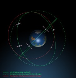
Galileo orbits viewed side-on. 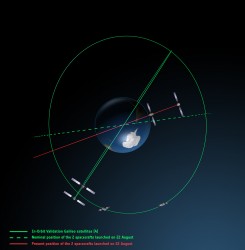
Galileo orbits viewed from above. The most plausible explanation for the anomaly is that the Soyuz – Fregat upper stage suffered a control malfunction at some point before its final orbital injection burn. So although the rocket engine seems to have fired correctly, the craft wasn’t pointing in the right direction.
In fact, I am told that a likely mechanical root cause for the anomaly in the Fregat stage has been identified by the inquiry committee; however, more information is being gathered and further technical analysis is required to verify this.
Can anything be done?
Doresa and Milena do not have enough fuel on board to achieve the correct orbit for full Galileo operations.
Some interesting solutions have been proposed to launch a rescue mission to drag the errant satellites into their correct orbit, but that could be a slow, risky and expensive exercise. So could the satellites be useful in situ?
For most GNSS uses, the answer is probably no. Despite the fact that the satellites themselves are apparently working perfectly, in a safe state, correctly pointing towards the Sun, properly powered and fully under control of the ESA team, their elliptical orbit does not conform with Galileo’s standardized data format. For example, the value that represents the shape of the satellites’ orbit is too big to be expressed within the allotted bit limit for that parameter.
Marco Falcone, ESA’s Galileo system manager, says his team have been working intensely to determine if the satellites can be at least partially recovered. Among the considerations are the flight dynamics of moving the two spacecraft and the impact of the radiation they are experiencing in their current location, which can shorten the satellite’s lifetime. “It’s very dangerous for the satellite,” admits Falcone.
Another unknown is the timing performance of the satellites’ rubidium frequency and hydrogen maser given the relativistic effects of their orbit. Signal issues, such as the navigation message almanac, also must be considered before the FOC satellites can be introduced into operation, Falcone said.
Good for geoscience?
But according to fellow GPS World contributor Richard Langley of the University of New Brunswick, the situation is more hopeful for scientists wanting to use Galileo-derived data in their research. Quoted in an article in leading science journal Nature, Richard says that researchers tracking GNSS satellites via the IGS global network of ground stations combine that information with the timing data transmitted by the satellites themselves and could use it to measure changes in the position of points on the ground much smaller than the one-metre margin of error for standard navigation-system receivers. This level of precision is good enough to detect millimetres of movement in tectonic plates, for example.
This reminded me of a presentation by a team of Italian scientists I saw recently. The VADASE (Variometric Approach for Displacements Analysis Stand-alone Engine) project uses a novel strategy consisting of an algorithm able to perform real-time retrieval and estimation of displacement and waveforms based on high-frequency (1 Hz or more) carrier phase observations collected by a stand-alone GNSS receiver. The algorithm works with broadcast data (satellite clocks and orbits), requires very simple hardware, and has demonstrated potential application in real-world situations such as earthquake risk assessment (and related early-warning systems for tsunamis) and structural monitoring (see citations below). VADASE had already achieved a Galileo-only displacement solution using the four IOV satellites in orbit.
I contacted Gabriele Colosimo at Rome’s “Sapienza” University, and he confirmed that, although the satellites could not be used for direct gravimetric studies that require a very low orbit (below 1,000 km), the data from Doresa and Milena could be used to estimate displacements of GNSS receivers. He and the VADASE team think that a slight adjustment in their algorithm might be needed depending on the exact orbit parameters of the satellites, but the data would be useable without any significant change in orbit being required.
Gabriele also thinks that the data could be used to usefully contribute to studies in fields such as troposphere studies and GNSS reflectometry, as well as for geodynamic and seismic monitoring using GNSS.
Munich Masters
Hopefully the mystery of Doresa and Milena’s anomaly will have been resolved by October 23, when the 2014 European Satellite Navigation Competition (ESNC) awards ceremony takes place in Berlin in conjunction with the two-day Satellite Masters Conference.
Gabriele and the VADASE team are in the running for a prize — so we wish them well.
But the real prize for the European GNSS community would be a full explanation of the recent Galileo issues, and how they are being resolved, and a clear statement and timeline on the future deployment and implementation of this flagship programme.
A bientôt – as they say in these parts
Citations
G.Colosimo, M. Crespi and A.Mazzoni, “Real-time GPS Seismology with a stand-alone receiver: A preliminary feasibility demonstration,” Journal of Geophysical Research, vol 116, doi: 10.1029/2010JB007941
M. Branzanti, G.Colosimo, M.Crespi and A.Mazzoni, “GPS near-real-time coseismic displacements for the great Tohoku-oki earthquake,” IEEE Geoscience and Remote Sensing Letters, vol 99, doi: 10.1109/LGRS.2012.2207704
-
Geospatial Solutions, GPS World at the 2014 Esri International User Conference
This is the mecca of geographic information systems, or GIS, at least in the United States: the 2014 Esri International User Conference (UC) in San Diego, California, held every July. GPS World and Geospatial Solutions were there in force. A newly dominant technology that got plenty of discussion was unmanned aerial systems (UAS or UAV). Eric Gakstatter, GPS World’s survey and GIS editor, said “I can boil where this technology is headed down to one word: real-time.”