Author: GPS World Staff

  • NASA launches micro satellites with GNSS receivers for remote weather sensing

    NASA launches micro satellites with GNSS receivers for remote weather sensing

    Surrey Satellite Technology’s Space GNSS Receiver Remote Sensing Instrument (SGR-ReSI) is the primary payload onboard NASA’s CYGNSS constellation, launched today, Dec. 15, from Cape Canaveral Air Force Station in Florida.

    The Cyclone Global Navigation Satellite System (CYGNSS) mission is part of the NASA Earth System Science Pathfinder Program that aims to improve extreme weather prediction by studying how tropical cyclones form.

    Artist's concept of one of the eight CYGNSS satellites in orbit. (Image: NASA/University of Michigan)
    Artist’s concept of one of the eight CYGNSS satellites in orbit. (Image: NASA/University of Michigan)

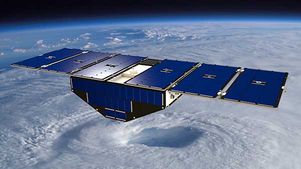
    The CYGNSS space segment consists of a constellation of eight micro satellites, each carrying the Surrey SGR-ReSI as the observatory payload in the form of a delay Doppler mapping instrument (DDMI). Making use of reflected global positioning signals, the DDMI collects ocean surface roughness data using a technique called GNSS reflectometry, providing CYGNSS with a new method for looking inside hurricanes. Wind speed will be estimated from this reflectometry data.

    “At the end of last year, we delivered the SGR-ReSI flight models, low-noise amplifiers, and antennas to Southwest Research Institute for final integration into the CYGNSS observatories — marking a significant hardware shipment out of our Englewood, Colorado, manufacturing facility,” said Clare Martin, vice president of programs at Surrey Satellite Technology U.S.. “All of us at Surrey are proud that our instrument is playing an integral role in this mission, and we will watch with great interest as the satellites are put to work.”

    The CYGNSS team is made up of the University of Michigan Department of Climate and Space Sciences and Engineering, Southwest Research Institute (SwRI), Surrey Satellite Technology and Sierra Nevada Corporation.

    Surrey Satellite Technology demonstrated the concept of GNSS reflectometry for the first time on its UK-DMC mission launched in 2003, and subsequently developed the SGR-ReSI, which is currently flying on Surrey’s TechDemoSat-1 mission.

    CYGNSS is NASA’s first Earth science small satellite constellation, designed to help improve forecasting hurricane intensity, hurricane tracks and storm surges.

    CYGNSS will measure previously unknown details crucial to accurately understanding the formation and intensity of tropical cyclones and hurricanes.

    “This is a first-of-its-kind mission,” said Thomas Zurbuchen, associate administrator for NASA’s Science Mission Directorate at the agency’s headquarters in Washington. “As a constellation of eight spacecraft, CYGNSS will do what a single craft can’t in terms of measuring surface wind speeds inside hurricanes and tropical cyclones at high time-resolution, to improve our ability to understand and predict how these deadly storms develop.”

    The CYGNSS mission is expected to lead to more accurate weather forecasts of wind speeds and storm surges — the walls of water that do the most damage when hurricanes make landfall.

    Using the same GPS technology that allows drivers to navigate streets, CYGNSS will use a constellation of eight micro satellite observatories to measure the surface roughness of the world’s oceans. Mission scientists will use the data collected to calculate surface wind speeds, providing a better picture of a storm’s strength and intensity.

    Unlike existing operational weather satellites, CYGNSS can penetrate the heavy rain of a hurricane’s eyewall to gather data about a storm’s intense inner core. The eyewall is the thick ring of thunderstorm clouds and rain that surrounds the calm eye of a hurricane. The inner core region acts like the engine of the storm by extracting energy from the warm surface water via evaporation into the atmosphere.

    The latent heat contained in the water vapor is then released into the atmosphere by condensation and precipitation. The intense rain in eyewalls blocks the view of the inner core by conventional satellites, however, preventing scientists from gathering much information about this key region of a developing hurricane.

    “Today, we can’t see what’s happening under the rain,” said Chris Ruf, professor in the University of Michigan’s Department of Climate and Space Sciences and Engineering and principal investigator for the CYGNSS mission. “We can measure the wind outside of the storm cell with present systems. But there’s a gap in our knowledge of cyclone processes in the critical eyewall region of the storm — a gap that will be filled by the CYGNSS data. The models try to predict what is happening under the rain, but they are much less accurate without continuous experimental validation.”

    The CYGNSS small satellite observatories will continuously monitor surface winds over the oceans across Earth’s tropical hurricane-belt latitudes. Each satellite is capable of capturing four wind measurements per second, adding as many as 32 wind measurements per second for the entire constellation.

    CYGNSS is the first complete orbital mission competitively selected by NASA’s Earth Venture program. Earth Venture focuses on low-cost, rapidly developed, science-driven missions to enhance our understanding of the current state of Earth and its complex, dynamic system and enable continual improvement in the prediction of future changes.

  • US Air Force approves Lockheed’s ground control upgrade for GPS III

    The U.S. Air Force approved Lockheed Martin’s design to upgrade the current GPS satellite ground control system with new capabilities that will enable it to operate more powerful and accurate GPS III satellites.

    The successful Critical Design Review (CDR) for the Contingency Operations (COps) contract, completed on Nov. 17, gives Lockheed Martin a green light to proceed with software development and systems engineering to modify the existing GPS ground control system, called the Architecture Evolution Plan (AEP) Operational Control Segment.

    SV 01 in testing at Lockheed Martin's Denver facility. (Photo: LMCO)
    SV 01 in testing at Lockheed Martin’s Denver facility. (Photo: LMCO)

    The AEP is currently maintained by Lockheed Martin and controls the 31 GPS IIR, IIR-M and IIF satellites in orbit today.

    The COps modifications will allow the AEP to support the more powerful, next generation GPS Block III satellites, enabling them to perform their positioning, navigation and timing mission, once they are launched. COps is envisioned as a temporary gap filler prior to the entire GPS constellation’s transition to operations onto the next generation Operational Control System (OCX) Block 1, currently in development.

    “The GPS constellation is a valuable asset to our warfighters, our nation and the world. This risk-reduction effort ensures the Air Force has the ability to maintain the constellation at full strength,” said Mark Stewart, vice president of Lockheed Martin’s Navigation Systems mission area. “We are here to support the Air Force and the GPS III program any way we can.”

    The Air Force awarded the $96 million COps services and supplies contract to Lockheed Martin on February 3. The government approved the company’s proposed ground system modification during a Preliminary Design Review on May 11.

    On Oct. 15, under a separate contract, Lockheed Martin completed the Commercial Off-the-Shelf (COTS) Upgrade #2 (CUP2) project — part of a multi-year plan to refresh the AEP’s technology and enhance the system’s ability to protect data and infrastructure from internal and external cyber threats, as well as improve its overall sustainability and operability. CUP2 is now fully operational and managing the current GPS constellation.

    Lockheed Martin has a long history of supporting ground systems, providing operations, sustainment and logistics support for nearly 60 Department of Defense satellites, including GPS, often allowing them to double their on-orbit operational design life.

    Lockheed Martin also is under contract to develop and build the Air Force’s first ten GPS III satellites, which will deliver three times better accuracy, provide up to eight times improved anti-jamming capabilities and extend spacecraft life to 15 years, 25 percent longer than the newest GPS satellites on-orbit today.

    GPS III’s new L1C civil signal also will make it the first GPS satellite to be interoperable with other international global navigation satellite systems.

  • Datumate introduces new DatuFly release 

    Datumate introduces new DatuFly release 

    Datumate has launched a new version of DatuFly for iOS, a UAV app with industry-specific capabilities for surveying, construction and infrastructure companies.

    Photo: DatumateThe new version 1.1.1. includes:

    • DJI Inspire 1 Pro Support – Two new bundles were added to support DJI Inspire 1 Pro drones, one with the X5 camera and the other with the X3.
    • DJI Matrice 600 Support – A new bundle was added to support DJI Matrice 600 with X5 camera.
    • Speed Control for Vertical Missions – Control the drone speed when taking vertical images. This includes the option of taking images when the drone is hoovering.
    • Optional Automatic Takeoff and Landing – Application is set by default to “manual takeoff and landing” for safety purposes. The operator will need to turn it off to enable automatic takeoff and landing. With manual takeoff and landing option, the operator will be asked to manually elevate the drone to a certain height and then start the automatic mission. When the mission is completed the operator will be asked to manually bring the drone back.
    • More Flexible Control of Mission Altitude — The operator can flexibly set the mission altitude for both oblique and vertical missions.
    • Control the Camera Angle for Oblique Missions – The operator has the option to change the angle if needed for oblique mission.
    • Chinese language support – DatuFly has a Chinese user interface.

    The app is available through the Apple Store.


  • 2016 fleet management technology report now available

    2016 fleet management technology report now available

    A new report that explores technologies for U.S. commercial fleets is now available.

    The 2016 Fleet Management Technology Report, sponsored by GPS Insight, includes results of a survey conducted by Bobit Business Media, publisher of Automotive Fleet Magazine, Fleet Financials Magazine, Business Fleet Magazine, and Work Truck Magazine.

    Cover: 2016 Fleet Management Technology ReportGPS Insights asked a series of questions pertaining to fleet management and telematics to examine the current state and experiences of the marketplace.

    Commercial fleets across the U.S. are finding that telematics is providing insight they never had before which helps to reduce costs, reduce risk, and increase revenue. Most industry reports state that the adoption rate is somewhere between 30-40 percent. The findings in this report are similar, and includes additional data broken down by region, fleet size, and industry.

    “We put this report together for business owners and fleet managers to get a clear understanding of what their peers are saying about their experience with telematics,” said Ryan Driscoll, marketing director of GPS Insight. “We also want it to serve as a guide for those looking to implement a better telematics solution or for those looking for the first time.”

    Topics covered in the report include:

    • Adoption: Who is and isn’t using telematics
    • Choosing a provider: What fleets say is important to consider
    • Benefits: How it’s helping commercial businesses
    • Return on investment: What fleets should expect from the investment

    The report can be downloaded from the GPS Insight website.

  • Septentrio reference receivers to monitor volcanoes for USGS

    Pictured are the Three Sisters volcanoes in Central Oregon. Photo: USGS / Lyn Topinka
    Pictured are the Three Sisters volcanoes in Central Oregon.
    Photo: USGS / Lyn Topinka

    Septentrio has completed delivery of PolaRx5 multi-constellation GNSS reference receivers and antenna systems to the U.S. Geological Survey (USGS).

    The monitoring systems will be deployed through the Volcano Hazards Program (VHP) for volcano monitoring stations in Alaska and at various international locations through the Volcano Disaster Assistance Program (VDAP) — a cooperative effort between the USGS and the U.S. Agency for International Development’s Office of U.S. Foreign Disaster Assistance.

    The PolaRx5 receivers take full advantage of the new 5.1.0 firmware which includes support for onboard PPP and dynamic response tuned for seismic applications. The PolaRx5 tracks all visible signals from Galileo, GPS, GLONASS, BeiDou, IRNSS and QZSS constellations. It provides measurement quality and robust interference mitigation through Septentrio’s patented AIM+ technology. The PolaRx5 supports these advanced features and more with a power consumption that is scalable from less than 2.0 watts.

    “USGS and their partners will be among the first to exploit the PolaRx5’s seismic monitoring features,” said Neil Vancans, vice president of Septentrio Americas. “The PolaRx5 is Septentrio’s most complete GNSS receiver to date and provides the ideal upgrade for modernizing any continuously-operating reference station (CORS) network.”

  • Septentrio provides low-power embedded GNSS for Xeos autonomous reference receiver

    Septentrio provides low-power embedded GNSS for Xeos autonomous reference receiver

    The AsteRx-m UAS by Septentrio.
    The AsteRx-m UAS by Septentrio.

    Septentrio’s low-power AsteRx-m OEM GNSS board has been selected by Xeos Technologies for use in its new Resolute reference receivers. Designed for high-precision monitoring in low-power applications, the Resolute systems are aimed at structural monitoring and geodetic research in remote locations.

    Smaller than a standard credit card, the AsteRx-m board provides centimeter-level dual-frequency L1/L2 GNSS positioning while consuming less than 0.6 W. It incorporates Septentrio’s proprietary tracking and positioning algorithms, providing high accuracy and robust performance in difficult environments.

    The Xeos Resolute GNSS receiver is designed for applications such as critical infrastructure monitoring, subsidence monitoring and GPS geodesy in extreme polar environments. The small, lightweight and low-power monitoring station is suitable for solar-powered remote autonomous installations.

    In addition to the Septentrio AsteRx-m GNSS board, the Resolute system features dual SD card storage of GNSS data and multiple telemetry options such as Iridium, cellular, Wi-Fi and wireless mesh networks for monitoring, control and data transmission. The Xeos Resolute also features multiple interfaces including USB, RS-232, RS-485, CANBUS and SDI-12.

    “Field tests of the prototype Resolute stations have demonstrated reliable RTK centimeter-level performance for remote deformation monitoring,” said Paul Passmore, Xeos Technologies. “We look forward to presenting our test results at the American Geophysical Union Fall Meeting in San Francisco this week.”

    “Xeos Technologies’ Resolute autonomous polar monitoring system is an ideal application for the AsteRx-m technology,” said Neil Vancans, vice president of Septentrio Americas. “The compact AsteRx-m delivers reliable centimeter-level L1/L2 RTK at under 0.6 W in extreme climatic conditions.”

    “Building upon our polar Iridium telemetry products, we are teaming with Septentrio to offer a new line of high-performance, low-power GNSS products for remote applications” said Derek Inglis, president of Xeos Technologies.

  • Geneq introduces SXPad 1000P rugged handheld

    Geneq introduces SXPad 1000P rugged handheld

    SXPad 1000P by Geneq.
    SXPad 1000P by Geneq.

    Geneq Inc. has announced the SXPad 1000P, a rugged handheld GPS data collector, which the company says is low-cost.

    The SXPad 1000P is suitable for mobile GIS users in applications ranging from water, electric, gas utilities, transportation, mining, agriculture and forestry.

    The high-performance 1000-megahertz device is designed to give professionals the power needed to work with maps and large data sets in the field. Its waterproof seal (IP67) and surviving 5-foot (1.5-meter) drops to concrete make the SXPad 1000P ideal for the outdoors. Its 3.7-inch color touchscreen (full VGA) is sharp and is sunlight readable.

    Standard features include a battery life of more than 10 hours on a charge, 8-GB internal storage, slots for MicroSD cards and SIM cards as well as Windows Mobile 6.5.

    The SXPad 1000P offers features typically seen in more costly mobile devices, the company said. These include 3.5G cellular modem, Wi-Fi, Bluetooth, video capture, a 5-megapixel camera and an internal GPS receiver.

    The SXPad 1000P is optimized for GPS/GIS field data collection using its 1-3 meter accuracy internal GPS receiver or one of Geneq’s high-performance SXBlue GPS receivers for sub-meter and centimeter-level accuracy.

  • New GLONASS interface control documents released

    Russian Space Systems has released draft versions of the GLONASS interface control documents (ICD) for the future code division multiple access (CDMA) signals in the L1, L2 and L3 bands.

    Parameters of the subsystem interfaces between the spacecraft and GLONASS navigation consumer equipment are determined by the GLONASS Interface Control Document.

    The ICD is only available in Russian, but an English translation is expected soon.

    PDF files of the documents for each signal can be downloaded here:

    http://russianspacesystems.ru/wp-content/uploads/2016/08/IKD-L1-s-kod.-razd.-Red-1.0-2016.pdf
    http://russianspacesystems.ru/wp-content/uploads/2016/08/IKD-L2-s-kod.-razd.-Red-1.0-2016.pdf
    http://russianspacesystems.ru/wp-content/uploads/2016/08/IKD-L3-s-kod.-razd.-Red-1.0-2016.pdf
    http://russianspacesystems.ru/wp-content/uploads/2016/08/IKD.-Obshh.-opis.-Red.-1.0-2016.pdf

  • GPS World remembers defense columnist Don Jewell

    GPS World remembers defense columnist Don Jewell

    don_jewell_4cDon Jewell passed away unexpectedly on Oct. 12. For more than nine years, Don wrote the Defense PNT monthly e-newsletter column for GPS World, after a distinguished 30-year career in the U.S. Air Force, retiring as Deputy Chief Scientist for Air Force Space Command with the rank of Lieutenant Colonel. A celebration of his life was held Oct. 20 in Colorado Springs.

    Born in Louisville, Kentucky, Don earned a bachelor’s degree in political science from the University of Kentucky and a master’s degree from the University of Oklahoma. He served in the U.S. Air Force as an aviator, navigator and space subject matter expert, and completed two Command assignments at Schriever Air Force Base.

    His involvement with GPS began in 1978, either as a test system evaluator or user. As Politico-Military Affairs Officer in the Reagan White House, he worked with foreign embassies making critical export control decisions concerning sophisticated military hardware and software.

    After the Air Force, Don worked seven years as senior space executive at Motorola and General Dynamics and as senior VP at Infofusion.

    He worked at the Institute for Defense Analyses (IDA) as a member of several advisory committees to the Department of Defense and U.S. government: the GPS Independent Review Team (IRT), Space Programs Assessment Group for SMC, Independent Assessment Team for WAAS and as Co-Chair of Military Critical Technologies Program for Space.

    A close friend said, “Don was a real pillar for the PNT community and consummate spokesman for the truth, always offering constructive criticism where needed. An exemplary personality who always ‘did the right thing.’”

    Another colleague remembered, “Don was a key player in all tasks undertaken in response to the Commander Space Command. One of his many significant roles was as key IRT debriefer of warriors returning to the U.S. through Ft. Carson following operational deployments, to get candid inputs on what shortfalls in PNT they had using GPS to execute their missions, so that Don could make sure DoD leadership didn’t get complacent in management and operation of GPS.

    “His use of PNT as a vehicle for constant improvement was driven by Don selflessly serving our national security, helping our soldiers, sailors, marines, airmen and others operating in harm’s way to serve our country well in his passionate and very candid role with his ‘constructive criticism’ counsel to Air Force and DoD leadership to assure the troops’ mission success, returning home safely often after intense combat. A tragic loss to our Nation, as he did this for many years.”

    Don began writing the Defense PNT e-newsletter for GPS World in April 2007. His first column is lost in the mists of time, but here is an excerpt from his second column, May 2007:

    “To think that all these billion-dollar companies, and the start-ups as well, depended to such a great degree on a ubiquitous utility that only became available on a global basis because of a seemingly insignificant, but in the end, deadly navigation error. Add to this the naked aggression and paranoia of the former Soviet Union and the benevolence and caring of a legendary U.S. President, and you have the beginnings of a tale that has changed our world forever, and whose final chapter may never be written.”

    Don was active in the Military Division of the Institute of Navigation (ION). From 2010–2015, he helped assemble and co-chaired the Warfighter Crosstalk Panel in the Joint Navigation Conference (JNC); this was and remains today one of the most interesting and informative sessions of that conference, focusing on needs of military and first responder users for PNT.

    Don regularly led weekly bible study meetings for more than 20 years and was recently appointed as president of Christ the King Lutheran Church.

    Readers’ and friends’ appreciations appear at gpsworld.com/donjewell. Send further remembrances to [email protected]. Contributions in Don’s memory may be made to Christ the King Lutheran Church or the Amyloidosis Foundation.

  • Towering solutions: Using GNSS, BIM and a head-up display for speed, safety

    Towering solutions: Using GNSS, BIM and a head-up display for speed, safety

    Modern tower cranes can reach a height of more than 200 meters. They operate in a complicated, chaotic and constantly changing environment. This creates obstacles for the crane operator: poor visibility and dead angles — places the operator can’t see.

    Aiming to solve the problem is the Augmented Crane Navigation System (ACNS) project, which provides innovative intelligent operation of tower cranes on construction sites through the integration of highly accurate navigation receivers and a powerful processor unit.

    Photo © Natasza Figiel
    Photo © Natasza Figiel

    Polish researcher Piotr Krystek took home the DLR Special Prize from the European Satellite Navigation Competition (ESNC) for the ACNS, which is designed to increase efficiency and safety at construction sites.

    Using the ACNS, the position of the crane elements can be determined and oriented using four to five low-cost yet highly precise Galileo or GNSS receivers. The central processor calculates the best possible route for load management. In addition to the position values of the various satellite navigation receivers, the digital model of the physical structure or Building Information Model (BIM) is used. Using a head-up display, the visualization is projected directly onto the crane operator’s field of view to enable easy and precise navigation.

    The ACNS has a modular design and can be mounted on the crane easily; this includes the retrofitting of existing cranes.

    The project is still in the concept phase. To implement the idea, the market must be explored and feasibility studies carried out with cranes in collaboration with crane manufacturers, Krystek said.

    The ACNS also could be transferred to other construction machinery and commercial vehicles, Krystek said. As one of the leading economic sectors, the construction industry can benefit immensely from GNSS-based solutions.

    Krystek was inspired to pursue the project because of the tower cranes visible from his window in Krakow — along with the availability of low-cost RTK receivers. He is also inspired by the trend to automate everything that can be automated, such as self-driving cars.

  • Launchpad: Tiny simulator, defense atomic clock

    Launchpad: Tiny simulator, defense atomic clock

    OEM

    Entry-level testing

    Modular approach for developers

    Spirent Communications' GSS 7000 series of multi-frequency GNSS simulators provides an option for entry-level testing.
    Spirent Communications’ GSS 7000 series of multi-frequency GNSS simulators provides an option for entry-level testing.

    The GSS7000 series of multi-frequency, multi-GNSS RF constellation simulators provides an entry to multi-frequency testing, with a modular approach that expands with users’ needs. The GSS7000 system is for receiver, system and application developers who want to take advantage of new satellite navigation systems and the better accuracy offered by civilian, multi-frequency GNSS. It provides faithful emulation of all civil GNSS systems and regional augmentation systems, and allows devices to be tested under a multitude of operating environments and error conditions.

    Spirent Communications, www.spirent.com

    All-signals board

    Machine control, marine survey

    p328-hemisphere-wThe Eclipse P328 is a multi-frequency, multi-GNSS all-signals receiver board that includes Hemisphere’s newest hardware platform and integrates Atlas GNSS Global Corrections. It is designed for land or marine survey, machine control, and any application where high-accuracy positioning is required. With the new hardware platform, the overall cost, size, weight and power consumption of the P328 are reduced. It offers true scalability with centimeter-level accuracy in either single-frequency mode or full performance multi-frequency, multi-GNSS, Atlas-capable mode that supports fast real-time kinematic (RTK) initialization times over long distances. The P328 uses the Athena GNSS engine, as well as Hemisphere’s new aRTK technology powered by Atlas. This feature allows the P328 to operate with RTK accuracies when RTK corrections fail.

    Hemisphere GNSS, hemispheregnss.com

    Upgradeable board

    Increased accuracy services available through software

    onyx-board-wThe Onyx multi-frequency GNSS OEM board offers integrated StarFire/real-time kinematic (RTK) GNSS capabilities. Onyx features 255-channel tracking, including multi-constellation support for GPS, GLONASS, BeiDou and Galileo. It also provides high performance in GNSS receiver sensitivity and signal tracking as well as patented multi-path mitigation, interference rejection and anti-jamming capabilities. Through software, it can be upgraded from free DGPS signal sources such as WAAS to increased accuracy services with integrated StarFire with Rapid Recovery or RTK with RTK Extend.

    NavCom Technology, www.navcomtech.com

    GPS/GNSS simulator

    The size of a deck of cards

    jackson_labs-claw-wThe CLAW is a self-contained, ruggedized, miniature, real-time hardware GPS simulator. It targets applications that require small, low-power and low-cost GNSS synthesis with repeatable and highly accurate GNSS RF signals such as production testing of GNSS receivers, simulating GNSS anomalies such as leap-second events, 1023 GPS Week rollovers, operation in inaccessible locations, real-time transcoding of different GNSS systems, and testing using dynamically user-configured RF signal levels. The CLAW contains real-time processing hardware to simulate GPS constellations without the need to connect any external equipment other than a USB power source or power supply.

    Jackson Labs Technologies, www.jackson-labs.com

    Defense atomic clock

    For critical applications in dynamic environments

    The Spectratime Force 2020 Rubidium clock is designed for the defense market.
    The Spectratime Force 2020 Rubidium clock is designed for the defense market.

    The Force 2020 is a rugged, anti-vibration, GPS/GNSS-lockable, ultra-low-noise Rubidium atomic clock for highly dynamic defense platform applications. It is designed for next-generation defense airborne radars, drones, helicopters, and secure shipboard and radio communications systems. These systems use high K-band frequencies that require ultra-low-noise performance, which can only be minimally degraded in tactical missions when exposed to dynamic vibration and high-g environments.

    Spectratime, www.spectratime.com


    SURVEY & MAPPING

    Rugged handheld

    Ready for tough field jobs

    SXPad_800H_main-WThe SXPad 800H is a rugged handheld GPS data collector designed for mobile geographic information system (GIS) users in applications such as water, electric and gas utilities; transportation; mining; agriculture; and forestry. The high-performance 800-MHz device is designed to give users the power needed to work with maps and large data sets in the field. It is created for rugged outdoor use, with a waterproof seal (IP65) and ability to survive a five-foot (1.5-meter) drop to concrete. Its 3.7-inch VGA color touchscreen is sharp and sunlight readable. Features include a battery life of 12 hours on a charge, slots for MicroSD and SIM cards, and the Windows Mobile 6.5 operating system.

    Geneq, www.geneq.com

    Drone/software

    Partnership for site surveys

    dji-datumate-surveysolution-wThe DJI-Datumate Site Survey Solution is a comprehensive and professional package of imagery and mapping tools that help surveying, construction, inspection and infrastructure companies generate a working model, visualize a site, and create analytics and plans. The drone, software and app package automates and expedites site surveys, infrastructure mapping and inspection. Bundles include a DJI Drone, a DatuFly tablet app for automated aerial photography, and DatuGram 3D photogrammetry software that converts aerial and ground images to high-precision, geo-referenced 2D maps and 3D models. DatuFly software generates a flight and image-taking plan for the drone based on the best-practice requirements of DatuGram 3D photogrammetry, ensuring survey-grade accuracy.

    DJI, www.dji.com; Datumate, datumate.com

    Wearable receiver

    Takes high accuracy into difficult terrain

    asteri-series-xDesigned for geospatial field data collection and inspection applications that require high-accuracy positioning, the Asteri X-Series of receivers are light enough to be mounted to external sensors or worn on the body or arm. The compact receivers were designed for safety and ease of use. Each device weighs 11.3 ounces with a 12-hour lithium battery. Their 2.8-inch by 5.4-inch size allows them to fit safely in shoulder or arm pouches. The three products in the X-Series provide varying levels of accuracy: X-1 provides sub-meter accuracy out of the box; X-2 offers accuracy of 1 meter down to 1 cm with RTK/VRS; X-3 will achieve 1 cm with RTK/VRS, 30 cm with Atlas H30, 4–10 cm with Atlas H10. The integrated design allows users to work in difficult terrain without worrying about equipment and antennas getting snagged or broken.

    Asteri Navigation, asterinav.com


    TRANSPORTATION

    Autonomous navigation module

    Performs dead-reckoning for in-vehicle systems

    telit-jupiter-sl869-3dr-wThe SL869-3DR is a GNSS module for global use that leverages information from internal gyros, accelerometers and a barometric pressure sensor to perform dead-reckoning navigation for application areas such as track and trace and in-vehicle systems. The module delivers accurate position data either directly from its multi-constellation receiver or from a fully autonomous dead-reckoning system, requiring no connections to external devices or components other than an antenna for satellite signal reception and power. The module allows integrators to design zero-installation, in-vehicle navigation and tracking devices for fleets and other commercial or consumer applications that operate perched on the dashboard, connected only to vehicle power. The SL869-3DR is designed to support GPS, QZSS, GLONASS, Beidou and is Galileo ready.

    Telit, www.telit.com

    IMU for aviation

    Soon to be in Boeing 777x

    systron_donner_boeing_777xThe SDI300 aviation-grade inertial measurement unit (IMU) delivers reliable high performance and stability over full temperature and vibration environments. The compact, low-power, high-quality SDI300 IMU enables efficient and smooth aircraft maneuvers through the most complex flight scenarios and challenging environments, while improving total system cost-effectiveness, reduced obsolescence and increased sustainability. In November, Rockwell Collins awarded a contract to Systron Donner Inertial for the SDI300, to be used in the new Boeing 777X Integrated Flight Control Electronics fly-by-wire system.

    Systron Donner Inertial, www.systron.com


    UAV

    Depth finder

    Optimized for UAVs

    riegl_bathycopter_with_bdf-wThe Bathymetric Depth Finder is fully integrated to Riegl’s Bathycopter, enabling the generation of profiles of inland water bodies. The BDF-1 is a compact and lightweight bathymetric depth finder optimized for UAV-borne operation. The topo-bathymetric depth finder comprises tilt compensation, an IMU/GNSS unit with antenna, a control unit and a data storage unit. It can be equipped with two external digital cameras. Riegl’s new hydrographic full waveform processing delivers highly accurate, reliable and informative data; pre-detection averaging allows essential performance in adverse conditions.

    Riegl, www.riegl.com

    Professional drone

    Withstands magnetic interference

    dji-matrice600pro-wThe updated Matrice 600 Pro offers improved flight performance, a more powerful battery charging system and better loading capacity for industrial equipment, cinema cameras and other professional aerial applications. The A3 Pro flight controller comes with triple modular redundancy and diagnostic algorithms that compare sensor data from three sets of GNSS units, enhancing precision control while improving overall safety. Vibration damping balls have been added to the flight controller’s redundant inertial measurement unit module and main controller, absorbing more shake and reducing more noise. Compatibility with D-RTK GNSS makes the A3 Pro withstand magnetic interference and provides centimeter-level accuracy suitable for industrial applications.

    DJI, dji.com

  • Septentrio’s PolaRx5 updated with seismic monitoring, advanced CORS

    Septentrio’s PolaRx5 updated with seismic monitoring, advanced CORS

    The Septentrio PolaRx5 GNSS receiver.
    The Septentrio PolaRx5 GNSS receiver.

    Septentrio has released version 5.1.0 firmware for the PolaRx5 product line of GNSS reference receivers. The 5.1.0 firmware brings new features for file management, usability, security and seismic monitoring.

    Septentrio’s PolaRx5 product line of GNSS reference receivers includes the PolaRx5 for CORS and network operations, the PolaRx5TR for time and frequency transfer and the PolaRx5S for space weather applications.

    Improvements in precise point positioning (PPP) have opened the door on seismic monitoring using GNSS technology. As well as allowing precise measurement of long-term slow surface displacement, PolaRx5 now allows real-time recording of the high-frequency vibrations typically accompanying earthquakes. Firmware 5.1.0 introduces the support for on-board PPP and dynamic response tuned for seismic applications.

    The 5.1.0 firmware release brings greater logging efficiency to the PolaRx5 users. Storage integrity is crucial for many applications. Retransmitting data can be an expensive business, especially when using Iridium telemetry. To improve archival functionality, Septentrio has developed a storage integrity feature to retransmit only the data which has been lost in the initial transmission. This avoids the common and unnecessary overhead of retransmitting complete files.

    Preventing unauthorized access is a crucial aspect of cyber security. PolaRx5 product line is now equipped with firewall and IP filtering, SFTP and ssh keys. This complements and strengthens the user management and access level protection of the PolaRx5 product line.

    Various independent tests have shown PolaRx5 consistently ranks highest among GNSS receivers in many areas of measurement quality, including lowest measurement noise and fewest number of cycle slips, and this at the lowest power consumption on the market. The PolaRx5 products offer robust and high-quality GNSS tracking of GPS, GLONASS, Galileo and BeiDou as well as regional satellite systems including QZSS and IRNSS.

    Some of those who have recently deployed the PolaRx5 include the Oregon Department of Transport (DOT), UNAVCO, the Jet Propulsion Laboratory (JPL) and the SAPOS CORS network in Germany.

    “The 5.1.0 PolaRx5 firmware continues Septentrio’s commitment to its customers.” stated Francesca Clemente, PolaRx Product Manager. She continued: “The new features of the 5.1.0 firmware complement existing standard features of the PolaRx5 GNSS receivers such as Advanced Interference Mitigation technology (AIM+) and the web UI offering full user control and status to make PolaRx5 the most complete GNSS reference station on the market today.”